Filtered by Category:Canada(Show All Categories)
Showing results for:Auction 192
Catalog Archive
38 lots
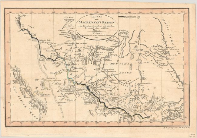
Auction 192, Lot 106
Subject: Canada
Weimar Geographisches Institut
Charte von MacKenzie's Reisen von Montreal zu dem Nordlichen Eis=und dem Stillen Meere, 1802
Size: 11.4 x 7.4 inches (29 x 18.8 cm)
Estimate: $140 - $170
NO RESERVE
Sold for: $65
Closed on 4/26/2023
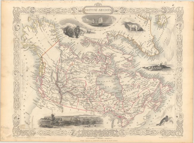
Auction 192, Lot 107
Subject: Canada
Tallis, John
British America, 1850
Size: 12.9 x 10.2 inches (32.8 x 25.9 cm)
Estimate: $240 - $300
Sold for: $180
Closed on 4/26/2023
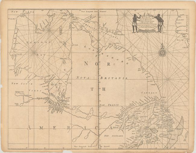
Auction 192, Lot 108
Subject: Eastern Canada
Mount & Page
A New and Correct Chart of the North Part of America from New Found Land to Hudsons Bay, 1753
Size: 22.2 x 17.2 inches (56.4 x 43.7 cm)
Estimate: $300 - $375
Sold for: $170
Closed on 4/26/2023
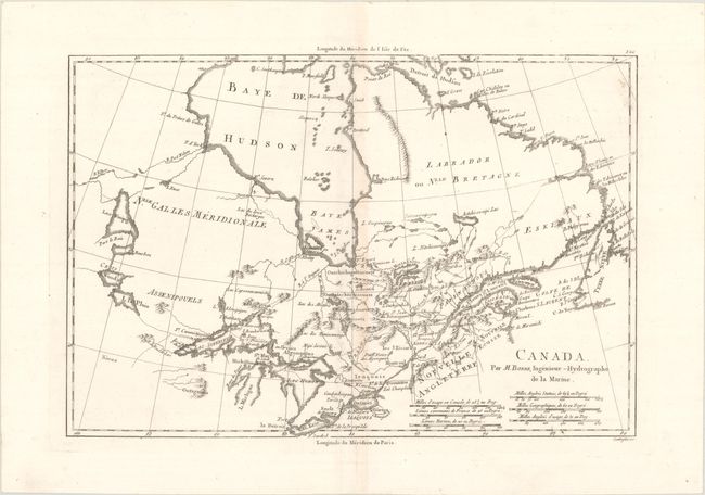
Auction 192, Lot 109
Subject: Eastern Canada
Bonne, Rigobert
Canada, 1790
Size: 13.5 x 9.1 inches (34.3 x 23.1 cm)
Estimate: $120 - $150
Sold for: $75
Closed on 4/26/2023
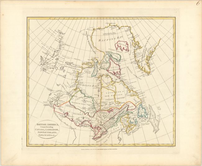
Auction 192, Lot 110
Subject: Eastern Canada
Cruttwell, Clement
British America, Comprehending Canada, Labrador, New-Foundland, Nova Scotia &c:, 1808
Size: 15.4 x 13.3 inches (39.1 x 33.8 cm)
Estimate: $275 - $350
Sold for: $150
Closed on 4/26/2023
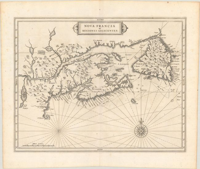
Auction 192, Lot 111
Subject: Eastern Canada
de Laet, Joannes
Nova Francia et Regiones Adiacentes, 1630
Size: 14.1 x 11.1 inches (35.8 x 28.2 cm)
Estimate: $1,200 - $1,500
First Accurate Depiction of Prince Edward Island
Sold for: $1,200
Closed on 4/26/2023
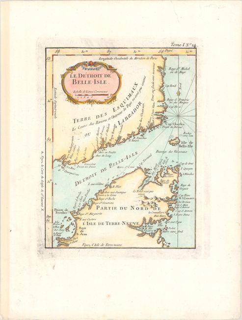
Auction 192, Lot 112
Subject: Eastern Canada
Bellin, Jacques Nicolas
Le Detroit de Belle-Isle, 1764
Size: 6.3 x 8.3 inches (16 x 21.1 cm)
Estimate: $90 - $110
Sold for: $75
Closed on 4/26/2023
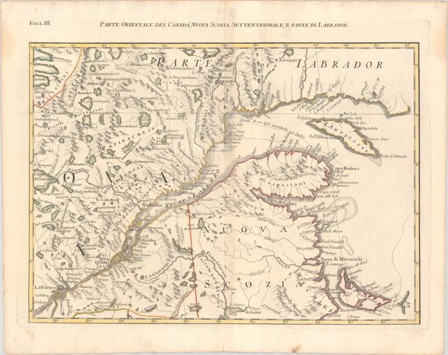
Auction 192, Lot 113
Subject: Eastern Canada
Zatta, Antonio
Parte Orientale del Canada, Nuova Scozia Settentrionale, e Parte di Labrador, 1780
Size: 16.6 x 12.1 inches (42.2 x 30.7 cm)
Estimate: $200 - $230
Unsold
Closed on 4/26/2023
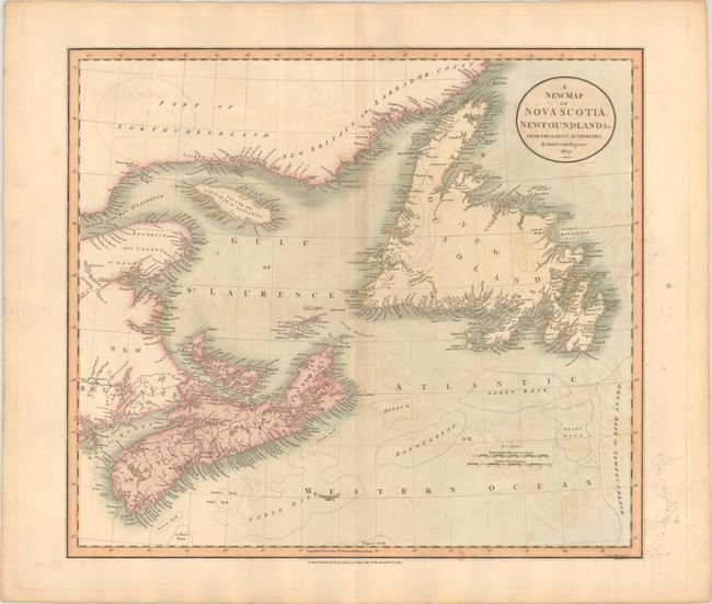
Auction 192, Lot 114
Subject: Eastern Canada
Cary, John
A New Map of Nova Scotia, Newfoundland &c. from the Latest Authorities, 1807
Size: 20.6 x 18.2 inches (52.3 x 46.2 cm)
Estimate: $120 - $150
Sold for: $90
Closed on 4/26/2023
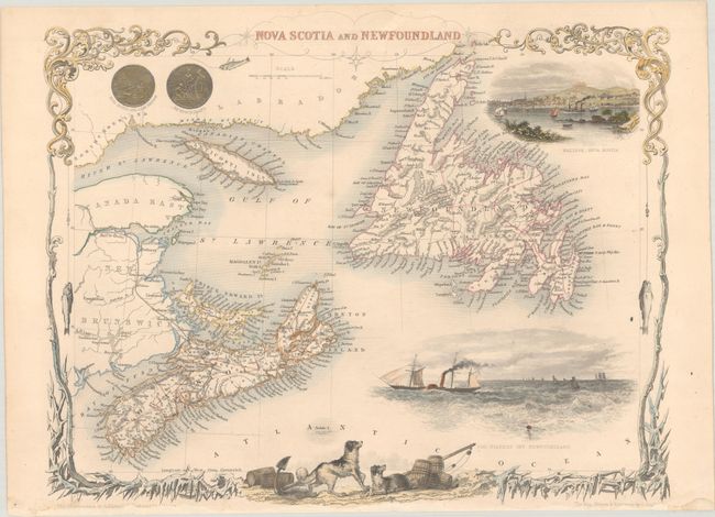
Auction 192, Lot 115
Subject: Eastern Canada
Tallis, John
Nova Scotia and Newfoundland, 1850
Size: 13 x 10.3 inches (33 x 26.2 cm)
Estimate: $140 - $170
Sold for: $140
Closed on 4/26/2023
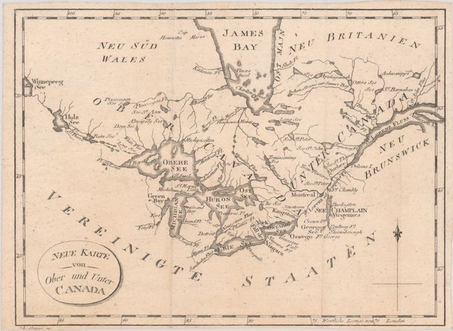
Auction 192, Lot 116
Subject: Eastern Canada, Great Lakes
Stockdale, John
Neue Karte von Ober und Unter Canada, 1801
Size: 8.9 x 6.6 inches (22.6 x 16.8 cm)
Estimate: $100 - $130
Sold for: $50
Closed on 4/26/2023
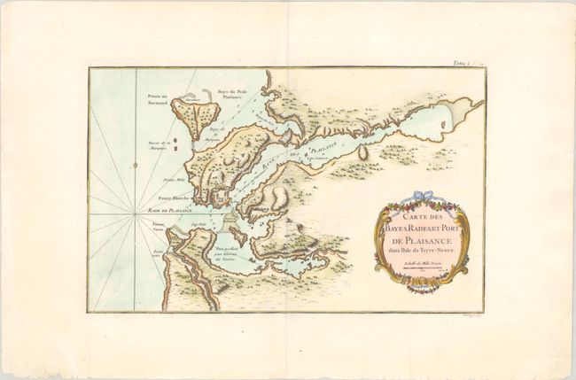
Auction 192, Lot 117
Subject: Newfoundland, Canada
Bellin, Jacques Nicolas
[Lot of 3] Carte des Bayes, Rades, et Port de Plaisance dans l'Isle de Terre-Neuve [and] Plan de la Rade et Port de l'Isle St. Pierre [and] Carte du Havre de Saint Jean dans l'Isle de Terre-Neuve, 1764
Size: See Description
Estimate: $250 - $325
Sold for: $150
Closed on 4/26/2023
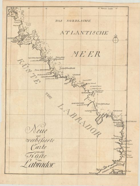
Auction 192, Lot 118
Subject: Labrador, Canada
Weygand, F.
Neue und Verbesserte Carte von der Kuste von Labrador, 1781
Size: 11 x 14.1 inches (27.9 x 35.8 cm)
Estimate: $600 - $750
Unsold
Closed on 4/26/2023
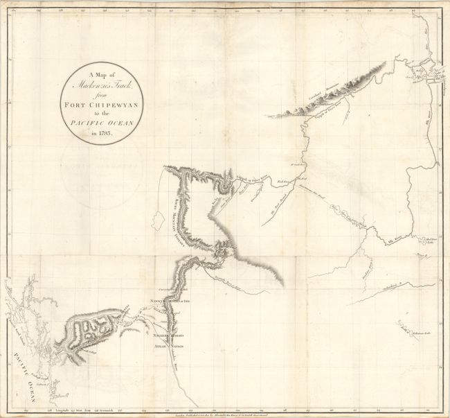
Auction 192, Lot 119
Subject: Western Canada
Mackenzie, Alexander
A Map of Mackenzie's Track; from Fort Chipewyan to the Pacific Ocean in 1793, 1801
Size: 24.1 x 22.1 inches (61.2 x 56.1 cm)
Estimate: $1,000 - $1,300
Unsold
Closed on 4/26/2023
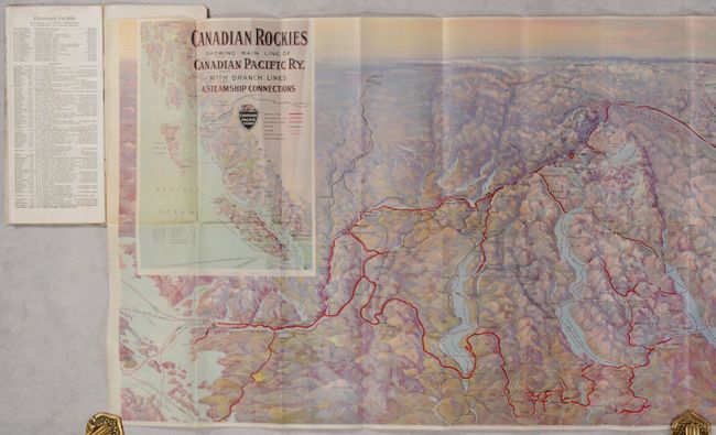
Auction 192, Lot 120
Subject: Western Canada
Railroad Companies, (Various)
[Map in Booklet] Canadian Rockies Showing Main Line of Canadian Pacific Ry. with Branch Lines & Steamship Connections [in] Resorts in the Canadian Rockies, 1930
Size: 46.3 x 16.8 inches (117.6 x 42.7 cm)
Estimate: $100 - $130
Sold for: $75
Closed on 4/26/2023
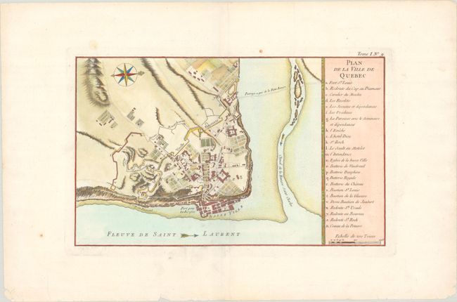
Auction 192, Lot 121
Subject: Quebec City, Canada
Bellin, Jacques Nicolas
Plan de la Ville de Quebec, 1764
Size: 13.7 x 8.4 inches (34.8 x 21.3 cm)
Estimate: $160 - $190
Sold for: $75
Closed on 4/26/2023
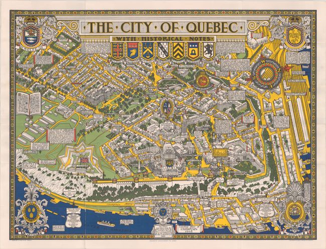
Auction 192, Lot 122
Subject: Quebec City, Canada
The City of Quebec with Historical Notes, 1932
Size: 33.4 x 25 inches (84.8 x 63.5 cm)
Estimate: $200 - $230
Sold for: $110
Closed on 4/26/2023
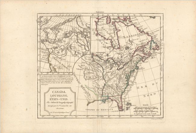
Auction 192, Lot 123
Subject: United States & Canada
Robert de Vaugondy/Delamarche
Canada, Louisiane, Etats-Unis, 1794
Size: 11.7 x 9.5 inches (29.7 x 24.1 cm)
Estimate: $230 - $275
Sold for: $170
Closed on 4/26/2023
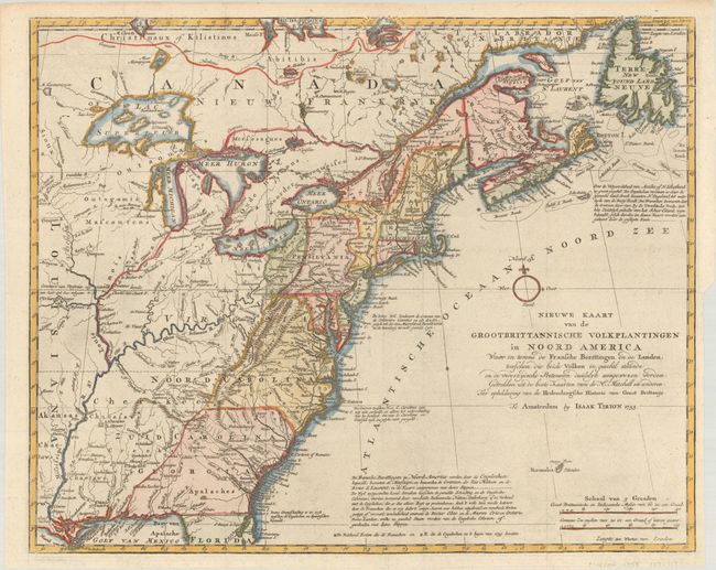
Auction 192, Lot 125
Subject: Colonial Eastern United States & Canada
Tirion, Isaac
Nieuwe Kaart van de Grootbrittannische Volkplantingen in Noord America waar in Tevens de Fransche Bezittingen en de Landen, Tusschen die Beide Volken in Geschil Staande..., 1755
Size: 17.9 x 14.5 inches (45.5 x 36.8 cm)
Estimate: $600 - $750
Sold for: $475
Closed on 4/26/2023
Auction 192, Lot 126
Subject: Colonial Eastern United States & Canada
Le Rouge, George Louis
[Canada et Louisiane], 1755
Size: 19.6 x 24.3 inches (49.8 x 61.7 cm)
Estimate: $1,200 - $1,500
Rare First State of Uncommon French & Indian War Map
Sold for: $750
Closed on 4/26/2023
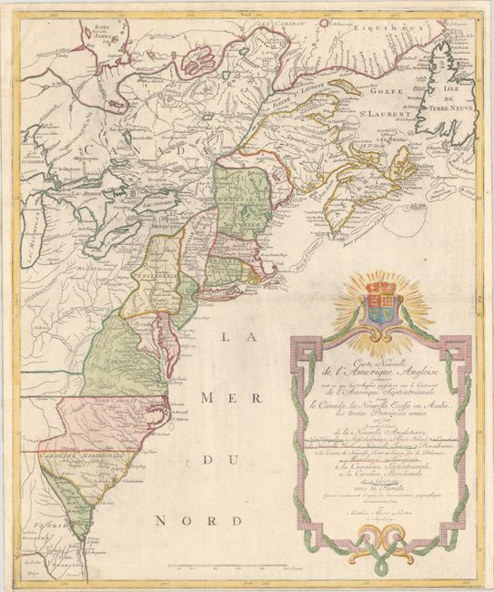
Auction 192, Lot 127
Subject: Colonial Eastern United States & Canada
Lotter, Mathias Albrecht
Carte Nouvelle de l'Amerique Angloise Contenant tout ce que les Anglois Possedent sur le Continent de l'Amerique Septentrionale Savoir le Canada, la Nouvelle Ecosse ou Acadie, les Treize Provinces Unies..., 1777
Size: 19.4 x 23.6 inches (49.3 x 59.9 cm)
Estimate: $1,000 - $1,300
Sold for: $750
Closed on 4/26/2023
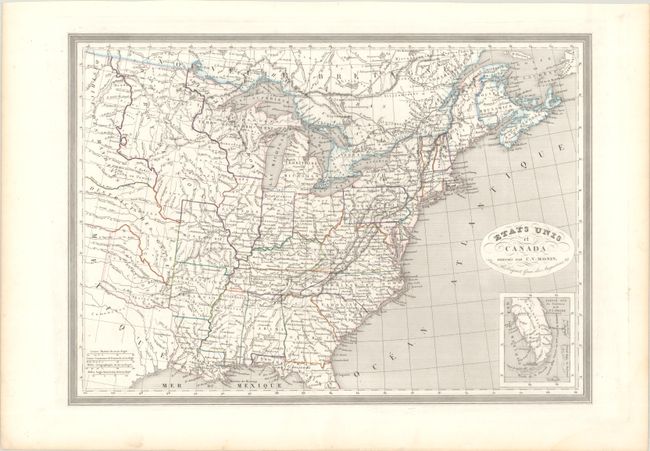
Auction 192, Lot 128
Subject: Eastern United States & Canada
Monin, Charles V.
Etats Unis et Canada, 1820
Size: 18 x 12.8 inches (45.7 x 32.5 cm)
Estimate: $140 - $170
Sold for: $100
Closed on 4/26/2023
Auction 192, Lot 129
Subject: Colonial Northeastern United States & Canada
Robert de Vaugondy, Didier
Carte des Pays Connus sous le Nom de Canada, dans Laquelle sont Distinguees les Possessions Francoises, & Angl?..., 1755
Size: 26.4 x 18.9 inches (67.1 x 48 cm)
Estimate: $2,300 - $2,750
A Separately Issued, French Political Propaganda Map at the Outset of the French & Indian War
Unsold
Closed on 4/26/2023
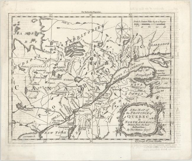
Auction 192, Lot 130
Subject: Colonial Northeastern United States & Canada
Kitchin, Thomas
A New Map of the Province of Quebec in North America; Drawn from the Best Authorities, 1764
Size: 8.6 x 6.8 inches (21.8 x 17.3 cm)
Estimate: $200 - $230
Sold for: $140
Closed on 4/26/2023
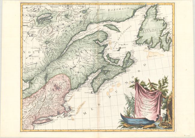
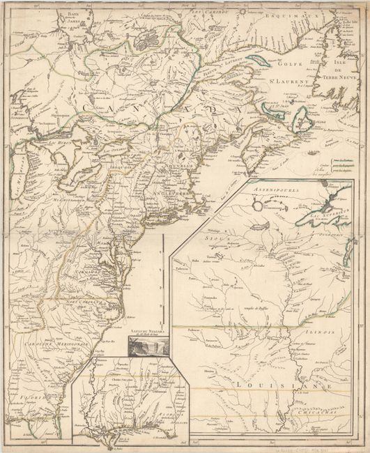
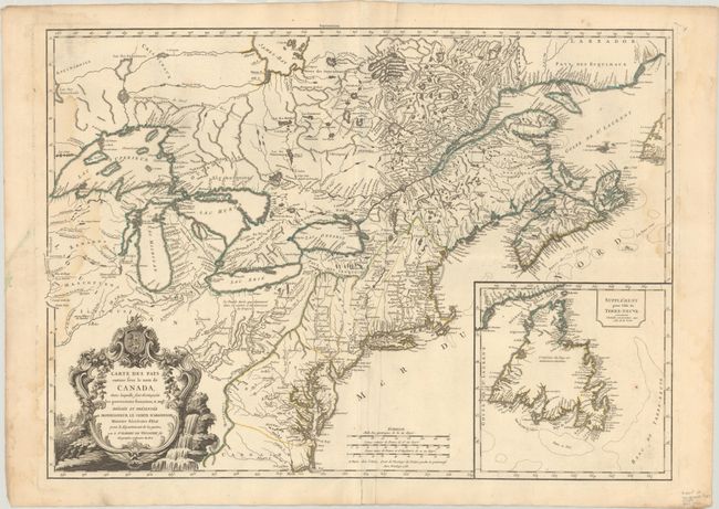
Auction 192, Lot 131
Subject: Colonial Northeastern United States & Canada
D'Anville/Santini
Partie Orientale du Canada, avec la Nouvelle Angleterre l'Acadie, et la Terre-Neuve, 1776
Size: 22.8 x 19.1 inches (57.9 x 48.5 cm)
Estimate: $475 - $600
Sold for: $500
Closed on 4/26/2023
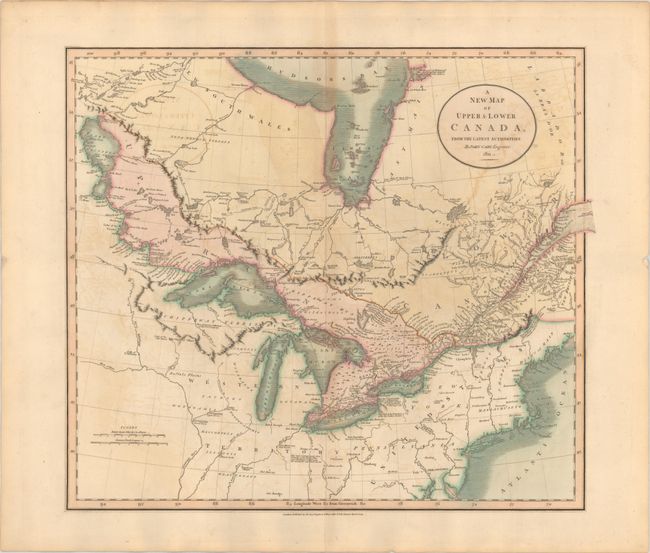
Auction 192, Lot 133
Subject: Northeastern United States & Canada
Cary, John
A New Map of Upper & Lower Canada, from the Latest Authorities, 1811
Size: 20.6 x 18 inches (52.3 x 45.7 cm)
Estimate: $350 - $425
Sold for: $250
Closed on 4/26/2023
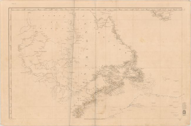
Auction 192, Lot 134
Subject: Northeastern United States & Canada
Direccion de Hidrografia
[Carta General del Oceano Atlantico Septentrional en Cuatro Hojas... - Northwestern Sheet] Hoja 3a. su Precio 13 Rs. Vn. En America 7 Rs. Pta. Fte., 1855
Size: 35.8 x 22.9 inches (90.9 x 58.2 cm)
Estimate: $300 - $400
NO RESERVE
Unsold
Closed on 4/26/2023
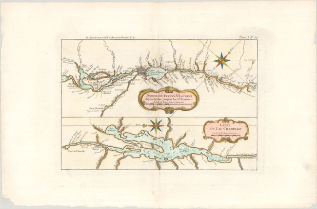
Auction 192, Lot 135
Subject: Lake Champlain & St. Lawrence River
Bellin, Jacques Nicolas
Partie du Fleuve St. Laurent Depuis Quebec Jusqu'au Lac St. Francois [on sheet with] Carte du Lac Champlain, 1764
Size: 12.4 x 8.3 inches (31.5 x 21.1 cm)
Estimate: $160 - $190
Sold for: $210
Closed on 4/26/2023
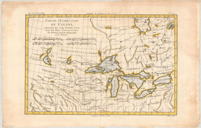
Auction 192, Lot 136
Subject: Colonial Great Lakes
Bonne, Rigobert
Partie Occidentale du Canada, Contenant les Cinq Grands Lacs, avec les Pays Circonvoisins, 1775
Size: 12.8 x 8.5 inches (32.5 x 21.6 cm)
Estimate: $200 - $230
Sold for: $325
Closed on 4/26/2023
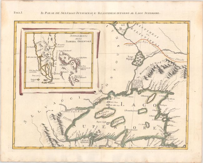
Auction 192, Lot 137
Subject: Colonial Great Lakes & Florida
Zatta, Antonio
Il Paese de Selvaggi Outauacesi, e Kilistinesi Intorno al Lago Superiore, 1780
Size: 16.6 x 12.1 inches (42.2 x 30.7 cm)
Estimate: $240 - $300
Sold for: $180
Closed on 4/26/2023
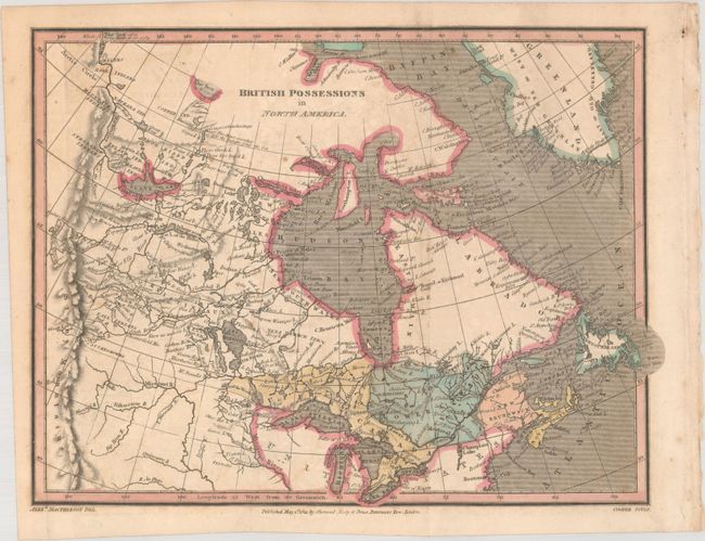
Auction 192, Lot 138
Subject: Northern United States & Canada
MacPherson, Alex.
British Possessions in North America, 1821
Size: 9.9 x 7.5 inches (25.1 x 19.1 cm)
Estimate: $110 - $140
Sold for: $60
Closed on 4/26/2023
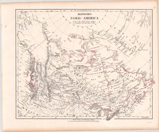
Auction 192, Lot 139
Subject: Northern United States & Canada
Flemming, Carl
[Lot of 3] Britisches Nord-America, 1844-50
Size: 15.8 x 12.6 inches (40.1 x 32 cm)
Estimate: $200 - $250
Set of 3 Oregon Boundary Maps
Sold for: $150
Closed on 4/26/2023
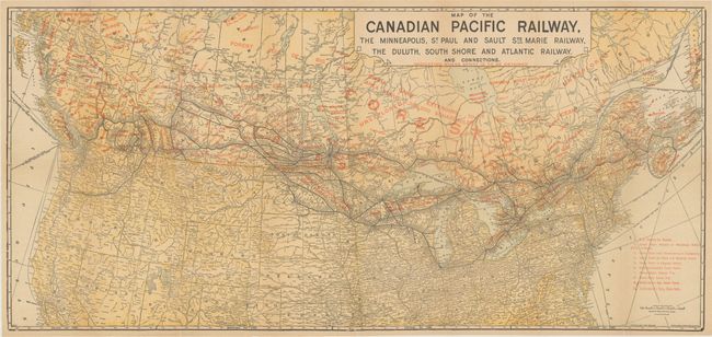
Auction 192, Lot 140
Subject: Northern United States & Canada
Poole Bros.
Map of the Canadian Pacific Railway, the Minneapolis, St. Paul and Sault Ste Marie Railway, the Duluth, South Shore and Atlantic Railway..., 1911
Size: 31.4 x 14.6 inches (79.8 x 37.1 cm)
Estimate: $140 - $170
Sold for: $100
Closed on 4/26/2023
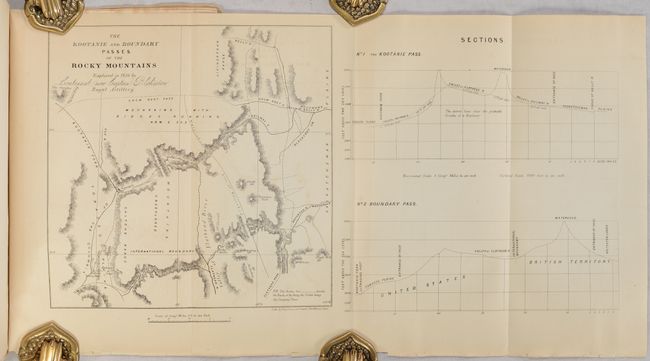
Auction 192, Lot 141
Subject: Northwestern Montana & Alberta, Canada
[Map in Report] The Kootanie and Boundary Passes of the Rocky Mountains Explored in 1858 by Lieutenant (now Captain) Blakiston Royal Artillery [in] The American Journal of Science and Art - Second Series. Vol. XXVII. - July, 1859 Nos. 82, 83, 84 , 1859
Size: 7.8 x 7.8 inches (19.8 x 19.8 cm)
Estimate: $150 - $180
Blakiston's Exploration of the Northern Rocky Mountains
Sold for: $100
Closed on 4/26/2023
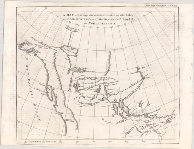
Auction 192, Lot 142
Subject: Western Canada & Alaska
Anon.
A Map Shewing the Communication of the Lakes and the Rivers Between Lake Superior and Slave Lake in North America, 1790
Size: 9.3 x 7.8 inches (23.6 x 19.8 cm)
Estimate: $240 - $300
Sold for: $180
Closed on 4/26/2023
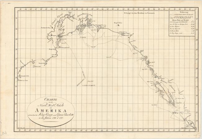
Auction 192, Lot 143
Subject: Western Canada & Alaska
Charte von der Nord-West Kuste von Amerika mit dem Laufe des King George u: der Queen Charlotte in den Jahren 1786 & 1787, 1791
Size: 17.4 x 11.8 inches (44.2 x 30 cm)
Estimate: $275 - $350
Unsold
Closed on 4/26/2023
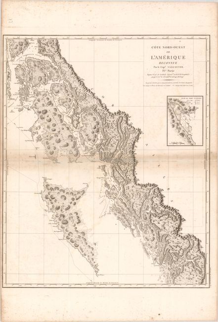
Auction 192, Lot 144
Subject: Western Canada & Alaska
Vancouver, George (Capt)
Cote Nord-Ouest de l'Amerique Reconnue par le Cape. Vancouver. IVe. Partie..., 1799
Size: 24.3 x 29.5 inches (61.7 x 74.9 cm)
Estimate: $500 - $650
Sold for: $450
Closed on 4/26/2023
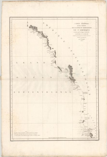
Auction 192, Lot 145
Subject: Western United States & Canada
La Perouse, Comte Jean F. Galoup, de
Carte Generale d'une Partie de la Cote du Nord-Ouest de l'Amerique Reconnue par les Fregates Francaises la Boussole et l'Astrolabe..., 1797
Size: 19.5 x 27.1 inches (49.5 x 68.8 cm)
Estimate: $180 - $210
Unsold
Closed on 4/26/2023
38 lots