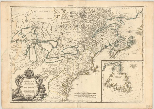
Subject: Colonial Northeastern United States & Canada
Period: 1755 (circa)
Publication:
Color: Hand Color
Size:
26.4 x 18.9 inches
67.1 x 48 cm
This rare, separately-issued map was published by Didier Robert de Vaugondy as political propaganda to simultaneously appease the Comte d'Argenson, the Minister of War, and snub the British and their claims in North America. D'Argenson, to whom the map is dedicated, was not only Louis XV's Minister of War, but was also responsible for overseeing the Royal Printing Works, the Royal Academy of Sciences, and the French book trade. He even became the arbiter of the lawsuits against Robert de Vaugondy's Atlas Universel in 1754, and was therefore a man of great importance to the publishing family.
This map was first published in August 1753, just 9 months before the beginning of the French and Indian War, a time during which the French and British colonial possessions in North America were still hotly contested. Maps were often used as a political tool to redraw boundaries and claim territory, and this map serves as a perfect example. In the Treaty of Utrecht (1713) Britain was to gain claims to Acadia and France would maintain the northern part of the territory, which reached up to the St. Lawrence River (now New Brunswick), but the dividing line between the regions was not specified within the treaty. The region continued to create controversy between Britain and France, and although the Treaty of Aix-la-Chapelle (1748) established a commission to resolve these competing claims, the area remained under dispute at the time this map was published. In his map, Didier Robert de Vaugondy decided that Acadie would only pertain to the southern coastline of the peninsula, giving the French the northern half of Nova Scotia and all of New Brunswick. His map was color-coded accordingly, with French claims outlined in blue and British claims in yellow.
This depiction angered the British, who assumed it was an official French publication due to the dedication to d'Argenson. In fact, Robert de Vaugondy's advertisement for the map asserted that it was based on information provided by the Ministry with the intent of clarifying claims in the peninsula. The map elicited such strong responses that Didier was forced to publish a retraction a month later in a weekly journal admitting that he had indeed not received official papers from the Ministry.
But Didier did not back down from his territorial claims, publishing a second state of the map depicting with the same boundaries in late 1755 or shortly thereafter, of which this map is an example. This second state added information south of Lake Erie concerning la Belle Riviere (Ohio River). Two important additions were made in the region that further taunted the British. The first was the location of the French Fort Duquesne, near present-day Pittsburgh, which had been completed in 1754. The second was the location of the British Fort Necessity, which is noted on the map as detruit, as it was destroyed by the French in 1755 after capturing it on 3 July 1754 during one of the first battles of the French and Indian War. The updates in the region were made based on a 1755 manuscript map of the Ohio River by the Depot de la Marine.
Also of note on this map is the large inset of Newfoundland. France ceded Newfoundland to Britain in the Treaty of Utrecht, but French fishermen retained rights to dry their catch on Newfoundland’s north shore, which is outlined in blue in the inset. The map is embellished with a superb rococo cartouche featuring the arms of the Comte d'Argenson, a waterfall and ships sailing along a coastline.
Possibly due to the controversy it created, this map was not included in the Atlas Universel and is rarely found on the market.
References: Kershaw #346; Pedley #458, pp. 69-74.
Condition: B
A sharp impression with contemporary outline color on a sheet with the watermark of a Maltese cross encircled in rosary beads. There are light dampstains entering the map at right and left, a small rust spot in the inset, and an extraneous crease adjacent to the centerfold.