Showing Featured Lots(remove filter)
Catalog Archive
51 lots
Page 1 of 2
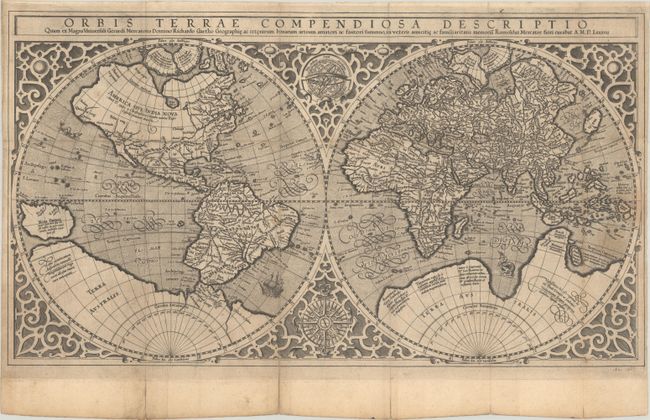
Auction 209, Lot 2
Subject: World
Mercator, Rumold
Orbis Terrae Compendiosa Descriptio quam ex Magna Universali Gerardi Mercatoris..., 1587
Size: 20.3 x 11.3 inches (51.6 x 28.7 cm)
Estimate: $4,500 - $5,500
Mercator's Double-Hemisphere World Map - A Rare Anonymous Variant
Sold for: $3,250
Closed on 6/17/2026
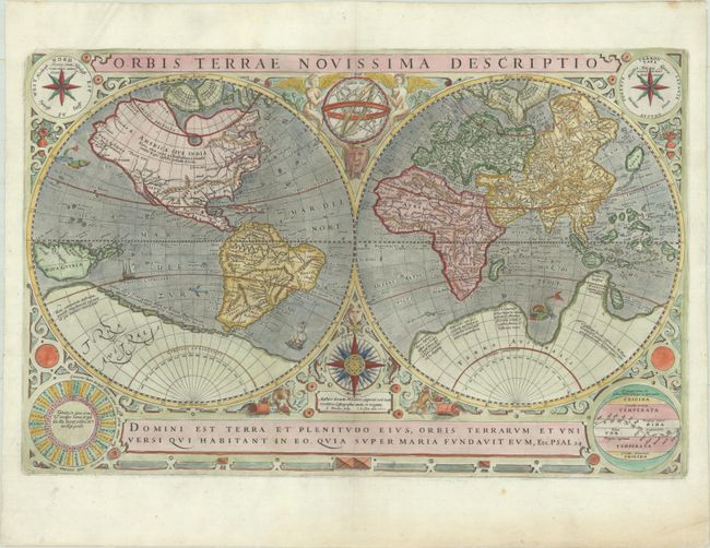
Auction 209, Lot 4
Subject: World
Hondius/Le Clerc
Orbis Terrae Novissima Descriptio, 1602
Size: 20.4 x 13.2 inches (51.8 x 33.5 cm)
Estimate: $4,750 - $6,000
Le Clerc's Decorative World Map Engraved by Hondius
Sold for: $3,000
Closed on 6/17/2026
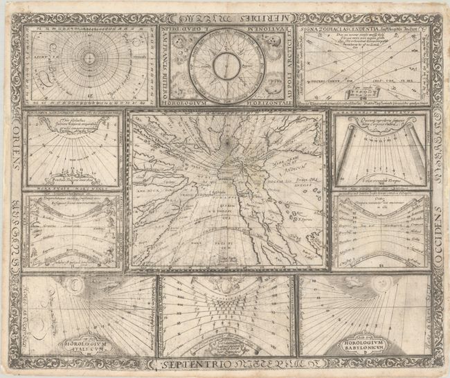
Auction 209, Lot 7
Subject: World
Ritter, Franz
[Untitled - World and Horological Diagrams], 1640
Size: 13.4 x 10.9 inches (34 x 27.7 cm)
Estimate: $2,750 - $3,500
Ritter's Unusual Sun-Dial World Map with Horological Diagrams
Unsold
Closed on 6/17/2026
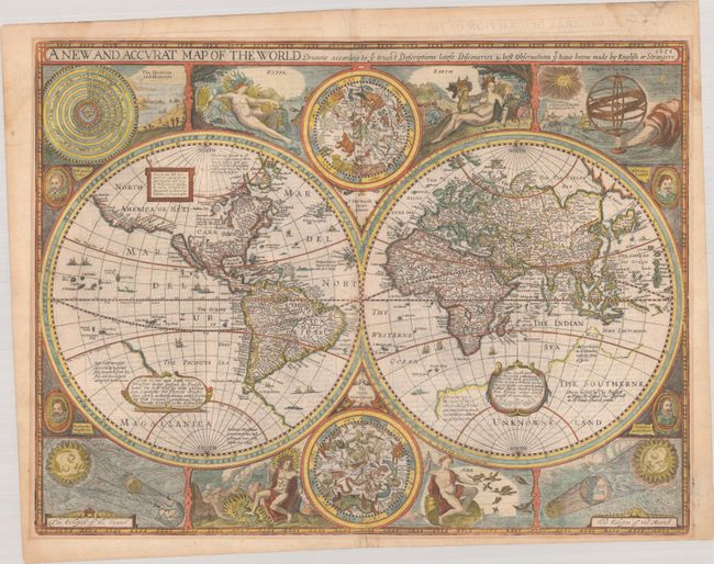
Auction 209, Lot 9
Subject: World
Speed, John
A New and Accurat Map of the World Drawne According to ye Truest Descriptions Latest Discoveries & Best Observations yt Have Beene Made by English or Strangers, 1651
Size: 20.6 x 15.6 inches (52.3 x 39.6 cm)
Estimate: $14,000 - $17,000
Speed's Double-Hemisphere World Map
Unsold
Closed on 6/17/2026
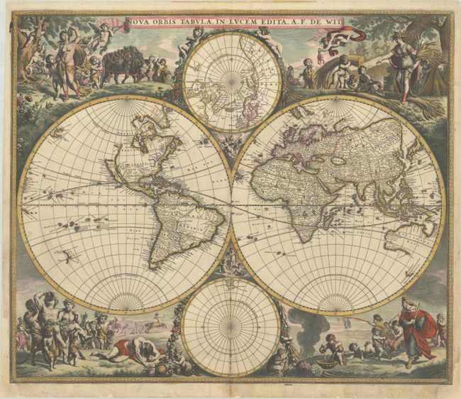
Auction 209, Lot 10
Subject: World
Wit, Frederick de
Nova Orbis Tabula, in Lucem Edita, 1680
Size: 22.3 x 18.9 inches (56.6 x 48 cm)
Estimate: $4,500 - $5,500
De Wit's Stunning Double-Hemisphere Map in Full Contemporary Color
Sold for: $3,250
Closed on 6/17/2026
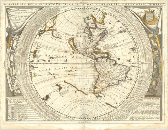
Auction 209, Lot 12
Subject: World
Coronelli, Vincenzo Maria
[Lot of 2] Planisfero del Mondo Nuovo... [and] Planisfero del Mondo Vecchio..., 1690
Size: 24.2 x 18 inches (61.5 x 45.7 cm)
Estimate: $3,000 - $3,750
Coronelli's Splendid Two-Sheet World Map
Unsold
Closed on 6/17/2026
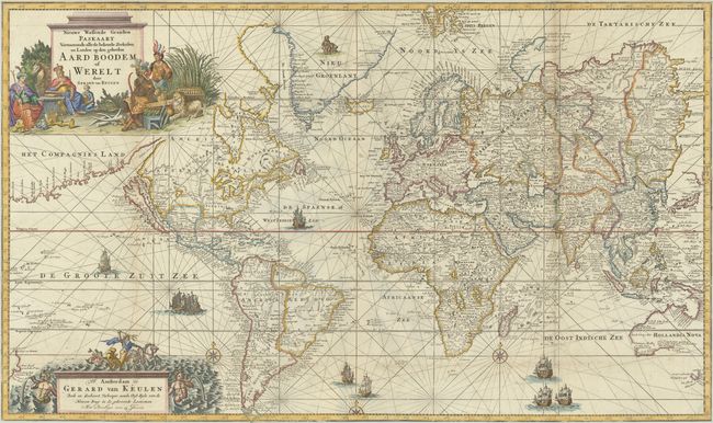
Auction 209, Lot 20
Subject: World
Keulen, Gerard van
Nieuwe Wassende Graaden Paskaart Vertoonende alle de Bekende Zeekusten en Landen op den Geheelen Aard Boodem of Werelt, 1728
Size: 39.4 x 23.4 inches (100.1 x 59.4 cm)
Estimate: $12,000 - $15,000
Spectacular Chart of the World Featuring California as an Island
Unsold
Closed on 6/17/2026
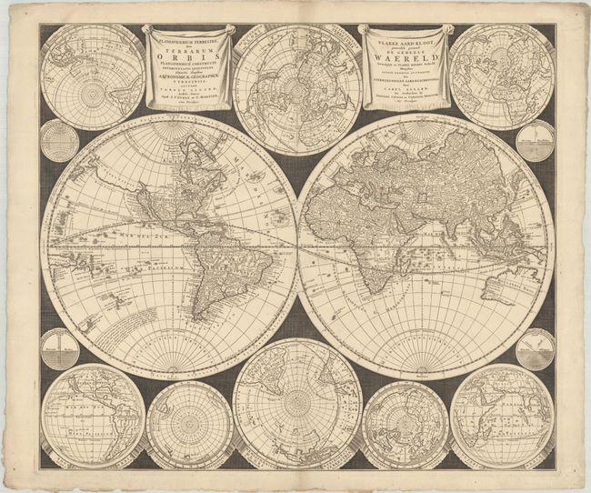
Auction 209, Lot 21
Subject: World
Allard/Covens & Mortier
Planisphaerium Terrestre, sive Terrarum Orbis... / Vlakke Aard-Kloot, Gemeenlyk Genaamd de Geheele Waereld..., 1730
Size: 23.6 x 20.4 inches (59.9 x 51.8 cm)
Estimate: $3,750 - $4,500
A Dramatically-Styled Map with a Focus on Scientific Information
Unsold
Closed on 6/17/2026
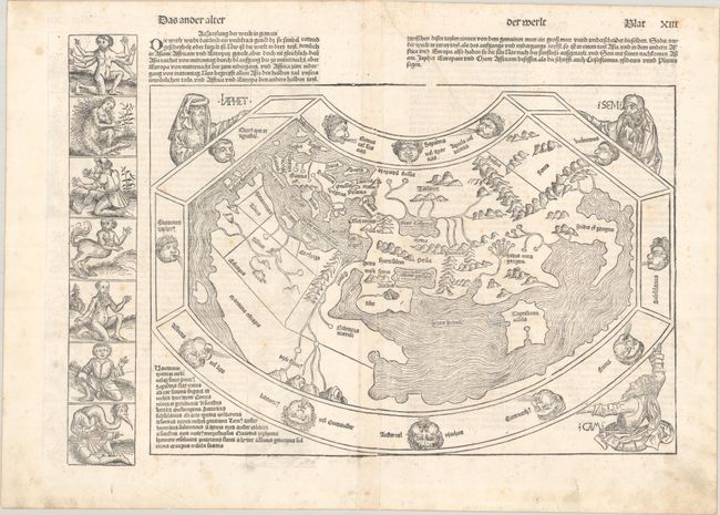
Auction 209, Lot 42
Subject: Ancient World
Schedel, Hartmann
Das Ander Alter der Werlt, 1493
Size: 20.1 x 14.3 inches (51.1 x 36.3 cm)
Estimate: $14,000 - $17,000
Schedel's Ancient World Map
Sold for: $10,000
Closed on 6/17/2026
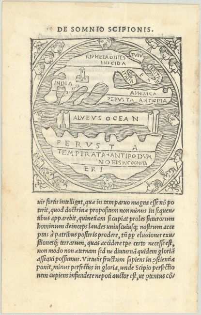
Auction 209, Lot 43
Subject: Ancient World
Macrobius, Ambrosius Aurelius Theodo
[Untitled - Ancient World], 1515
Size: 2.8 x 2.9 inches (7.1 x 7.4 cm)
Estimate: $800 - $950
Only Macrobius Map with Britain Attached to Europe
Sold for: $700
Closed on 6/17/2026
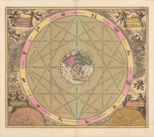
Auction 209, Lot 52
Subject: Celestial, California
Cellarius/Schenk & Valck
Typus Aspectuum, Oppositionum et Coniunctionum etz in Planetis, 1740
Size: 20.2 x 17 inches (51.3 x 43.2 cm)
Estimate: $1,100 - $1,400
Cellarius' Chart Showing the Island of California
Unsold
Closed on 6/17/2026
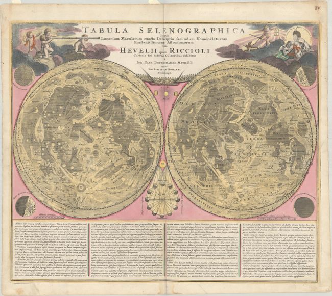
Auction 209, Lot 58
Subject: Moon
Doppelmayr/Homann
Tabula Selenographica in qua Lunarium Macularum Exacta Descriptio Secundum Nomenclaturam Praestantissimorum Astronomorum tam Hevelii quam Riccioli..., 1742
Size: 22.3 x 18.9 inches (56.6 x 48 cm)
Estimate: $1,000 - $1,300
Classic Decorative Moon Map Showing Competing Systems of Lunar Nomenclature
Sold for: $650
Closed on 6/17/2026
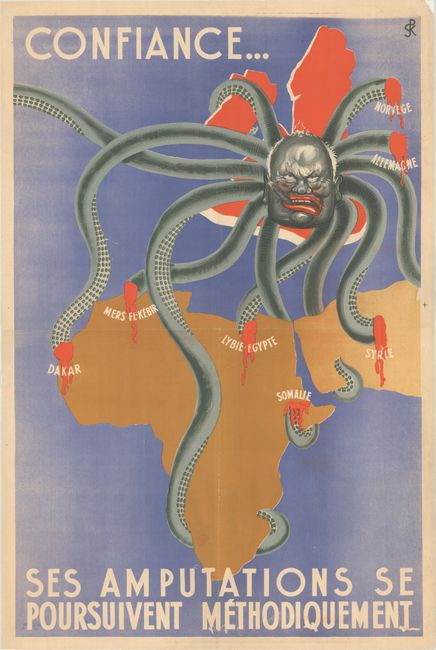
Auction 209, Lot 67
Subject: Cartographic Miscellany, World War II
Confiance... ses Amputations se Poursuivent Methodiquement, 1942
Size: 29.8 x 45.2 inches (75.7 x 114.8 cm)
Estimate: $1,500 - $1,800
Anti-British Propaganda Map with Churchill as an Octopus
Unsold
Closed on 6/17/2026
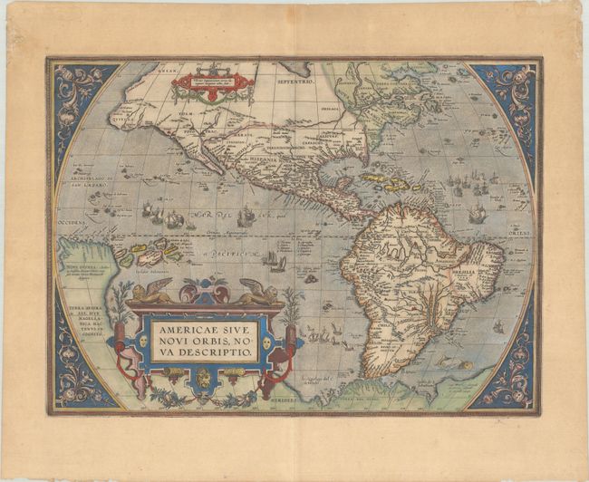
Auction 209, Lot 73
Subject: Western Hemisphere - America
Ortelius, Abraham
Americae sive Novi Orbis, Nova Descriptio, 1587
Size: 19.2 x 14 inches (48.8 x 35.6 cm)
Estimate: $4,750 - $6,000
Ortelius' Influential Map of the New World
Unsold
Closed on 6/17/2026
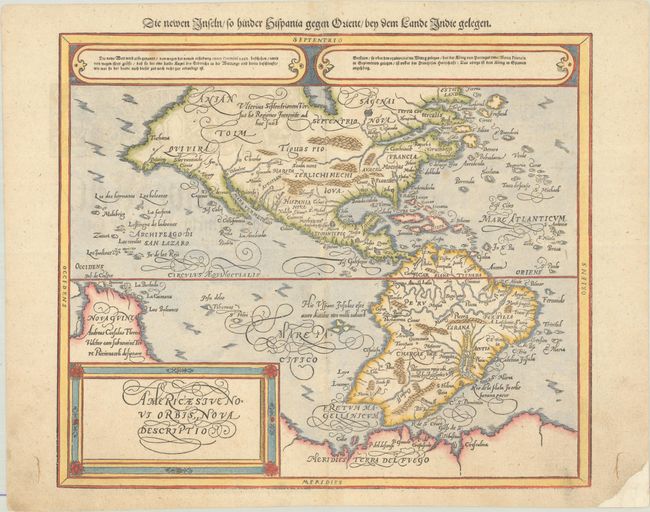
Auction 209, Lot 74
Subject: Western Hemisphere - America
Munster/Petri
Americae sive Novi Orbis, Nova Descriptio, 1614
Size: 14.2 x 12.1 inches (36.1 x 30.7 cm)
Estimate: $1,500 - $1,800
Munster's Take on Ortelius' Classic Map
Sold for: $1,100
Closed on 6/17/2026
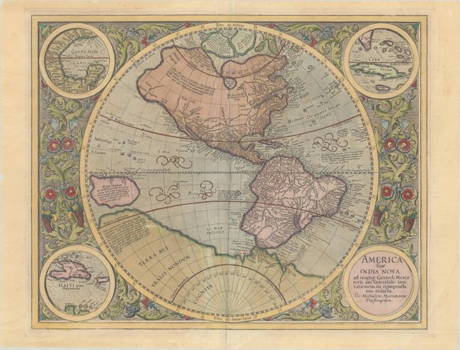
Auction 209, Lot 75
Subject: Western Hemisphere - America
Mercator, Michael
America sive India Nova, ad Magnae Gerardi Mercatoris aui Universalis Imitationem in Compendium Redacta, 1628
Size: 18.4 x 14.7 inches (46.7 x 37.3 cm)
Estimate: $2,400 - $3,000
Mercator's Foundation Map for the Americas in Contemporary Color
Sold for: $1,500
Closed on 6/17/2026
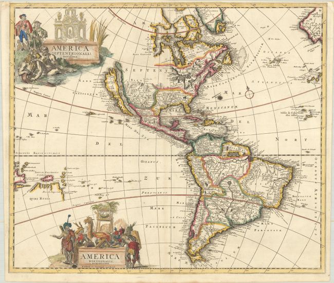
Auction 209, Lot 79
Subject: Western Hemisphere - America
Schenk, Pierre
America Septentrionalis, Novissima - America Meridionalis, Accuratissima, 1696
Size: 22.4 x 19.1 inches (56.9 x 48.5 cm)
Estimate: $1,200 - $1,500
Uncommon Map Featuring Two Figurative Title Cartouches
Sold for: $850
Closed on 6/17/2026
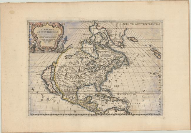
Auction 209, Lot 93
Subject: Colonial North America
Sanson/Rossi
L'America Settentrionale Nuovamente Corretta, et Accresciuta Secondo le Relationi piu Moderne..., 1715
Size: 21.4 x 15.4 inches (54.4 x 39.1 cm)
Estimate: $1,900 - $2,200
Italian Edition of Sanson's Seminal Map with Strait of Anian
Unsold
Closed on 6/17/2026
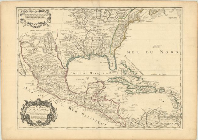
Auction 209, Lot 104
Subject: Colonial Eastern North America & West Indies
Delisle, Guillaume
Carte du Mexique et de la Floride des Terres Angloises et des Isles Antilles du Cours et des Environs de la Riviere de Mississipi..., 1703
Size: 25.5 x 18.8 inches (64.8 x 47.8 cm)
Estimate: $1,800 - $2,100
Landmark in American Cartography - First Printed Map to Accurately Depict the Mouth of the Mississippi River
Unsold
Closed on 6/17/2026
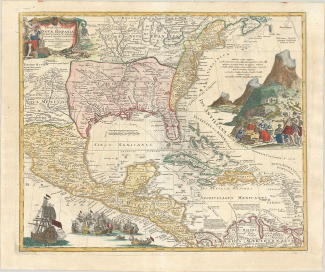
Auction 209, Lot 105
Subject: Colonial Eastern North America & West Indies
Homann, Johann Baptist
Regni Mexicani seu Novae Hispaniae, Ludovicianae, N. Angliae, Carolinae, Virginiae et Pensylvaniae, nec non Insularum Archipelagi Mexicani in America Septentrionali Accurata Tabula, 1718
Size: 22.7 x 18.9 inches (57.7 x 48 cm)
Estimate: $1,600 - $1,900
Homann's Decorative Map of Colonial America in the Era of the War of the Spanish Succession
Sold for: $1,200
Closed on 6/17/2026
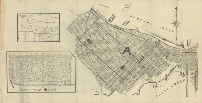
Auction 209, Lot 115
Subject: Vancouver, Canada
[4 Maps] T. Mathews' Vest Pocket Map of Vancouver, 1909
Size: 20.6 x 10.5 inches (52.3 x 26.7 cm)
Estimate: $550 - $700
Early Real Estate Plan of Vancouver
Unsold
Closed on 6/17/2026
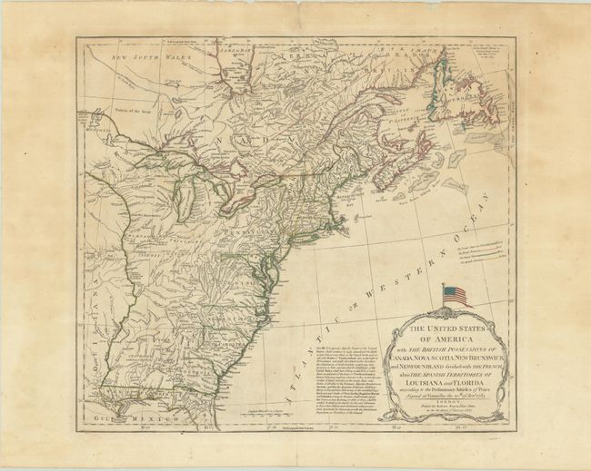
Auction 209, Lot 123
Subject: Eastern United States & Canada
Sayer, Robert
The United States of America with the British Possessions of Canada, Nova Scotia, New Brunswick and Newfoundland Divided with the French, Also the Spanish Territories of Louisiana and Florida..., 1790
Size: 20.3 x 18.2 inches (51.6 x 46.2 cm)
Estimate: $1,400 - $1,700
Celebrate 250 Years of Independence - This Map Features the Original Stars and Stripes
Sold for: $1,000
Closed on 6/17/2026
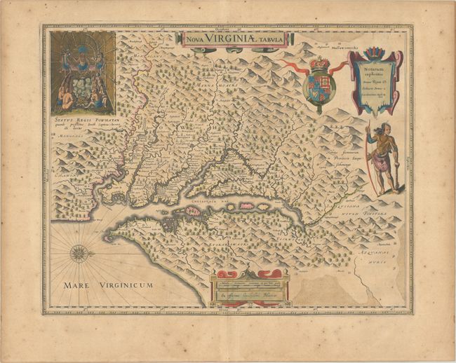
Auction 209, Lot 156
Subject: Colonial Mid-Atlantic United States
Hondius/Blaeu
Nova Virginiae Tabula, 1640
Size: 18.8 x 14.8 inches (47.8 x 37.6 cm)
Estimate: $1,600 - $1,900
One of the Most Important 17th Century Maps of the Chesapeake Bay
Sold for: $1,200
Closed on 6/17/2026
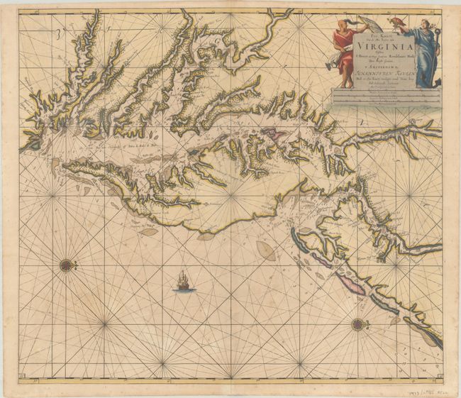
Auction 209, Lot 157
Subject: Colonial Mid-Atlantic United States, Chesapeake & Delaware Bays
Keulen, Johannes van
Pas Kaart van de Zee Kusten van Virginia Tusschen C Henry en t Hooge Land van Renselaars Hoek, 1695
Size: 22.6 x 20 inches (57.4 x 50.8 cm)
Estimate: $4,500 - $5,500
One of the Earliest Maps to Show Philadelphia
Unsold
Closed on 6/17/2026
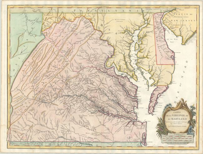
Auction 209, Lot 159
Subject: Mid-Atlantic United States
Robert de Vaugondy, Didier
Carte de la Virginie et du Maryland Dressee sur la Grande Carte Angloise de Mrs. Josue Fry et Pierre Jefferson, 1793
Size: 25.1 x 19 inches (63.8 x 48.3 cm)
Estimate: $1,400 - $1,700
An Essential Map of Virginia and Maryland
Sold for: $1,100
Closed on 6/17/2026
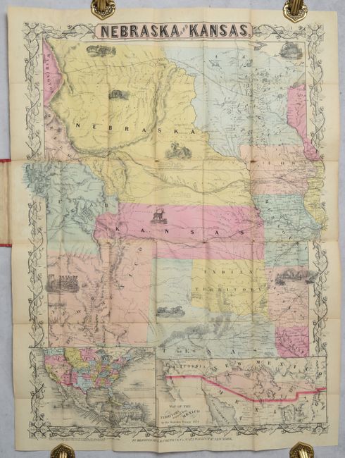
Auction 209, Lot 168
Subject: Central United States
Colton, Joseph Hutchins
Nebraska and Kansas, 1854
Size: 20.5 x 27.8 inches (52.1 x 70.6 cm)
Estimate: $5,500 - $7,000
The First Separate Map of Kansas & Nebraska Territories
Unsold
Closed on 6/17/2026
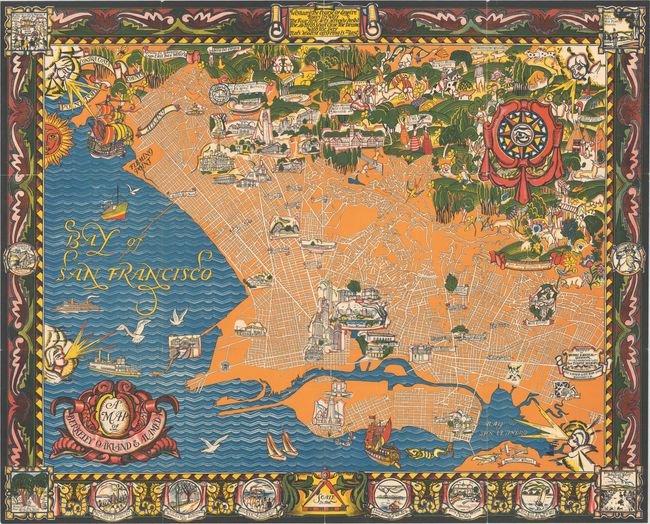
Auction 209, Lot 198
Subject: East Bay, California
A Map of Berkeley Oakland & Alameda, 1930
Size: 42.5 x 34.3 inches (108 x 87.1 cm)
Estimate: $1,100 - $1,400
"One of the Most Dramatic and Boldly Colored Pictorial Maps of the 1930s"
Sold for: $550
Closed on 6/17/2026
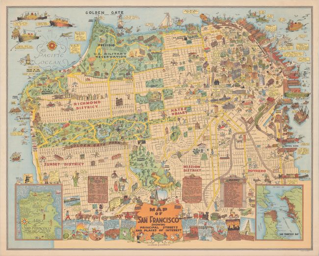
Auction 209, Lot 199
Subject: San Francisco, California
Map of San Francisco Showing Principal Streets and Places of Interest, 1927
Size: 32.4 x 25.9 inches (82.3 x 65.8 cm)
Estimate: $2,750 - $3,500
"One of the Most Ambitious of the Early Pictorial Maps"
Sold for: $2,000
Closed on 6/17/2026
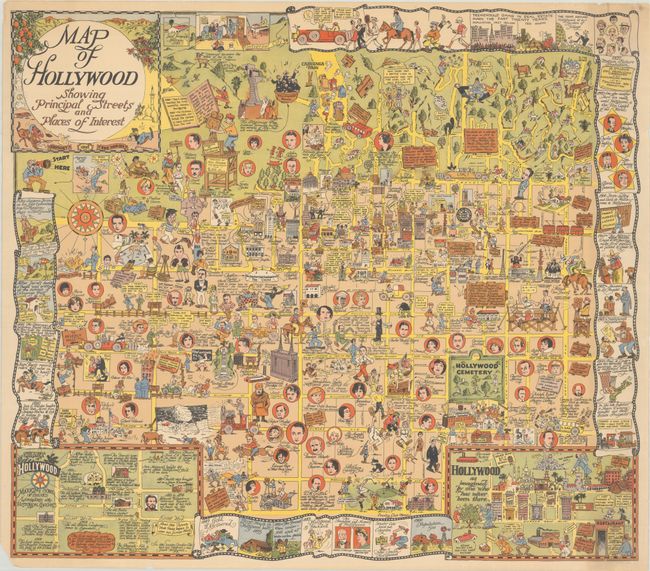
Auction 209, Lot 208
Subject: Hollywood, California
Map of Hollywood Showing Principal Streets and Places of Interest, 1928
Size: 26.5 x 23.6 inches (67.3 x 59.9 cm)
Estimate: $2,400 - $3,000
Rare Pictorial Map of Hollywood at the End of the Silent Era
Sold for: $1,800
Closed on 6/17/2026
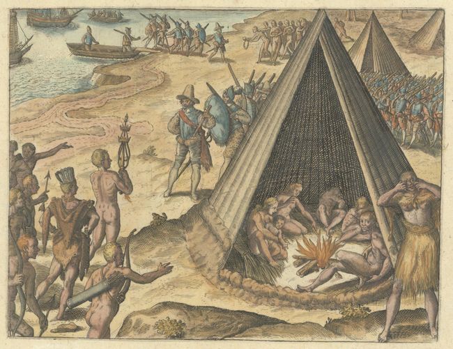
Auction 209, Lot 211
Subject: California, Natives
Bry, Theodore de
[Francis Drake Lands in California] Die Herr Franciscus Drake an ein Ort Tompt / alda ihn der Konig Desselben Orts / oder der Landtschafft / Besuchet, 1599
Size: 6.9 x 5.4 inches (17.5 x 13.7 cm)
Estimate: $350 - $425
De Bry's Scarce Engraving of Drake's Landing in New Albion
Sold for: $300
Closed on 6/17/2026
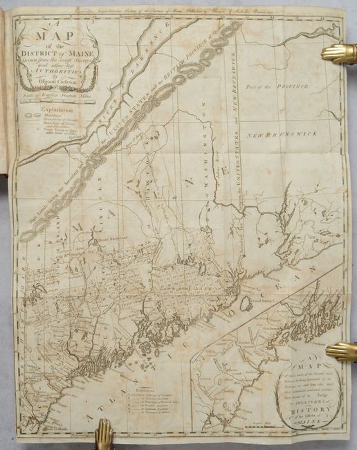
Auction 209, Lot 244
Subject: Maine
Carleton, Osgood
[Map in Book] A Map of the District of Maine, Drawn from the Latest Surveys and Other Best Authorities [in] The History of the District of Maine, 1795
Size: 16.4 x 20.4 inches (41.7 x 51.8 cm)
Estimate: $1,800 - $2,200
The Second Printed Map of Maine
Unsold
Closed on 6/17/2026
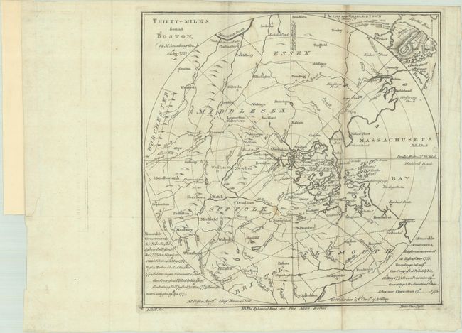
Auction 209, Lot 250
Subject: Boston, Massachusetts
Bell, Andrew
Thirty-Miles Round Boston, 1775
Size: 10.2 x 10 inches (25.9 x 25.4 cm)
Estimate: $2,000 - $2,300
One of the Earliest Maps of the Revolutionary War
Sold for: $1,250
Closed on 6/17/2026
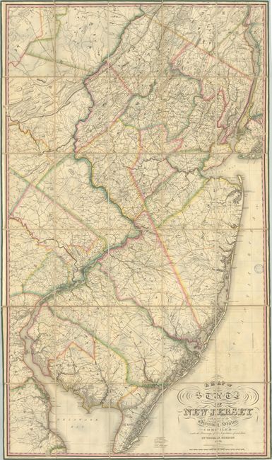
Auction 209, Lot 259
Subject: New Jersey
Gordon, Thomas F.
A Map of the State of New Jersey with Part of the Adjoining States Compiled Under the Patronage of the Legislature of Said State, 1828
Size: 32.6 x 56.7 inches (82.8 x 144 cm)
Estimate: $5,500 - $7,000
The First Official Map of New Jersey
Unsold
Closed on 6/17/2026
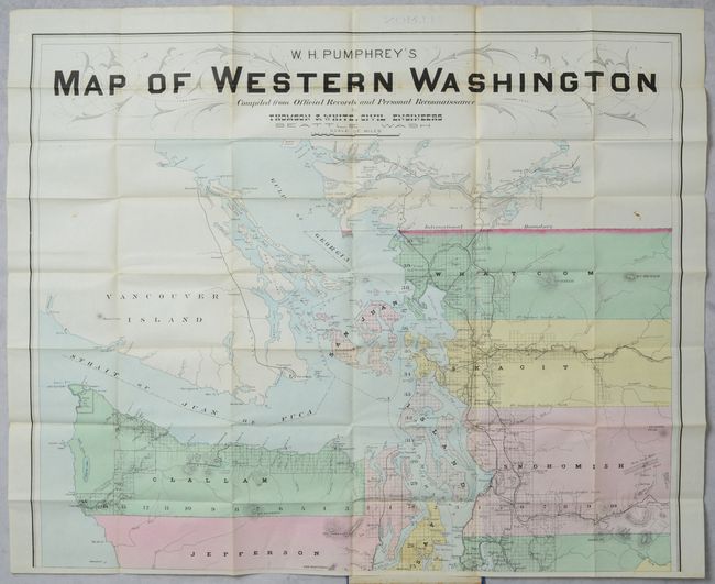
Auction 209, Lot 289
Subject: Washington
[On 2 Sheets] W.H. Pumhrey's Map of Western Washington Compiled from Official Records and Personal Reconnaissance, 1891
Size: 30 x 24.8 inches (76.2 x 63 cm)
Estimate: $1,800 - $2,200
Rare Map of the State in Contemporary Color Published Two Years After Statehood
Sold for: $2,100
Closed on 6/17/2026
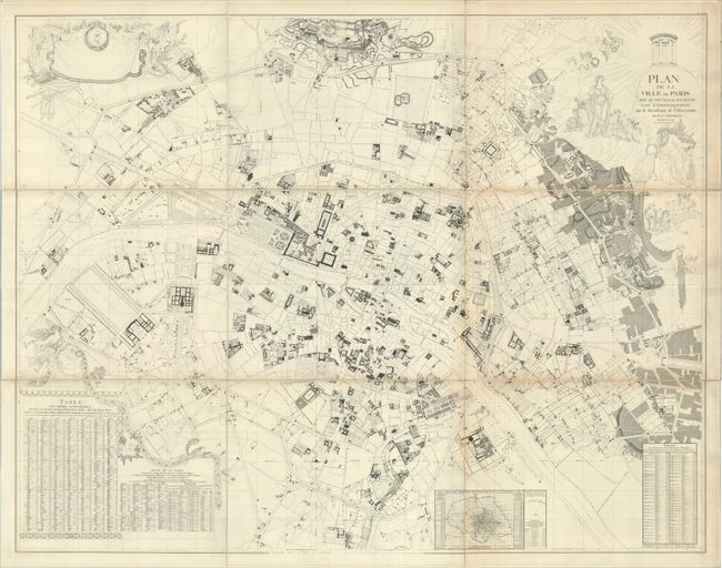
Auction 209, Lot 449
Subject: Paris, France
Plan de la Ville de Paris avec sa Nouvelle Enceinte Leve Geometriquement sur la Meridienne de l'Observatoire, 1791
Size: 71 x 55.5 inches (180.3 x 141 cm)
Estimate: $700 - $850
Mammoth Plan of Paris
Unsold
Closed on 6/17/2026
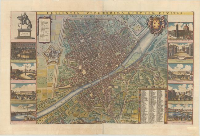
Auction 209, Lot 545
Subject: Florence, Italy
Wit, Frederick de
Florentia Pulcherrima Etruriae Civitas, 1695
Size: 28.2 x 17.4 inches (71.6 x 44.2 cm)
Estimate: $2,200 - $2,500
Spectacular View of Florence
Sold for: $1,600
Closed on 6/17/2026
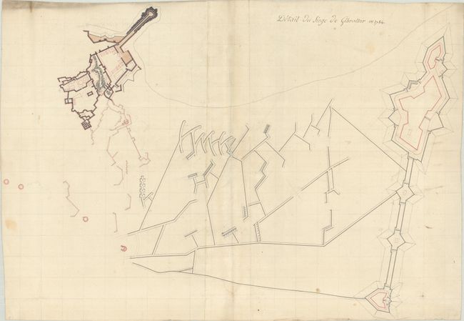
Auction 209, Lot 555
Subject: Gibraltar
Anon.
Detail du Siege de Gibraltar en 1784, 1785
Size: 25.8 x 18 inches (65.5 x 45.7 cm)
Estimate: $400 - $500
Manuscript Plan of the Fortifications During the Siege of Gibraltar
Sold for: $300
Closed on 6/17/2026
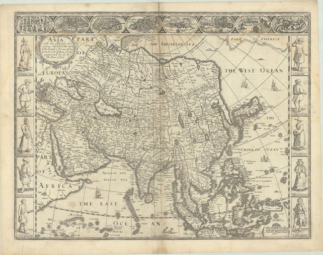
Auction 209, Lot 577
Subject: Asia
Speed, John
Asia with the Islands Adioyning Described, the Atire of the People, & Townes of Importance, All of Them Newly Augmented, 1626
Size: 20.4 x 15.6 inches (51.8 x 39.6 cm)
Estimate: $1,600 - $1,900
The First English Printed Map of Asia
Unsold
Closed on 6/17/2026
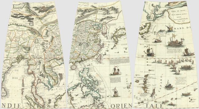
Auction 209, Lot 591
Subject: Eastern Asia
Coronelli, Vincenzo Maria
[Lot of 3 - Globes Gores] [Eastern China, Korea, Japan & the Philippines] [and] [Mainland Southeast Asia, Bangladesh, Eastern India & Sri Lanka] [and] [Japan, Tartari de Yupi, Terra de Iesso & the Mariana Islands], 1688
Size: 11.1 x 18.1 inches (28.2 x 46 cm)
Estimate: $5,500 - $7,000
Matching Set of 3 Stunning Coronelli Globe Gores of Eastern Asia
Sold for: $4,250
Closed on 6/17/2026
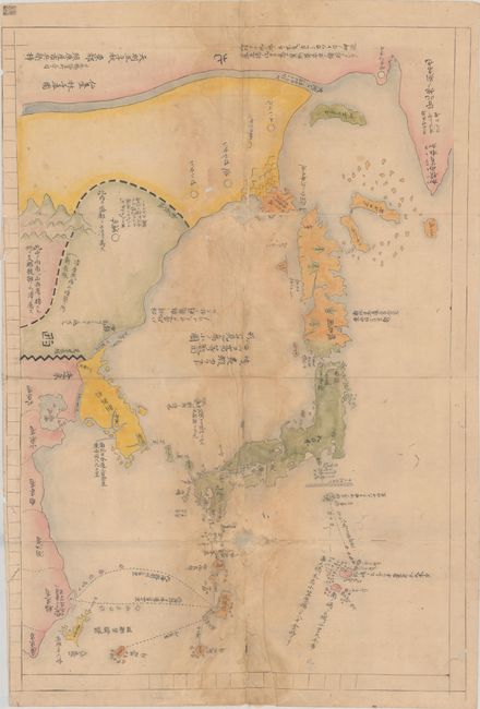
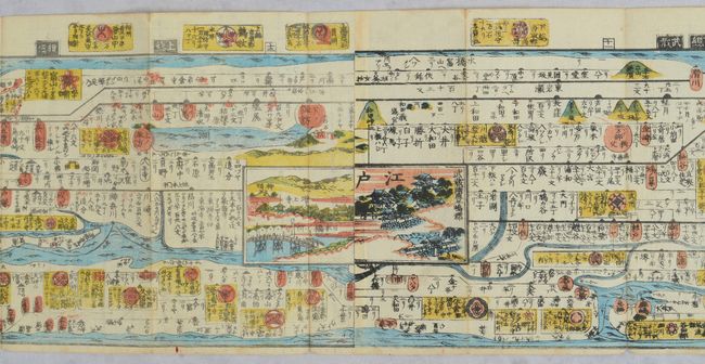
Auction 209, Lot 592
Subject: Eastern Asia, Japan
[Japanese Manuscript Map of the Three Kingdoms] Sangoku Tsuran Yochi Rotei Zenzu, 1792
Size: 19.9 x 28.8 inches (50.5 x 73.2 cm)
Estimate: $2,400 - $3,000
Manuscript Example of Controversial and Banned Map
Sold for: $1,100
Closed on 6/17/2026
Auction 209, Lot 601
Subject: Japan
[Japanese Strip Map of Japan] Kaisei Zōho Dochu Kotei Meisai, 1850
Size: 252.5 x 6.5 inches (641.4 x 16.5 cm)
Estimate: $750 - $900
Astounding 21-Foot-Long Woodblock Strip Map of Japan
Sold for: $500
Closed on 6/17/2026
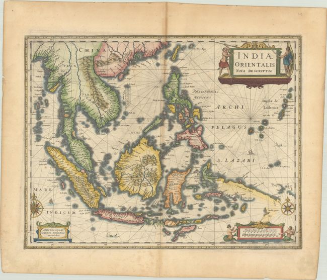
Auction 209, Lot 604
Subject: Southeast Asia
Jansson, Jan
Indiae Orientalis Nova Descriptio, 1638
Size: 19.9 x 15.4 inches (50.5 x 39.1 cm)
Estimate: $1,200 - $1,500
Includes Discoveries Made by the Dutch "Duyfken" Exploration
Sold for: $750
Closed on 6/17/2026
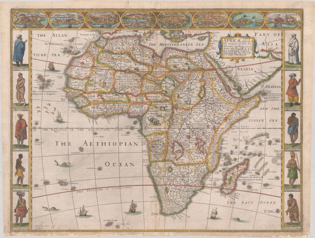
Auction 209, Lot 620
Subject: Africa
Speed, John
Africae, Described, the Manners of Their Habits, and Buildinge: Newly Done into English, 1676
Size: 20.2 x 15.5 inches (51.3 x 39.4 cm)
Estimate: $2,750 - $3,500
Speed's Carte-a-Figures Map of Africa
Sold for: $1,400
Closed on 6/17/2026
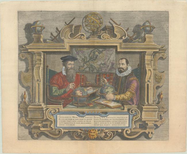
Auction 209, Lot 653
Subject: Portrait
Hondius
Gerardus Mercator... Iudocus Hondius..., 1613
Size: 17.4 x 15 inches (44.2 x 38.1 cm)
Estimate: $950 - $1,200
Famous Portraits of Mercator and Jodocus Hondius
Unsold
Closed on 6/17/2026
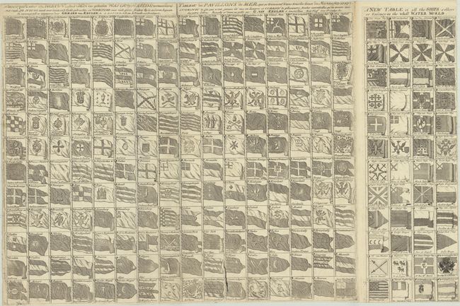
Auction 209, Lot 662
Subject: Prints - Ships, Flags
Keulen, Gerard van
Schouw-park Aller Scheeps-Vlaggen des Geheelen Water-Waerelds... / Tableau des Pavillons de Mer... / A New Table of All the Ships Collors or Ensings in the Wholl Water World, 1780
Size: 29.7 x 18.9 inches (75.4 x 48 cm)
Estimate: $1,400 - $1,700
Celebrate 250 Years of Independence - This Chart Features the Original Stars and Stripes
Unsold
Closed on 6/17/2026
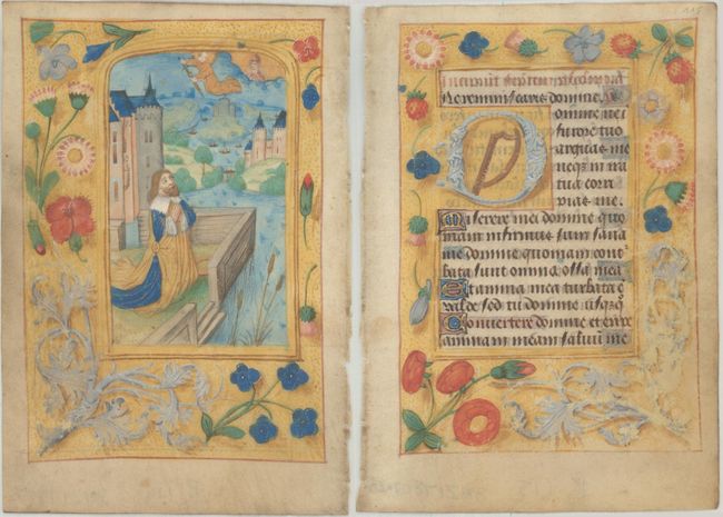
Auction 209, Lot 678
Subject: Medieval Manuscripts
Anon.
[Lot of 2 - Illuminated Leaves], 1490
Size: 3.8 x 5.4 inches (9.7 x 13.7 cm)
Estimate: $2,000 - $2,300
Features Hand-Colored Image of King David in Penitence
Sold for: $1,500
Closed on 6/17/2026
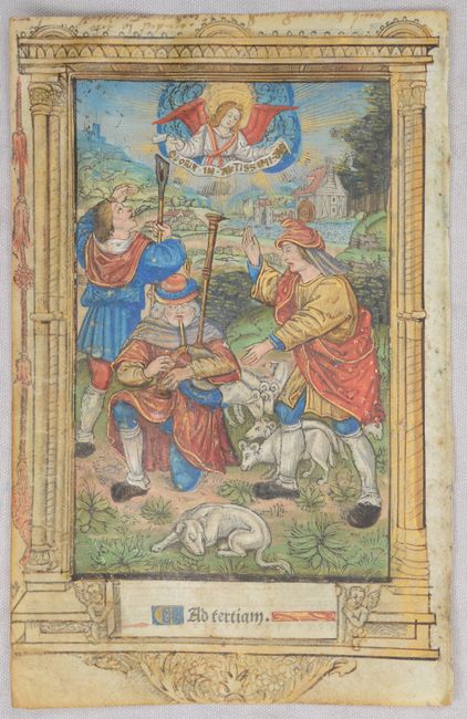
Auction 209, Lot 681
Subject: Early Printing
Vostre, Simon
[Illuminated Leaf], 1502
Size: 4.3 x 6.8 inches (10.9 x 17.3 cm)
Estimate: $800 - $950
Superb Hand-Colored Image of the Annunciation to the Shepherds
Sold for: $600
Closed on 6/17/2026
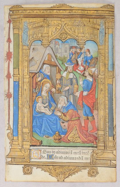
Auction 209, Lot 682
Subject: Early Printing
Vostre, Simon
[Illuminated Leaf], 1502
Size: 4.3 x 6.7 inches (10.9 x 17 cm)
Estimate: $800 - $950
Superb Hand-Colored Image of the Adoration of the Magi
Sold for: $600
Closed on 6/17/2026
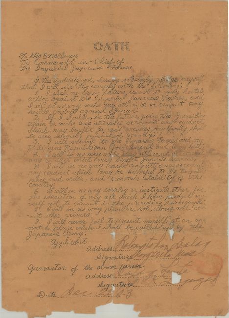
Auction 209, Lot 693
Subject: Document - Philippines, Japan, World War II
[Signed Oath to the Commander-in-Chief of the Imperial Japanese Forces], 1943
Size: 7.3 x 10.2 inches (18.5 x 25.9 cm)
Estimate: $400 - $600
Tool to Suppress the Filipino Resistance
Sold for: $200
Closed on 6/17/2026

Auction 209, Lot 695
Subject: Atlases
Schreiber, Johann Georg
Atlas Selectus von Allen Konigreichen und Landern der Welt..., 1749
Size: 6.4 x 8.3 inches (16.3 x 21.1 cm)
Estimate: $2,400 - $3,000
Petite Atlas with 42 Maps in Full Original Color
Sold for: $2,100
Closed on 6/17/2026
51 lots
Page 1 of 2