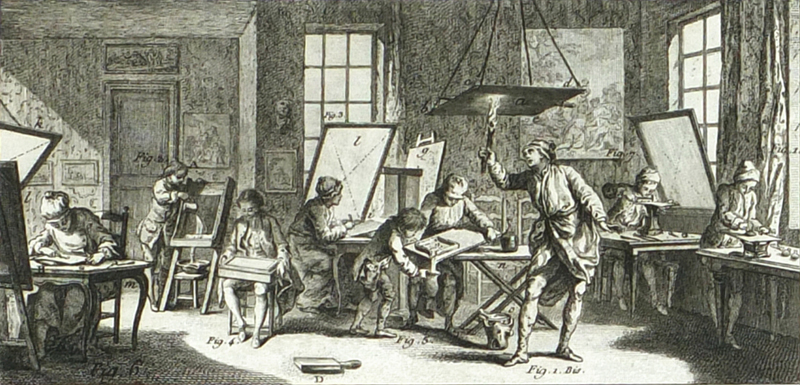
An illustration of a copperplate engraving workshop. From Diderot’s Encyclopédie, Recueil des Planches, circa 1768. (Image courtesy of Antikvariat Krenek)
A Primer on European Printing & Papermaking from the 15th to 19th Centuries
by Eliane Dotson
This article focuses on the basics of printing and papermaking for maps, and how they evolved over the centuries. While these are both complicated subjects, about which hundreds of books and articles have been written, the goal of this article is to give a broad overview of the topics as they relate to printed antiquarian maps. Understanding how maps were printed and what types of paper were used over the centuries are key building blocks to other important topics regarding antique maps. For instance, in order to identify the difference between an original engraving and a reproduction, one must be able to recognize the key characteristics of different printing methods and know what type of paper to expect for maps from different time periods. In addition, understanding how maps were printed will help in discerning between “states” and “editions” of maps, which can directly impact value. This article provides a foundation on European printing and papermaking from the fifteenth to nineteenth centuries to make the world of antique maps a little less mysterious.
Three Key Printing Methods for Maps
A few decades after the invention of the moveable-type printing press by Johannes Gutenberg circa 1450, printed maps began appearing on the market in Europe. (Maps that were not printed and were drawn individually by hand are called manuscript maps, and these represent a very small percentage of the maps available on the market.) The first maps were made using either wood blocks or copperplates, and other types of printing surfaces were used in later centuries. It is important to note that there are different types of printing surfaces, each of which lend themselves to a specific type of printing method. There were three main types of printing methods that were used over the centuries: relief, intaglio, and planographic. Although some of the very first maps were printed using the intaglio printing method on copperplates, woodblocks, which utilized the relief printing method, were the primary form of printed maps in the fifteenth and early sixteenth centuries. This is likely due to several factors. One reason was that Gutenberg’s moveable-type printing was also a relief printing process that used a screw press, which was also suitable for woodblocks. Copperplates required a rolling press, which was not as common until the sixteenth century. In addition, wood was a less expensive material than copper, and there was a long tradition of wood carving in Europe and, therefore, many skilled craftsmen in the trade.
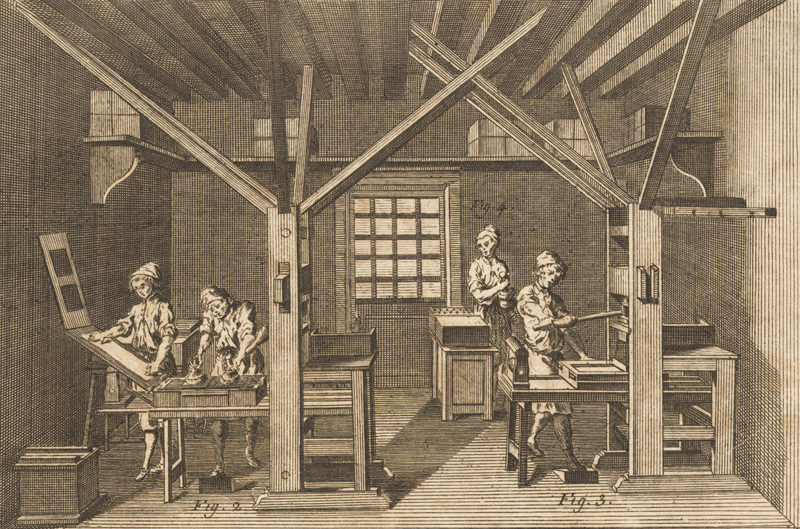
This illustration depicts printing presses for moveable-type, which could be adapted for woodblocks. From Diderot’s Encyclopédie, Recueil des Planches, circa 1767.
With relief printing, a woodblock (and later soft metal) was used and all of the areas that were not to be printed were cut away, leaving raised lines (similar to a modern-day rubber stamp). Once a woodblock has been carved it is known as a woodcut. The raised surfaces of the woodcut were inked and pressed onto paper, so that the resulting print would have black inked lines on a white background, and the printed areas would leave a slight indentation in the paper. (Woodcuts are sometimes mistakenly called wood engravings, which are actually a different relief method. With wood engravings, the lines and text are engraved into the woodblock, so they present the opposite effect as a woodcut, with white lines on a black inked background.) Due to the types of tools that are used in woodcuts, and the nature of wood itself, woodcuts create lines that are more angular and squarer, with blunt (rather than tapered) ends.
There were various methods used for adding text to woodcut maps. One was to cut the letters directly into the woodblock, which resulted in crude and uneven letters. Another option was to print the map with two separate impressions, first with the map using a woodcut and then a second pass with moveable type. This method is evidenced by type that overlaps the map image, or is printed slightly askew from the image. A third method was to chisel holes into the woodblock to insert text from tiny metal plates, however this technique was not ideal if there were too many scattered place names on the map, as it would weaken the woodblock and could cause it to warp or split.
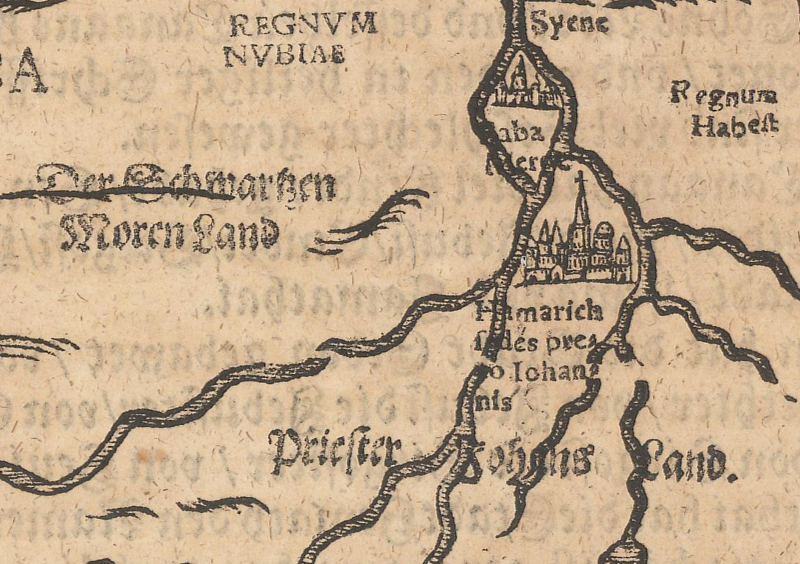
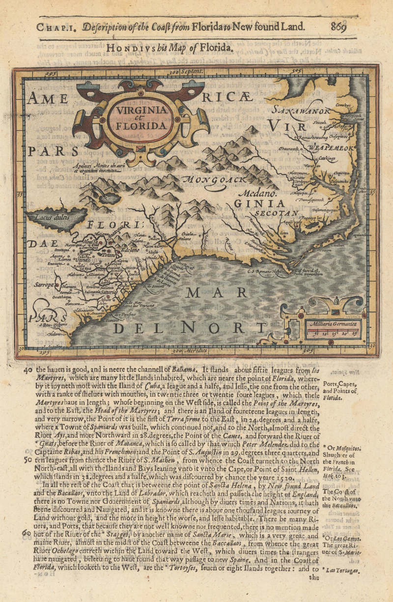
On Heinrich Bunting’s map of Africa, the type was printed separately from the woodcut map, occasionally overlapping.
One of the limitations of using woodblocks was in making changes, whether to correct an error or to update it based on new information. When moveable type was used for the lettering, text could be updated fairly easily. We see this with mapmakers such as Sebastian Munster, who printed the text separately from the woodcut maps, and therefore could use the same woodcut map with text in different languages for different editions. However, when changes had to be made to the map itself, either a portion of the woodblock had to be cut out and replaced with a new piece of wood, or an entirely new woodblock had to be cut. Because of the limitations of woodblock printing, most mapmaking shifted to intaglio printing on copperplates by the end of the sixteenth century. Regardless, there were many important mapmakers that employed relief printing, such as Hartmann Schedel, Martin Waldseemuller, Lorenz Fries, Sebastian Munster, and Benedetto Bordone.
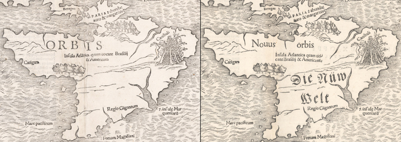
These side-by-side examples of two different editions of Sebastian Munster’s map of the Americas demonstrate how text in various languages could be added separately to the woodcut maps for editions of his Cosmographia.
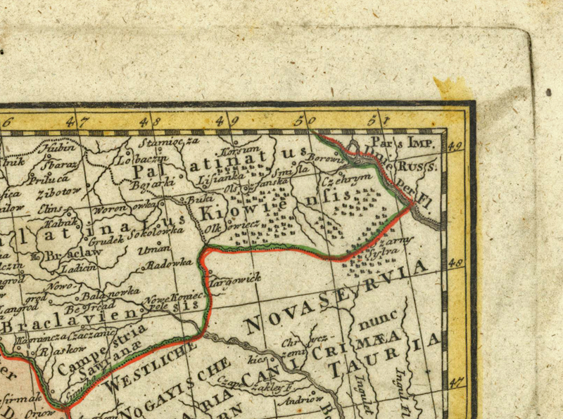
The intaglio method, which includes line engraving, etching, aquatint, and mezzotint, used soft metal such as copper or steel. In mapmaking, copper was the preferred type of metal until steel engraving was introduced in the late eighteenth century, and line engraving was the most common intaglio method used. The engraving process is somewhat opposite that of the relief method, since the image was cut into the metal and ink was rubbed into the engraved areas and cleaned off of the flat surface. When printed onto paper, the ink remained raised on the paper and the edge of the plate created a platemark that was indented into the paper. Because of the high cost of copper, the plates were cut as small as possible to fit an engraving, and therefore, the platemarks on early maps were typically only several millimeters from the edge of the engraving. However, by the mid-eighteenth century, some mapmakers were less frugal with their copper, and wider platemarks can be found.
Printer’s ink is visible along the edge of the platemark on this 1642 map of Cyprus by Willem Blaeu, showing how the copperplates were cut to fit engravings as closely as possible.
This 1766 map by Homann Heirs has a much wider platemark.
Printing on copperplates had several advantages over printing on woodblocks. First, copperplates could be made larger than woodblocks, allowing larger maps to be produced. Second, the tools used in intaglio engraving allowed for more precise lines, minute detail, and text to easily be engraved into the plate. And third, the process of making changes to metal plates was much simpler, allowing for multiple rounds of changes to be made to a single plate.
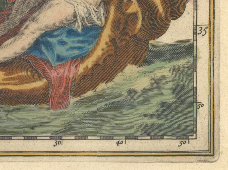
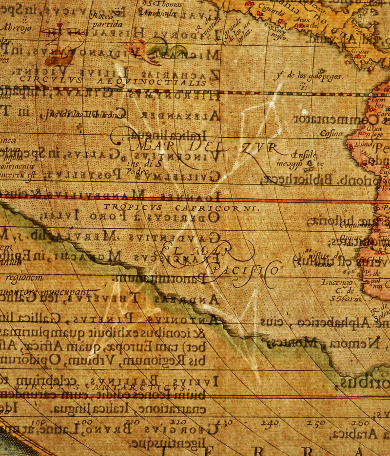
This sixteenth century map published by Abraham Ortelius illustrates the consistency of lines produced with copperplate engravings: crisp, distinct, continuous, and with pointed ends.
One of the tell-tale signs of intaglio printing is that it produces lines that are crisp, distinct and continuous. With line engraving, the engraver can make lines of varying thicknesses, and the end of lines are typically pointed, rather than blunt (such as with woodcuts) or rounded (such as in etching). In order to make changes to a plate, the engraved lines can be rubbed with a burnisher, which spreads the copper into the lines, or for deeper lines, the plate can be hammered from the back. Signs of these erasures to a plate can be visible in subsequent printings and can help identify in what order changes were made to a plate.
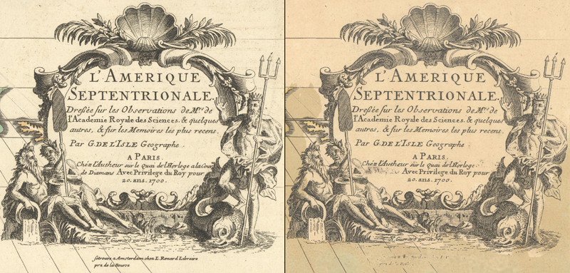
Signs of erasures are visible on two examples printed from the same copperplate, both within the publisher’s imprint (below “A Paris”) as well as beneath the cartouche itself.
However, there were also some drawbacks to line engraving and intaglio printing. It was a slow, painstaking process, in which a skilled engraver might only complete about 1 square inch of engraving per day. In addition, it was costly, both for the copper itself, and for the labor required to prepare and engrave the plate. The life of a single copperplate was finite and depended on various factors, including the quality of the copper, how well the plate was prepared, the depth of the engraved lines, the number of changes to the plate that were made over time, and how the plate was handled during the printing process. Although there are some estimates of over 8,000 impressions being pulled from a single copperplate, such as with Abraham Ortelius’ map of Africa, records from the Ordnance Survey state that only “about 500 good impressions” could be made from their copperplates. Another limiting factor was that intaglio printing required a rolling press, which was different from the common printing press used for letterpress and woodcuts. Therefore, if both a copperplate map and letterpress text needed to appear on the same page, the page would have to be printed twice with two different types of presses.
In Samuel Purchas’ Purchas His Pilgimes (1625), copperplate maps were printed on pages with letterpress text, requiring two different printing presses.
Some of the most beautiful and decorative maps ever produced were copperplate maps. For over 200 years, copperplate intaglio printing was the predominant method used for maps in Europe, and the well-known masters of the Golden Age of cartography created copperplate engravings, including Abraham Ortelius, Gerard Mercator, Jodocus Hondius, Willem Blaeu, and many others.
The planographic method was invented in 1796 by Alois Senefelder and is most commonly known as lithography. In this method, an image is drawn onto a smooth surface, such as limestone or metal, with a wax or grease crayon. The surface is then wetted and the wax or grease image repels the water, and when ink is applied, the ink only adheres to the lines drawn, not to the wet surface. Once paper is pressed onto the inked surface, the ink transfers to the paper. As a result, both the paper and ink remain flat.
An example of lithography (with hand coloring) from Philippe Marie Guillaume Vandermaelen’s Atlas Universel, published in 1825-27.
Senefelder spent two decades experimenting with lithography and perfecting the process, and it wasn’t until after he published a book on his discoveries in 1818-19 that the medium began to gain popularity among map publishers. Because lithography allowed maps to be drawn onto a flat surface, practically any artist could prepare a lithograph, and the specially-skilled woodcutters and engravers of relief and intaglio printing were not required. This method permitted a more natural drawing style and enabled plates to be prepared much more quickly than previous printing methods. Changes were also easy to make, as the plates could simply be wiped clean and redrawn. In addition, Senefelder developed the transfer method, in which a right-facing image was drawn onto specially prepared paper, which was then transferred to the stone or metal surface, and finally printed onto paper. Because the image was transferred, and therefore inverted, twice, it could be drawn normally, rather than as a mirror-image as with relief and intaglio printing.
However, lithography required specialized presses, which slowed its growth in the early part of the nineteenth century. Another disadvantage to the early lithographic process is that it required the use of limestone or similar stone, which were heavy to move and difficult to store. Once printers switched from using stone to using lightweight and pliable zinc plates, which could be rolled around a cylinder, printing lithographs became even faster and less expensive.
One of the important features of lithography is that it lent itself to printing in color. The image would be drawn on multiple stones or plates, with each one representing one color, which would then be printed in succession on a sheet of paper. The individual stones or plates would be aligned using either pins in the corners or registration guards. This method was known as chromolithography, and was tested in Germany and France in the 1830s and 1840s, but was not prevalent until later in the century.
Published circa 1845, this is an early example of chromolithography published in August Nicolas Vaillant’s Voyage Autour du Monde.
While both relief and intaglio printing continued in the nineteenth century, planographic printing became the primary method employed. Lithography is commonly found in nineteenth century atlases, military maps, nautical charts, and educational maps, and was a springboard for great innovations in printing that occurred in the nineteenth and twentieth centuries (that are outside of the scope of this article).
The Evolution of Paper
Just as printing underwent major changes between the fifteenth and nineteenth centuries, so did papermaking. In fact, both printing and papermaking experienced similar trajectories for their innovations, which remained stagnant for hundreds of years and then accelerated during the Industrial Revolution. There were three main types of paper that were used for maps over the centuries: handmade laid paper, wove paper, and wood pulp paper.
Until the late 18th century, the vast majority of maps were printed on handmade laid paper, which was invented in ancient China and spread to Europe in the twelfth century. By the fourteenth century, paper production existed all over Europe, however it increased significantly after the invention of Gutenberg’s printing press. At this time, paper was made from linen and cotton rags, which were collected from used white rags. Linen and cotton were ideal substances to make paper as they primarily consist of cellulose fibers, which offer strength, durability and flexibility. At times when white rags weren’t available, other types of materials were used, such as colored rags, sailcloth, rope, and damaged books, resulting in inferior paper, often brownish or greyish in color. The paper was made on a mesh wire tray with wires laid closely together horizontally about 1 millimeter apart and additional wires laid vertically about 2-3 centimeters apart. As a result, the mold created lines in the paper known as laid lines (horizontally) and chain lines (vertically), which are visible if you hold a sheet of laid paper up to light. A removable, narrow rim, known as a “deckle,” was fitted around the mold to prevent the paper fibers from flowing over the sides of the mold. The deckle determined the size of the paper and also contributed to the edges of the paper being slightly irregular, called “deckle edges,” which were often trimmed away to create straight edges.
This piece of handmade laid paper shows the laid lines, chain lines, and inconsistencies inherent in this type of paper.
Because of the raw material used and the handmade process, it resulted in paper that was sturdy due to its long, intertwined fibers, had a slightly textured surface, and often included small imperfections. These imperfections included small foreign particles that intermingled in the paper pulp, as well as round, lighter-colored, dime-sized spots caused by water droplets falling onto a newly-made sheet. The color of the paper was determined by the raw materials used and the clarity of the water available in the paper mill. Bleaching of paper was not in practice until the nineteenth century, although in the eighteenth century some French papermakers would add blue dye to mask any discoloration of the paper.
Often shapes and names were added to the mesh wire trays to create watermarks that identified the paper mill. The watermarks were added either in the center of the sheet or, more commonly, two watermarks were added in the middle of each half-sheet. Certain watermarks are attributable to specific time periods or map publishers and can help date a piece of paper and identify its source. One such example is with Abraham Ortelius’ maps, which most commonly bear one of three watermarks (crossed arrows, a shield with a horn, or the coat of arms of Claude Denise) from various mills where Ortelius sourced his paper. There are a number of books, articles and online resources that identify specific watermarks and when and where they were used (see the list of references below for a few of them).
By shining a light from the back of a sheet of handmade laid paper, the crossed arrows watermark is visible on an example of Abraham Ortelius’ map of the world published in 1579.
In the eighteenth century, the paper-making process was improved by using a much finer wire mesh mold that created a smooth surface and no chain lines, known as wove paper. The process was invented in England by James Whatman around 1756, and by the 1780s it was commonly used throughout England. This papermaking technique derived its name from the mold that was created by weaving fine brass wires in a manner similar to weaving cloth. Because one of the goals of wove paper was a uniform surface, watermarks were incorporated less frequently, and when they were added to the mesh mold, they were typically moved to the edge. Thus, it is much less common to find watermarks in wove paper, as the edges of sheets are often trimmed to fit into an atlas.
This J. Whatman watermark is visible close to the edge on a wove sheet of paper.
Whatman’s wove paper was still a laborious, handmade process. However, in 1798, a Frenchman named Nicholas-Louis Robert filed a patent for a papermaking machine that could “form the paper upon an endless woven-wire cloth.” In England, Henry and Sealy Fourdrinier, with the assistance of mechanic Bryan Donkin, made improvements to the concept and by 1807, the papermaking machine was being sold throughout England. This dramatically improved the speed at which paper could be made and coincided with the increase in demand for paper in the nineteenth century due to rising literacy and the growth of the middle class.
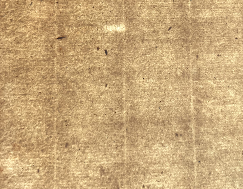
As the need for paper grew, the availability of sufficient rags and the cost to process the rags into pulp became a hindrance to the papermaking industry. Less expensive raw materials were sought, which resulted in the invention of wood pulp paper. Wood was identified as an alternative as it contained the same cellulous fibers as the flax in linen. Plus, wood was readily available and much less expensive than linen rags. A method for grinding the wood into pulp was developed in the early nineteenth century for use in making paper, which yielded an even smoother surface than wove paper.
This image of mid-19th century wood pulp paper, using backlight, shows the smooth texture, with fewer inconsistencies than earlier types of paper.
However, the process resulted in paper that was prone to tearing easily and darkening in color over time. The fragility of wood pulp paper was due in part to the fact that the cellulose fibers in wood pulp were much shorter than those in linen or cotton, so they didn’t overlap and interlock well. The other issue was that wood naturally contained lignin, which releases acids when exposed to oxygen and light, causing the paper to darken and weaken over time. While improvements to the process were introduced in the middle of the nineteenth century, allowing for longer fibers and removing some of the lignin, maps from the nineteenth century are typically more fragile and in poorer condition than their counterparts that are printed on handmade laid or wove paper.
This 1840 map by the SDUK shows the characteristic toning and brittle edges that are more commonly found with maps printed on wood pulp paper.
Mapmaking Over the Centuries
The progression of printing and papermaking from the fifteenth to nineteenth centuries are an integral aspect of mapmaking. Understanding the changes over time can help illuminate the challenges that mapmakers faced. Each method of printing and papermaking had its advantages and limitations and directly impacted how mapmakers approached their craft and the types of maps they produced. As a result, we see a wide variety in the appearance of maps over the centuries, which makes maps such a fascinating and diverse area of study.
References:
Account of the Methods and Processes adopted for the production of the maps of the Ordnance Survey of the United Kingdom, 2nd ed. (London, 1902).
Broecke, Marcel van den, “How Rare Is a Map and the Atlas it Comes From?,” The Map Collector Issue No. 36 (1986): 2-12.
Broecke, Marcel van den, “Unmasking a Forgery,” Mercator’s World Volume 3 Number 3 (1998): 48-49.
“Chromolithography,” Wikimedia Foundation, last modified 27 November 27, 2025, 12:39 (UTC), https://en.wikipedia.org/wiki/Chromolithography
Churchill, W. A., Watermarks in Paper in Holland, England, France, Etc., in the XVII and XVIII Centuries and their Interconnection (Menno Hertzberger & Co., 1965).
Laurentius, Frans and Theo Laurentius, Watermarks 1450-1850: A Concise History of Paper in Western Europe (Brill, 2023).
Hunter, Dard, Papermaking: The History and Technique of an Ancient Craft (Dover Publications, Inc., 2024).
Woodward, David, Five Centuries of Map Printing (University of Chicago Press, 1975).