Showing Featured Lots(remove filter)
Filtered by Category:United States(Show All Categories)
Catalog Archive
2139 lots
Page 1 of 43
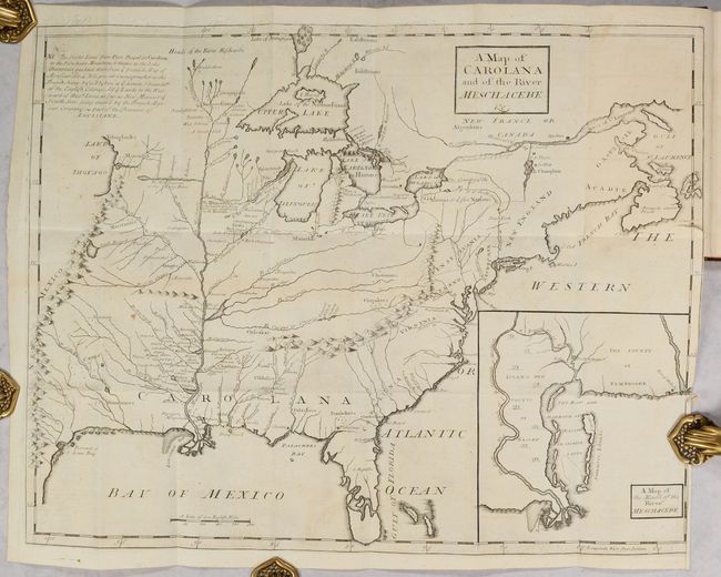
Auction 197, Lot 98
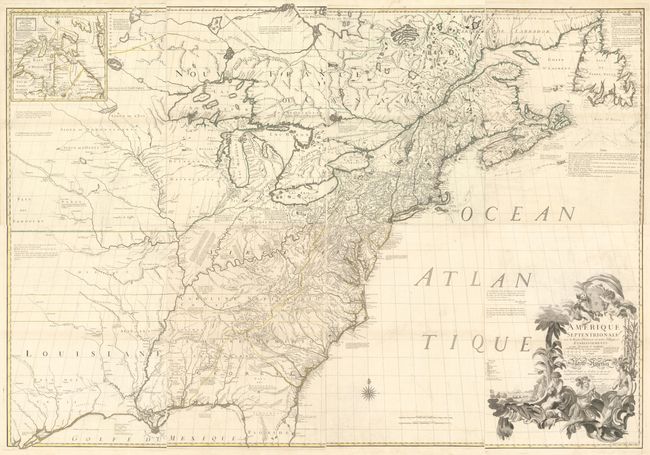
Subject: Colonial Eastern United States & Canada
Coxe, Daniel
[Map in Book] A Map of Carolana and of the River Meschacebe &c. [in] A Description of the English Province of Carolana. By the Spaniards Call'd Florida, and by the French, la Louisiane, 1741
Size: 21.5 x 16.8 inches (54.6 x 42.7 cm)
Estimate: $8,000 - $9,500
First English Depiction of the Mississippi Valley
Sold for: $7,500
Closed on 4/24/2024
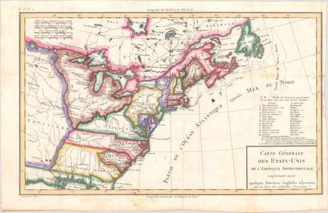
Auction 197, Lot 100
Subject: Eastern United States & Canada, Franklin
Crevecoeur, Michel Guillaume De
Carte Generale des Etats-Unis de l'Amerique Septentrionale, Renfermant Aussi Quelques Provinces Angloises Adjacentes, pour les Lettres d'un Cultivateur Ameriquain, 1787
Size: 16.9 x 10.2 inches (42.9 x 25.9 cm)
Estimate: $600 - $750
One of the Earliest Maps to Name Franklinia
Sold for: $450
Closed on 4/24/2024
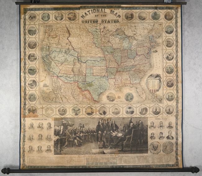
Auction 197, Lot 117
Subject: United States
Phelps & Watson
Phelps' New National Map of the United States, 1859
Size: 36.5 x 37.8 inches (92.7 x 96 cm)
Estimate: $2,200 - $2,500
Attractive Wall Map Issued at the Onset of the Civil War
Sold for: $1,400
Closed on 4/24/2024
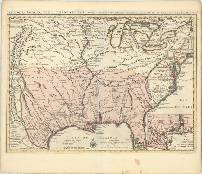
Auction 197, Lot 133
Subject: Colonial Eastern United States, Louisiana Territory
Delisle/Covens & Mortier
Carte de la Louisiane et du Cours du Mississipi Dressee sur un Grand Nombre de Memoires Entr' Autres sur ceux de Mr. le Maire, 1730
Size: 23.5 x 17.2 inches (59.7 x 43.7 cm)
Estimate: $2,200 - $2,500
Delisle's Influential Map of the Louisiana Territory
Sold for: $1,600
Closed on 4/24/2024
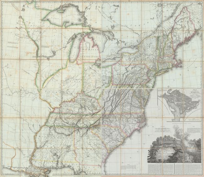
Auction 197, Lot 137
Subject: Eastern United States
Tardieu, Pierre Francois
[On 4 Sheets] United States of Nth America - Carte des Etats-Unis de l'Amerique Septentrionale Copiee et Gravee sur celle d'Arrowsmith..., 1812
Size: 27.9 x 23.9 inches (70.9 x 60.7 cm)
Estimate: $3,500 - $4,500
Rare French Edition of Arrowsmith's Influential Map of the United States
Sold for: $3,500
Closed on 4/24/2024
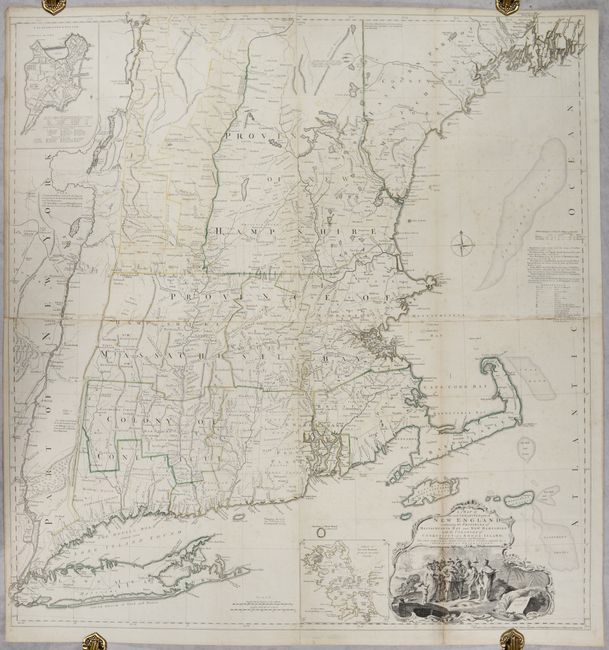
Auction 197, Lot 145
Subject: Colonial New England United States
Jefferys, Thomas
A Map of the Most Inhabited Part of New England, Containing the Provinces of Massachusets Bay and New Hampshire, with the Colonies of Conecticut and Rhode Island..., 1755
Size: 39.1 x 40.8 inches (99.3 x 103.6 cm)
Estimate: $4,750 - $6,000
Rare State of Jefferys' Influential Map of New England in Contemporary Color
Unsold
Closed on 4/24/2024

Auction 197, Lot 148
Subject: Colonial Mid-Atlantic United States
Speed/Lamb
A Map of Virginia and Maryland, 1676
Size: 19.6 x 14.9 inches (49.8 x 37.8 cm)
Estimate: $4,000 - $4,750
The First Printed Map to Draw Upon the Legendary Herrman Map of the Chesapeake Bay
Sold for: $2,600
Closed on 4/24/2024
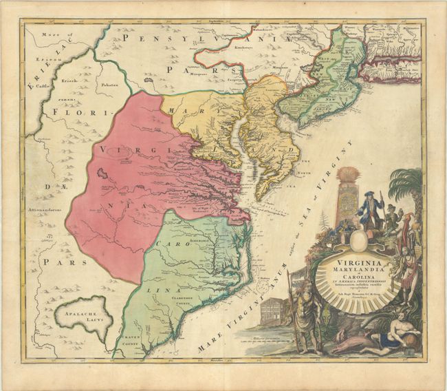
Auction 197, Lot 149
Subject: Colonial Mid-Atlantic United States
Homann, Johann Baptist
Virginia Marylandia et Carolina in America Septentrionali Britannorum Industria Excultae, 1720
Size: 22.8 x 19.3 inches (57.9 x 49 cm)
Estimate: $1,400 - $1,700
Map Created to Promote German Immigration to the New World
Sold for: $1,000
Closed on 4/24/2024
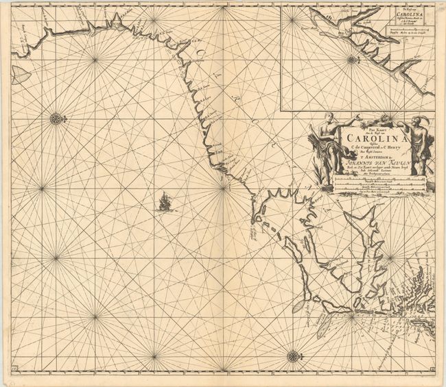
Auction 197, Lot 155
Subject: Colonial Southeastern United States
Keulen, Johannes van
Pas Kaart van de Kust van Carolina Tusschen C de Canaveral en C Henry, 1702
Size: 23 x 20.3 inches (58.4 x 51.6 cm)
Estimate: $2,400 - $3,000
Dutch Chart of the Carolinas
Unsold
Closed on 4/24/2024
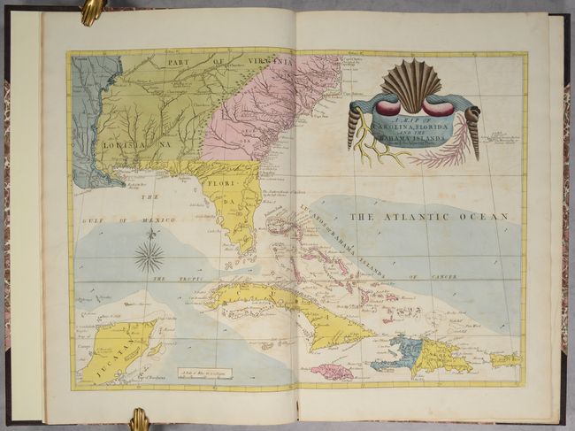
Auction 197, Lot 156
Subject: Colonial Southeastern United States & Bahamas
Catesby, Mark
[Map in Book] A Map of Carolina, Florida and the Bahama Islands with the Adjacent Parts [in] The Natural History of Carolina, Florida, and the Bahama Islands..., 1771
Size: 23.5 x 17.1 inches (59.7 x 43.4 cm)
Estimate: $9,500 - $12,000
Map and Text from Catesby's "Natural History of Carolina"
Sold for: $10,500
Closed on 4/24/2024
Auction 197, Lot 157
Subject: Southeastern United States
Bartram, William
Travels Through North & South Carolina, Georgia, East & West Florida, the Cherokee Country, the Extensive Territories of the Muscogulges, or Creek Confederacy, and the Country of the Chactaws..., 1791
Size: 5.9 x 9.8 inches (15 x 24.9 cm)
Estimate: $10,000 - $12,000
Complete First Edition of Bartram's Work on the American Southeast
Unsold
Closed on 4/24/2024
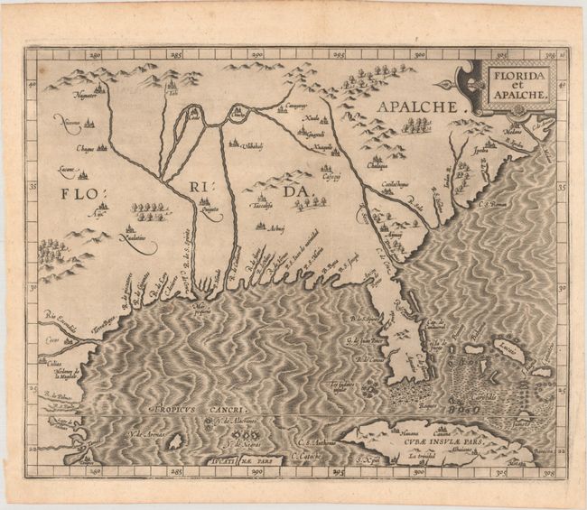
Auction 197, Lot 160
Subject: Southern United States
Wytfliet, Cornelis
Florida et Apalche, 1597
Size: 11.4 x 9.1 inches (29 x 23.1 cm)
Estimate: $3,250 - $4,000
One of the Earliest Obtainable Maps of Florida & the Southeast
Sold for: $3,250
Closed on 4/24/2024
Auction 197, Lot 162
Subject: Colonial Southern United States
[Map in Book] [New Map of Georgia] [in] Reasons for Establishing the Colony of Georgia, with Regard to the Trade of Great Britain..., 1733
Size: 7.3 x 5.3 inches (18.5 x 13.5 cm)
Estimate: $5,500 - $6,500
First Printed Map to Name Georgia
Unsold
Closed on 4/24/2024
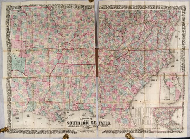
Auction 197, Lot 166
Subject: Southern United States, Civil War
Colton, Joseph Hutchins
J.H. Colton's Map of the Southern States. Maryland, Delaware, Virginia, Kentucky, Tennessee, Missouri, North Carolina, South Carolina, Georgia, Alabama, Mississippi, Arkansas, Louisiana and Texas..., 1864
Size: 52.7 x 38 inches (133.9 x 96.5 cm)
Estimate: $2,500 - $3,250
Large-Scale Map of the South Issued During the Civil War
Unsold
Closed on 4/24/2024
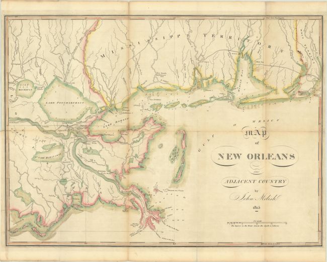
Auction 197, Lot 170
Subject: Louisiana & Mississippi
Melish, John
Map of New Orleans and Adjacent Country, 1815
Size: 21 x 15.4 inches (53.3 x 39.1 cm)
Estimate: $3,500 - $4,500
Scarce War of 1812 Map Highlighting the Gulf Theater of War
Sold for: $1,800
Closed on 4/24/2024
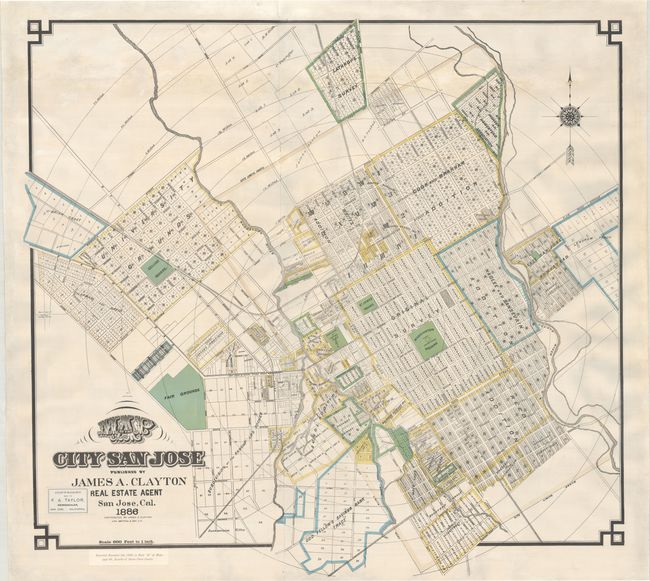
Auction 197, Lot 203
Subject: San Jose, California
Britton & Rey
Map of the City of San Jose, 1886
Size: 37.2 x 35 inches (94.5 x 88.9 cm)
Estimate: $2,000 - $2,500
An Early Large-Format Map of San Jose
Sold for: $1,500
Closed on 4/24/2024
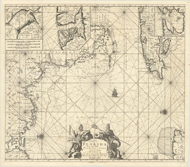
Auction 197, Lot 226
Subject: Western Florida & Cuba
Keulen, Gerard van
Pas Kaart van de Boght van Florida met de Canaal Tusschen Florida en Cuba , 1734
Size: 22.8 x 20.1 inches (57.9 x 51.1 cm)
Estimate: $2,400 - $3,000
One of the First Charts of the Florida Gulf Coast
Unsold
Closed on 4/24/2024
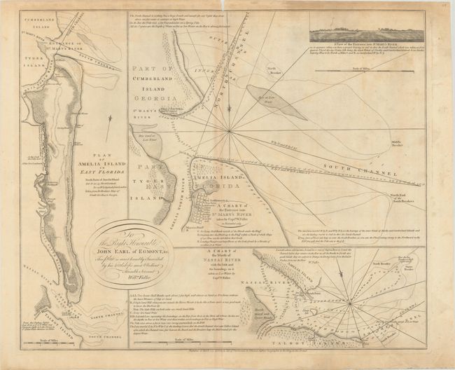
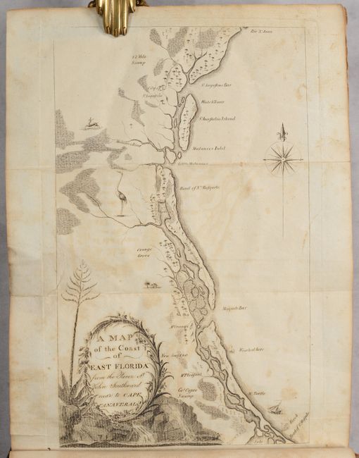
Auction 197, Lot 228
Subject: Amelia Island, Florida
Jefferys, Thomas
A Chart of the Entrance into St. Mary's River Taken by Captn. W. Fuller in November 1769 [on sheet with] Plan of Amelia Island in East Florida [and] A Chart of the Mouth of Nassau River... , 1770
Size: 24.1 x 20 inches (61.2 x 50.8 cm)
Estimate: $3,000 - $3,750
Important Charts Detailing Amelia Island and Surrounding Rivers
Unsold
Closed on 4/24/2024
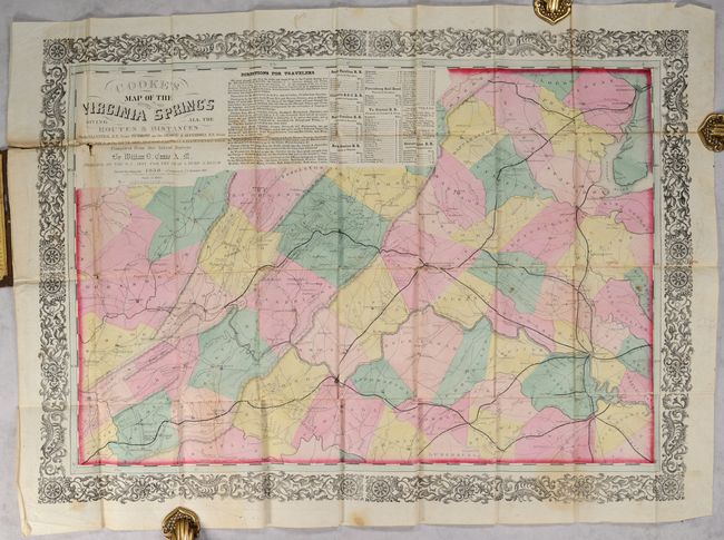
Auction 197, Lot 295
Subject: Virginia
Cooke's Map of the Routes to the Virginia Spring's Giving All the Routes & Distances on the VA Central R.R. from Richmond on the Orange & Alexandria R.R..., 1858
Size: 28.9 x 19.9 inches (73.4 x 50.5 cm)
Estimate: $3,000 - $3,750
Rare Richmond Imprint Map Promoting Virginia Mineral Springs
Sold for: $2,400
Closed on 4/24/2024
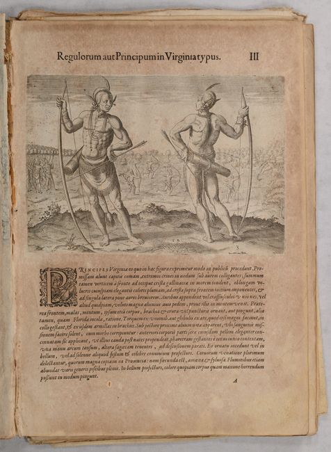
Auction 197, Lot 298
Subject: Virginia, Natives
White/De Bry
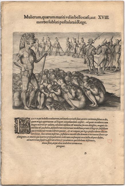
[Grands Voyages, Part I] Admiranda Narratio Fida Tamen, de Commodis et Incolarum Ritibus Virginiae, Nuper Admodum ab Anglis..., 1608
Size: 9.8 x 14 inches (24.9 x 35.6 cm)
Estimate: $4,000 - $4,750
Complete Set of De Bry's Native Virginians from Part I of Grands Voyages
Sold for: $7,000
Closed on 4/24/2024
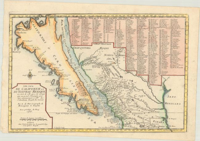
Auction 197, Lot 313
Subject: Southwestern United States & Mexico, California
Fer, Nicolas de
Cette Carte de Californie et du Nouveau Mexique, est Tiree de Celle qui a ete Envoyee par un Grand d'Espagne pour Etre Communiquee a Mrs. de l'Academie Royale des Sciences, 1705
Size: 13.4 x 8.9 inches (34 x 22.6 cm)
Estimate: $1,100 - $1,400
De Fer's Important Map of the Island of California
Sold for: $900
Closed on 4/24/2024
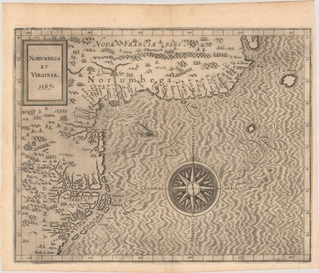
Auction 196, Lot 123
Subject: Colonial Northeastern United States & Canada
Wytfliet, Cornelis
Norumbega et Virginia, 1597
Size: 11.6 x 9.1 inches (29.5 x 23.1 cm)
Estimate: $2,750 - $3,500
Important, Early Map of the East Coast with Mythical City
Sold for: $3,750
Closed on 2/7/2024
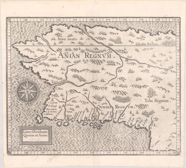
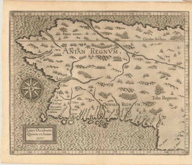
Auction 196, Lot 127
Subject: Alaska & Western Canada
Wytfliet, Cornelis
Limes Occidentis Quivira et Anian, 1607
Size: 11.6 x 9.3 inches (29.5 x 23.6 cm)
Estimate: $2,000 - $2,300
Early and Imaginary Map of Alaska and the Northwest Passage
Unsold
Closed on 2/7/2024
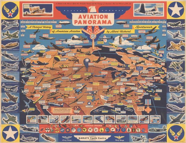
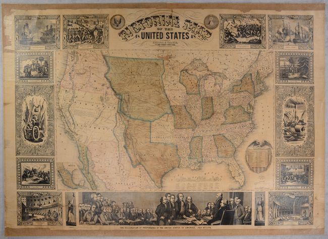
Auction 196, Lot 140
Subject: United States, Aviation
Aviation Panorama - A Pictorial History of American Aviation, 1943
Size: 22 x 16.9 inches (55.9 x 42.9 cm)
Estimate: $550 - $700
World War II-Era Map Highlighting the History of American Aviation
Sold for: $550
Closed on 2/7/2024
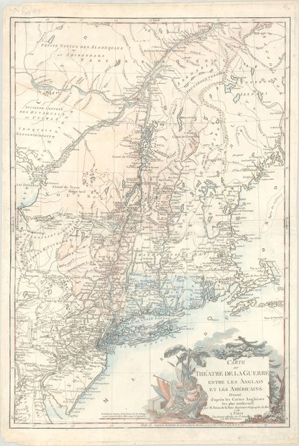
Auction 196, Lot 147
Subject: Colonial New England & Mid-Atlantic United States, Revolutionary War
Brion de la Tour, Louis
Carte du Theatre de la Guerre Entre les Anglais et les Americains: Dressee d'Apres les Cartes Anglaises les Plus Modernes, 1778
Size: 20.4 x 29.9 inches (51.8 x 75.9 cm)
Estimate: $2,750 - $3,500
Important Map Depicting Tipping Point of Revolutionary War
Sold for: $2,000
Closed on 2/7/2024
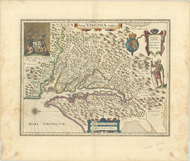
Auction 196, Lot 152
Subject: Colonial Mid-Atlantic United States
Blaeu, Willem
Nova Virginiae Tabula, 1642
Size: 18.9 x 14.8 inches (48 x 37.6 cm)
Estimate: $1,800 - $2,100
One of the Most Important 17th Century Maps of the Chesapeake Bay in Full Contemporary Color
Sold for: $8,500
Closed on 2/7/2024

Auction 196, Lot 153
Subject: Colonial Mid-Atlantic United States
Homann, Johann Baptist
Virginia Marylandia et Carolina in America Septentrionali Britannorum Industria Excultae, 1714
Size: 23 x 19.3 inches (58.4 x 49 cm)
Estimate: $1,500 - $1,800
Map Created to Promote German Immigration to the New World
Sold for: $1,100
Closed on 2/7/2024
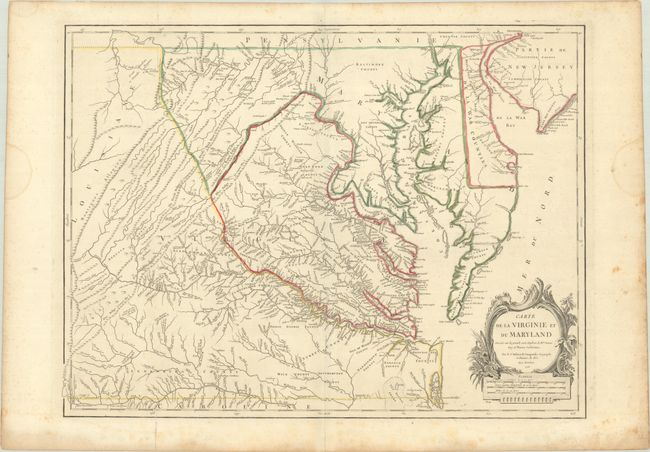
Auction 196, Lot 154
Subject: Colonial Mid-Atlantic United States
Robert de Vaugondy, Didier
Carte de la Virginie et du Maryland Dressee sur la Grande Carte Angloise de Mrs. Josue Fry et Pierre Jefferson, 1755
Size: 25.4 x 19.1 inches (64.5 x 48.5 cm)
Estimate: $2,000 - $2,300
An Essential Map of Virginia and Maryland
Sold for: $1,500
Closed on 2/7/2024
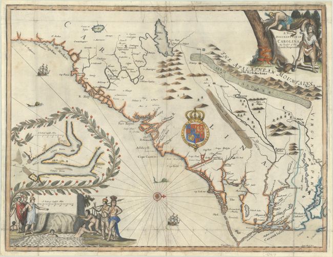
Auction 196, Lot 161
Subject: Colonial Southeastern United States
Moxon/Ogilby
A New Discription of Carolina by Order of the Lords Proprietors, 1673
Size: 21.4 x 16.5 inches (54.4 x 41.9 cm)
Estimate: $9,000 - $11,000
Ogilby's Scarce and Influential First Lords Proprietors Map
Sold for: $6,500
Closed on 2/7/2024
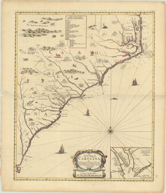
Auction 196, Lot 162
Subject: Colonial Southeastern United States
Thornton, Morden & Lea
A New Map of Carolina, 1685
Size: 17.8 x 21.5 inches (45.2 x 54.6 cm)
Estimate: $25,000 - $30,000
Rare First State of Important Early Map of the Carolinas
Sold for: $25,500
Closed on 2/7/2024
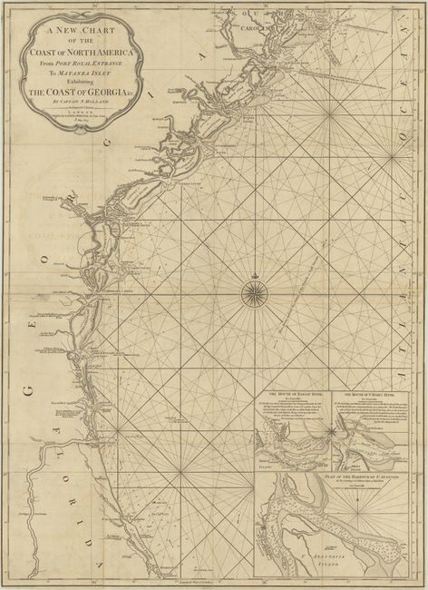
Auction 196, Lot 166
Subject: Southeastern United States
Laurie & Whittle
A New Chart of the Coast of North America from Port Royal Entrance to Matanza Inlet Exhibiting the Coast of Georgia &c., 1809
Size: 20.5 x 28.4 inches (52.1 x 72.1 cm)
Estimate: $4,000 - $4,750
Rare Chart of the Coastline of Georgia
Sold for: $9,000
Closed on 2/7/2024
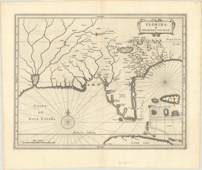
Auction 196, Lot 169
Subject: Colonial Southern United States
Gerritsz/De Laet
Florida, et Regiones Vicinae, 1640
Size: 14.1 x 11.1 inches (35.8 x 28.2 cm)
Estimate: $3,000 - $3,750
De Laet's Important Map of the South
Sold for: $2,000
Closed on 2/7/2024
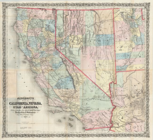
Auction 196, Lot 194
Subject: Southwestern United States
Bancroft, A.L. & Company
Bancroft's Map of California, Nevada, Utah and Arizona, 1871
Size: 33.1 x 30.3 inches (84.1 x 77 cm)
Estimate: $1,400 - $1,700
From the Greatest Map Publisher of the Pacific Coast
Sold for: $3,250
Closed on 2/7/2024
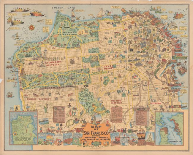
Auction 196, Lot 205
Subject: San Francisco, California
Map of San Francisco Showing Principal Streets and Places of Interest, 1927
Size: 32.3 x 25.9 inches (82 x 65.8 cm)
Estimate: $1,500 - $1,800
"One of the Most Ambitious of the Early Pictorial Maps"
Sold for: $2,400
Closed on 2/7/2024
Auction 196, Lot 226
Subject: Florida, Natives
Le Moyne/De Bry
[Grands Voyages, Vol. II] Brevis Narratio Eorum quae in Florida Americae Provicia..., 1609
Size: 9.6 x 14.3 inches (24.4 x 36.3 cm)
Estimate: $3,500 - $4,250
Complete Set of De Bry's Native Floridians from Part II
Sold for: $2,500
Closed on 2/7/2024
Auction 196, Lot 228
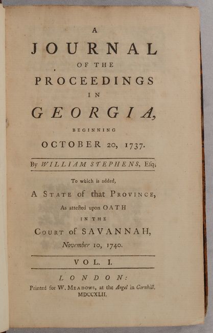
Subject: Colonial Georgia
[2 Volumes] A Journal of the Proceedings in Georgia, Beginning October 20, 1737..., 1742
Size: 5.3 x 8.1 inches (13.5 x 20.6 cm)
Estimate: $3,000 - $4,000
Important Overview of the Colony of Georgia with Only 70 Copies Printed
Sold for: $6,000
Closed on 2/7/2024
Auction 196, Lot 261
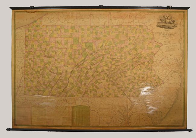
Subject: Pennsylvania
Barnes, R. L.
Map of Pennsylvania, Constructed from the County Surveys Authorized by the State; and Other Original Documents, Revised and Improved..., 1850
Size: 74.6 x 50.4 inches (189.5 x 128 cm)
Estimate: $2,200 - $2,500
Melish's Epic Map of the State - Updated by William Morris
Sold for: $1,600
Closed on 2/7/2024
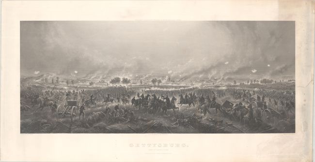
Auction 196, Lot 265
Subject: Gettysburg, Pennsylvania, Civil War
Bachelder, John B.
Gettysburg. Repulse of Longstreet's Assault, 1876
Size: 35 x 14.4 inches (88.9 x 36.6 cm)
Estimate: $1,400 - $1,700
Stunning View of Pickett's Charge
Sold for: $1,600
Closed on 2/7/2024
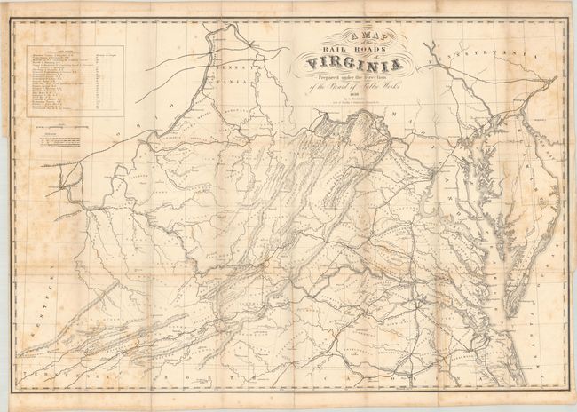
Auction 196, Lot 274
Subject: Virginia, Railroads
Bucholtz, Ludwig von
A Map of the Rail Roads of Virginia Prepared Under the Direction of the Board of Public Works, 1858
Size: 34.6 x 23.3 inches (87.9 x 59.2 cm)
Estimate: $5,000 - $7,000
Rare Railroad Map of Virginia - Bucholtz’s Earliest Work
Sold for: $6,000
Closed on 2/7/2024
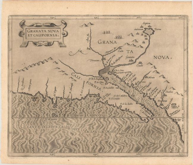
Auction 196, Lot 283
Subject: Southwestern United States & Mexico
Wytfliet, Cornelis
Granata Nova et California, 1597
Size: 11.4 x 9.1 inches (29 x 23.1 cm)
Estimate: $2,750 - $3,500
First Printed Map to Focus on California and the Southwest
Sold for: $2,000
Closed on 2/7/2024
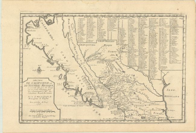
Auction 196, Lot 285
Subject: Southwestern United States & Mexico, California
Fer, Nicolas de
Cette Carte de Californie et du Nouveau Mexique, est Tiree de Celle qui a ete Envoyee par un Grand d'Espagne pour etre Communiquee a Mrs de l'Academie Royale des Sciences, 1705
Size: 13.5 x 8.9 inches (34.3 x 22.6 cm)
Estimate: $1,100 - $1,400
De Fer's Important Map of the Island of California
Sold for: $800
Closed on 2/7/2024
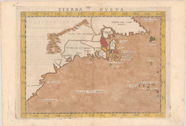
Auction 195, Lot 134
Subject: Eastern United States & Canada
Ruscelli, Girolamo
Tierra Nueva, 1574
Size: 9.7 x 7.1 inches (24.6 x 18 cm)
Estimate: $1,200 - $1,500
Ruscelli's Map of the East Coast
Sold for: $850
Closed on 11/15/2023
Auction 195, Lot 137
Subject: Colonial Eastern United States & Canada
Mitchell/Le Rouge
[On 8 Sheets] Amerique Septentrionale avec les Routes, Distances en Miles, Villages et Etablissements Francois et Anglois..., 1756
Size: 19 x 26.8 inches (48.3 x 68.1 cm)
Estimate: $10,000 - $13,000
French Edition of Mitchell's Monumental Map
Sold for: $7,500
Closed on 11/15/2023
Auction 195, Lot 154
Subject: Alaska & Western Canada
Wytfliet, Cornelis
Limes Occidentis Quivira et Anian, 1597
Size: 11.5 x 9.3 inches (29.2 x 23.6 cm)
Estimate: $1,900 - $2,200
Early and Imaginary Map of Alaska and the Northwest Passage
Sold for: $1,700
Closed on 11/15/2023
Auction 195, Lot 158
Subject: United States
Ensign, Thayer & Co.
Pictorial Map of the United States, 1848
Size: 39.8 x 29 inches (101.1 x 73.7 cm)
Estimate: $1,500 - $1,800
Spectacular Wall Map Published at the Conclusion of the Mexican-American War
Sold for: $1,100
Closed on 11/15/2023
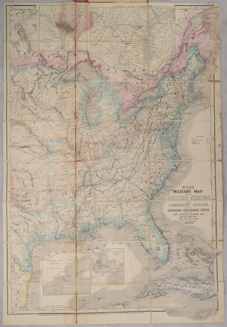
Auction 195, Lot 185
Subject: Eastern United States
Wyld, James
Wyld's Military Map of the United States, the Northern States, and the Southern Confederate States: with the Forts, Harbours, Arsenals, and Military Positions, 1861
Size: 23.8 x 35.1 inches (60.5 x 89.2 cm)
Estimate: $1,800 - $2,100
Important Civil War Map
Sold for: $1,100
Closed on 11/15/2023
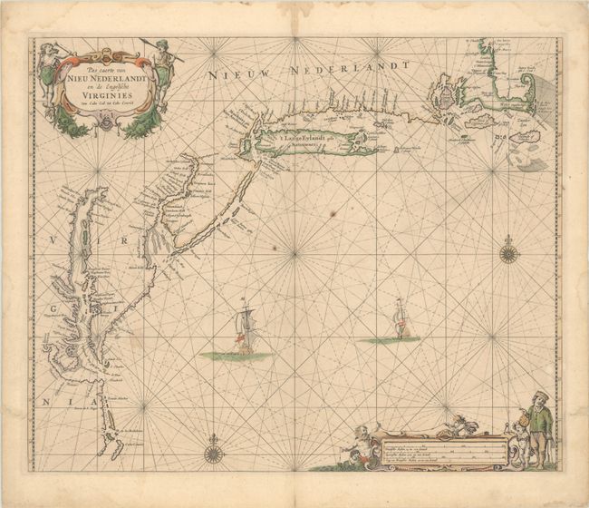
Auction 195, Lot 187
Subject: Colonial New England & Mid-Atlantic United States
Goos, Pieter
Pas Caerte van Nieu Nederlandt en de Engelsche Virginies van Cabo Cod tot Cabo Canrick, 1666
Size: 20.8 x 16.9 inches (52.8 x 42.9 cm)
Estimate: $5,500 - $6,500
Goos' Gorgeous Chart of the Mid-Atlantic & New England
Sold for: $4,000
Closed on 11/15/2023
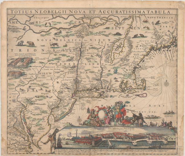
Auction 195, Lot 188
Subject: Colonial New England & Mid-Atlantic United States
Allard, Hugo
Totius Neobelgii Nova et Accuratissima Tabula, 1674
Size: 21.3 x 18.4 inches (54.1 x 46.7 cm)
Estimate: $11,000 - $14,000
Exceedingly Rare 2nd State Known in only 2 Other Examples
Sold for: $6,000
Closed on 11/15/2023
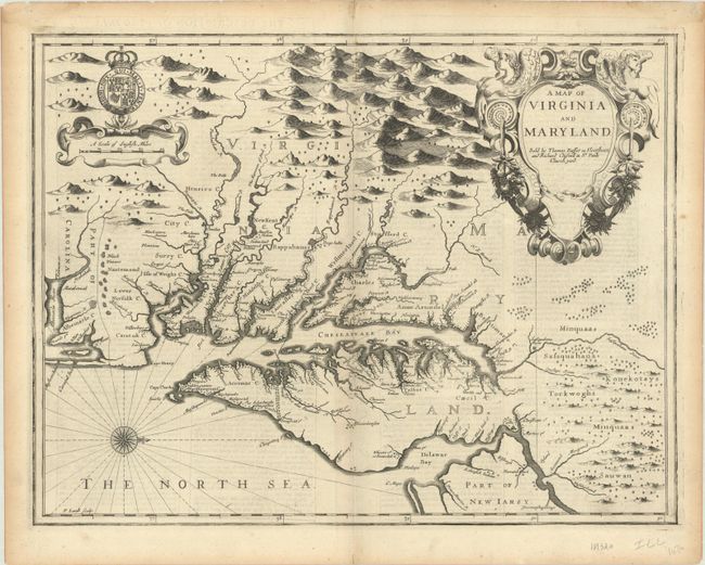
Auction 195, Lot 193
Subject: Colonial Mid-Atlantic United States
Speed/Lamb
A Map of Virginia and Maryland, 1676
Size: 19.6 x 14.9 inches (49.8 x 37.8 cm)
Estimate: $4,000 - $4,750
The First Printed Map to Draw Upon the Legendary Herrman Map of the Chesapeake Bay
Unsold
Closed on 11/15/2023
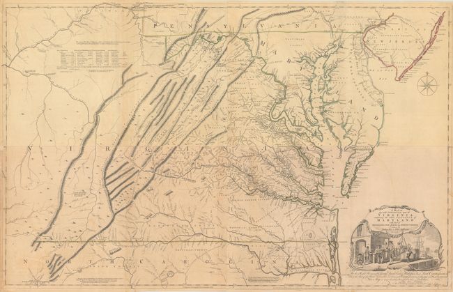
Auction 195, Lot 195
Subject: Colonial Mid-Atlantic United States, Virginia
Fry, Joshua & Jefferson, Peter
[On 4 Sheets] A Map of the Most Inhabited Part of Virginia Containing the Whole Province of Maryland with Part of Pensilvania, New Jersey and North Carolina, 1775
Size: 48.4 x 15.7 inches (122.9 x 39.9 cm)
Estimate: $14,000 - $17,000
1775 Edition of the Landmark Fry-Jefferson Map of Virginia and Maryland
Sold for: $13,500
Closed on 11/15/2023
2139 lots
Page 1 of 43