Subject: Virginia, Railroads
Period: 1858 (dated)
Publication:
Color: Black & White
Size:
34.6 x 23.3 inches
87.9 x 59.2 cm
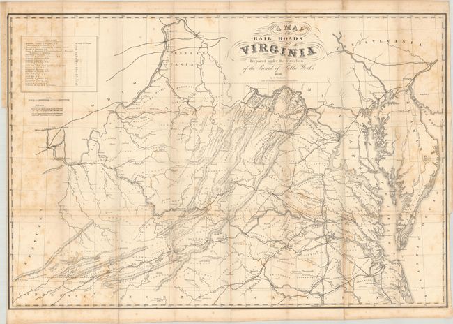
This rare railroad map graphically represents Ludwig von Bucholtz’s earliest work under the Virginia Board of Public Works. Bucholtz, a German emigrant, was hired by Claudius Crozet, Chief Engineer of the Public Works, to replace Anthony Kanalassi who had died in 1852. While Bucholtz is more famously known for updating the mammoth Boye map of 1826 in 1859, his first task was updating Crozet’s 1848 map entitled A Map of the Internal Improvements in Virginia.
Issued just a few years prior to the outbreak of the Civil War, the map presents the sizeable transportation network in the state with a legend identifying railroads, railroads under construction, proposed railroads, canals, and “improved rivers.” While the majority of the completed lines fall in the eastern half of the state, several railroads push west including the Baltimore & Ohio (Wheeling), the Virginia Central Railroad (Covington), and the Virginia & Tennessee Railroad (beyond Bristol). A table at top left summarizes 23 different railroads which total over 2,200 miles of track (completed and under construction), presenting the state as an attractive option for commerce between the Ohio River (and therefore Mississippi River) and the Atlantic Ocean. In addition to transportation, the map shows county boundaries, cities and town, rivers and topography. Lithography by Ritchie & Dunnavant in Richmond, Virginia. Richmond imprints are generally scarce leading up to and in the early years of the Civil War due to the evacuation and burning of the city, the capital of the Confederacy, by Union forces in 1865.
This map is not mentioned by name in any publication within our reference library, but is alluded to in Stephenson & McKee. We found only one past sales record for this map (Old World Auctions in 2006) and only three institutional examples on OCLC (Library of Virginia, University of Virginia, and Duke University). A rare railroad map of pre-Civil War Virginia.
References:
Condition: B
Issued folding on heavy paper with scattered foxing and some minor offsetting. A 4.5" binding tear at left and a 6" fold separation at top have both been closed on verso with archival tape. There are binding trims at left and lower right.