Subject: Colonial Southeastern United States
Period: 1685 (circa)
Publication:
Color: Hand Color
Size:
17.8 x 21.5 inches
45.2 x 54.6 cm
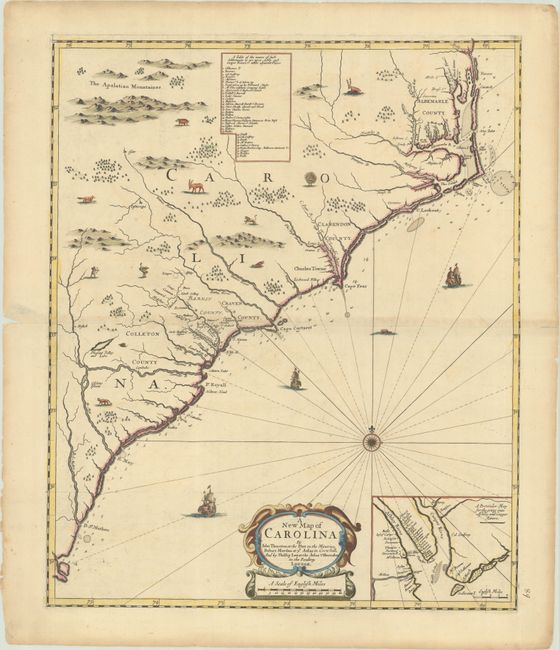
This is the rare first state of John Thornton, Robert Morden and Philip Lea's map of the coast of Carolina, extending west to the Appalachian mountains. This map was largely based on Joel Gascoyne's A New Map of the Country of Carolina (1682), including copying the content and shape of the table and the inset map, however orienting the map to the north instead of to the west. The table lists the settlements and landowners along the Ashley and Cooper Rivers, and the inset map depicts the mouths of these rivers and the area around Charleston. This edition also continues Gascoyne's outdated depiction of the R. S. Matheo from Spanish sources and the R. May from French sources, both of which referred to St. Johns River. River May most likely represents the Savannah River, although it is shown too far south. The decorative elements are also quite similar to Gascoyne's map, however the Thornton/Morden/Lea edition shows a bit more variety in the animals that fill the blank spaces, including an ostrich and a turtle, and adds a Native American with a bow and arrow, as well as several ships and a sea monster in the Atlantic. Interestingly, this map borrows some elements from the first state of Gascoyne's map, such as the Pleasant Valley and Lake, and some from the second state, such as the inset map, which Gascoyne revised in the second state.
Thornton, Morden and Lea also used other sources, as evidenced by the depiction of the Outer Banks and the depth soundings along the coastline, which are similar to a manuscript map by James Lancaster in 1679 that was found in the Blathwayt atlas in the John Carter Brown Library. While Gascoyne's map was considered the most accurate map of its time when it was published in 1682, the Thornton/Morden/Lea map effectively surpassed Gascoyne's map in accuracy due to the updates to the Outer Banks, and remained the most influential map of the region for several decades.
An interesting aspect of this map is that although it was issued separately, it was also intended as part of a five-sheet wall map by the same authors, titled A New Map of the English Empire in the Continent of America. A faintly visible engraved line that stretches horizontally above the title cartouche and inset map marks the portion of the map that would be trimmed off to fit this sheet into the wall map. Thornton, Morden and Lea devised a clever plan to create map of the colonies stretching from New England to the Southeast that could either be sold as a multi-sheet wall map, or as separate sheets of individual portions of the colonies, such that each sheet could either stand on its own or be trimmed to fit into the wall map.
This example is the first of three known states, and was published separately by Thornton, Morden and Lea around 1685. Around 1690, Lea bought the plate and reissued it with the imprint altered to omit the names of Thornton and Lea. Lea also used the inset map alone in his Hydrographia Universalis around 1700. After Lea's death in 1705, his widow continued his business, and sold this plate to George Willdey sometime between 1725-35. Willdey reissued the plate for a final time with his own imprint. All editions of this map are extremely rare.
References: Burden #617; Cumming #104; Stevens & Tree (MCC-39) #10a.
Condition: B+
A sharp impression with full contemporary color, minor offsetting, light toning along the centerfold, and a few minor spots. There is an old manuscript page number at bottom right, short centerfold separations at right and left, and light toning and soiling along the edges of the sheet.