Subject: United States, Aviation
Period: 1943 (circa)
Publication:
Color: Printed Color
Size:
22 x 16.9 inches
55.9 x 42.9 cm
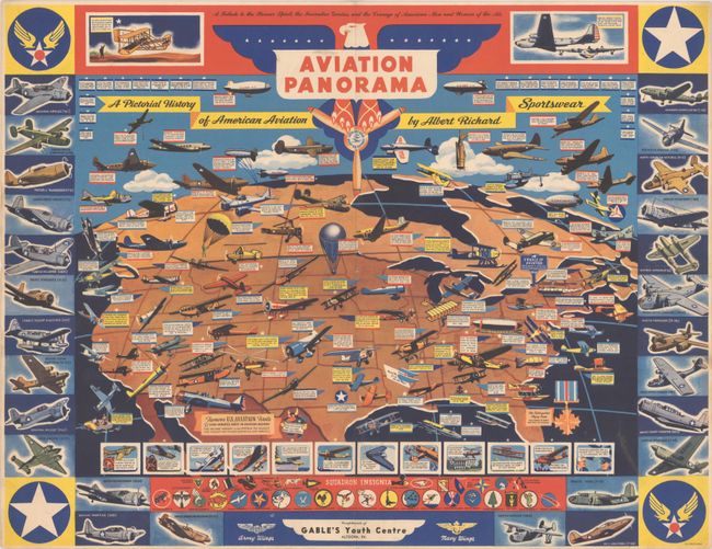
This World War II-era pictorial map showcasing American aviation was created by F.E. Cheeseman for Milwaukee-based clothing manufacturer Albert Richard. The landscape of the United States is filled with illustrations of various aircraft, each one marking a milestone in the history of aviation. Among the important moments pictured are Octave Chanute's glider flights over Indiana sand dunes (1896), the Wright brothers first flight (1903), the first transcontinental air mail flight (1921), Amelia Earhart's solo flight across the Pacific (1935), Howard Hughes' trip around the world in a "Flying Laboratory" (1938), and the first successful helicopter flight (1941). The map is further surrounded by several types modern warplanes, squadron insignia, and vignettes of notable achievements in aviation history, including contemporary acts of heroics, Franklin D. Roosevelt flying to meet Winston Churchill in Casablanca (the first flight by a U.S. president), and "the Flying Wing," a futuristic prototype aircraft. A "good gremlin" at bottom encourages folks to buy U.S. war bonds and stamps. The verso advertises Albert Richard's various jackets and coats, with a patriotic reminder that "Uncle Sam's fighting men" are wearing their products all over the world.
References: Rumsey #9019.
Condition: B+
A colorful example, issued folding, with a short fold separation at left. Folded horizontally across the center of the map by a previous owner.