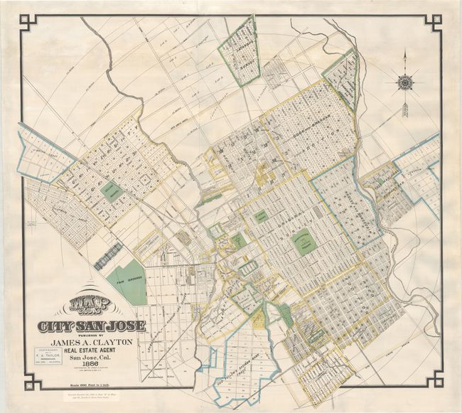
Subject: San Jose, California
Period: 1886 (dated)
Publication:
Color: Printed Color
Size:
37.2 x 35 inches
94.5 x 88.9 cm
This separately-issued, large-format map of San Jose was published by James Clayton and lithographed by Britten & Rey in San Francisco. It is an early depiction of the growing city and is predated only by an early survey by Thomas White in 1850 and smaller city map by George Hare in 1872. The “original survey” is identified at center with concentric circles radiating out from downtown in quarter mile increments beyond the city limits. Several additions and other tracts surround the original survey including the Cook and Branham Addition, Naglee and Sansevian Addition, Reed Addition, Goodyear Tract, Lick Tract, and many more. To the northwest is a large University Grounds. Locates Washington Square, St. James Square, Convent of Notre Dame, Fair Grounds, some individual property owners (including Clayton himself), and more. Features a seller’s label for F.A. Taylor, Newsdealer, at lower left. Issued on two joined sheets.
James Clayton was born in England in 1831 and moved to the United States as a boy. After spending a short time as a gold prospector in both California and Australia, he settled in San Jose in the 1860s. He established his real estate office shortly thereafter and became a leading real estate figure in the burgeoning city.
San Jose traces its origin to November 29, 1777, with the establishment of the Pueblo de San Jose de Guadalupe. The pueblo was relocated to what is now the modern downtown area in 1797. Following the United States’ annexation of California in 1848, San Jose was incorporated as the state’s second city (following Sacramento) on March 27, 1850 and served as its first capital. The city was still relatively small when Clayton began his real estate venture. In 1870, there with only 9,000 inhabitants, but the city would quadruple in size over the next 50 years with nearly 40,000 residents by 1920. We found only 2 institutional examples of this 1886 edition on OCLC and 3 later editions of the map.
References:
Condition: B+
On a bright sheet that has been professionally backed with tissue to reinforce and repair numerous small tears and chips primarily in the upper portion of the image with a minute amount of image replaced in facsimile. Numerous edge chips in the margins have been professionally replaced.