Subject: Amelia Island, Florida
Period: 1770 (dated)
Publication:
Color: Black & White
Size:
24.1 x 20 inches
61.2 x 50.8 cm
Thomas Jefferys was one of the most important English map publishers of the 18th century. His work included prints and maps of locations around the world, but his most notable maps are of North America and the West Indies. He began his career in the map trade in the early 1730s, working as an engraver for a variety of London publishers, and eventually setting up his own shop. In 1746, he was appointed Geographer to the Prince of Wales, and in 1760 he became Geographer to the King. These titles granted access to manuscripts and cartographic information held by the government. In the early 1760s he embarked on an ambitious project to produce a series of English county maps based on new surveys, but ran out of money and filed for bankruptcy in 1766. He then partnered with London publisher Robert Sayer, who reissued many of Jefferys plates and continued to issue new editions after Jefferys' death in 1771. Jefferys' American Atlas and the accompanying West-India Atlas, published post posthumously, are considered his most important cartographic works.
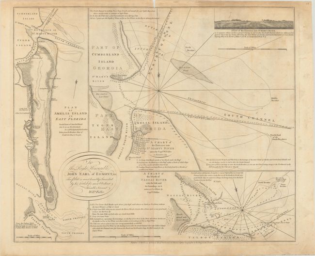
This interesting sheet has three charts of Amelia Island and the surrounding rivers based on the surveys of Captain William Fuller and John William Gerard de Brahm. After Spain ceded Florida at the end of the Seven Years' War in 1763, the British were keen to have a better understanding of their new territory and routes of navigation that could assist in commerce. At left is a plan of Amelia Island based on De Brahm's map of South Carolina and Georgia. Amelia Island is strategically located on the boundary between Florida and Georgia, and the natural deep harbor on the north end of Amelia Island was an important anchorage for all kinds of sailing vessels including smugglers, pirates, and slave ships. The largest chart details the harbor at the north end of Amelia Island with Cumberland Island and Tiger Island, showing anchorages, soundings and hazards. A "new settlement" is laid out at the northern end of Amelia Island with a grid-style street plan. The ruins of Fort William are noted at the tip of Cumberland Island. This fort was built by the British Gen. James Oglethorpe, founder of the colony of Georgia, who successfully repelled Spanish troops from Georgia in 1742. A small prospective view of the entrance to St. Mary River is included. The chart at bottom right focuses on the entrance of Nassau and St. Johns Rivers at the southern end of Amelia Island. The charts include numerous soundings and navigational notes and are dedicated to John Earl of Egmont by Captain William Fuller.
References:
Condition: B
A crisp impression on a sheet with the watermark of a Strasbourg lily with the initials "GB." There is minor offsetting, a small chip at top center with minor loss of the neatline, and the sheet has light, uneven toning and staining. There are archival repairs to a 2" tear in the view at top right, and to an edge tear at bottom center that just crosses the neatline.