Subject: Colonial Mid-Atlantic United States
Period: 1642 (circa)
Publication:
Color: Hand Color
Size:
18.9 x 14.8 inches
48 x 37.6 cm
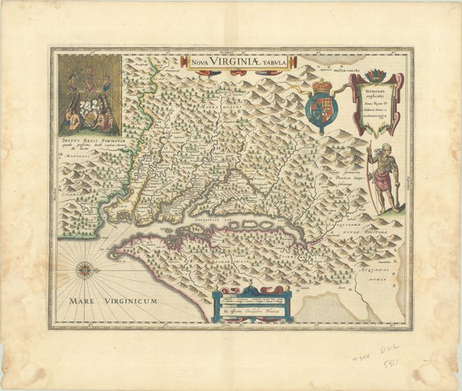
This map was derived from Capt. John Smith's map of 1612, which was the first to depict the Chesapeake Bay and its tributaries with any accuracy. The early settlement of Jamestown is noted as Iamestowne, and there are a number of other place names, both English and Native American. In the upper left corner is an engraving of the great Indian chief, Powhatan, seated on his throne and surrounded by his subjects. A Susquehanna chief is depicted on the right under the British coat-of-arms and a key cartouche. The plate was engraved by Dirck Grijp and was originally published by Jodocus Hondius Jr. in 1618. It was purchased by Willem Blaeu shortly after Hondius' death (1629) and Blaeu's imprint replaced that of Hondius. Dutch text on verso, published between 1642-64.
References: Burden #193; Portinaro & Knirsch KXXIV; Tooley (Amer) p. 161-62; Van der Krogt (Vol. II) #9410:2.2; Wooldridge #30.
Condition: B+
A crisp impression in full contemporary color on a bright sheet with three abrasions in the distance scale cartouche where the map was folded prior to the blue ink drying. There are damp stains along the sides of the sheet, entering the image about 1" in the bottom corners, and causing a few small chips along the edges of the sheet. Small remnants of hinge tape on verso.