Subject: San Francisco, California
Period: 1927 (dated)
Publication:
Color: Printed Color
Size:
32.3 x 25.9 inches
82 x 65.8 cm
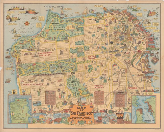
This wonderful pictorial map was drawn by Harrison Godwin and printed by Schmidt Lithography in San Francisco. It extends from Embarcadero west to the Presidio and south to Sunset, The Mission, and Potrero with insets of the peninsula at lower right and left. The map is packed full with illustrations of important sites, buildings, parks, and scores of cartoonish characters throughout including a busy Fisherman’s Wharf, a long line at the Lincoln Park golf course, a beehive of activity in Golden Gate Park, and twins viewing downtown with binoculars on “Twin Peeks.” Vignettes along the bottom of the map depict historical events including the discovery of San Francisco Bay by Portola (1769), the city’s first fire (1849), and the infamous earthquake and subsequent fire (1906). Stephen Hornsby describes the map as “one of the most ambitious of the early pictorial maps. Godwin’s affectionate depiction of the city is a riot of cartoon characters, buildings, trains and watercraft.”
References: Hornsby (Picturing America) p. 141 (Plate 63).
Condition: B
A colorful example with a 1.5" edge tear and 1.5" separation at left that have both been closed on verso with archival tape. The map has been folded by a previous owner with a couple of splits at the fold junctions. There are a few edge chips and pinholes in the corners, all outside of the map image.