Subject: United States
Period: 1848 (dated)
Publication:
Color: Hand Color
Size:
39.8 x 29 inches
101.1 x 73.7 cm
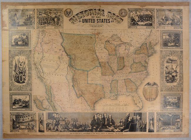
A spectacular wall map published shortly after the conclusion of the Mexican-American War, which resulted in the addition of over 500,000 square miles to the United States. Texas is depicted in its large stovepipe configuration extending north into today's Colorado, while a huge Nebraska Territory occupies the region from the Missouri River west to the Rocky Mountains. Oregon Territory occupies the entire Northwest, and an oversized Upper or New California extends from the Pacific Ocean to the Great Basin. New Mexico is sandwiched between Texas and Upper California. The map is filled with details including place names and railroads in the East, while rivers, mountains, and Indian Tribes are located in the West. A notation in the Great Basin states "contents almost unknown, but believed to be filled with rivers and lakes which have no communication with the sea, deserts and oases which have never been explored, and savage tribes, which no traveler has seen or described." In addition to the main map, there is an inset map of Mexico and state population table encompassed by the U.S. Seal. Surrounding the map is a series of 15 vignettes including the signing of the Declaration of Independence, the Landing of Columbus, and the Battle of Bunker Hill. Engraved by J.M. Atwood in New York. Rollers not present.
References:
Condition: B
The map has been backed with heavy linen to reinforce and repair a number of small cracks and tears as well as a 14" edge tear in the lower left vignettes. There are two small areas of loss in the image (above Minnesota and in upper Indian Territory) that have been repaired with image replaced in facsimile, light oxidation of the green pigment in the map, and a number of edge chips mostly at left. Margins were trimmed at top and bottom (having been removed from rollers) and replaced with brown paper.