Subject: Eastern United States & Canada, Franklin
Period: 1787 (circa)
Publication: Lettres d'un Cultivateur Americain…
Color: Hand Color
Size:
16.9 x 10.2 inches
42.9 x 25.9 cm
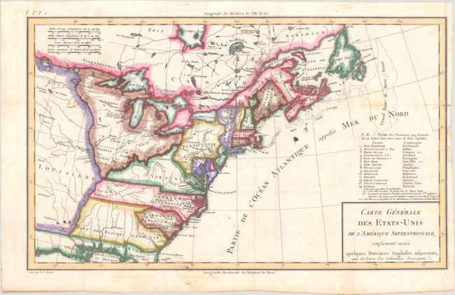
An uncommon map of the early United States and one of the first printed maps to name Frankland. Also known as Franklinia, it is shown here just west of the border of North Carolina, named Pays de Frankland. In 1785 settlers in western North Carolina and what would become eastern Tennessee organized a state government to be named in honor of Benjamin Franklin. Congress turned down their appeal, but the state maintained a legislature and governor until 1788. This ephemeral state appears on only a small number of maps. The 14th state of Vermont is named and noted in the key at right, with a notation in French that it was "not yet accepted in the confederation." Virginia is shown in a strange configuration, and there is a square-shaped region denoted as Pays de Kentukey. Engraved by Pierre Francois Tardieu.
Crevecoeur was a French-born surveyor who settled in New York, where he produced Lettres d'un Cultivateur Americain..., a classic collection of twelve essays that reflected on the nature of American life, particularly its customs and manners. His description of bountiful American lands spurred many French people to immigrate to America. Howes says that Crevecoeur's work is a: "Description of American life of great influence in attracting European immigration in the post-revolutionary period. As literature unexcelled by any American work of the eighteenth century."
References: Baynton-Williams (TMC-72) #1; Dotson & Baker (OWA) #2; Mapforum 1, Early Maps of the US #69; McCorkle #787.8.
Condition: B+
A nice impression issued folding on watermarked paper with minor foxing, errant spots of colorist's ink, and two light dampstains that just enter neatline at right. A 0.75" edge tear at right has been closed on verso with archival tape.