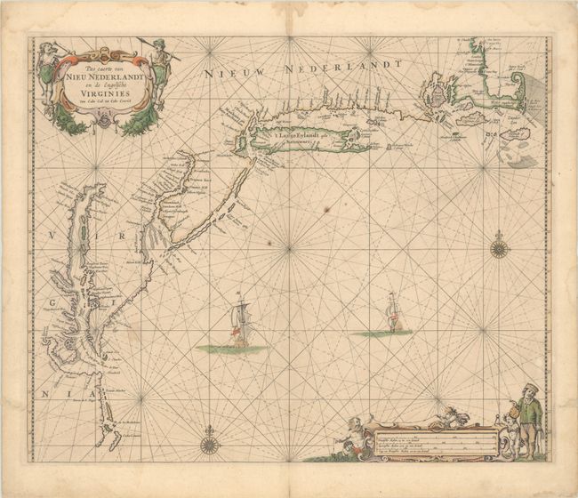
Subject: Colonial New England & Mid-Atlantic United States
Period: 1666 (circa)
Publication: De Zee Atlas ofte Water-Weereld
Color: Hand Color
Size:
20.8 x 16.9 inches
52.8 x 42.9 cm
This attractive chart of the Atlantic coast extends from the Outer Banks of North Carolina to Boston Harbor and Cape Cod. It is nearly identical to a chart issued 5 years earlier by Joannes van Loon, which itself resembles a chart by Hendrick Doncker published in 1660. The chart presents good detail of the coastlines in the Chesapeake and Delaware bays, along with improvements to the New Jersey coastline including its outer sandbanks and the correct positioning of Cape Cod. Many important place names are located including James Towne, Manhates ofte Nieu Amsterdam, Staten Eylandt and Patuxet of New Pleymont. Rood Eylant is prominently depicted in Narragansett Bay. Burden notes that while the English controlled the region at the time of publication, the chart continues to use Dutch names (likely a byproduct of Goos copying van Loon's earlier work). The chart is finely embellished with compass roses, sailing ships, and two allegorical cartouches.
References: Burden #387; Mickwitz & Miekkavaara #246-20; Phillips (A) #473-33.
Condition: B+
Full contemporary color on a double-thick sheet with light soiling, a couple of paper flaws near the center of the image, and a printer's crease to the left of the centerfold. There are light dampstains confined to the blank margins and two worm tracks in the blank margins that have been archivally infilled.