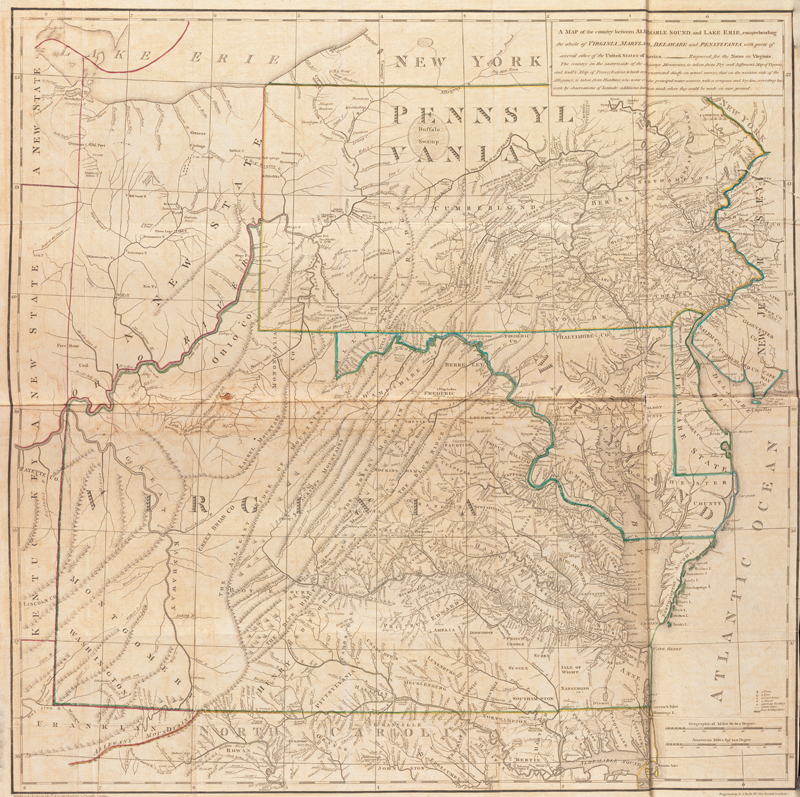
A Map of the Country Between Albemarle Sound, and Lake Erie, by Thomas Jefferson, 1787. (Image courtesy of Yale University Library, LC Maps of North America, 1750-1789, 762.)
Jefferson and Maps
by Eliane Dotson
[This article is based on a talk I presented at Monticello on behalf of the Thomas Jefferson Foundation on February 27, 2024.]
Although Thomas Jefferson is best known as a statesman, diplomat and Founding Father, one should not overlook his roles in surveying and cartography. His interest in surveying began as a boy, largely influenced by his father, Peter Jefferson, a surveyor himself. Peter Jefferson, of course, is well known for the landmark map he created with Joshua Fry, A Map of the Most Inhabited Part of Virginia…, which was first published circa 1753. Although Thomas was only 14 at the time of his father’s death in 1757, he had already learned surveying skills from his father. While there is no record of any formal education Thomas had in surveying or mapmaking, there were several milestones during his early career that enhanced his understanding of these skills.
Thomas Jefferson inherited both land and surveying tools from his father. Surveying was an important skill for landowners as they needed to mark their boundaries with neighbors, as well as to understand the topography for cultivating and building upon their land. Jefferson undertook surveys of his land and created plats for numerous projects, including his plan for Monticello.
Prior to constructing Monticello, Jefferson attended the College of William & Mary, where he studied philosophy, mathematics, physics, ethics, and other subjects befitting of the gentry. After graduating in 1762, he studied law under George Wythe and was admitted to the Virginia bar in 1767. As a lawyer, Jefferson oversaw numerous land claim disputes, requiring his knowledge of surveying and mapmaking.
He was appointed Surveyor of Albemarle County in 1773, following in his father’s footsteps, however Thomas didn’t file any surveys during his short tenure in that role. The role was more a recognition of his status than an occupation, and he enlisted his deputies to fulfill his duties in that role before resigning six months later. He did actually survey Albemarle County in 1777 when the county was divided to create Fluvanna, although his survey was intended for personal use, and was not part of the official documentation used at the time.
Over the years, Thomas amassed a great deal of knowledge of the state of Virginia through his various roles. He also formed allies and gained respect among his colleagues, and was elected as the second Governor of Virginia in 1779. While Governor, he received a request from François Barbé-Marbois to provide pertinent information on his state. Marbois was Secretary to the French legation at Philadelphia, where the Second Continental Congress was being held, and had made the same request to the Governors of each of the original 13 colonies. This request led to Jefferson publishing his only full-length book and his only map.
Jefferson submitted his responses to Marbois the following year in December 1781. He wrote twenty-three chapters, called “queries,” on various topics, such as the boundaries of Virginia, the climate, geographical features, civil law, wildlife, vegetation, and Native Americans. Of the twenty-three topics, fifteen were of geographical significance. Even well after he sent his response to Marbois, Jefferson continued to revise and expand the information he had compiled on Virginia. Colleagues requested copies of his “Notes” and he believed it would be useful to share, so he decided to print copies for private distribution in 1785. At the time he was in Paris as US Minister to France, so they were printed there and he titled the volume Notes on the State of Virginia. Jefferson did not include his name on the title page as he was uncertain about how the book would be received. He sent copies to his close colleagues, including James Madison, James Monroe, and John Adams, seeking their feedback. In a letter to James Madison on May 11, 1785 he explained:
“I had 200 copies printed, but do not put them out of my own hands, except two or three copies here, & two which I shall send to America, to yourself & Colo. Monroe […] I beg you to peruse it carefully because I ask your advice on it & ask nobody’s else. I wish to put it into the hands of the young men at the college, as well on account of the political as physical parts. But there are sentiments on some subjects which I apprehend might be displeasing to the country perhaps to the assembly or to some who lead it.”
Jefferson received responses indicating that, although some may take offense, he should move forward with publication of the book. James Madison wrote, “We think both the facts and remarks which you have assembled too valuable not to be made known.” John Adams concurred: “I think it will do its Author and his Country great Honour.”
Title page to the first edition, intended for private distribution. (Image courtesy of Christie's.)
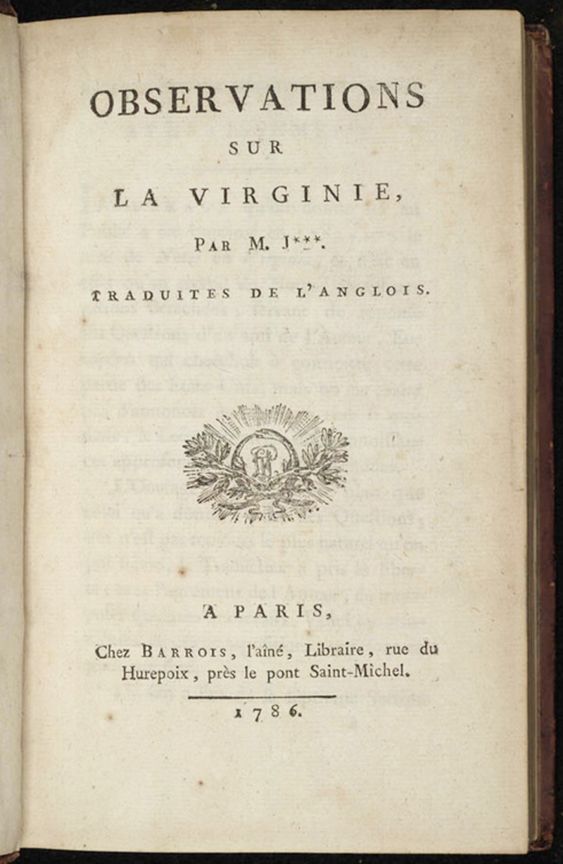
In spite of Jefferson’s efforts to limit distribution of his book, a French bookseller acquired a copy and decided to publish a French translation. A friend of Jefferson’s, Abbé André Morellet, discovered the unauthorized work and forestalled its publication. With Jefferson’s approval, Morellet took over the translation, and Jefferson authorized both French and English editions of his Notes to be published. Morellet also encouraged Jefferson to include a map with the book, which Jefferson agreed to do.
Still residing in Paris, Jefferson acquired contemporary maps of Virginia and the surrounding states in Paris and London, and compiled the information to create his own map. His sources included his father’s map of Virginia (A Map of the Most Inhabited Part of Virginia), William Scull’s 1770 map of Pennsylvania (A Map of Pennsylvania Exhibiting not only the Improved Parts of that Province, but also its Extensive Frontiers), Henry Mouzon’s 1775 map of North Carolina (An Accurate Map of North and South Carolina with their Indian Frontiers), and Thomas Hutchins’ 1778 map of western Virginia and the surrounding region (A New Map of the Western Parts of Virginia, Pennsylvania, Maryland, and North Carolina). In addition to these maps, he incorporated his own knowledge of the state, as well as information he was receiving from his colleagues back in his homeland. Despite the lack of any new surveys, Jefferson succeeded in creating the most accurate map of its time, and it remained the most up-to-date map until Bishop James Madison’s map 30 years later.
Notwithstanding his efforts, Jefferson elected to publish the map anonymously, which he explained in a letter to Edward Bancroft in February 1786: “I do not propose that my name shall appear on the map, because it will belong to it’s original authors, and because I do not wish to place myself at the bar of the public.” Jefferson wanted to give credit to the authors of the source maps he used, and also did not want to bear blame for any errors or omissions in the map.
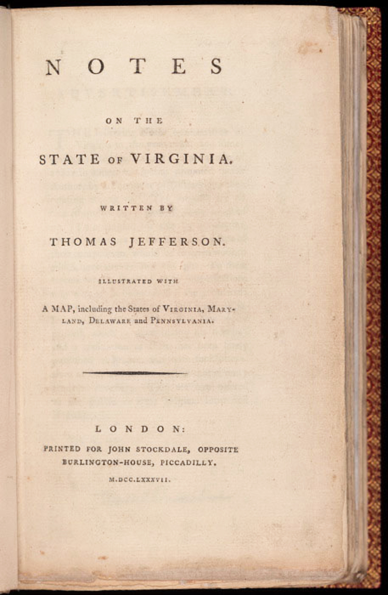
Jefferson completed the draft of his map and sent it to Samuel Neele in London for engraving, who received it in September 1786. Neele completed the engraved plate in December and dispatched it to Jefferson in Paris. Upon reviewing the copperplate, Jefferson and his secretary, William Short, discovered over 230 errors. Dissatisfied with the work, Jefferson engaged Parisian engraver Guillaume Delahaye to make the corrections, which were completed in March 1787 and 250 impressions were pulled from the plate. The plate was then sent to Barrois, who had already printed the French edition of the book, Observations sur la Virginie par M. J*** (still without Jefferson’s name), in 1786. Barrois made approximately 1,500 impressions and included the map in all further copies of the book that were sold. The plate then made its way back to London to John Stockdale, who was authorized to publish the English edition in 1787, which finally bore Jefferson’s name on the title page: Notes on the State of Virginia. Written by Thomas Jefferson. Stockdale pulled 1,025 impressions of the map to include in 1,000 copies of the book.
Image courtesy of the Tracy W. McGregor Library of American History.
Image courtesy of the Albert and Shirley Small Special Collections Library.
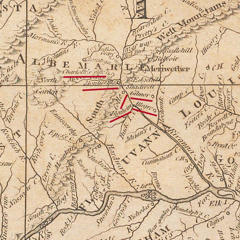
The map was titled A Map of the Country Between Albemarle Sound, and Lake Erie, centering on Virginia but extending to show the surrounding region. Beyond the fact that this was Jefferson’s only published map, it has historical significance for five geographical and political reasons. To begin with, it was the first map to show significant westward movement in Virginia since the Fry-Jefferson map 30 years prior, and it noted new settlements such as Charlottesville, Monticello, Gilmor, Blenheim, and Staunton. Showing the growth in the state was critical to encourage further settlement and commerce and give evidence to Virginia being a prosperous state with further potential.
A close-up of central Virginia, showing new settlements along the Rivanna River. (Image courtesy of Yale University Library, LC Maps of North America, 1750-1789, 762.)
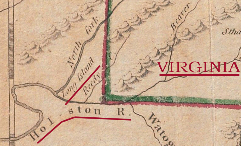
The second significant element was that Jefferson proposed a western boundary for Virginia. The portion of the western boundary that followed the Ohio River had already been accepted by Congress in 1784 based on Virginia’s cession of the region west of the river. The remainder of the western border that extended north-south was proposed by Jefferson as the optimal location for the Virginia border. The specific location was based on the 1770 Treaty of Lochaber between the British and the Cherokees, which set a western limit for colonial settlement in Virginia to avoid conflicts between settlers and Native Americans. The limit was set at six miles east of Long Island on the Holston River and extended due north to the mouth of the Kanawha River along the Ohio. In a letter to George Washington on March 15, 1784, Jefferson justified his reasons for that boundary line. He explained that Virginia could not effectively govern further west, however he wanted Virginia to retain two things: 1) its lead mines in the region; and 2) control of both sides of the Kanawha River for navigation and commerce. He also reasoned that the region west of the river was “a mountainous barren which can never be inhabited & will of course form a safe separation between us & any other state.” A true Virginian, Jefferson wanted to ensure that his native state would remain prosperous and also protected from western threats, even well after his governorship had ended.
The southwestern corner of Virginia, showing the boundary near Long Island along the Holston River. (Image courtesy of Yale University Library, LC Maps of North America, 1750-1789, 762.)
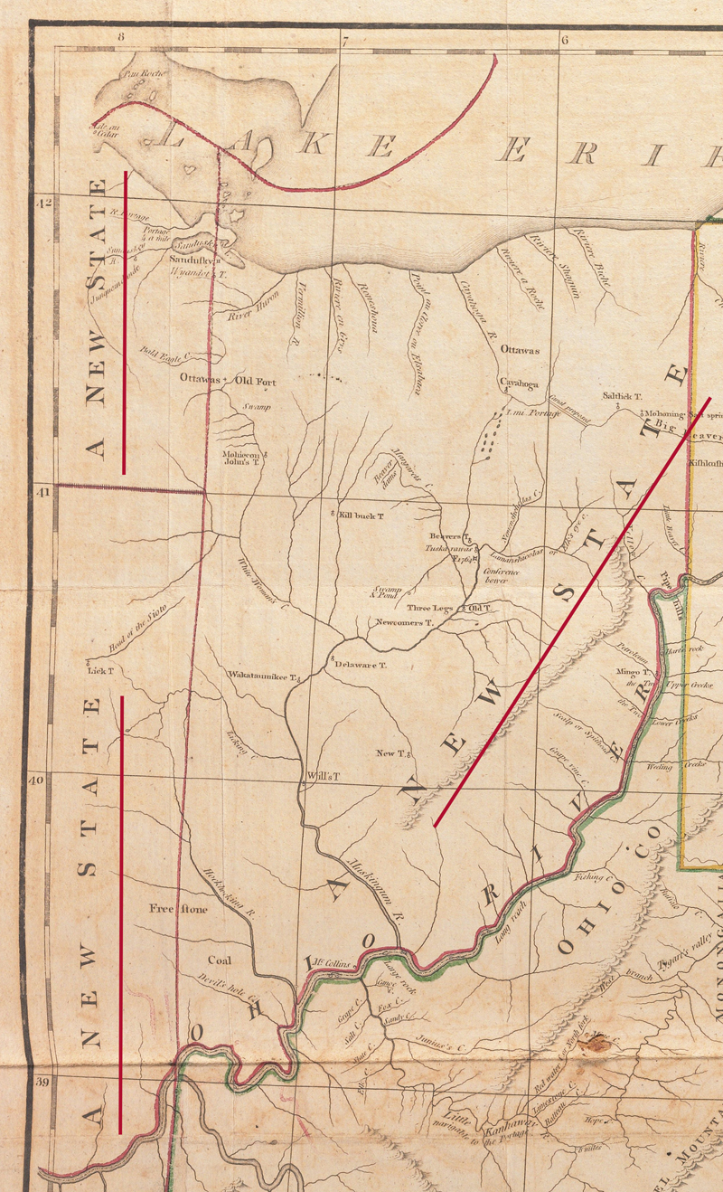
Thirdly, Jefferson suggested the boundaries for three new states west of the Ohio River, prior to the establishment of the Northwest Territory. Interestingly, he labeled each of these “A New State” without proposing specific names, despite the fact that he had submitted names for these states in a plan he prepared in March 1784 for a temporary government of this territory. In the plan, he recommended the names Washington, Saratoga and Metropotamia. Neither the boundary lines nor the names of these states came to fruition, however they exemplify Jefferson’s keen interest in the geographical development of the United States. And the fact that they are labeled “A New State” on the map is quite a unique feature – I am not aware of any other maps that use this term.
The region to the northwest of Virginia, west of the Ohio River, showing three new states. (Image courtesy of Yale University Library, LC Maps of North America, 1750-1789, 762.)
Due west of Virginia, Jefferson identified the proposed state of Kentucky, which had previously been a county of Virginia, and at the time he published his map was already a District. The state of Kentucky was not a new notion, as it had already appeared in John Filson’s Map of Kentucke in 1784, although it would not officially become a state until 1792.
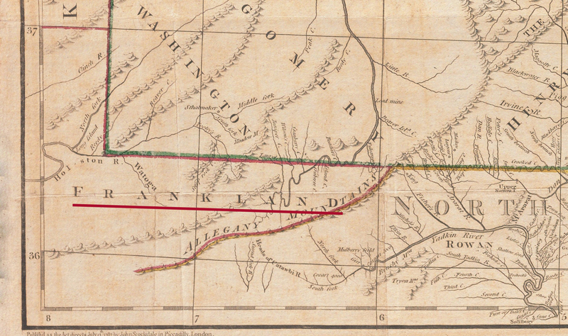
Jefferson also named and acknowledged a fifth new state just to the southwest of Virginia: Frankland. The state of Frankland, more commonly known as Franklin, was proposed by settlers in part of western North Carolina (present-day eastern Tennessee) to Congress in May 1785, although the settlers had already been acting as a de facto state as early as August 1784. The Franklinites, as they were known, were unhappy with the high taxes that were imposed upon them, coupled with a lack of protection and support from the North Carolina government. As a result, the settlers adopted a provisional Constitution in December 1784 under the name Franklin. “Franklin” was selected in honor of Benjamin Franklin, who was contacted by the delegation in the hope of gaining his support before Congress. Mr. Franklin would not officially endorse the new state, and instead encouraged the settlers to resolve their differences with North Carolina.
The alternate name “Frankland” that Jefferson applied on his map is believed to have originated with Arthur Campbell, a political leader in Virginia, who had attempted to create a larger new state from western portions of Virginia and North Carolina beginning in 1782. Campbell was unsuccessful in gaining enough traction in Virginia, and was therefore eager to assist the Franklinites in their efforts toward statehood in 1784. Campbell advocated for the name “Frankland,” derived from the English adjective “frank,” which originally meant “free,” to signify that the state would be a “Free Land.” When the Franklinites convened in November 1785 to formally adopt a Constitution, Campbell, along with Reverand Samuel Houston, proposed a new Constitution in the name of the “Freemen of the State of Frankland.” The Franklinites rejected the new name and the new Constitution and formally adopted the original Constitution. However, after repeated rejections from Congress and increasing tensions with North Carolina, the Franklinites finally abandoned their efforts to establish the state and swore allegiance to North Carolina in February 1789.
What is truly curious is why Jefferson used the term “Frankland” on his map instead of “Franklin.” He may have heard of Frankland from James Madison, with whom Jefferson corresponded frequently, and who had received a letter from Arthur Campbell regarding the proposed state of “Frankland” in October 1785. Whatever the connection was, Jefferson believed that Frankland would become a state, and his map was the very first printed map to identify the proposed state and one of only five to use the nomenclature of “Frankland.” In fact, there are only around 40 known printed maps to show the state of “Frankland” or “Franklin,” making this cartographic oddity prized among collectors. (Click here for the complete and newly updated carto-bibliography of maps depicting “Franklin” and “Frankland.”)
The state of "Frankland" to the southwest of Virginia. (Image courtesy of Yale University Library, LC Maps of North America, 1750-1789, 762.)
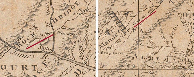
The final historically significant aspect of Jefferson’s map was the identification of natural features that had not previously been shown on maps. Jefferson had a strong interest in natural phenomena and described several of them in his Notes on the State of Virginia, including Natural Bridge and several caves. He located Natural Bridge, Madison’s Cave (between Augusta and Rockingham Counties), and Zane’s Cave (in Frederick County) on his map, none of which had previously appeared on a printed map.
Close-up images of Natural Bridge along the James River and Madison's Cave near Augusta County. (Image courtesy of Yale University Library, LC Maps of North America, 1750-1789, 762.)
Although A Map of the Country Between Albemarle Sound, and Lake Erie was his only published map, surveying and cartography were an integral part of Jefferson’s career. He proposed the “rectangular survey system” that was enacted into the Land Ordinance of 1785, which became the basis for the US Public Land Survey System. As Secretary of State under George Washington, he helped determine the location, orientation and layout of Washington, DC. As President, he was involved in several cartographic projects. He proposed the creation of the post for Surveyor General of the US and was also involved with creation of the US Coastal Survey. Jefferson was the driving force behind several expeditions to explore and map the territory acquired by the Louisiana Purchase, including those of Lewis & Clark and Dunbar-Hunter. After his presidency, he focused on his vision for public education in Virginia and was instrumental in the creation of the University of Virginia. He selected and surveyed the site for the university and was principal designer of the grounds plan and buildings. From his time as a young boy, learning surveying skills from his father, to his time as a statesman, helping to found a nation, Jefferson’s achievements were numerous and diverse. His contribution to the mapping of Virginia must not be disregarded and should be considered as one of his great accomplishments. Thomas Jefferson should be remembered as a statesman, diplomat, Founding Father, and cartographer.
REFERENCES
Alden, George Henry. “The State of Franklin.” American Historical Review, Vol. VIII No. 2 (January 1903), pp. 271–89.
Barksdale, Kevin T. “Upon the Shoulders of Giants: Deconstructing the Lost State of Franklin, 1784-2005.” PhD dissertation, West Virginia University, 2005.
Hallisey, Jane. “Thomas Jefferson, Cartographer: A Father’s Legacy to his Renaissance Son.” Mercator’s World, Vol. 1 No. 3 (1996), pp. 22-27.
Keedy, Edwin R. “The Constitutions of the State of Franklin, the Indian Stream Republic and the State of Deseret.” University of Pennsylvania Law Review, Vol. 101 (1953), pp. 516-528.
Kovarsky, Joel. The True Geography of our Country: Jefferson’s Cartographic Vision. Charlottesville: University of Virginia Press, 2014.
McGill, J.T. “Franklin and Frankland – Names and Boundaries.” Tennessee Historical Magazine, Vol. I, No. 4 (January 1925), pp. 248-57.
National Archives and Records Administration. “Founders Online.” Accessed February 15, 2024. https://founders.archives.gov/.
Verner, Coolie. A Further Checklist of the Separate Editions of Jefferson's Notes on the State of Virginia. Charlottesville: Bibliographical Society of the University of Virginia, 1950.
Verner, Coolie. “Mr. Jefferson Makes a Map.” Imago Mundi, Vol. 14 (1959), pp. 96-108.
Verner, Coolie. “The Maps and Plates Appearing with the Several Editions of Mr. Jefferson’s ‘Notes on the State of Virginia.’” The Virginia Magazine of History and Biography, Vol. 59, No. 1 (January 1951), pp. 21-33.
William L. Clements Library. Thomas Jefferson, 1743-1943: a Guide to the Rare Books, Maps & Manuscripts Exhibited at the University of Michigan. Ann Arbor: The William L. Clements Library, 1943.
Williams, Samuel Cole. History of the Lost State of Franklin. Johnson City, Tennessee: The Watauga Press, 1924.