Filtered by Category:Atlantic & Arctic(Show All Categories)
Catalog Archive
1162 lots
Page 1 of 24
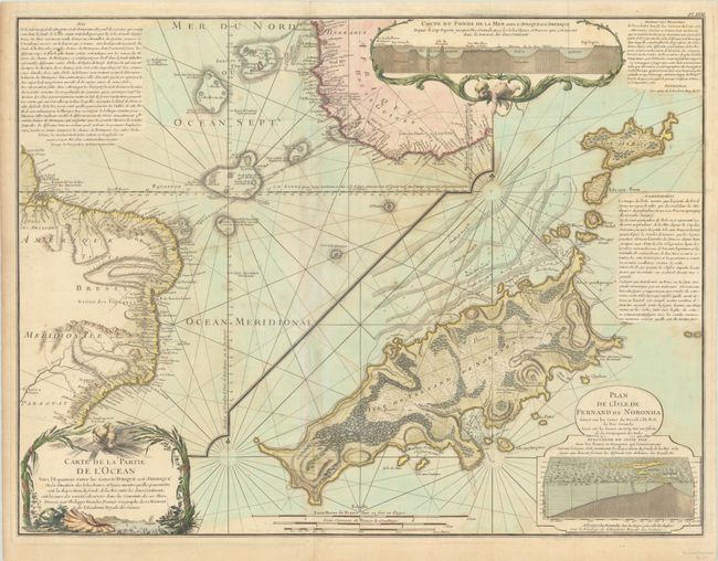
Auction 197, Lot 392
Subject: Atlantic Ocean
Buache/Dezauche
Carte de la Partie de l'Ocean Vers l'Equateur Entre les Cotes d'Afrique et d'Amerique... [on sheet with] Plan de l'Isle de Fernand de Noronha…, 1780
Size: 25.1 x 19.1 inches (63.8 x 48.5 cm)
Estimate: $350 - $425
Map Promoting Theory of Undersea Mountains
Sold for: $300
Closed on 4/24/2024
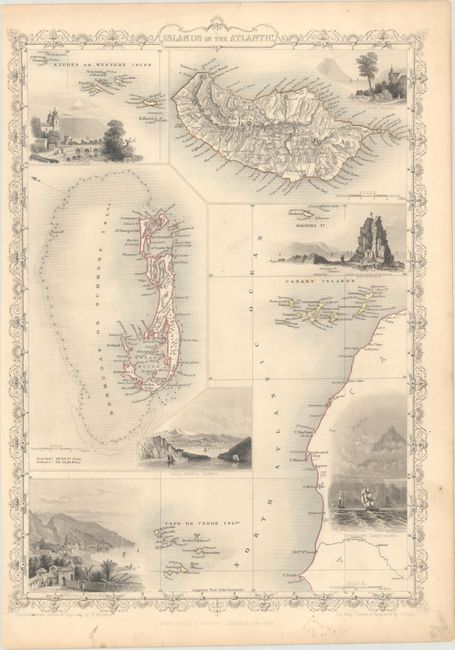
Auction 197, Lot 393
Subject: Atlantic Islands
Tallis, John
Islands in the Atlantic, 1851
Size: 9.9 x 13.9 inches (25.1 x 35.3 cm)
Estimate: $75 - $95
Sold for: $55
Closed on 4/24/2024
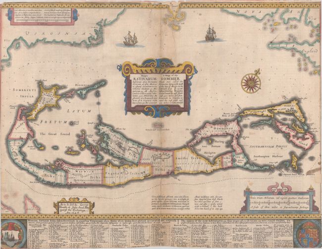
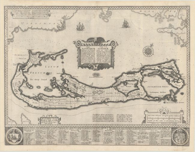
Auction 197, Lot 394
Subject: Bermuda
Speed, John
Mappa Aestivarum Insularum Alias Bermudas Dictarum... / A Mapp of the Sommer Islands Once Called the Bermudas..., 1626
Size: 20.4 x 15.7 inches (51.8 x 39.9 cm)
Estimate: $1,400 - $1,700
Speed's Foundation Map of Bermuda
Unsold
Closed on 4/24/2024
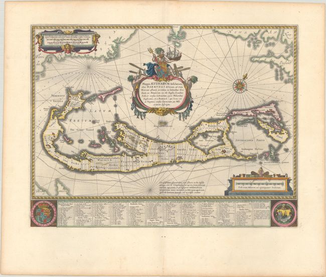
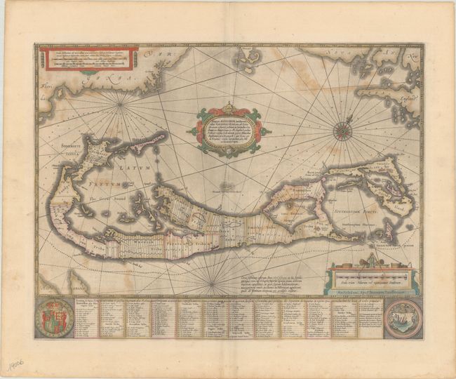
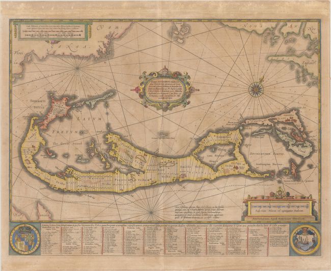
Auction 197, Lot 395
Subject: Bermuda
Blaeu, Willem
Mappa Aestivarum Insularum, Alias Barmudas Dictarum, ad Ostia Mexicani Aestuary..., 1642
Size: 21 x 15.9 inches (53.3 x 40.4 cm)
Estimate: $1,600 - $1,900
Map of Bermuda Based on Richard Norwood's Famous Survey in Full Contemporary Color
Sold for: $900
Closed on 4/24/2024
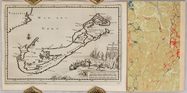
Auction 197, Lot 396
Subject: Bermuda
Aa, Pieter van der
[Map in Disbound Book] De Bermudes of Summer Eylanden tot de Reystogten... [in] Kort Berigt van Mr. Ellis, een der Kapiteynen van d'Heer Richard Hawkins ... Reys door de Straat van Magellanes in 't Jaar 1593... , 1706
Size: 9.1 x 6.1 inches (23.1 x 15.5 cm)
Estimate: $1,200 - $1,500
Price reduced by $200!
Unsold
Closed on 4/24/2024
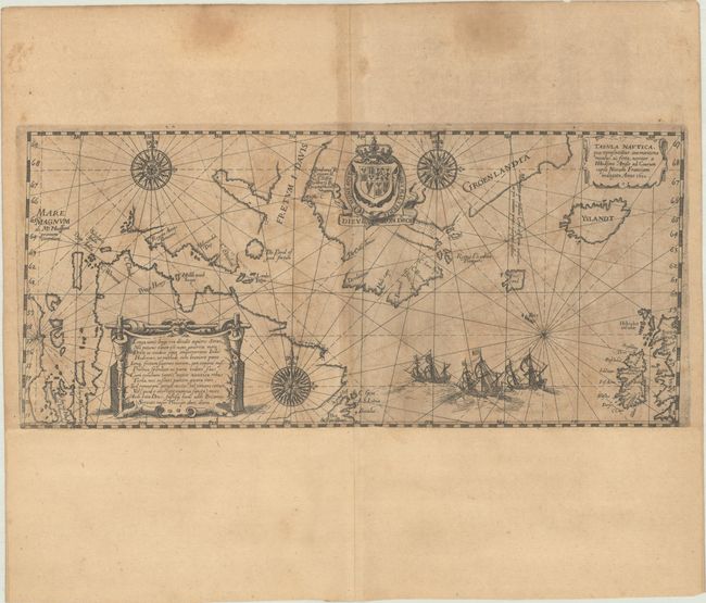
Auction 197, Lot 397
Subject: North Atlantic
Bry, Johann Theodore de
Tabula Nautica, qua Repraesentatur Orae Maritimae Meatus, ac Freta, Noviter a H Hudsono Anglo ad Caurum Supra Novam Franciam Indagata Anno 1612, 1613
Size: 13.1 x 5.9 inches (33.3 x 15 cm)
Estimate: $1,400 - $1,700
De Bry's Scarce and Decorative Chart Showing Hudson's Search for a Northwest Passage
Sold for: $1,900
Closed on 4/24/2024

Auction 197, Lot 398
Subject: North Atlantic
Carte Generale des Royaumes, Etats et Domaines, que les Rois et la Couronne de la Grande-Bretagne ont Possedez ou Possedent en Europe eb Afrique et en Amerique, 1740
Size: 19.2 x 14.4 inches (48.8 x 36.6 cm)
Estimate: $350 - $425
Price reduced by $55
Unsold
Closed on 4/24/2024
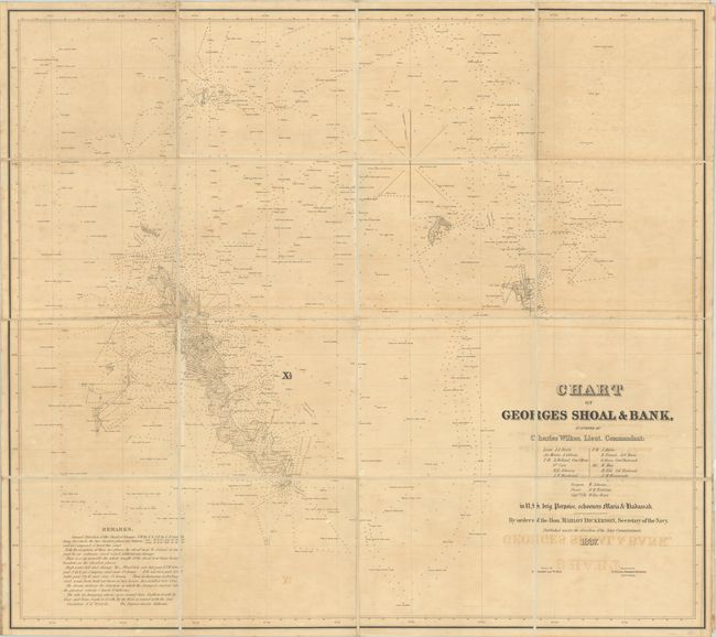
Auction 197, Lot 399
Subject: North Atlantic
Wilkes, Charles
Chart of Georges Shoal & Bank, Surveyed by Charles Wilkes, Lieut. Commandant..., 1837
Size: 43.9 x 39 inches (111.5 x 99.1 cm)
Estimate: $550 - $700
Sold for: $400
Closed on 4/24/2024
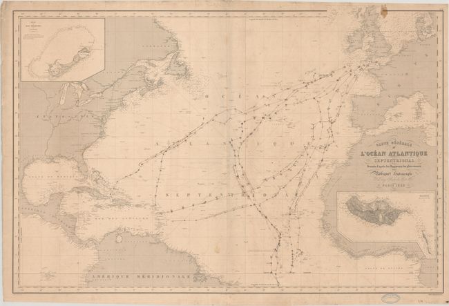
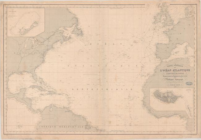
Auction 197, Lot 400
Subject: North Atlantic
Robiquet, Aime
Carte Generale l'Ocean Atlantique Septentrional Dressee d'Apres les Documents les Plus Recents, 1855
Size: 39.5 x 27.2 inches (100.3 x 69.1 cm)
Estimate: $300 - $375
Price reduced by $45
Unsold
Closed on 4/24/2024
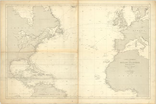
Auction 197, Lot 401
Subject: North Atlantic
Direccion de Hidrografia
Carta General del Oceano Atlantico Septentrional, 1872
Size: 36.6 x 23.8 inches (93 x 60.5 cm)
Estimate: $240 - $300
Price reduced by $30
Unsold
Closed on 4/24/2024
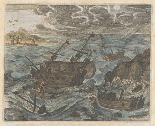
Auction 197, Lot 402
Subject: Bay of Biscay
Bry, Theodore de
[Untitled - John Smith Is Caught by the French], 1631
Size: 6.8 x 5.4 inches (17.3 x 13.7 cm)
Estimate: $110 - $140
Price reduced by $10
Sold for: $70
Closed on 4/24/2024
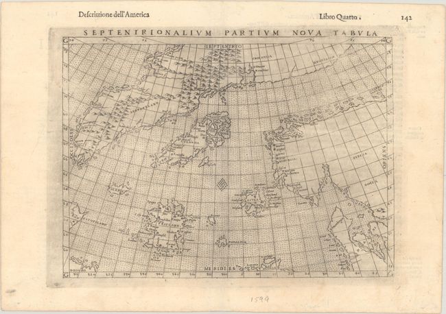
Auction 197, Lot 403
Subject: Arctic & Scandinavia
Ruscelli, Girolamo
Septenirionalium Partium Nova Tabula, 1599
Size: 9.4 x 6.9 inches (23.9 x 17.5 cm)
Estimate: $600 - $750
Sold for: $325
Closed on 4/24/2024
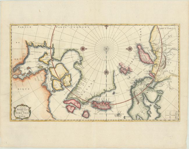
Auction 197, Lot 404
Subject: Arctic
Bernard, Jean Frederic
Carte du Nord Est & du Nord West du Pole, 1717
Size: 22.8 x 13.1 inches (57.9 x 33.3 cm)
Estimate: $550 - $700
Sold for: $400
Closed on 4/24/2024
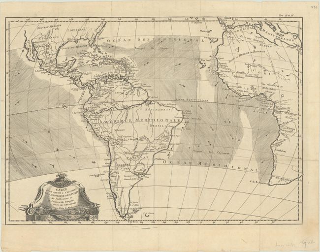
Auction 196, Lot 356
Subject: Atlantic Ocean & South America
Bonne, Rigobert
Carte pour Servir a l'Histoire Philosophique et Politique des Etablissemens et du Commerce des Europeens dans les Deux Indes, 1780
Size: 18.3 x 12.8 inches (46.5 x 32.5 cm)
Estimate: $140 - $170
Sold for: $70
Closed on 2/7/2024
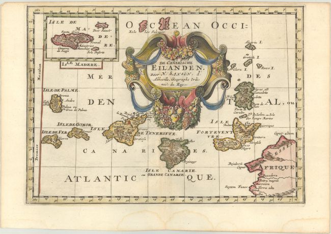
Auction 196, Lot 357
Subject: Canary Islands
Sanson, Nicolas
De Canarische Eilanden, 1705
Size: 10.5 x 7.5 inches (26.7 x 19.1 cm)
Estimate: $110 - $140
Sold for: $85
Closed on 2/7/2024
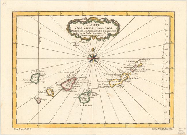
Auction 196, Lot 358
Subject: Canary Islands
Bellin, Jacques Nicolas
Carte des Isles Canaries. Dressee sur les Journaux des Navigateurs, 1746
Size: 11.1 x 8 inches (28.2 x 20.3 cm)
Estimate: $80 - $95
Sold for: $60
Closed on 2/7/2024
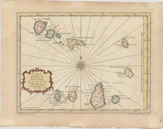
Auction 196, Lot 359
Subject: Cape Verde Islands
Bellin, Jacques Nicolas
Carte des Isles du Cap Verd Dressee sur les Journaux et les Remarques des Plus Habiles Navigateurs, 1746
Size: 11.1 x 8.4 inches (28.2 x 21.3 cm)
Estimate: $60 - $75
NO RESERVE
Sold for: $60
Closed on 2/7/2024
Auction 196, Lot 360
Subject: Bermuda
Speed, John
Mappa Aestivarum Insularum Alias Bermudas Dictarum... / A Mapp of the Sommer Islands Once Called the Bermudas..., 1626
Size: 20.8 x 15.8 inches (52.8 x 40.1 cm)
Estimate: $1,200 - $1,500
Speed's Foundation Map of Bermuda
Sold for: $1,400
Closed on 2/7/2024
Auction 196, Lot 361
Subject: Bermuda
Hondius/Jansson
Mappa Aestivarum Insularum, Alias Barmudas Dictarum, ad Ostia Mexicani Aestuary..., 1644
Size: 20.3 x 15.5 inches (51.6 x 39.4 cm)
Estimate: $800 - $950
Full Contemporary Color
Sold for: $600
Closed on 2/7/2024
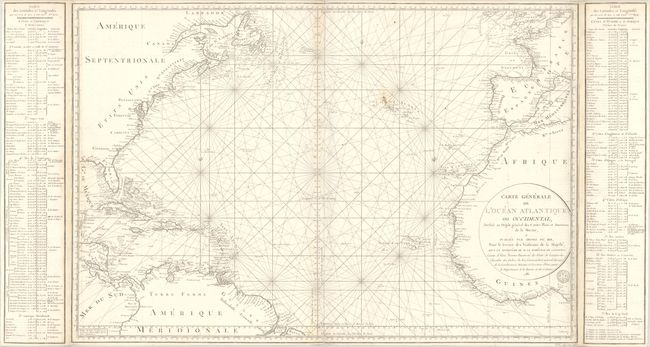
Auction 196, Lot 362
Subject: North Atlantic
Robiquet, Aime
Carte Generale l'Ocean Atlantique Septentrional Dressee d'Apres les Documents les Plus Recents, 1855
Size: 39.5 x 27.2 inches (100.3 x 69.1 cm)
Estimate: $400 - $475
Unsold
Closed on 2/7/2024
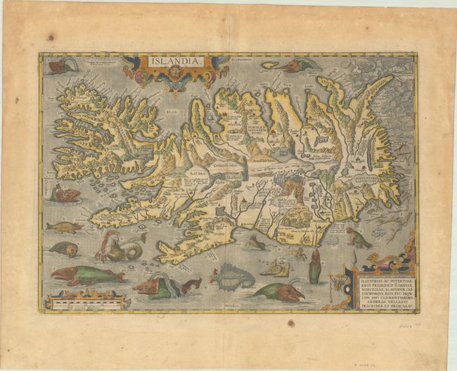
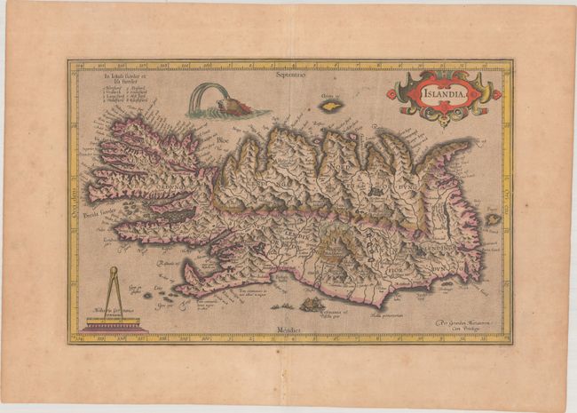
Auction 196, Lot 363
Subject: Iceland
Ortelius, Abraham
Islandia, 1585
Size: 19.4 x 13.3 inches (49.3 x 33.8 cm)
Estimate: $9,500 - $12,000
One of Ortelius' Most Decorative Maps
Sold for: $8,000
Closed on 2/7/2024
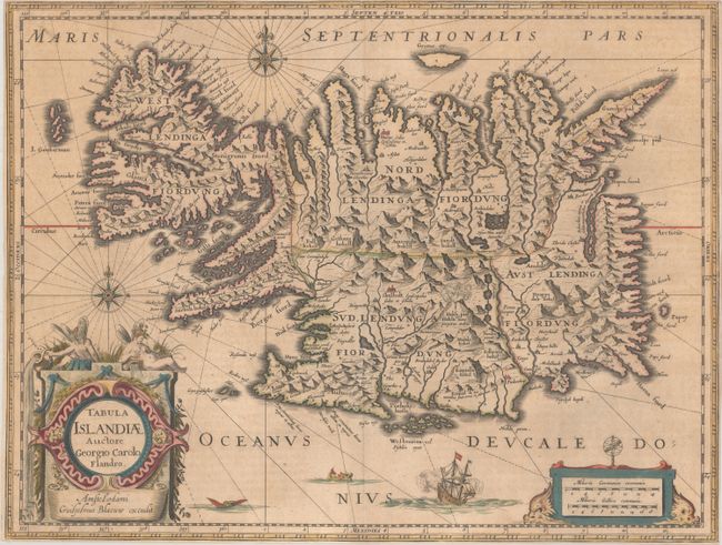
Auction 196, Lot 364
Subject: Iceland
Hondius/Blaeu
Tabula Islandiae Auctore Georgio Carolo Flandro, 1644
Size: 19.6 x 15 inches (49.8 x 38.1 cm)
Estimate: $475 - $600
Sold for: $400
Closed on 2/7/2024

Auction 195, Lot 423
Subject: Atlantic Islands
Tallis, John
Islands in the Atlantic, 1851
Size: 9.9 x 13.9 inches (25.1 x 35.3 cm)
Estimate: $110 - $140
Unsold
Closed on 11/15/2023
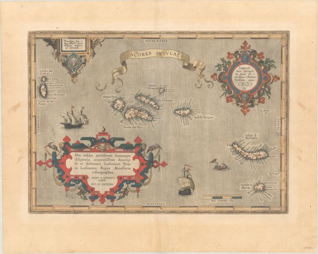
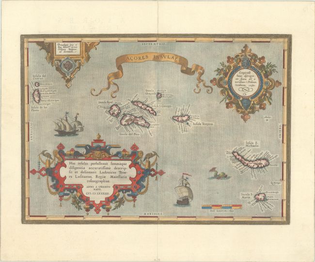
Auction 195, Lot 424
Subject: Azores
Ortelius, Abraham
Acores Insulae, 1584
Size: 18.3 x 12.9 inches (46.5 x 32.8 cm)
Estimate: $550 - $700
Sold for: $550
Closed on 11/15/2023
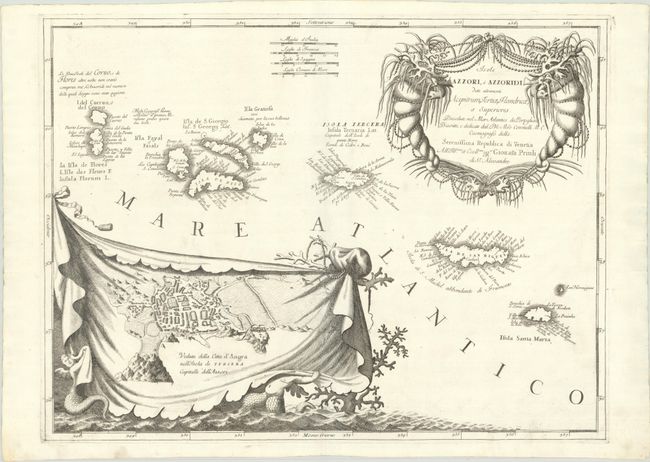
Auction 195, Lot 425
Subject: Azores
Coronelli, Vincenzo Maria
Isole Azzori, o Azzoridi dette Altrimenti Acipitrum, Tertiae, Flandricae, et Superiores..., 1690
Size: 23.5 x 17.7 inches (59.7 x 45 cm)
Estimate: $500 - $650
Unsold
Closed on 11/15/2023
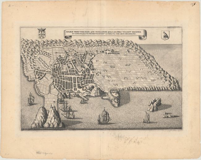
Auction 195, Lot 426
Subject: Terciera, Azores
Merian, Matthaus
Angrae Urbis Tercerae que Insularum quas Azores Vocant Maxima et Copioso Glasti Proventu Ditissa Accurata cum Arce Delineatio, 1638
Size: 12.8 x 8.1 inches (32.5 x 20.6 cm)
Estimate: $240 - $300
Sold for: $80
Closed on 11/15/2023

Auction 195, Lot 427
Subject: St. Helena
Linschoten, Jan Juygen van
Insula D. Helenae Sacra Coeli Clementia et Aequabilitate..., 1589
Size: 19.9 x 14.5 inches (50.5 x 36.8 cm)
Estimate: $350 - $425
Sold for: $250
Closed on 11/15/2023
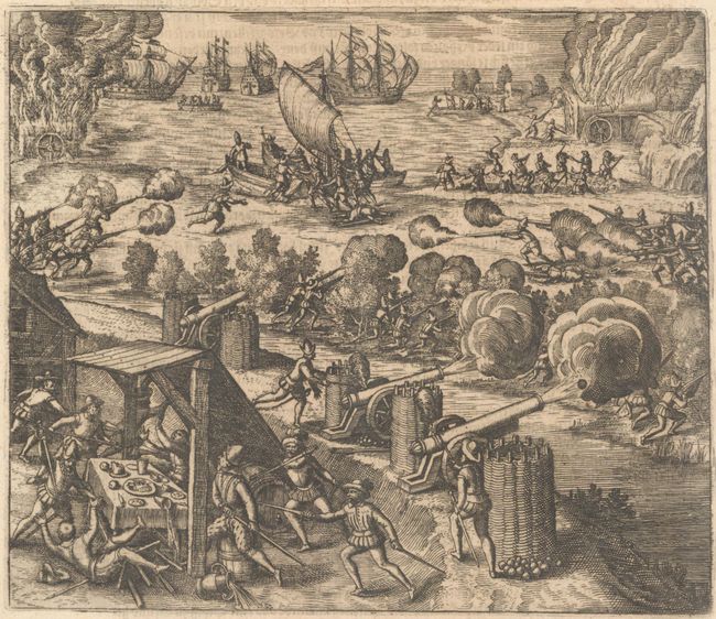
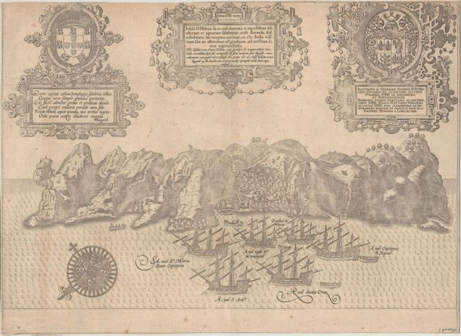
Auction 195, Lot 428
Subject: Gran Canaria
Gottfried, J.L.
[Lot of 2] [The Dutch Fleet Attack the Spanish Fortress of Gratiosa on Gran Canaria] [and] [Attack of Dutch Fleet Commanded by Pieter van der Does Sacking Gran Canaria in 1599], 1655
Size: 7.1 x 6 inches (18 x 15.2 cm)
Estimate: $140 - $170
Sold for: $75
Closed on 11/15/2023
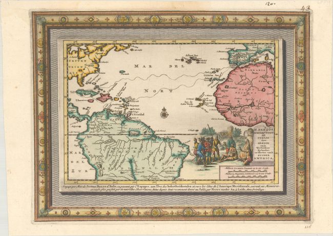
Auction 195, Lot 429
Subject: North Atlantic
Aa, Pieter van der
H. Benzos Scheep-Togt uit Italie over Spanje na de Westindize Eylanden, en Kusten van't Zuider America, 1707
Size: 11.3 x 8.6 inches (28.7 x 21.8 cm)
Estimate: $350 - $425
Sold for: $250
Closed on 11/15/2023
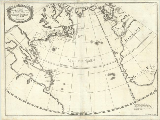
Auction 195, Lot 430
Subject: North Atlantic
Carte Generale des Royaumes, Etats et Domaines, que les Rois et la Couronne de la Grande-Bretagne ont Possedez ou Possedent en Europe eb Afrique et en Amerique, 1740
Size: 19.2 x 14.4 inches (48.8 x 36.6 cm)
Estimate: $400 - $475
Price reduced by $55
Unsold
Closed on 11/15/2023
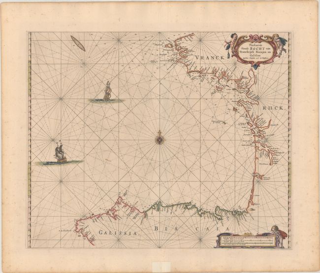
Auction 195, Lot 431
Subject: Bay of Biscay
Goos, Pieter
Paskaerte vande Bocht van Vranckrijck Biscajen en Galissen Tusschen Heyssant en C. de Finisterre, 1666
Size: 21.6 x 17.7 inches (54.9 x 45 cm)
Estimate: $350 - $425
Sold for: $250
Closed on 11/15/2023
Auction 194, Lot 369
Subject: Azores
Ortelius, Abraham
Acores Insulae, 1584
Size: 18.3 x 13 inches (46.5 x 33 cm)
Estimate: $550 - $700
Sold for: $425
Closed on 9/13/2023

Auction 194, Lot 370
Subject: Bermuda
Speed, John
Mappa Aestivarum Insularum Alias Bermudas Dictarum... / A Mapp of the Sommer Islands Once Called the Bermudas..., 1626
Size: 20.8 x 15.8 inches (52.8 x 40.1 cm)
Estimate: $1,600 - $1,900
Speed's Foundation Map of Bermuda
Unsold
Closed on 9/13/2023

Auction 194, Lot 371
Subject: Bermuda
Hondius/Jansson
Mappa Aestivarum Insularum, Alias Barmudas Dictarum, ad Ostia Mexicani Aestuary..., 1644
Size: 20.3 x 15.5 inches (51.6 x 39.4 cm)
Estimate: $1,000 - $1,300
Full Contemporary Color
Unsold
Closed on 9/13/2023
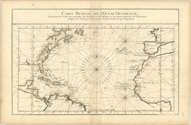
Auction 194, Lot 372
Subject: North Atlantic
Buy de Mornas, Claude
Carte Reduite de l'Ocean Occidental, Contenant les Cotes Occidentales de l'Europe et de l'Afrique, et les Cotes Orientales de l'Amerique..., 1761
Size: 17.9 x 11.6 inches (45.5 x 29.5 cm)
Estimate: $120 - $160
NO RESERVE
Sold for: $160
Closed on 9/13/2023
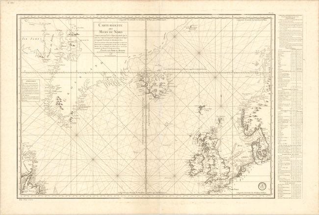
Auction 194, Lot 373
Subject: North Atlantic
Verdun de la Crenne
Carte Reduite des Mers du Nord..., 1776
Size: 31.1 x 22.3 inches (79 x 56.6 cm)
Estimate: $325 - $400
Sold for: $190
Closed on 9/13/2023
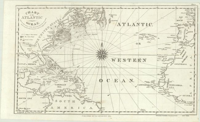
Auction 194, Lot 374
Subject: North Atlantic
Blunt, Edmund
Chart of the Atlantic Ocean. With an Illustration of the Character and Rout of a Storm Which Occurred on the American Coast in August 1830, 1831
Size: 12.5 x 7.6 inches (31.8 x 19.3 cm)
Estimate: $140 - $170
Sold for: $100
Closed on 9/13/2023
Auction 194, Lot 375
Subject: Iceland
Mercator, Gerard
Islandia, 1609
Size: 17.3 x 11.1 inches (43.9 x 28.2 cm)
Estimate: $600 - $750
Sold for: $300
Closed on 9/13/2023
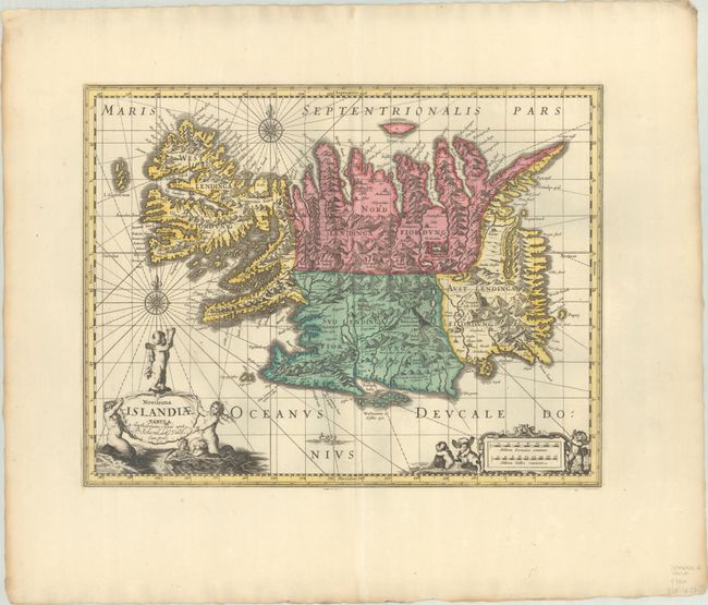
Auction 194, Lot 376
Subject: Iceland
Blaeu/Valck & Schenk
Novissima Islandiae Tabula, 1700
Size: 19 x 14.7 inches (48.3 x 37.3 cm)
Estimate: $750 - $900
Sold for: $550
Closed on 9/13/2023
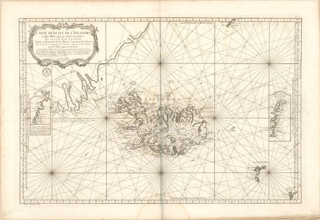
Auction 194, Lot 377
Subject: Iceland
Bellin, Jacques Nicolas
Carte Reduite de l'Islande et des Mers qui en sont Voisines. Pour Servir a la Pesche de la Balaine..., 1767
Size: 32.9 x 21.6 inches (83.6 x 54.9 cm)
Estimate: $400 - $475
Sold for: $300
Closed on 9/13/2023
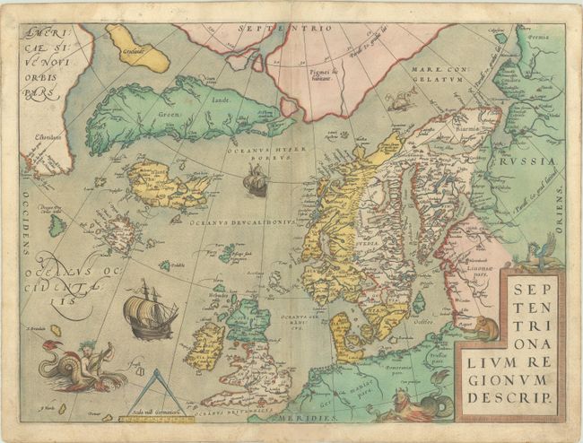
Auction 194, Lot 378
Subject: Arctic & Northern Europe
Ortelius, Abraham
Septentrionalium Regionum Descrip., 1572
Size: 19.4 x 14.3 inches (49.3 x 36.3 cm)
Estimate: $2,300 - $2,750
Early Example of Ortelius' Map of the Arctic with Mythical Islands in Contemporary Color
Sold for: $2,300
Closed on 9/13/2023
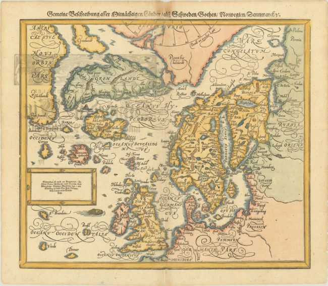
Auction 194, Lot 379
Subject: Arctic & Northern Europe
Munster, Sebastian
Gemeine Beschreibung aller Mitnachtigen Lander / alsz Schweden / Gothen / Norwegien / Dennmarck / &c., 1588
Size: 14.2 x 12.3 inches (36.1 x 31.2 cm)
Estimate: $700 - $850
Sold for: $600
Closed on 9/13/2023
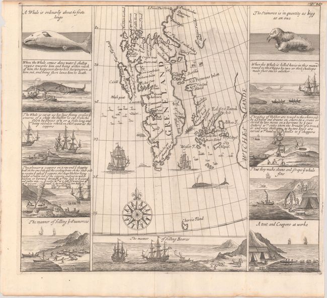
Auction 194, Lot 380
Subject: Spitsbergen
Purchas, Samuel
[Greneland], 1704
Size: 12.8 x 11.4 inches (32.5 x 29 cm)
Estimate: $950 - $1,200
Important Whaling Map of Spitsbergen
Sold for: $650
Closed on 9/13/2023

Auction 193, Lot 378
Subject: Azores
Coronelli, Vincenzo Maria
Isole Azzori, o Azzoridi dette Altrimenti Acipitrum, Tertiae, Flandricae, et Superiores..., 1690
Size: 23.5 x 17.7 inches (59.7 x 45 cm)
Estimate: $550 - $650
Unsold
Closed on 6/21/2023
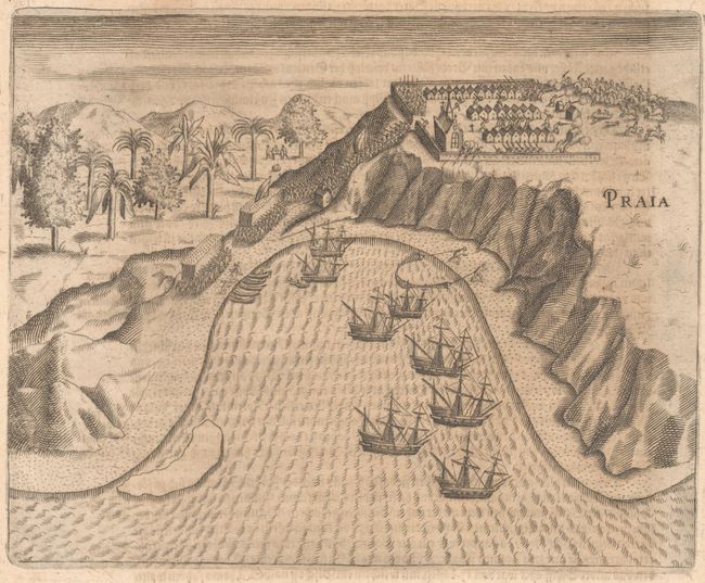
Auction 193, Lot 379
Subject: Cape Verde Islands
Bry, Theodore de
[The Dutch Attacks the Fortress at Praia] Praia, 1655
Size: 7.4 x 5.9 inches (18.8 x 15 cm)
Estimate: $120 - $150
NO RESERVE
Sold for: $55
Closed on 6/21/2023
Auction 193, Lot 380
Subject: St. Helena
Linschoten, Jan Juygen van
Insula D. Helenae Sacra Coeli Clementia et Aequabilitate..., 1589
Size: 19.9 x 14.5 inches (50.5 x 36.8 cm)
Estimate: $400 - $475
Unsold
Closed on 6/21/2023
Auction 193, Lot 381
Subject: Bermuda
Hondius, Henricus
Mappa Aestivarum Insularum, Alias Barmudas Dictarum, ad Ostia Mexicani Aestuary..., 1639
Size: 20.4 x 15.5 inches (51.8 x 39.4 cm)
Estimate: $800 - $950
Sold for: $600
Closed on 6/21/2023
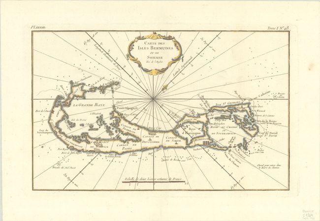
Auction 193, Lot 382
Subject: Bermuda
Bellin, Jacques Nicolas
Carte des Isles Bermudes ou de Sommer Tire de l'Anglois, 1768
Size: 13.1 x 8.1 inches (33.3 x 20.6 cm)
Estimate: $400 - $500
Sold for: $300
Closed on 6/21/2023
Auction 193, Lot 383
Subject: North Atlantic
Depot de la Marine
Carte Generale de l'Ocean Atlantique ou Occidental, Dressee au Depot General des Cartes Plans et Journaux de la Marine..., 1786
Size: 45.5 x 24.5 inches (115.6 x 62.2 cm)
Estimate: $240 - $300
Sold for: $120
Closed on 6/21/2023
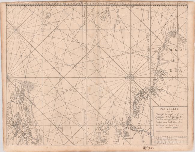
Auction 193, Lot 384
Subject: Western Atlantic Ocean
Colom, Jacob Aertz
Pas-Caarte van de Canarise, Vlaemse, en Groen-Eylanden, tot de Caribse Eylanden, mitsgaders de Zee-Custen vant Vaste Lant daer Bezuyden en Benoorden, 1663
Size: 21 x 16.6 inches (53.3 x 42.2 cm)
Estimate: $450 - $550
Unsold
Closed on 6/21/2023
1162 lots
Page 1 of 24