Subject: Iceland
Period: 1700 (circa)
Publication:
Color: Hand Color
Size:
19 x 14.7 inches
48.3 x 37.3 cm
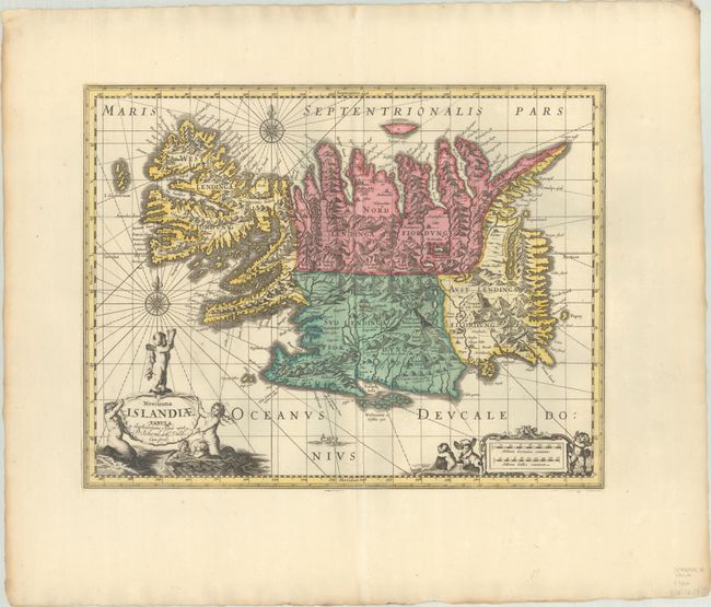
This handsome copper engraved map of Iceland was based on information from a Dutch navigator named Joris Carolus in about 1620. The map shows the influence of both versions of Bishop Gudbrandur's previous maps, a coastline resembling the Ortelius version, and Mercator's selection and spelling of many place names. The island's topography is dominated by huge mountains and volcanoes and its shoreline is a rugged labyrinth of fiords. It is richly embellished with title and distance scale cartouches, compass roses, rhumb lines, and a sea monster. The map was first issued by Jodocus Hondius, re-issued by Willem Blaeu, and then re-issued by Moses Pitt in 1680 with numerous changes, including a complete re-engraving of the two cartouches, a new title, elimination of a sea monster and a sailing ship, and the addition of a graticule. The new cartouches feature putti and mer-people, with the title emblazoned on a large shell. The map finally passed on to Pieter Schenk and Gerard Valck, who issued it with their imprint replacing that of Pitt. This map was the prototype for the mapping of Iceland at the time and its influence did not wane until the mid-18th century.
References: cf. Van der Krogt (Vol. I) #1250:1B.2.
Condition: A+
A sharp impression with full contemporary color on a bright sheet with wide margins. There are two tiny worm holes in the image and light soiling along the edges of the sheet.