Subject: North Atlantic
Period: 1613 (circa)
Publication: Petits Voyages, Part X
Color: Black & White
Size:
13.1 x 5.9 inches
33.3 x 15 cm
This copper engraving is from a remarkable series of publications, illustrating voyages of discovery and travels of exploration to various parts of the world. The project was begun by Theodore de Bry of Frankfurt, in 1590 and was to continue for another 54 years. They became known collectively as the Grands Voyages (to America and the West Indies) and the Petits Voyages (to the Orient and the East Indies). De Bry died after the first six parts of the Grands Voyages were completed. The project was completed initially by his widow and two sons, Johann Theodore de Bry and Johann Israel de Bry, then by Johann Theodore's son-in-law, Matthaus Merian, in 1624.
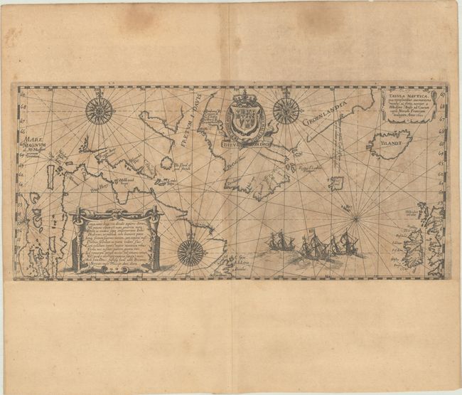
This scarce sea chart of the North Atlantic was created by De Bry, after Hessel Gerritz' extremely rare map of 1612. This map depicts the fourth and final voyage of Henry Hudson in his hunt for a Northwest Passage, during which he was set adrift after his crew mutinied following a brutal winter and thus was never seen again. There were only eight people from the crew who made it back to England in September of 1611, and with them came the information for this map. This map records Hudson's belief that he had found the Pacific Ocean with the Mare Magnum named at far left; this was later named Hudson Bay. What would become James Bay is shown erroneously with two large bays of its own. The mythical island of Frisland is located to the southwest of Iceland and south of Greenland. There is also a partial coastline labeled Bus, a reference to the phantom Buss Island that was spotted on Martin Frobisher's third voyage in 1585. A dedicatory epigraph to Hudson appears at bottom left on a cartouche designed to look like stretched animal skin. A landmark map in the exploration of the North Sea and the Arctic, it is adorned with a trio of beautiful compass roses, rhumb lines, a decorative title cartouche, three sailing ships, and the royal crest of Britain.
References: Burden #165; Kershaw #55.
Condition: B
A dark impression on a moderately toned sheet with a coat of arms watermark. A short tear in the compass rose at bottom has been archivally repaired on verso, and there are a couple dampstains and a few tiny edge tears confined to the blank margins. Professionally remargined at bottom with period-correct paper.