Subject: North Atlantic
Period: 1786 (dated)
Publication:
Color: Black & White
Size:
45.5 x 24.5 inches
115.6 x 62.2 cm
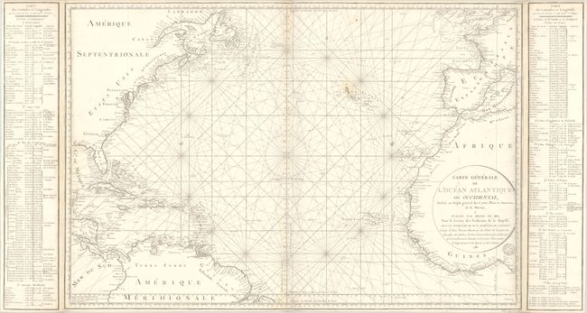
This large-scale chart of the North Atlantic shows the northeast coast of North America, the West Indies, Central America and the northern coast of South America. Opposite it covers the coastlines of Europe and northwestern Africa. The center of the chart is crossed with rhumb lines on 17 centers, radiating across the Atlantic with the prime meridian running just west of the Canary Islands. Tables of latitude and longitude flank the map, which were printed on separate sheets and pasted on to the map. The engraved seal of the Depot de la Marine appears below the title, with the price at bottom right: "Prix Quarante Sol." Printed on two sheets, joined. The map itself measures 36 x 24".
References:
Condition: B+
A crisp impression on a sturdy, watermarked sheet, issued folding with light soiling, some small stains by the Azores, and light toning along the side folds. There are a few short fold separations along the edges of the sheet that have been closed on verso with archival tape.