Subject: Bay of Biscay
Period: 1666 (circa)
Publication:
Color: Hand Color
Size:
21.6 x 17.7 inches
54.9 x 45 cm
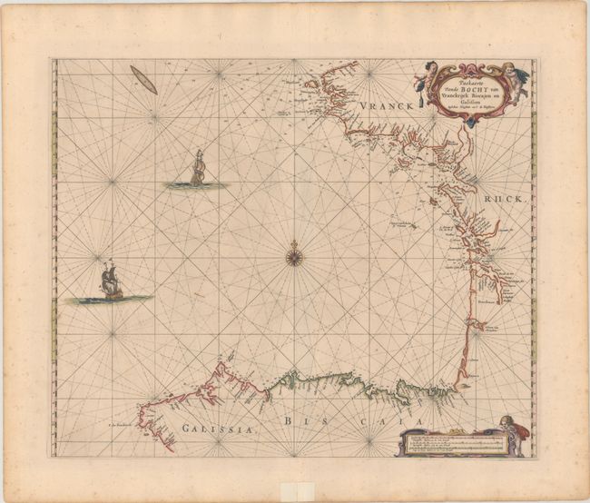
This elegantly engraved sea chart of the Bay of Biscay was first published in Goos' De Zee-Atlas, Ofte Water-Weereld (1666). It spans the coastline from Brest, France, south to Cape Finisterre, Spain. Most of the detail is focused on river inlets, navigational hazards, anchorages, and depth soundings. The chart is crisscrossed with rhumb lines and centered on a compass rose. Two sailing ships and strapwork title and distance scale cartouches flanked by putti complete the composition.
During the Golden Age of Dutch mapmaking, only the firms of Blaeu and van Keulen were as respected as the publishing house of Pieter Goos. Based in Amsterdam, Goos was one of the preeminent publishers of nautical charts. His maritime atlas of the world was one of the most complete sea atlases published prior to the appearance of Van Keulen's Zee-Fakkel in the 1680s.
References: cf. Mickwitz & Miekkavaara #80-17; Putnam, Early Sea Charts, pp. 99-100.
Condition: B+
A nice impression on a sturdy sheet with full contemporary color and gilt highlights. There is minor foxing, a couple short printer's creases, and a pair of small wormholes adjacent to the centerfold at bottom. In the bottom blank margin, there is a short centerfold separation and a remnant of hinge tape.