Showing Unsold Lots $100 to $250(remove filter)
Current Auction
186 lots
Page 1 of 4
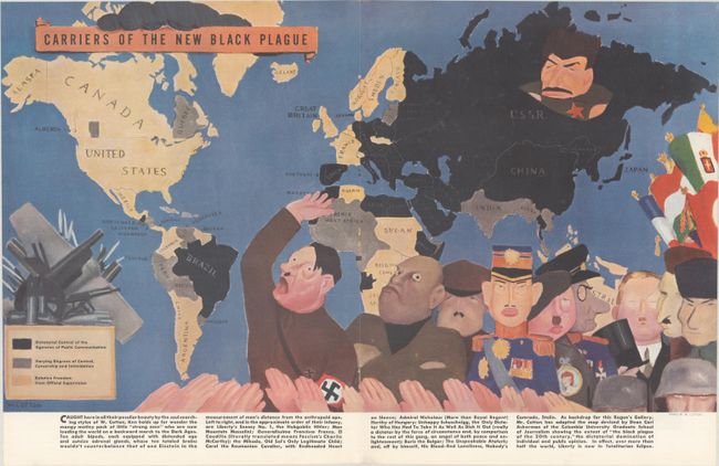
Lot 29
Subject: World
Carriers of the New Black Plague, 1938
Size: 20.7 x 11.8 inches (52.6 x 30 cm)
Estimate: $180 - $220
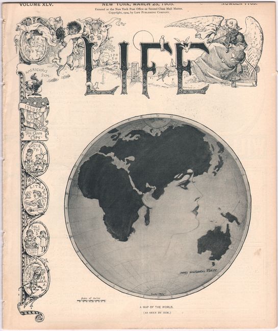
Lot 39
Subject: Cartographic Miscellany, Eastern Hemisphere
A Map of the World (As Seen by Him.), 1905
Size: 8.9 x 10.5 inches (22.6 x 26.7 cm)
Estimate: $140 - $170
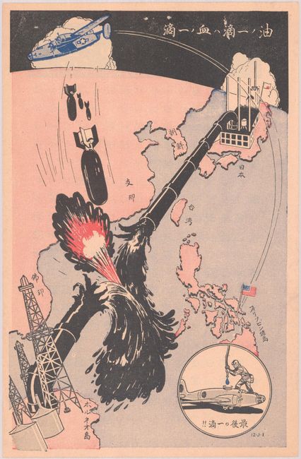
Lot 44
Subject: Cartographic Miscellany, Southeast Asia, World War II
U.S. Army
[U.S. Army Propaganda Leaflet in Japanese - Pipe Line], 1944
Size: 5.3 x 8.2 inches (13.5 x 20.8 cm)
Estimate: $200 - $230
Produced by the Psychological Warfare Branch
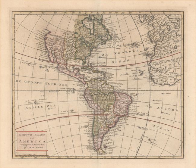
Lot 58
Subject: Western Hemisphere - America
Tirion, Isaac
Nieuwe Kaart van America, 1769
Size: 12.6 x 10.9 inches (32 x 27.7 cm)
Estimate: $275 - $350
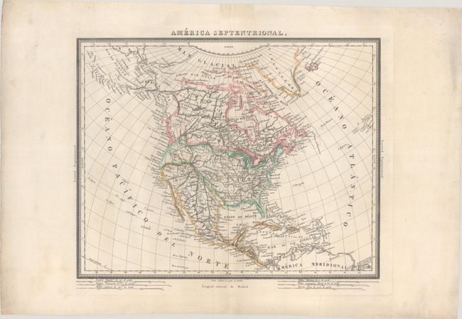
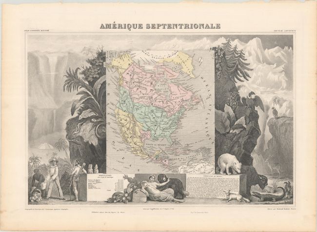
Lot 71
Subject: North America
Alabern, Pablo
America Septentrional, 1830
Size: 16.5 x 13.2 inches (41.9 x 33.5 cm)
Estimate: $160 - $190
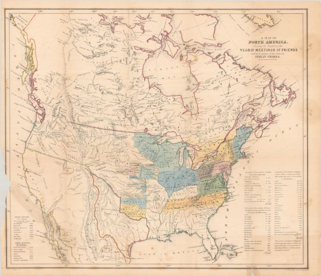
Lot 75
Subject: North America, Texas
Religious Society of Friends
[2 Maps in Report] A Map of North America, Denoting the Boundaries of the Yearly Meetings of Friends and the Locations of the Various Indian Tribes [and] Aboriginal America, East of the Mississippi, 1844
Size: 6 x 9 inches (15.2 x 22.9 cm)
Estimate: $240 - $300
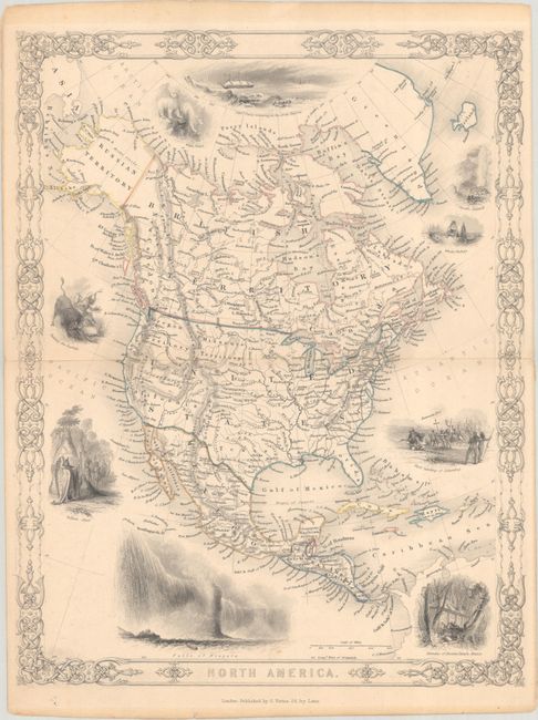
Lot 76
Subject: North America
Virtue, George
North America, 1850
Size: 9.8 x 12.6 inches (24.9 x 32 cm)
Estimate: $140 - $170
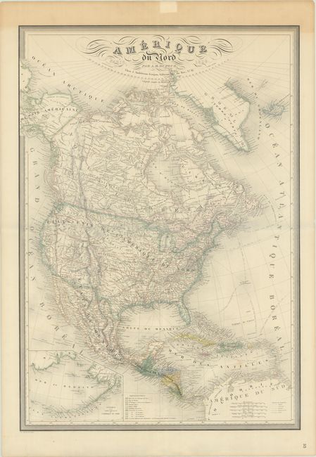
Lot 78
Subject: North America
Dufour, Auguste-Henri
Amerique du Nord, 1859
Size: 24.8 x 35.6 inches (63 x 90.4 cm)
Estimate: $275 - $350
Lot 79
Subject: North America, Texas
Levasseur, Victor
Amerique Septentrionale, 1861
Size: 17.3 x 11.2 inches (43.9 x 28.4 cm)
Estimate: $150 - $180
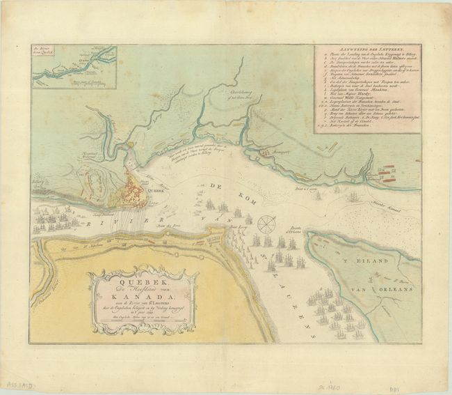
Lot 91
Subject: Quebec City & St. Lawrence River, Canada
Tirion, Isaac
Quebek, de Hoofdstad van Kanada; aan de Rivier van st. Laurens..., 1769
Size: 17 x 13 inches (43.2 x 33 cm)
Estimate: $200 - $230
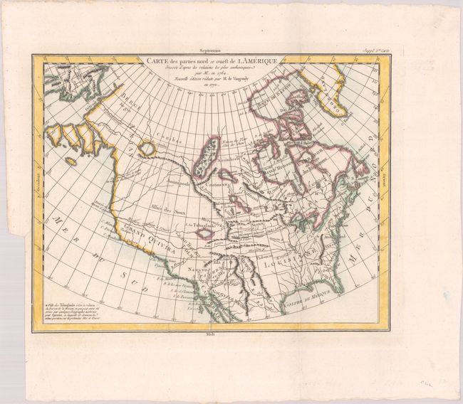
Lot 93
Subject: Colonial United States & Canada
Robert de Vaugondy, Didier
Carte des Parties Nord et Ouest de l Amerique Dressee d'Apres les Relations les Plus Authentiques par M... en 1764, 1772
Size: 15 x 11.7 inches (38.1 x 29.7 cm)
Estimate: $200 - $230
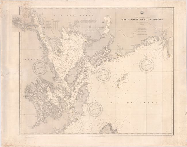
Lot 105
Subject: Passamaquoddy Bay & Bay of Fundy
U.S. Hydrographic Office
Passamaquoddy Bay and Approaches, 1891
Size: 36.6 x 28.9 inches (93 x 73.4 cm)
Estimate: $275 - $350
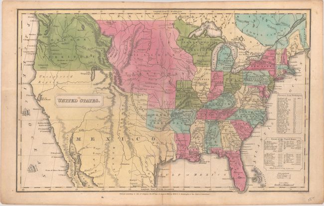
Lot 110
Subject: United States
Huntington, F. J.
United States, 1830
Size: 16 x 10.2 inches (40.6 x 25.9 cm)
Estimate: $160 - $190
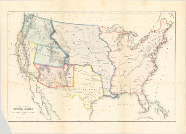
Lot 112
Subject: United States
U.S. Government
Map of the United States Exhibiting the Military Depts. & Posts, 1860
Size: 19.8 x 12.9 inches (50.3 x 32.8 cm)
Estimate: $300 - $375
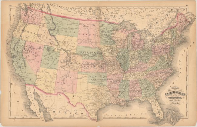
Lot 114
Subject: United States
Walling & Gray
Map of the United States and Territories, 1872
Size: 26.1 x 16.8 inches (66.3 x 42.7 cm)
Estimate: $180 - $220
Features an Orphaned "Part of Dakota"

Lot 116
Subject: United States
Donaldson, Thomas
Map of the United States Exhibiting the Grants of Lands Made by the General Government to Aid in the Construction of Railroads and Wagon Roads..., 1884
Size: 28.5 x 19.8 inches (72.4 x 50.3 cm)
Estimate: $250 - $325
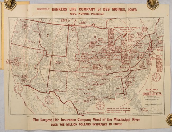
Lot 118
Subject: United States
Kenyon Company, The
Radio Map of the United States, 1925
Size: 21 x 13 inches (53.3 x 33 cm)
Estimate: $140 - $170
Lot 120
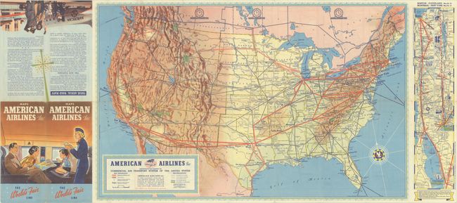
Subject: United States, Aviation
American Airlines Inc. Comprehensive Map Showing the Commercial Air Transport System of the United States, 1939
Size: 27.7 x 17.6 inches (70.4 x 44.7 cm)
Estimate: $180 - $220
A Very Early American Airlines Map

Lot 123
Subject: United States
U.S. Department of Interior
A Seafood Tour of the U.S.A. - A Cookery Compendium of Selected Seafoods for Delectable Dining, 1961
Size: 19.8 x 18.3 inches (50.3 x 46.5 cm)
Estimate: $140 - $170
Unusual Unrecorded Government Pictorial Map Promoting Seafood

Lot 124
Subject: United States
The National Rifle Association Pictorial Wildlife and Game Map of the United States, 1972
Size: 26.9 x 18.9 inches (68.3 x 48 cm)
Estimate: $240 - $300
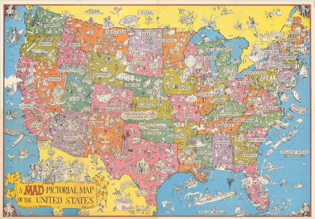
Lot 125
Subject: United States
A Mad Pictorial Map of the United States, 1981
Size: 28.9 x 20.2 inches (73.4 x 51.3 cm)
Estimate: $120 - $150
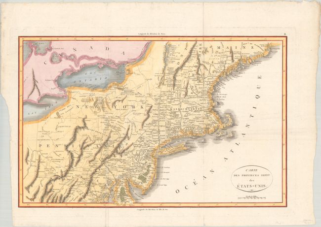
Lot 129
Subject: Eastern United States
Rochefoucald Liancourt, Francois Alexander
Carte des Provinces Septles. des Etats-Unis, 1807
Size: 19.9 x 12.8 inches (50.5 x 32.5 cm)
Estimate: $200 - $230
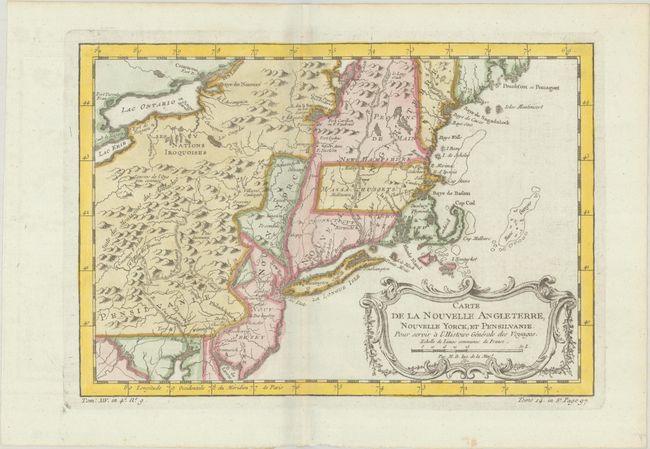
Lot 134
Subject: Colonial New England & Mid-Atlantic United States
Bellin, Jacques Nicolas
Carte de la Nouvelle Angleterre, Nouvelle Yorck, et Pensilvanie. Pour Servir a l'Histoire Generale des Voyages, 1757
Size: 11.8 x 8.1 inches (30 x 20.6 cm)
Estimate: $220 - $250
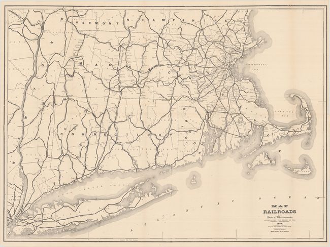
Lot 138
Subject: New England United States
Rand, Avery & Co.
Map of the Railroads of the State of Massachusetts..., 1874
Size: 38 x 28 inches (96.5 x 71.1 cm)
Estimate: $140 - $170

Lot 149
Subject: Colonial Southern United States
Bonne, Rigobert
Carte de la Louisiane, et de la Floride, 1780
Size: 8.3 x 12.7 inches (21.1 x 32.3 cm)
Estimate: $160 - $190

Lot 152
Subject: Upper Midwestern United States
Murray, John
Sources of the Mississippi, 1834
Size: 8.1 x 7.6 inches (20.6 x 19.3 cm)
Estimate: $120 - $150

Lot 156
Subject: Western United States
Gunnison, John William [Capt.]
[Lot of 4] From the Western Boundary of Missouri to the Mouth of Trap Creek [and] From the Mouth of Trap Creek to the Santa Fe Crossing [and] From the Santa Fe Crossing to the Coo-che-to-pa Pass [and] From the Coo-che-to-pa Pass to the Wahsatch Mountains, 1855
Size: 23.2 x 31.3 inches (58.9 x 79.5 cm)
Estimate: $200 - $250

Lot 158
Subject: Western United States, Oregon
Railroad Companies, (Various)
The Summerland Beautiful, 1925
Size: 8 x 15.1 inches (20.3 x 38.4 cm)
Estimate: $160 - $190

Lot 161
Subject: Northwestern United States
Johnson, A. J.
Johnson's Nebraska, Dakota, Idaho, Montana and Wyoming, 1865
Size: 23.4 x 17.1 inches (59.4 x 43.4 cm)
Estimate: $140 - $170

Lot 164
Subject: Southwestern United States
Eddy, Gerald
Panoramic Perspective of the Area Adjacent to Hoover Dam and Lake Mead Recreational Area, 1948
Size: 30.3 x 21 inches (77 x 53.3 cm)
Estimate: $140 - $170

Lot 165
Subject: Southwestern United States
Navajoland U.S.A., 1960
Size: 27.8 x 20.6 inches (70.6 x 52.3 cm)
Estimate: $160 - $190

Lot 167
Subject: Alaska
A Good-Natured Map of Alaska Showing the Services Offered by "The Alaska Line" and Suggesting Some of the Most Interesting Features of the Territory , 1934
Size: 28.4 x 21.1 inches (72.1 x 53.6 cm)
Estimate: $160 - $190

Lot 170
Subject: Southern Arizona
[Map in Book] Part of Salt River Valley Maricopa County Arizona [in] Arizona with Particular Attention to Its Imperial County of Maricopa, 1901
Size: 11.3 x 7.6 inches (28.7 x 19.3 cm)
Estimate: $200 - $250
Early Phoenix Map and Immigration Promotional Piece

Lot 174
Subject: Sacramento, California
Denny's Pocket Map of Sacramento County California Compiled from Latest Official and Private Data, 1913
Size: 24.4 x 26.6 inches (62 x 67.6 cm)
Estimate: $160 - $190

Lot 176
Subject: San Francisco, California
Bill, Henry
San Francisco, 1855
Size: 15.7 x 7.5 inches (39.9 x 19.1 cm)
Estimate: $240 - $300

Lot 177
Subject: San Francisco, California
U.S. Geological Survey (USGS)
[Map and View in Report] Map of San Francisco Showing Burned District... [and] Map of San Francisco and Vicinity Showing Relation of Burned District to the Entire City... [in] The San Francisco Earthquake and Fire of April 18, 1906..., 1907
Size: 5.8 x 9.1 inches (14.7 x 23.1 cm)
Estimate: $160 - $190
Features an Aerial Photographic View of the Burned District

Lot 180
Subject: Central California
Automobile Club of Southern California
Outing Map of East Central California Camping - Fishing - Hunting, 1925
Size: 22.8 x 36 inches (57.9 x 91.4 cm)
Estimate: $140 - $170
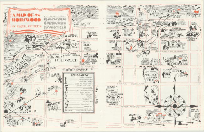
Lot 185
Subject: Hollywood, California
A Map of Hollywood, 1935
Size: 20.9 x 13.1 inches (53.1 x 33.3 cm)
Estimate: $200 - $240

Lot 191
Subject: Florida
Matthews-Northrup Co
[Map in Brochure] Florida East Coast Railway and Hotel, 1902-03
Size: 6.9 x 9.1 inches (17.5 x 23.1 cm)
Estimate: $180 - $220
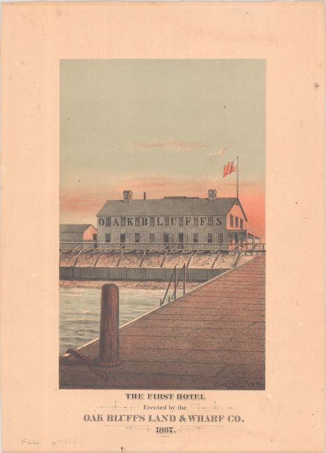
Lot 208
Subject: Martha's Vineyard, Massachusetts
The First Hotel Erected by the Oak Bluffs Land & Wharf Co. 1867, 1878
Size: 6.4 x 10.3 inches (16.3 x 26.2 cm)
Estimate: $275 - $350
Martha’s Vineyard First Hotel

Lot 209
Subject: Boston, Massachusetts
Bellin, Jacques Nicolas
Grundriss von der Stadt Boston und Ihren Gegenden, 1758
Size: 9.9 x 6.4 inches (25.1 x 16.3 cm)
Estimate: $240 - $300

Lot 219
Subject: New York
Colton, G.W. & C.B.
Colton's Railroad & Township Map of the State of New York, with Parts of the Adjoining States & Canada, 1871
Size: 28.4 x 25.2 inches (72.1 x 64 cm)
Estimate: $160 - $190

Lot 220
Subject: New York & New Jersey
[Lot of 3] Waring's Road Maps. Route No. 16 - New York to Oyster Bay [and] Route No. 5. - New York to Lake Hopatcong [and] Route No. 14. New York to Greenwood Lake , 1897
Size: 21 x 2.8 inches (53.3 x 7.1 cm)
Estimate: $180 - $220
Unrecorded Early Spalding Bicycle Road Pocket Maps

Lot 228
Subject: New York City, New York
New York, 1964
Size: 41.9 x 33 inches (106.4 x 83.8 cm)
Estimate: $275 - $350
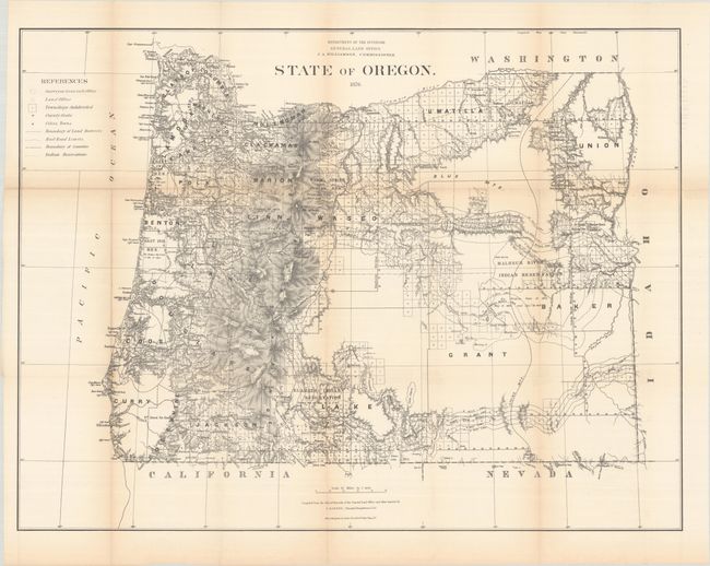
Lot 230
Subject: Oregon
General Land Office
State of Oregon, 1876
Size: 31.5 x 23.9 inches (80 x 60.7 cm)
Estimate: $180 - $220

Lot 231
Subject: Oregon
Geographical Publishing Co.
Premier Series Oregon, 1915
Size: 27.9 x 20 inches (70.9 x 50.8 cm)
Estimate: $140 - $170

Lot 232
Subject: Pennsylvania
Lucas, Fielding
Pennsylvania, 1823
Size: 18 x 11.4 inches (45.7 x 29 cm)
Estimate: $220 - $250
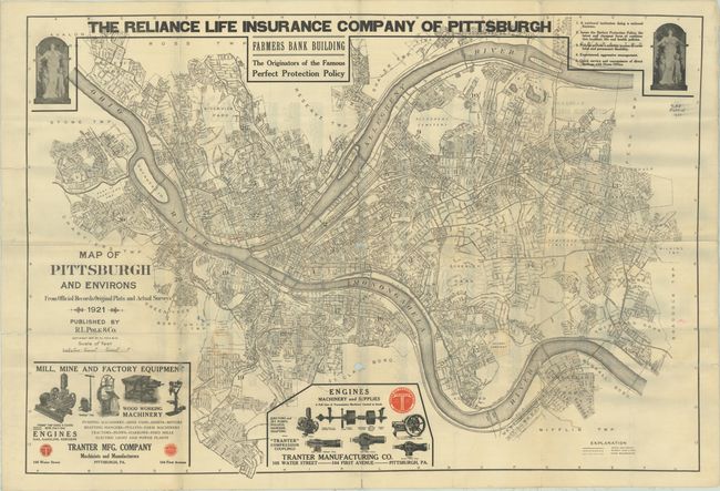
Lot 234
Subject: Pittsburgh, Pennsylvania
Map of Pittsburgh and Environs from Official Records Original Plats and Actual Surveys, 1921
Size: 40.4 x 27.8 inches (102.6 x 70.6 cm)
Estimate: $120 - $150

Lot 238
Subject: Texas
Colton, G.W. & C.B.
Colton's Texas, 1873
Size: 27.6 x 17.5 inches (70.1 x 44.5 cm)
Estimate: $275 - $350
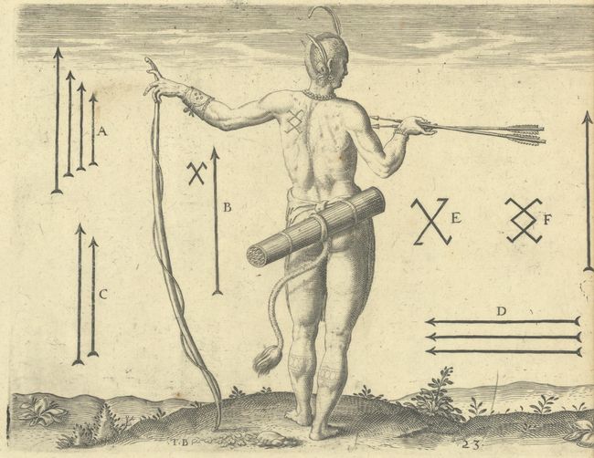
Lot 244
Subject: Virginia, Natives
Bry, Theodore de
[Lot of 2 - The Marks of the Chief Men of Virginia & How the Chief Ladies of Dasamonquepeio Carry their Children] Von Etlichen der Furnembsten Herrn in Virginia Marckzeichen [and] Wie die Weiber Dasamonquepeuc die Kinder Zutragen Pflegen, 1620
Size: 8.3 x 6.3 inches (21.1 x 16 cm)
Estimate: $240 - $300
186 lots
Page 1 of 4