Subject: Western United States
Period: 1855 (dated)
Publication: U.S. Pacific Railroad Surveys
Color: Black & White
Size:
23.2 x 31.3 inches
58.9 x 79.5 cm
During the 1850s, the U.S. government sponsored an extensive series of expeditions designed to gather information on the vast new territories that had been acquired in western North America. The discovery of gold in California further stimulated westward traffic and heightened the need for a faster and more convenient way to bring the far-flung parts of the country together. In 1853 Congress commissioned the Army's Topographic Bureau to conduct a series of surveys to find a suitable route for a transcontinental railroad. There were six major expeditions; five of them covered the area between the Great Plains and west coast, and the sixth explored the coastal states of California and Oregon. All of these expeditions were accompanied by naturalists and artists to document the landscape, flora and fauna along the route.
The reports, maps and lithographs were published in the 13 volume report "Explorations and Surveys to ascertain the most practicable and economical route for a Railroad from the Mississippi river to the Pacific Ocean."
A matched set of four maps that are seldom seen or offered together. Map No. 1 details the proposed routes across the territories of Missouri and part of Kansas. Three proposed railroad routes are shown and named. The North Missouri R.R. heads north from above Washington on the Missouri River. The Pacific R.R. follows the Missouri R. to Jefferson City then on to Independence where it reconnects with the Missouri and then moves upstream along the Kansas River. The South West Branch heads southwest to Springfield and beyond.
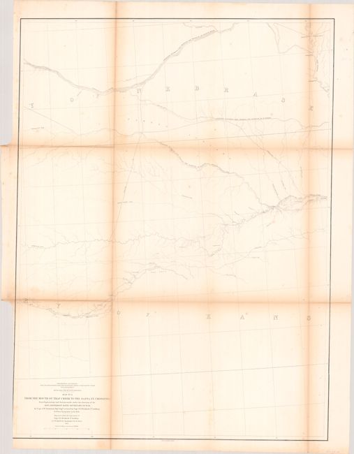
Map No. 2 details the proposed routes across the territories of Kansas and Nebraska. One left the Missouri River at Kansas and followed the Pawnee Republican Fork, another left the Missouri River at St. Joseph and went westward to the Republican River, and the final proposed route left the Missouri River at Council Bluffs and headed west along the Platte River.
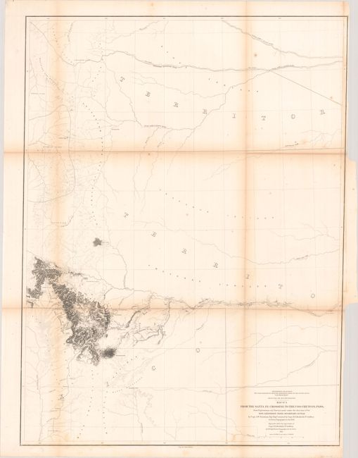
The third map in this series shows the proposed routes across parts of New Mexico and today's Colorado. Details along the route surveyed include watershed and topographical via fine hachure. Locates North, Middle and South Parks, Cheyenne Pass, Saint Vrain's Fort, Pikes Peak and more.
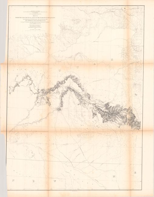
Gunnison's final and most detailed map of the series Wheat illustrated in full. While there is minimal detail in the north and south, the map provides much detail along the route through western Colorado and Utah. Locates Fort Uintah, Brown's Hole, the Old Spanish Trail, and Bridger's Pass. An interesting and important map of the region that would eventually be followed by the Denver and Rio Grande Railroad. Capt. Gunnison was killed by hostile Indians at the western portion of this exploration, but Capt. E.G. Beckwith recovered his survey notes and completed the map.
References: Wheat (TMW) #843-846.
Condition: B
Issued folding with light toning along the fold lines and minor foxing. There are binding trims at bottom left or right which have been trimmed to just inside the border on three of the sheets.