Showing Unsold Lots(remove filter)
Filtered by Category:United States(Show All Categories)
Current Auction
48 lots
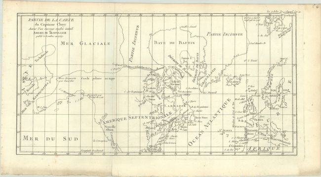
Lot 94
Subject: Colonial United States & Canada, Arctic
Robert de Vaugondy, Didier
Partie de la Carte du Capitaine Cluny Auteur d'un Ouvrage Anglois Intitule American Traveller Publie a Londres en 1769, 1773
Size: 16.4 x 8.6 inches (41.7 x 21.8 cm)
Estimate: $110 - $140
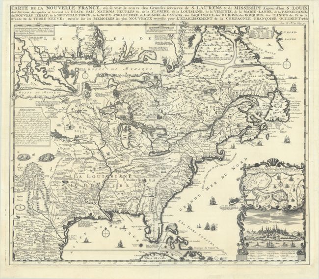
Lot 95
Subject: Colonial Eastern United States & Canada
Chatelain, Henry Abraham
Carte de la Nouvelle France, ou se Voit le Cours des Grandes Rivieres de S. Laurens & de Mississipi Aujour d'hui S. Louis, aux Environs des-quelles se Trouvent les Etats, Pais, Nations, Peuples, &c. de la Floride, de la Louisiane, de la Virginie..., 1719
Size: 19.3 x 16.7 inches (49 x 42.4 cm)
Estimate: $2,200 - $2,500
One of the Most Informative 18th Century Maps of the French Possessions in North America
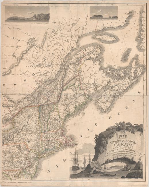
Lot 104
Subject: Northeastern United States & Canada
Bouchette, Joseph
[Eastern Sheet] Map of the Provinces of Upper & Lower Canada with the Adjacent Parts of the United States of America &c. Compiled from the Latest Surveys and Adjusted from the Most Recent and Approved Astronomical Observations, 1815
Size: 24.3 x 30 inches (61.7 x 76.2 cm)
Estimate: $2,400 - $3,000
Eastern Sheet of Bouchette's Rare Map Presenting Lower Canada and New England
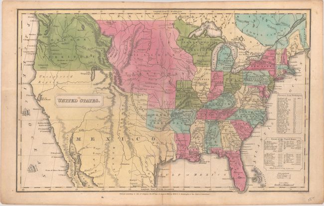
Lot 110
Subject: United States
Huntington, F. J.
United States, 1830
Size: 16 x 10.2 inches (40.6 x 25.9 cm)
Estimate: $160 - $190
Lot 112
Subject: United States
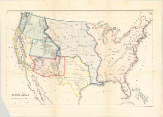
U.S. Government
Map of the United States Exhibiting the Military Depts. & Posts, 1860
Size: 19.8 x 12.9 inches (50.3 x 32.8 cm)
Estimate: $300 - $375
Lot 113
Subject: United States
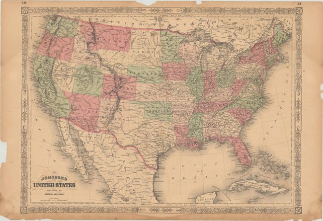
Johnson and Ward
Johnson's United States, 1864
Size: 23.3 x 17.1 inches (59.2 x 43.4 cm)
Estimate: $90 - $120
Lot 120
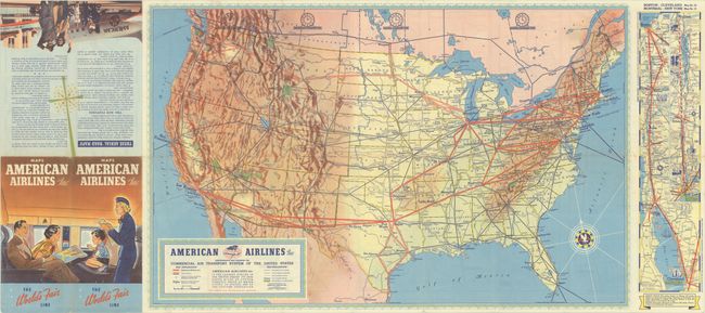
Subject: United States, Aviation
American Airlines Inc. Comprehensive Map Showing the Commercial Air Transport System of the United States, 1939
Size: 27.7 x 17.6 inches (70.4 x 44.7 cm)
Estimate: $180 - $220
A Very Early American Airlines Map
Lot 122
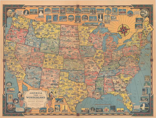
Subject: United States
Dudley Chase, Ernest
America the Wonderland - A Pictorial Map of the United States, 1954
Size: 27.9 x 20.6 inches (70.9 x 52.3 cm)
Estimate: $300 - $375

Lot 124
Subject: United States
The National Rifle Association Pictorial Wildlife and Game Map of the United States, 1972
Size: 26.9 x 18.9 inches (68.3 x 48 cm)
Estimate: $240 - $300
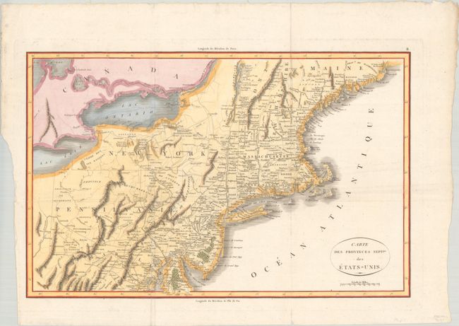
Lot 129
Subject: Eastern United States
Rochefoucald Liancourt, Francois Alexander
Carte des Provinces Septles. des Etats-Unis, 1807
Size: 19.9 x 12.8 inches (50.5 x 32.5 cm)
Estimate: $200 - $230
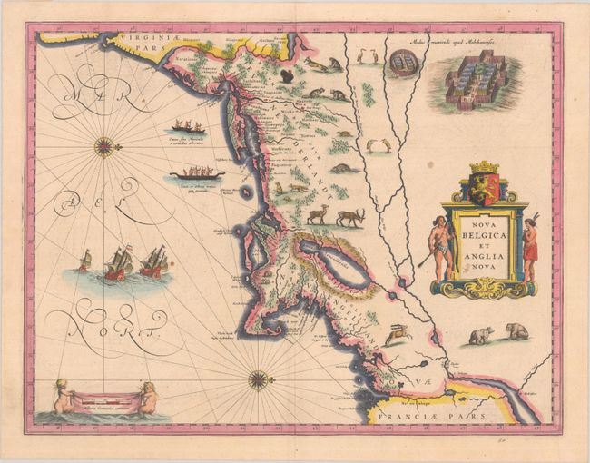
Lot 132
Subject: Colonial New England & Mid-Atlantic United States
Blaeu, (Family)
Nova Belgica et Anglia Nova, 1638
Size: 19.9 x 15.3 inches (50.5 x 38.9 cm)
Estimate: $1,600 - $1,900
Important Map of Colonial New England and the Mid-Atlantic
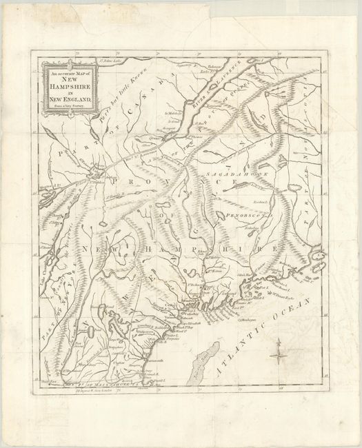
Lot 136
Subject: Colonial New England United States
Anon.
An Accurate Map of New Hampshire in New England, from a Late Survey, 1781
Size: 11.1 x 12.7 inches (28.2 x 32.3 cm)
Estimate: $325 - $400
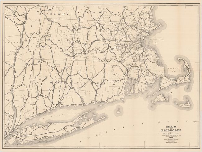
Lot 138
Subject: New England United States
Rand, Avery & Co.
Map of the Railroads of the State of Massachusetts..., 1874
Size: 38 x 28 inches (96.5 x 71.1 cm)
Estimate: $140 - $170
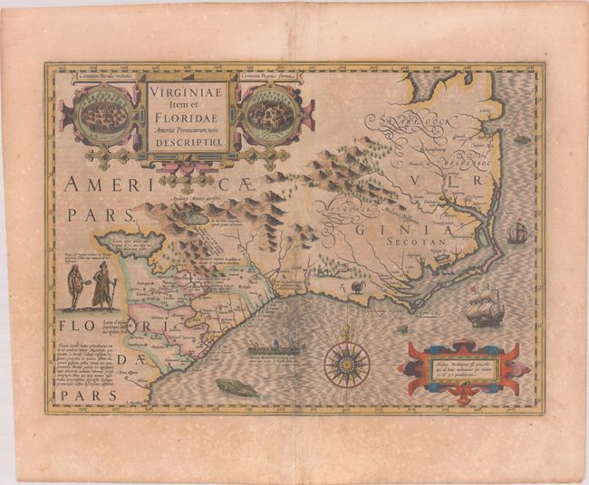
Lot 141
Subject: Colonial Southeastern United States
Hondius, Jodocus
Virginiae Item et Floridae Americae Provinciarum, Nova Descriptio, 1619
Size: 19.1 x 13.5 inches (48.5 x 34.3 cm)
Estimate: $1,400 - $1,700
A Seminal Map of the Southeast and Early American Cartography in Full Contemporary Color
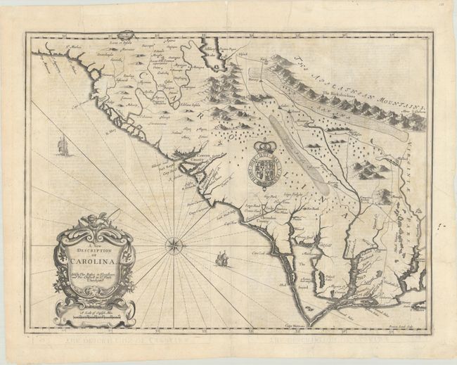
Lot 143
Subject: Colonial Southeastern United States
Speed/Lamb
A New Description of Carolina, 1676
Size: 19.8 x 14.8 inches (50.3 x 37.6 cm)
Estimate: $1,800 - $2,100
Speed's Map of the Carolinas Based Upon the Lords Proprietor's Map
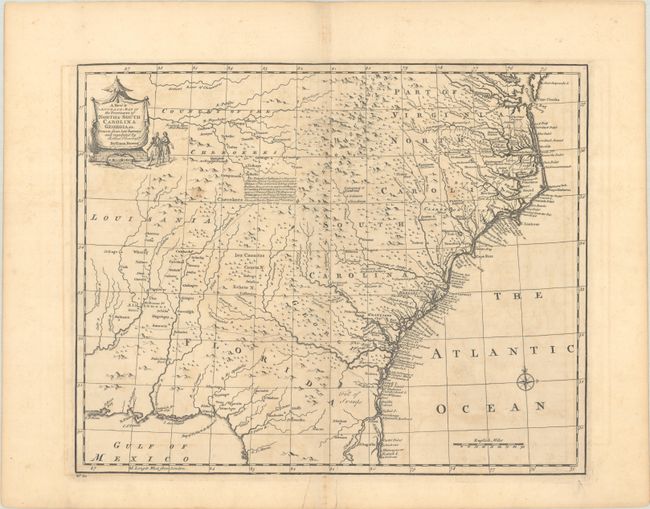
Lot 144
Subject: Colonial Southeastern United States
Bowen, Emanuel
A New & Accurate Map of the Provinces of North & South Carolina Georgia &c. Drawn from Late Surveys and Regulated by Astronl. Observatns., 1747
Size: 17 x 13.7 inches (43.2 x 34.8 cm)
Estimate: $700 - $850
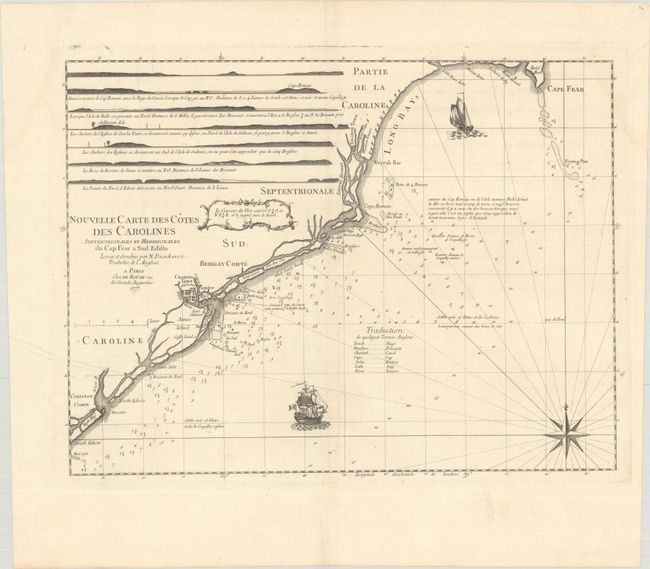
Lot 146
Subject: Colonial Southeastern United States
Le Rouge, George Louis
Nouvelle Carte des Cotes des Carolines Septentrionales et Meridionales du Cap Fear a Sud Edisto..., 1777
Size: 21.3 x 16.1 inches (54.1 x 40.9 cm)
Estimate: $1,000 - $1,300
Rare French Chart of the Carolina Coast
Lot 148
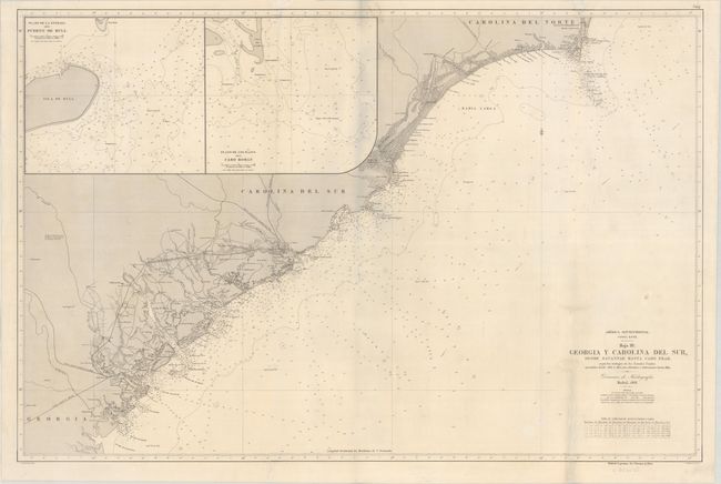
Subject: Carolinas & Georgia Coast
Direccion de Hidrografia
America Septentrional. Costa Este. Hoja III. Georgia y Carolina del Sur, Desde Savannah Hasta Cabo Fear... , 1868
Size: 36.4 x 23.9 inches (92.5 x 60.7 cm)
Estimate: $700 - $850
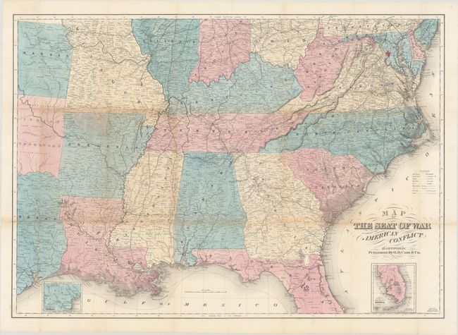
Lot 151
Subject: Southern United States, Civil War
Case & Company
Map of the Seat of War to Accompany the American Conflict, 1866
Size: 36.8 x 25.9 inches (93.5 x 65.8 cm)
Estimate: $325 - $400

Lot 152
Subject: Upper Midwestern United States
Murray, John
Sources of the Mississippi, 1834
Size: 8.1 x 7.6 inches (20.6 x 19.3 cm)
Estimate: $120 - $150

Lot 156
Subject: Western United States
Gunnison, John William [Capt.]
[Lot of 4] From the Western Boundary of Missouri to the Mouth of Trap Creek [and] From the Mouth of Trap Creek to the Santa Fe Crossing [and] From the Santa Fe Crossing to the Coo-che-to-pa Pass [and] From the Coo-che-to-pa Pass to the Wahsatch Mountains, 1855
Size: 23.2 x 31.3 inches (58.9 x 79.5 cm)
Estimate: $200 - $250
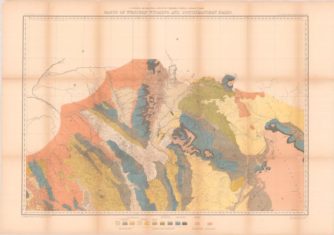
Lot 160
Subject: Wyoming & Idaho
Hayden, Ferdinand Vandeveer
Parts of Western Wyoming and Southeastern Idaho, 1883
Size: 32.8 x 22.8 inches (83.3 x 57.9 cm)
Estimate: $100 - $130
Locates Jackson Hole and the Tetons

Lot 165
Subject: Southwestern United States
Navajoland U.S.A., 1960
Size: 27.8 x 20.6 inches (70.6 x 52.3 cm)
Estimate: $160 - $190

Lot 167
Subject: Alaska
A Good-Natured Map of Alaska Showing the Services Offered by "The Alaska Line" and Suggesting Some of the Most Interesting Features of the Territory , 1934
Size: 28.4 x 21.1 inches (72.1 x 53.6 cm)
Estimate: $160 - $190

Lot 170
Subject: Southern Arizona
[Map in Book] Part of Salt River Valley Maricopa County Arizona [in] Arizona with Particular Attention to Its Imperial County of Maricopa, 1901
Size: 11.3 x 7.6 inches (28.7 x 19.3 cm)
Estimate: $200 - $250
Early Phoenix Map and Immigration Promotional Piece
Lot 171
Subject: California
Williamson, R. S. (Lt.)
General Map of Explorations and Surveys in California Made Under the Direction of the Hon. Jefferson Davis Secretary of War..., 1853
Size: 72.4 x 24.4 inches (183.9 x 62 cm)
Estimate: $350 - $425

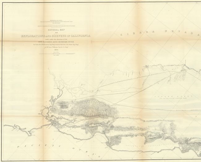
Lot 174
Subject: Sacramento, California
Denny's Pocket Map of Sacramento County California Compiled from Latest Official and Private Data, 1913
Size: 24.4 x 26.6 inches (62 x 67.6 cm)
Estimate: $160 - $190

Lot 176
Subject: San Francisco, California
Bill, Henry
San Francisco, 1855
Size: 15.7 x 7.5 inches (39.9 x 19.1 cm)
Estimate: $240 - $300

Lot 180
Subject: Central California
Automobile Club of Southern California
Outing Map of East Central California Camping - Fishing - Hunting, 1925
Size: 22.8 x 36 inches (57.9 x 91.4 cm)
Estimate: $140 - $170

Lot 191
Subject: Florida
Matthews-Northrup Co
[Map in Brochure] Florida East Coast Railway and Hotel, 1902-03
Size: 6.9 x 9.1 inches (17.5 x 23.1 cm)
Estimate: $180 - $220
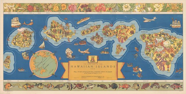
Lot 197
Subject: Hawaii
The Dole Map of the Hawaiian Islands U.S.A. Being a Descriptive Portrayal of the History, Transportation, Industries and Geography of the Territory of Hawaii, U.S.A., 1937
Size: 35.6 x 17.4 inches (90.4 x 44.2 cm)
Estimate: $500 - $650
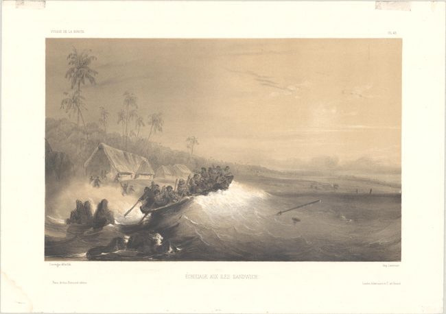
Lot 200
Subject: Hawaii
Lemercier
Echouage aux Iles Sandwich, 1845
Size: 12.4 x 7.8 inches (31.5 x 19.8 cm)
Estimate: $350 - $425
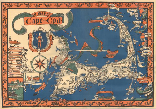
Lot 207
Subject: Cape Cod, Massachusetts
A Map of Cape Cod, 1926
Size: 34.5 x 24 inches (87.6 x 61 cm)
Estimate: $650 - $800
Vivid Pictorial Map by Female Bay Stater Artist
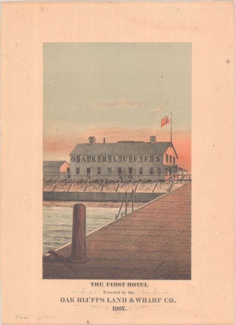
Lot 208
Subject: Martha's Vineyard, Massachusetts
The First Hotel Erected by the Oak Bluffs Land & Wharf Co. 1867, 1878
Size: 6.4 x 10.3 inches (16.3 x 26.2 cm)
Estimate: $275 - $350
Martha’s Vineyard First Hotel

Lot 209
Subject: Boston, Massachusetts
Bellin, Jacques Nicolas
Grundriss von der Stadt Boston und Ihren Gegenden, 1758
Size: 9.9 x 6.4 inches (25.1 x 16.3 cm)
Estimate: $240 - $300

Lot 219
Subject: New York
Colton, G.W. & C.B.
Colton's Railroad & Township Map of the State of New York, with Parts of the Adjoining States & Canada, 1871
Size: 28.4 x 25.2 inches (72.1 x 64 cm)
Estimate: $160 - $190

Lot 220
Subject: New York & New Jersey
[Lot of 3] Waring's Road Maps. Route No. 16 - New York to Oyster Bay [and] Route No. 5. - New York to Lake Hopatcong [and] Route No. 14. New York to Greenwood Lake , 1897
Size: 21 x 2.8 inches (53.3 x 7.1 cm)
Estimate: $180 - $220
Unrecorded Early Spalding Bicycle Road Pocket Maps
Lot 223
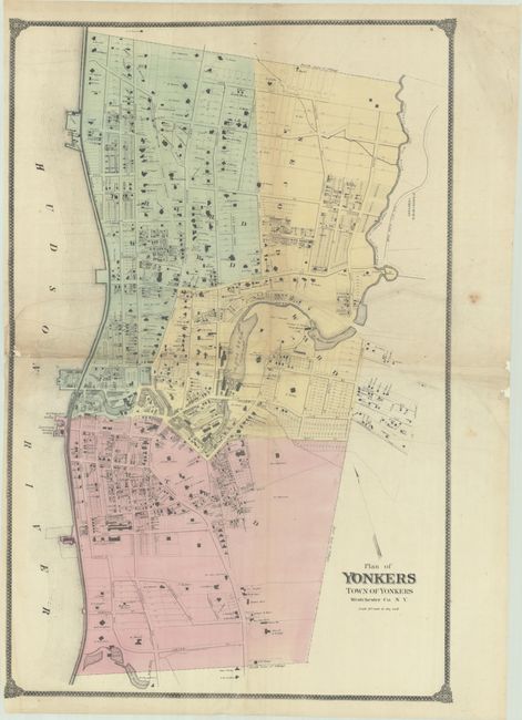
Subject: Yonkers, New York
Beers, Ellis & Soule
Plan of Yonkers Town of Yonkers Westchester Co. N.Y., 1867
Size: 21.1 x 32.1 inches (53.6 x 81.5 cm)
Estimate: $100 - $130

Lot 228
Subject: New York City, New York
New York, 1964
Size: 41.9 x 33 inches (106.4 x 83.8 cm)
Estimate: $275 - $350
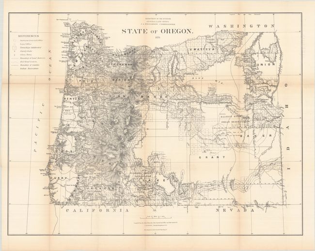
Lot 230
Subject: Oregon
General Land Office
State of Oregon, 1876
Size: 31.5 x 23.9 inches (80 x 60.7 cm)
Estimate: $180 - $220

Lot 231
Subject: Oregon
Geographical Publishing Co.
Premier Series Oregon, 1915
Size: 27.9 x 20 inches (70.9 x 50.8 cm)
Estimate: $140 - $170
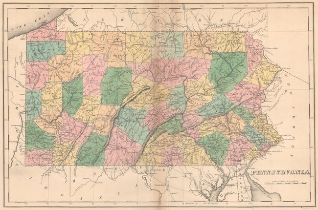
Lot 233
Subject: Pennsylvania
Carey & Lea
Geographical, Statistical, and Historical Map of Pennsylvania, 1827
Size: 17.9 x 11.8 inches (45.5 x 30 cm)
Estimate: $110 - $140
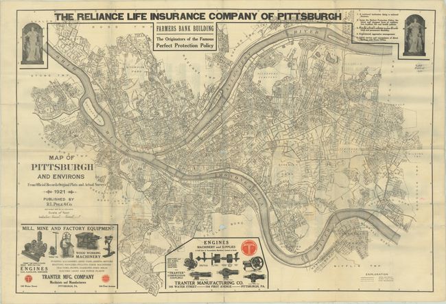
Lot 234
Subject: Pittsburgh, Pennsylvania
Map of Pittsburgh and Environs from Official Records Original Plats and Actual Surveys, 1921
Size: 40.4 x 27.8 inches (102.6 x 70.6 cm)
Estimate: $120 - $150

Lot 238
Subject: Texas
Colton, G.W. & C.B.
Colton's Texas, 1873
Size: 27.6 x 17.5 inches (70.1 x 44.5 cm)
Estimate: $275 - $350
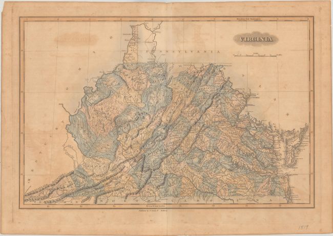
Lot 243
Subject: Virginia & West Virginia
Lucas, Fielding
Virginia, 1823
Size: 19 x 12.4 inches (48.3 x 31.5 cm)
Estimate: $375 - $450
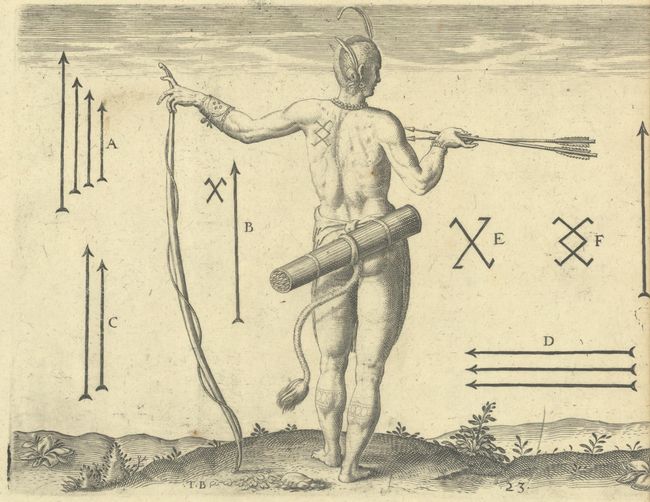
Lot 244
Subject: Virginia, Natives
Bry, Theodore de
[Lot of 2 - The Marks of the Chief Men of Virginia & How the Chief Ladies of Dasamonquepeio Carry their Children] Von Etlichen der Furnembsten Herrn in Virginia Marckzeichen [and] Wie die Weiber Dasamonquepeuc die Kinder Zutragen Pflegen, 1620
Size: 8.3 x 6.3 inches (21.1 x 16 cm)
Estimate: $240 - $300
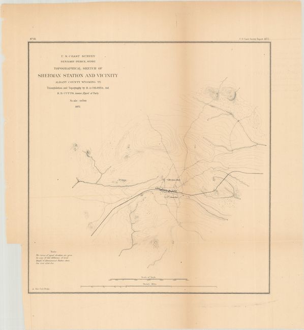
Lot 249
Subject: Southern Wyoming
U.S. Coast Survey
Topographical Sketch of Sherman Station and Vicinity Albany County Wyoming Ty., 1872
Size: 11.3 x 11.8 inches (28.7 x 30 cm)
Estimate: $100 - $130
It's Not a Coast, But It Is a Survey
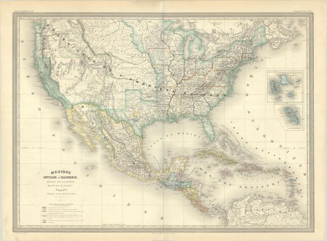
Lot 253
Subject: United States, Mexico & Central America
Dufour, Auguste-Henri
Mexique Antilles et Californie, 1860
Size: 29.6 x 21.5 inches (75.2 x 54.6 cm)
Estimate: $300 - $375
48 lots