Filtered by Category:United States(Show All Categories)
Showing results for:Auction 172
Catalog Archive
198 lots
Page 1 of 4
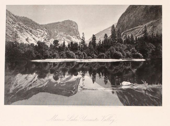
Auction 172, Lot 94
Subject: United States & Canada
Bryant, William C.
[2 Volumes] Picturesque America; or, The Land We Live In..., 1872-74
Size: 10.3 x 13 inches (26.2 x 33 cm)
Estimate: $400 - $475
Sold for: $500
Closed on 4/17/2019
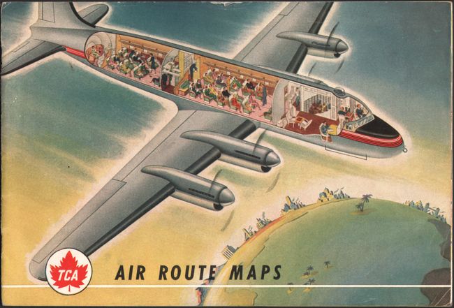
Auction 172, Lot 95
Subject: United States & Canada, Flight Maps
[Lot of 3] TCA Air Route Maps [and] Trans-Canada Air Lines Air Canada [and] Route Map Vancouver to Amsterdam, 1950-60
Size: See Description
Estimate: $100 - $130
Unsold
Closed on 4/17/2019
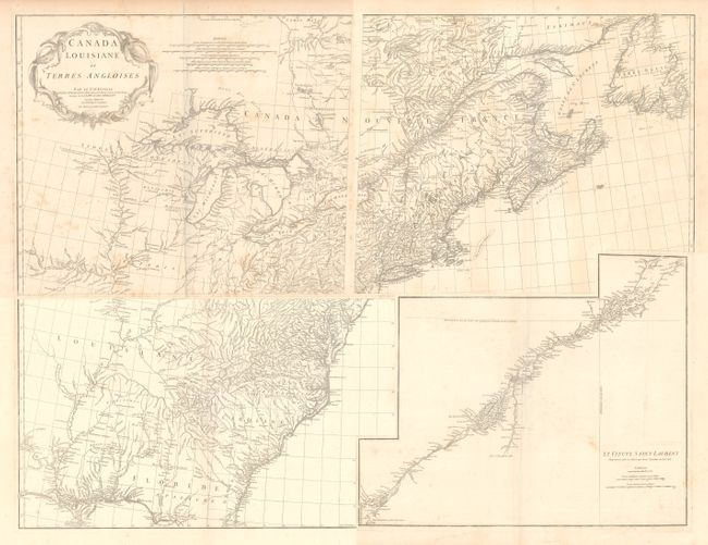
Auction 172, Lot 96
Subject: Colonial Eastern United States & Canada
Anville, Jean Baptiste Bourguignon d'
[On 4 Sheets] Canada Louisiane et Terres Angloises, 1755
Size: 22 x 18.8 inches (55.9 x 47.8 cm)
Estimate: $1,400 - $1,700
D'Anville's Spectacular Map of Eastern Seaboard
Unsold
Closed on 4/17/2019
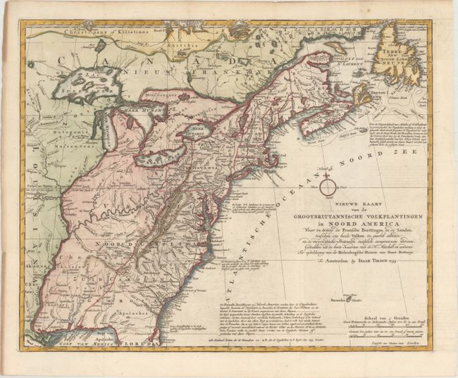
Auction 172, Lot 97
Subject: Colonial Eastern United States & Canada
Tirion, Isaac
Nieuwe Kaart van de Grootbrittannische Volkplantingen in Noord America..., 1755
Size: 17.8 x 14.4 inches (45.2 x 36.6 cm)
Estimate: $600 - $750
Sold for: $400
Closed on 4/17/2019
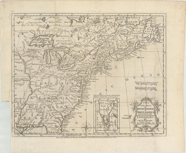
Auction 172, Lot 98
Subject: Colonial Eastern United States & Canada
Kitchin, Thomas
A New Map of the British Dominions in North America; with the Limits of the Governments Annexed Thereto by the Late Treaty of Peace, and Settled by Proclamation, October 7th, 1763, 1763
Size: 12 x 9.6 inches (30.5 x 24.4 cm)
Estimate: $400 - $475
Sold for: $375
Closed on 4/17/2019
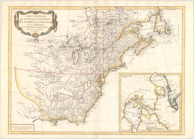
Auction 172, Lot 99
Subject: Colonial Eastern United States & Canada
D'Anville/Santini
Carte Generale du Canada, de la Louisiane, de la Floride, de la Caroline, de la Virginie, de la Nouvelle Angleterre Etc., 1776
Size: 26.1 x 18.9 inches (66.3 x 48 cm)
Estimate: $600 - $750
Sold for: $225
Closed on 4/17/2019
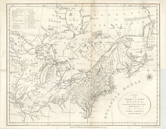
Auction 172, Lot 100
Subject: Eastern United States & Canada
Stockdale, John
A Map of the Northern and Middle States; Comprehending the Western Territory and the British Dominions in North America from the Best Authorities, 1792
Size: 15.5 x 12.4 inches (39.4 x 31.5 cm)
Estimate: $325 - $400
Sold for: $240
Closed on 4/17/2019
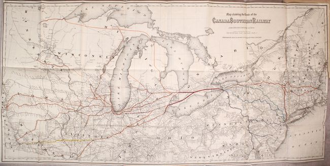
Auction 172, Lot 101
Subject: Eastern United States & Canada
Colton, G.W. & C.B.
Map Showing the Route of the Canada Southern Railway and Its Connecting Lines [bound in] The Canada Southern Railway Company. Prospectus, Reports and Other Documents, 1872
Size: 38.5 x 18.4 inches (97.8 x 46.7 cm)
Estimate: $200 - $250
Sold for: $150
Closed on 4/17/2019
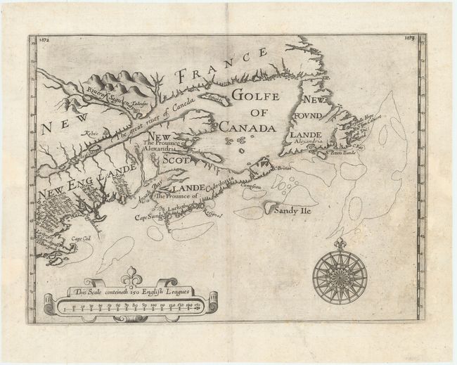
Auction 172, Lot 102
Subject: Colonial Northeastern United States & Canada
Alexander, William (Sir)
[Untitled - Northeastern United States & Canada], 1625
Size: 13.5 x 9.8 inches (34.3 x 24.9 cm)
Estimate: $6,000 - $7,500
The First Map to Name New Scotland
Unsold
Closed on 4/17/2019
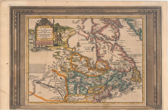
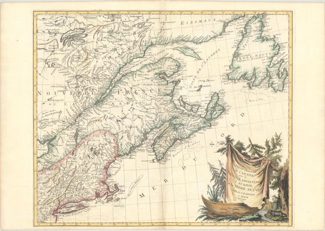
Auction 172, Lot 103
Subject: Colonial Northeastern United States & Canada
Aa, Pieter van der
Canada ou Nouvelle France, Suivant les Nouvelles Observations de Messrs. de l'Academie Royale des Sciences, Etc. Augmentees de Nouveau, 1730
Size: 15.1 x 10.3 inches (38.4 x 26.2 cm)
Estimate: $550 - $700
Unusual Picture-Frame Style Border
Sold for: $275
Closed on 4/17/2019
Auction 172, Lot 104
Subject: Colonial Northeastern United States & Canada, Great Lakes
Robert de Vaugondy, Didier
Partie de l'Amerique Septent? qui Comprend la Nouvelle France ou le Canada, 1755
Size: 23.9 x 19 inches (60.7 x 48.3 cm)
Estimate: $550 - $700
Sold for: $300
Closed on 4/17/2019
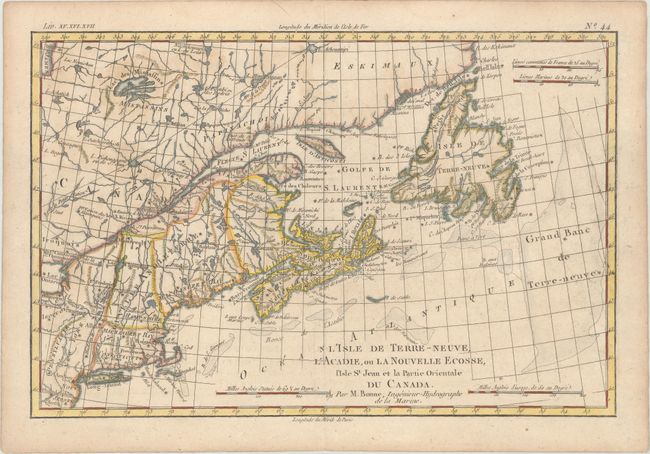
Auction 172, Lot 105
Subject: Colonial Northeastern United States & Canada
Bonne, Rigobert
L'Isle de Terre-Neuve, l'Acadie, ou la Nouvelle Ecosse, l'Isle St Jean et la Partie Orientale du Canada, 1775
Size: 12.7 x 8.4 inches (32.3 x 21.3 cm)
Estimate: $140 - $170
Unsold
Closed on 4/17/2019
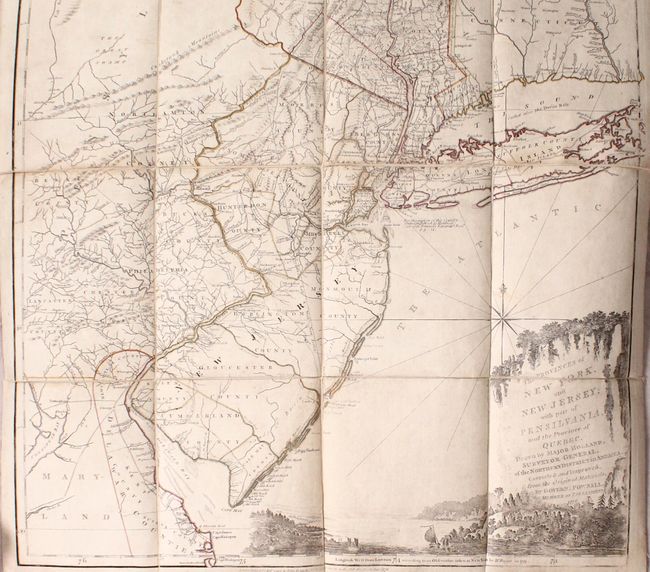
Auction 172, Lot 106
Subject: Colonial Northeastern United States & Quebec
Holland/Pownal
The Provinces of New York, and New Jersey; with Part of Pensilvania, and the Province of Quebec..., 1776
Size: 21.5 x 53.3 inches (54.6 x 135.4 cm)
Estimate: $5,000 - $6,500
Thomas Jefferys' Important Revolutionary War Period Map
Unsold
Closed on 4/17/2019
Auction 172, Lot 107
Subject: Colonial Northeastern United States & Canada
D'Anville/Santini
Partie Orientale du Canada, avec la Nouvelle Angleterre, l'Acadie, et la Terre-Neuve, 1776
Size: 22.9 x 19.1 inches (58.2 x 48.5 cm)
Estimate: $450 - $550
Sold for: $300
Closed on 4/17/2019
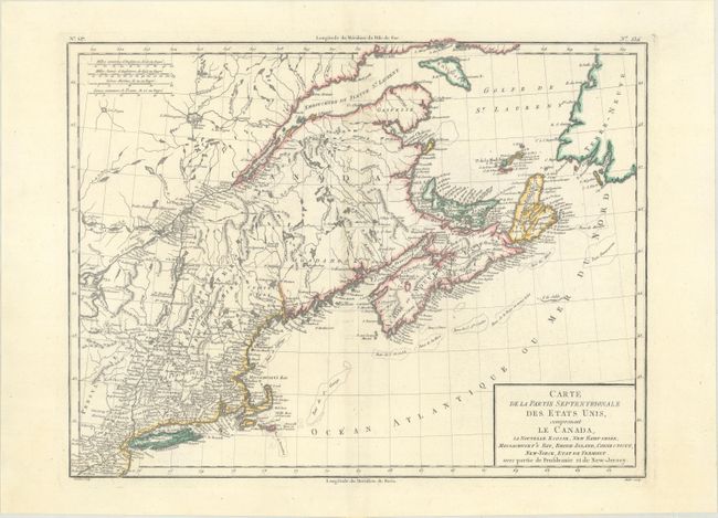
Auction 172, Lot 108
Subject: Northeastern United States & Canada
Tardieu, Pierre Francois
Carte de la Partie Septentrionale des Etats Unis, Comprenant le Canada, la Nouvelle Ecosse, New Hampshire, Massachuset's Bay, Rhode-Island, Connecticut, New-Yorck, Etat de Vermont..., 1797
Size: 16.6 x 12.7 inches (42.2 x 32.3 cm)
Estimate: $190 - $220
Sold for: $100
Closed on 4/17/2019
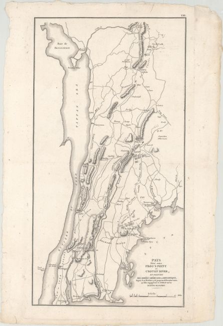
Auction 172, Lot 109
Subject: Northeastern United States & Eastern Canada
Marshall, John
[Lot of 2] Pays Situe Entre Frog's Point et Croton River, et Position des Armees Americaine et Britannique, Depuis le 12 Octobre 1776... [and] Theatre des Operations de l'Armee du Nord, et Desert que le General Arnold Traversa en Marchant Contre Quebec, 1807
Size: See Description
Estimate: $180 - $220
Unsold
Closed on 4/17/2019
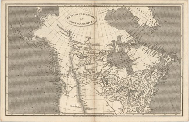
Auction 172, Lot 110
Subject: Northern United States & Canada
Arrowsmith, Aaron, Sr.
British Possessions in North America, 1809
Size: 15.4 x 9.7 inches (39.1 x 24.6 cm)
Estimate: $160 - $190
Sold for: $140
Closed on 4/17/2019
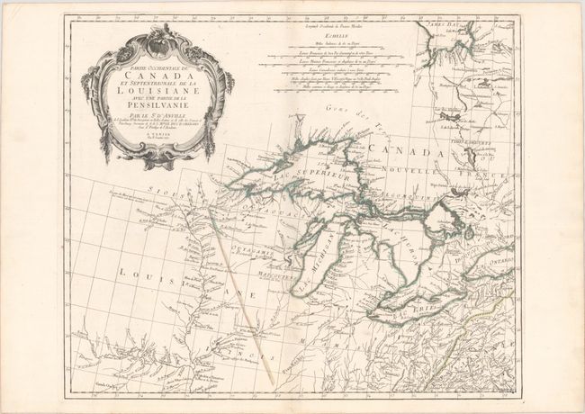
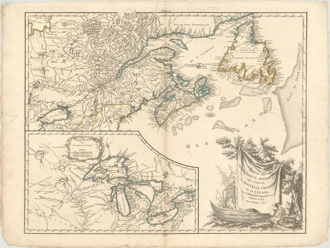
Auction 172, Lot 111
Subject: Colonial Central United States & Canada, Great Lakes
D'Anville/Santini
Partie Occidentale du Canada et Septentrionale de la Louisiane avec une Partie de la Pensilvanie, 1775
Size: 22.6 x 19 inches (57.4 x 48.3 cm)
Estimate: $900 - $1,100
Sold for: $650
Closed on 4/17/2019
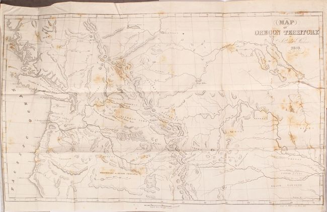
Auction 172, Lot 112
Subject: Western United States & Canada
Parker, Samuel (Rev.)
Map of Oregon Territory [bound in] Journal of an Exploring Tour Beyond the Rocky Mountains…, 1844
Size: 23 x 13.6 inches (58.4 x 34.5 cm)
Estimate: $475 - $600
Sold for: $350
Closed on 4/17/2019
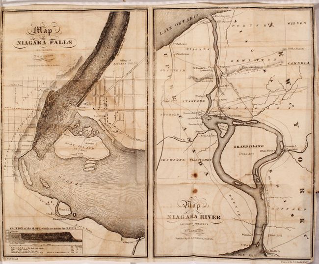
Auction 172, Lot 113
Subject: Niagara Falls, New York, Canada
[Lot of 2] A Guide to Travelers Visiting the Falls of Niagara... [and] The Travellers' Own Book, to Saratoga Springs, Niagara Falls and Canada..., 1835-41
Size: 3.8 x 5.9 inches (9.7 x 15 cm)
Estimate: $180 - $220
Sold for: $120
Closed on 4/17/2019
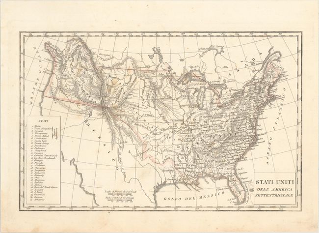
Auction 172, Lot 114
Subject: United States
[Lot of 3] Stati Uniti dell' America Settentrionale [and] Stati-Uniti [and] United States, 1845-61
Size: See Description
Estimate: $250 - $325
Sold for: $180
Closed on 4/17/2019

Auction 172, Lot 115
Subject: United States, Immigration
General Land Office
Map of the United States of America [bound in] Brief Description of the Public Lands of the United States of America, 1873
Size: 26.6 x 16.3 inches (67.6 x 41.4 cm)
Estimate: $150 - $180
A Map for the European Immigrant
Sold for: $110
Closed on 4/17/2019
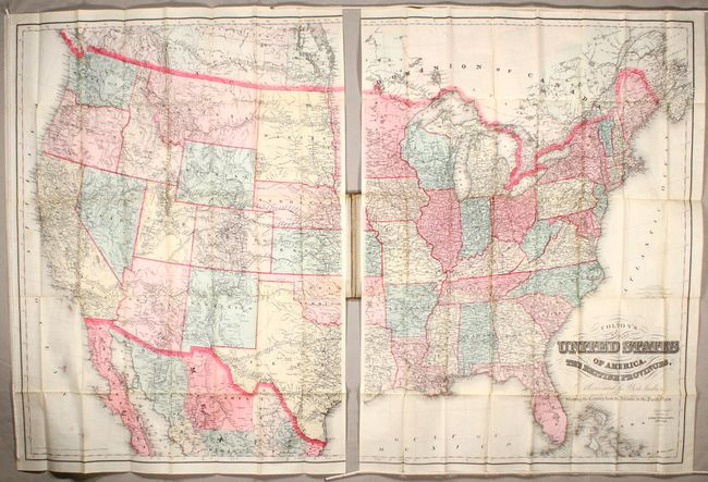
Auction 172, Lot 116
Subject: United States
Colton, G.W. & C.B.
Colton's Map of the United States of America, the British Provinces, Mexico and the West Indies. Showing the Country from the Atlantic to the Pacific Ocean, 1884
Size: 51.6 x 33.6 inches (131.1 x 85.3 cm)
Estimate: $475 - $600
Sold for: $350
Closed on 4/17/2019
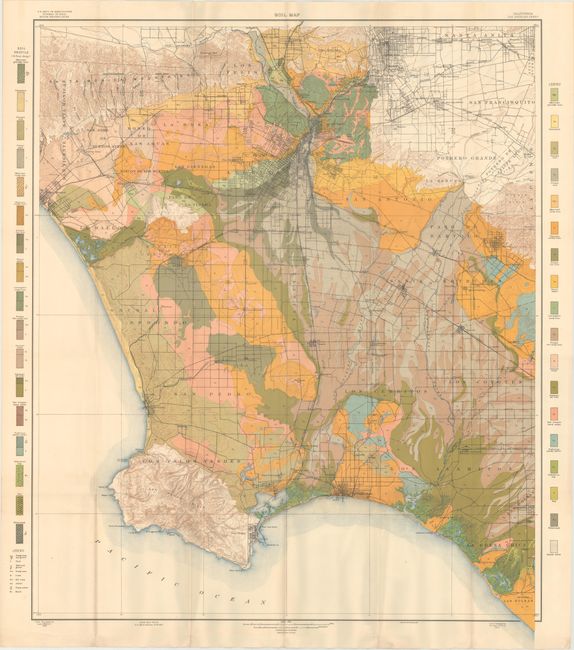
Auction 172, Lot 117
Subject: United States
U.S.D.A.
[Lot of 78 - U.S.D.A. Soil Maps], 1903
Size: 6.1 x 9.4 inches (15.5 x 23.9 cm)
Estimate: $300 - $375
Features Maps of Los Angeles, San Jose, and New Orleans
Sold for: $210
Closed on 4/17/2019
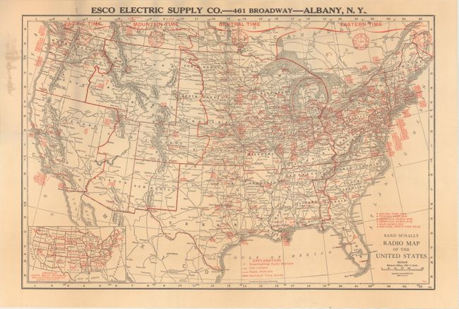
Auction 172, Lot 118
Subject: United States
Rand McNally & Co.
Radio Map of the United States, 1924
Size: 18.9 x 12.5 inches (48 x 31.8 cm)
Estimate: $160 - $190
Sold for: $80
Closed on 4/17/2019
Auction 172, Lot 119
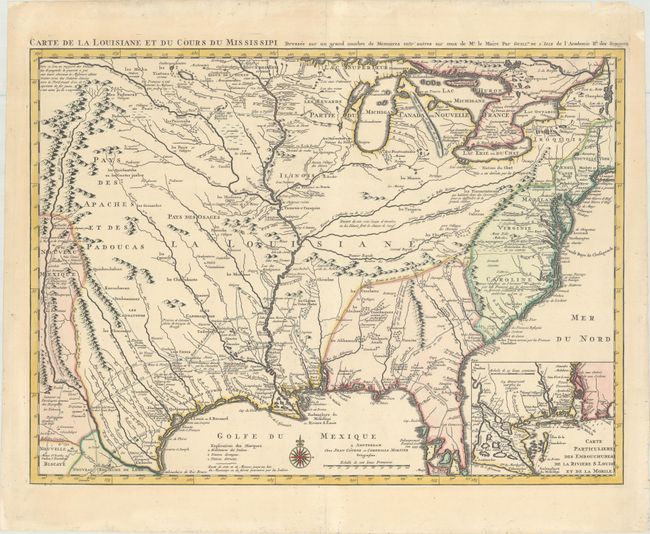
Subject: Colonial Eastern United States, Louisiana Territory
Delisle/Covens & Mortier
Carte de la Louisiane et du Cours du Mississipi Dressee sur un Grand Nombre de Memoires Entr'autres sur ceux de Mr. le Maire, 1730
Size: 23.4 x 17.3 inches (59.4 x 43.9 cm)
Estimate: $1,800 - $2,200
Delisle's Influential Map of the Louisiana Territory
Unsold
Closed on 4/17/2019

Auction 172, Lot 120
Subject: Colonial Eastern United States
Anon.
An Accurate Map of the English Colonies in North America Bordering on the River Ohio, 1754
Size: 9.6 x 7.9 inches (24.4 x 20.1 cm)
Estimate: $550 - $700
Sold for: $400
Closed on 4/17/2019
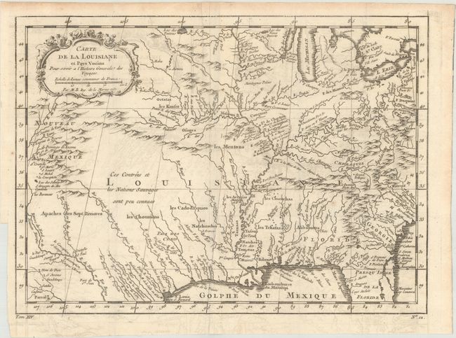
Auction 172, Lot 121
Subject: Colonial Eastern United States
Bellin, Jacques Nicolas
[Lot of 2] Carte de la Louisiane et Pays Voisins pour Servir a l'Histoire Generale des Voyages [and] Carte de la Nouvelle Angleterre Nouvelle Yorck et Pensilvanie..., 1757
Size: 11.9 x 8.6 inches (30.2 x 21.8 cm)
Estimate: $300 - $375
Sold for: $325
Closed on 4/17/2019
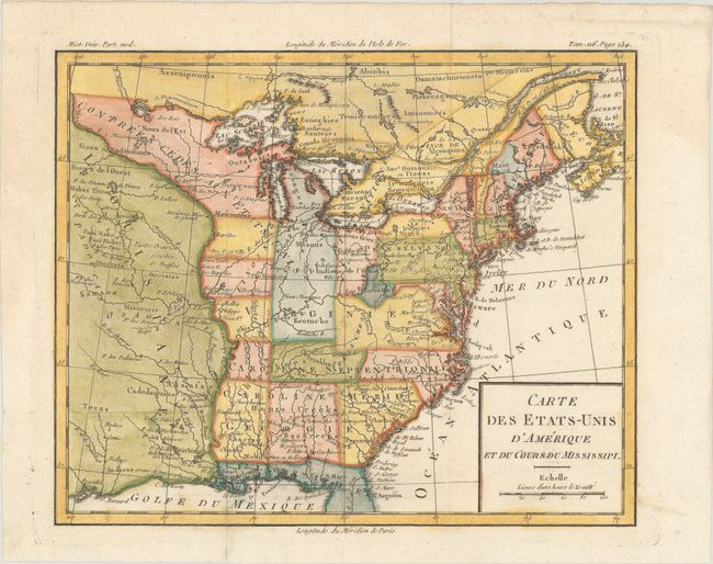
Auction 172, Lot 122
Subject: Eastern United States, Franklin
Brion de la Tour, Louis
Carte des Etats-Unis d'Amerique et du Cours du Mississipi, 1788
Size: 10.6 x 8.6 inches (26.9 x 21.8 cm)
Estimate: $800 - $950
One of the Earliest Maps to Feature the State of Franklin
Sold for: $3,750
Closed on 4/17/2019
Auction 172, Lot 123
Subject: Eastern United States
[Lot of 3] United States [and] United States [and] United States, 1800-27
Size: 9.4 x 7.5 inches (23.9 x 19.1 cm)
Estimate: $200 - $230
Sold for: $150
Closed on 4/17/2019
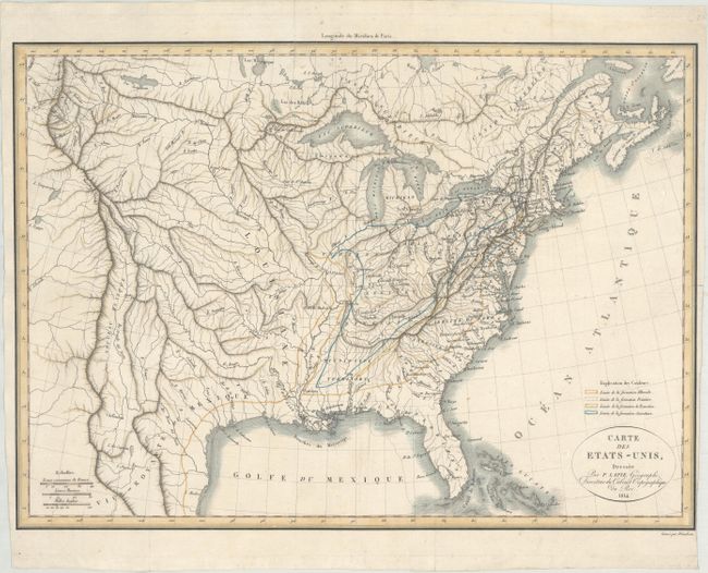
Auction 172, Lot 124
Subject: Eastern United States
Lapie, Alexander Emile & Pierre
Carte des Etats-Unis, 1814
Size: 17.8 x 12.8 inches (45.2 x 32.5 cm)
Estimate: $550 - $650
Unsold
Closed on 4/17/2019
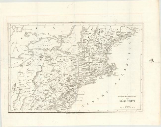
Auction 172, Lot 125
Subject: Eastern United States
Botta, Carlo
[Lot of 2] Le Provincie Settentrionali degli Stati Uniti [with] Le Provincie Meridionali degli Stati Uniti, 1826
Size: 17.4 x 12.4 inches (44.2 x 31.5 cm)
Estimate: $300 - $375
Unsold
Closed on 4/17/2019
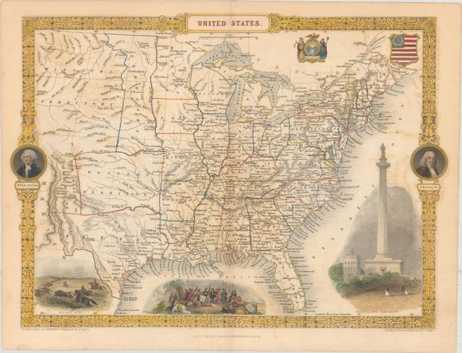
Auction 172, Lot 126
Subject: Eastern United States
Tallis, John
United States, 1851
Size: 13.4 x 9.6 inches (34 x 24.4 cm)
Estimate: $240 - $300
Sold for: $475
Closed on 4/17/2019
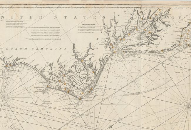
Auction 172, Lot 127
Subject: Eastern United States
Norie, John William
To the Independent Mariners of America, This Chart of Their Coast from Savannah to Boston Is Most Respectfully Dedicated..., 1852
Size: 61.5 x 25.4 inches (156.2 x 64.5 cm)
Estimate: $1,800 - $2,100
Rare Blue-Back Chart of the East Coast
Sold for: $1,300
Closed on 4/17/2019
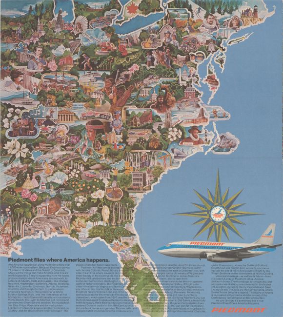
Auction 172, Lot 128
Subject: Eastern United States
[Lot of 3] Piedmont Airlines - Route Map [and] The Capital Way to Go Places... [and] North Central Airlines - Route of the Northliners, 1950-60
Size: See Description
Estimate: $120 - $150
Unsold
Closed on 4/17/2019
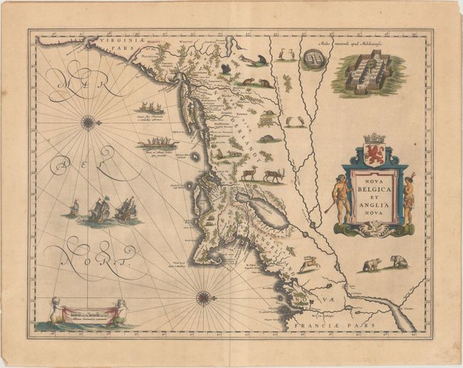
Auction 172, Lot 129
Subject: Colonial New England & Mid-Atlantic United States
Blaeu, Willem
Nova Belgica et Anglia Nova, 1635
Size: 19.9 x 15.3 inches (50.5 x 38.9 cm)
Estimate: $2,200 - $2,500
Important Map of Colonial New England and the Mid-Atlantic in Contemporary Color
Sold for: $1,600
Closed on 4/17/2019
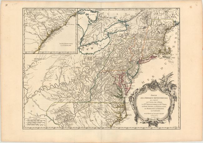
Auction 172, Lot 130
Subject: Colonial New England & Mid-Atlantic United States
Robert de Vaugondy, Didier
Partie de l'Amerique Septentrionale, qui Comprend le Cours de l'Ohio, la Nlle. Angleterre, la Nlle York, le New Jersey, la Pensylvanie, le Maryland la Virginie, la Caroline, 1755
Size: 24.5 x 18.8 inches (62.2 x 47.8 cm)
Estimate: $650 - $800
First State
Sold for: $475
Closed on 4/17/2019
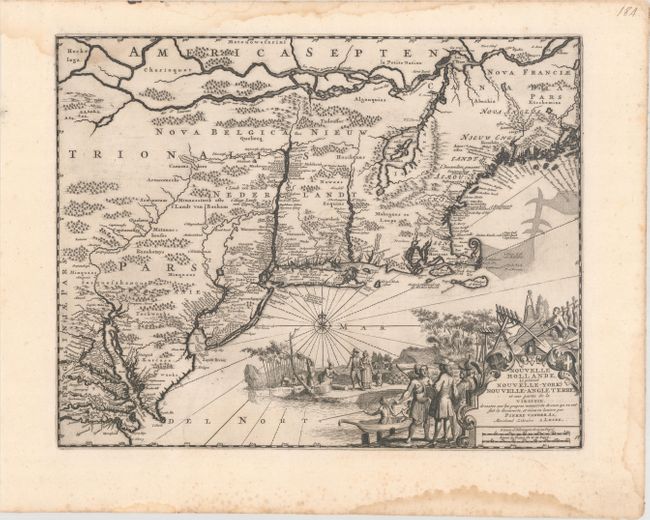
Auction 172, Lot 131
Subject: Colonial New England United States
Aa, Pieter van der
Nouvelle Hollande, (a present Nouvelle-York) Nouvelle-Angleterre, et Une Partie de la Virginie..., 1729
Size: 14.4 x 11.4 inches (36.6 x 29 cm)
Estimate: $900 - $1,100
Unsold
Closed on 4/17/2019
Auction 172, Lot 132
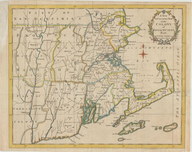
Subject: Colonial New England United States
Anon.
A New and Accurate Map of the Colony of Massachusets Bay, in North America from a Late Survey, 1780
Size: 12.8 x 10.4 inches (32.5 x 26.4 cm)
Estimate: $325 - $400
Sold for: $300
Closed on 4/17/2019
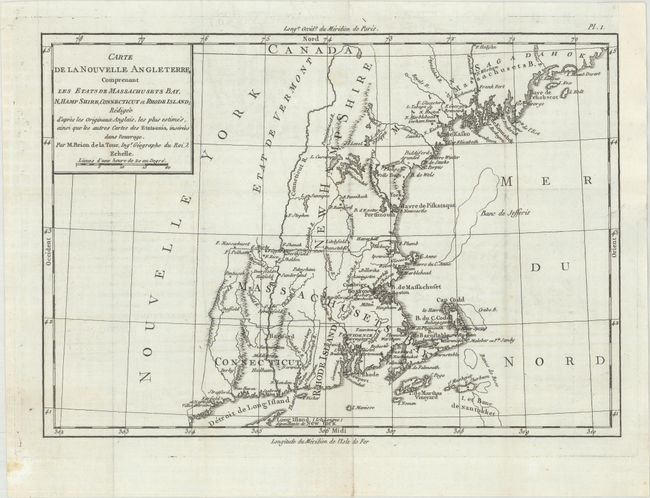
Auction 172, Lot 133
Subject: Colonial New England United States
Brion de la Tour, Louis
Carte de la Nouvelle Angleterre, Comprenant les Etats de Massachusets Bay, N. Hamp Shire, Connecticut et Rhode Island..., 1782
Size: 12.8 x 8.9 inches (32.5 x 22.6 cm)
Estimate: $250 - $325
Unsold
Closed on 4/17/2019
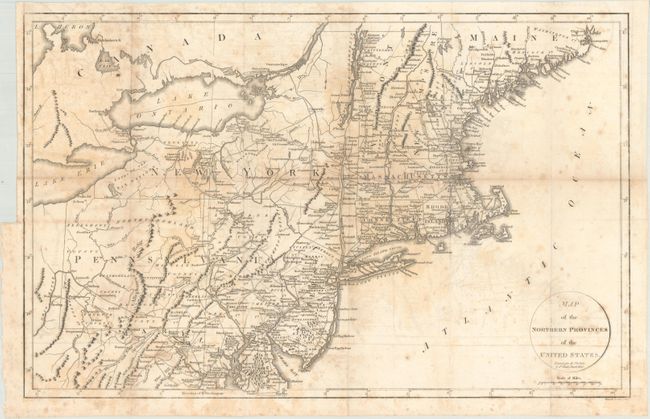
Auction 172, Lot 134
Subject: New England - United States
Phillips, Richard (Sir)
Map of the Northern Provinces of the United States, 1804
Size: 20.1 x 12.8 inches (51.1 x 32.5 cm)
Estimate: $250 - $325
Unsold
Closed on 4/17/2019
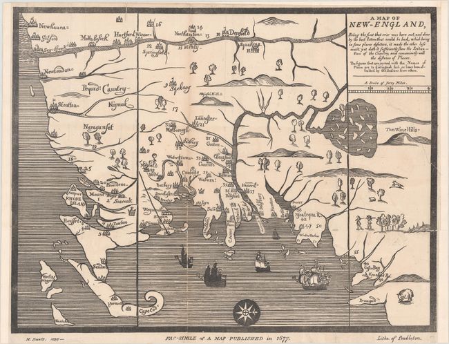
Auction 172, Lot 135
Subject: New England United States
Pendleton, John B.
[Facsimile] A Map of New-England, Being the First That Ever Was Here Cut, and Done by the Best Pattern That Could Be Had..., 1826
Size: 15.3 x 11.8 inches (38.9 x 30 cm)
Estimate: $650 - $800
Sold for: $475
Closed on 4/17/2019
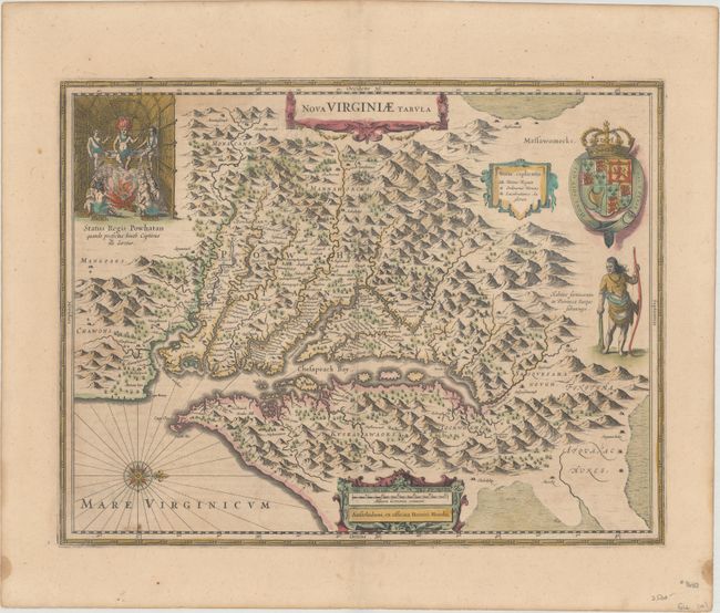
Auction 172, Lot 136
Subject: Colonial Mid-Atlantic United States
Jansson, Jan
Nova Virginiae Tabula, 1631
Size: 7.5 x 5.2 inches (19.1 x 13.2 cm)
Estimate: $550 - $700
Unsold
Closed on 4/17/2019
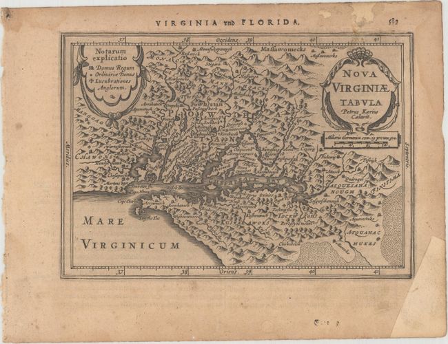
Auction 172, Lot 137
Subject: Colonial Mid-Atlantic United States
Hondius, Henricus
Nova Virginiae Tabula, 1638
Size: 19.4 x 14.9 inches (49.3 x 37.8 cm)
Estimate: $1,800 - $2,200
One of the Most Important 17th Century Maps of the Chesapeake Bay in Full Contemporary Color
Sold for: $1,300
Closed on 4/17/2019
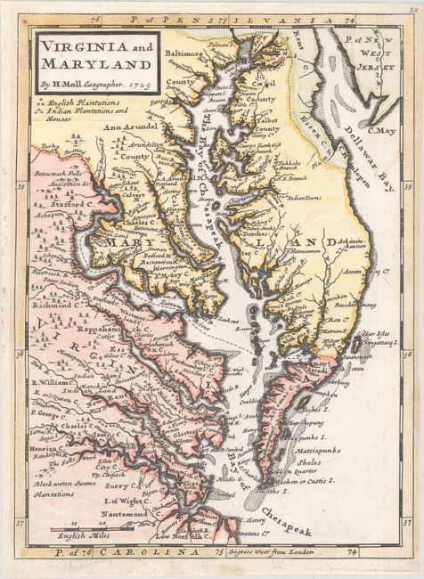
Auction 172, Lot 138
Subject: Colonial Mid-Atlantic United States
Moll, Herman
Virginia and Maryland, 1729
Size: 7.8 x 10.6 inches (19.8 x 26.9 cm)
Estimate: $600 - $750
Sold for: $450
Closed on 4/17/2019
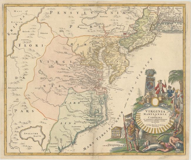
Auction 172, Lot 139
Subject: Colonial Mid-Atlantic United States
Homann, Johann Baptist
Virginia Marylandia et Carolina in America Septentrionali Britannorum Industria Excultae Repraesentatae, 1730
Size: 22.8 x 19.1 inches (57.9 x 48.5 cm)
Estimate: $1,600 - $2,000
Map Created to Promote German Immigration to the New World
Unsold
Closed on 4/17/2019
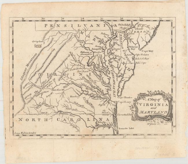
Auction 172, Lot 140
Subject: Colonial Mid-Atlantic United States
Salmon, Thomas
A Map of Virginia and Maryland, 1767
Size: 7.8 x 5.7 inches (19.8 x 14.5 cm)
Estimate: $400 - $475
Unsold
Closed on 4/17/2019
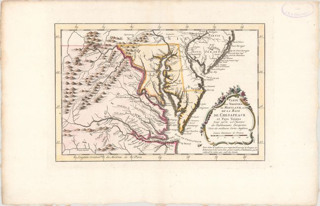
Auction 172, Lot 141
Subject: Colonial Mid-Atlantic United States
Bellin, Jacques Nicolas
Carte de la Virginie et du Maryland, ou de la Baie de Chesapeack et Pays Voisins pour Servir a l'Histoire des Etablissemens Europeens..., 1773
Size: 11.2 x 7.4 inches (28.4 x 18.8 cm)
Estimate: $325 - $400
Sold for: $240
Closed on 4/17/2019
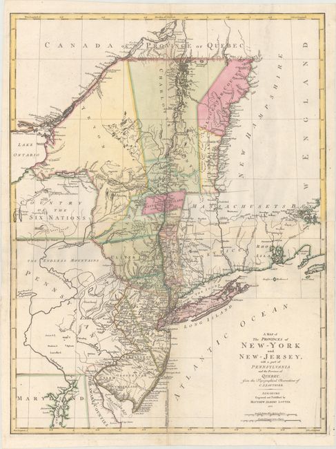
Auction 172, Lot 142
Subject: Colonial Mid-Atlantic United States
Lotter, Mathias Albrecht
A Map of the Provinces of New-York and New-Jersey, with a part of Pennsylvania and the Province of Quebec, from the Topographical Observations of C. J. Sauthier, 1777
Size: 22.3 x 29.5 inches (56.6 x 74.9 cm)
Estimate: $1,900 - $2,200
Important Revolutionary War Map
Sold for: $1,600
Closed on 4/17/2019
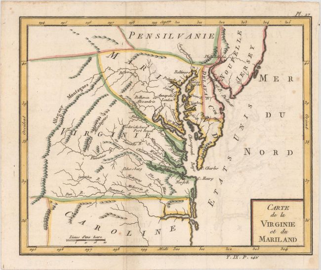
Auction 172, Lot 143
Subject: Mid-Atlantic United States
Laporte, Joseph de
Carte de la Virginie et du Mariland, 1783
Size: 8.6 x 7 inches (21.8 x 17.8 cm)
Estimate: $275 - $350
Sold for: $140
Closed on 4/17/2019
198 lots
Page 1 of 4