Catalog Archive
Auction 172, Lot 101

"Map Showing the Route of the Canada Southern Railway and Its Connecting Lines [bound in] The Canada Southern Railway Company. Prospectus, Reports and Other Documents", Colton, G.W. & C.B.

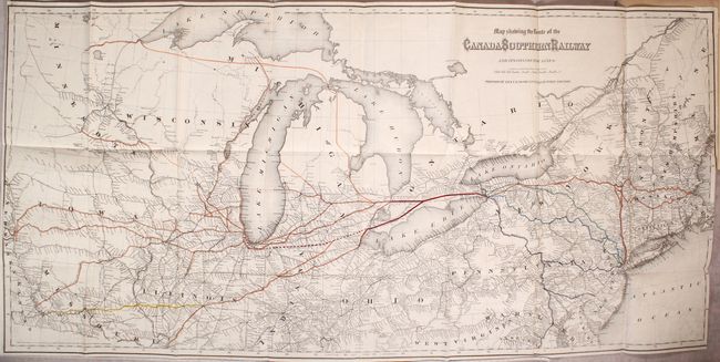
Subject: Eastern United States & Canada

Period: 1872 (published)

Publication:

Color: Hand Color

Size:
38.5 x 18.4 inches
97.8 x 46.7 cm
Download High Resolution Image
(or just click on image to launch the Zoom viewer)

This uncommon map shows the railroad network from the Eastern Seaboard to the Missouri River with an emphasis on a proposed extension of the Canada Southern Railway (dotted red line) that would lead from Grosse Ile, Michigan to Chicago. The Great Panic of 1873 put a stop to the railroad’s completion and it only went as far as Fayette, Ohio even though much of the route had been readied for tracks (this route later became part of the Michigan Southern Railway system). The map is still bound to the 68 page prospectus it was designed for and still includes two unsigned $1,000 bonds.

References:

Condition: A

Condition code is for the map, which is near fine with a hint of offsetting. Text is very good with light toning along the sheet edges. Paper wrappers have average wear.

Estimate: $200 - $250

Sold for: $150

Closed on 4/17/2019

Archived