Subject: New England United States
Period: 1826 (dated)
Publication:
Color: Black & White
Size:
15.3 x 11.8 inches
38.9 x 30 cm
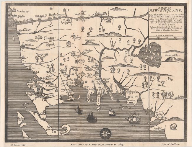
This is a facsimile edition of a 1677 map issued in William Hubbard's A Narrative of the Troubles with the Indians (London edition). It covers the region from New Haven north to Casco Bay, including Cape Cod, Martha's Vineyard, and Nantucket. While the map appears rather basic in execution, it was relatively advanced for its time with numerous towns identified, the vertical boundaries of Massachusetts Bay Colony delineated, and a relatively accurate representation of Lake Winnipesaukee. Numbered towns (which are the majority) represent those that suffered from Indian attacks during King Philip’s War (1675-76).
While a facsimile edition, this map is important by its own accord as an early example of American lithography. It is one of the first maps issued by the Boston-based Pendleton Firm, which was established in 1825 and considered the first successful lithographic printer in the United States.
References: cf. McCorkle #677.3; Ristow (TMC-21) pp. 26-31.
Condition: B
Backed with linen to reinforce and repair several small fold separations and a 6" tear in the upper right corner of the image. The margins have been extended at top, right, and left to better accommodate framing.