Filtered by Category:United States(Show All Categories)
Showing results for:Auction 166
Catalog Archive
217 lots
Page 1 of 5
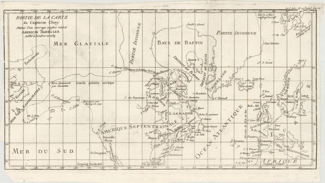
Auction 166, Lot 100
Subject: Colonial United States, Canada & Arctic
Robert de Vaugondy, Didier
Partie de la Carte du Capitaine Cluny Auteur d'un Ouvrage Anglois Intitule American Traveller Publie a Londres en 1769, 1773
Size: 16.1 x 8.4 inches (40.9 x 21.3 cm)
Estimate: $100 - $130
Sold for: $75
Closed on 2/14/2018
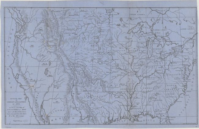
Auction 166, Lot 101
Subject: United States & Canada
Catlin, George
Outline Map of Indian Localities in 1833, 1892
Size: 14.4 x 8.8 inches (36.6 x 22.4 cm)
Estimate: $100 - $130
Sold for: $200
Closed on 2/14/2018
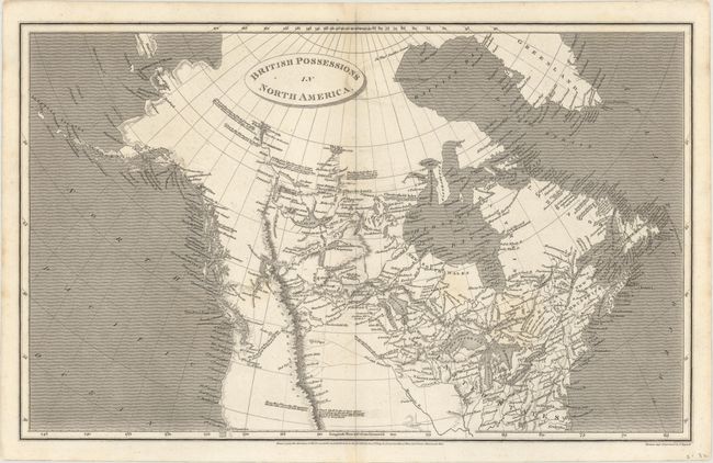
Auction 166, Lot 102
Subject: Northern United States & Canada
Arrowsmith, Aaron, Sr.
British Possessions in North America, 1809
Size: 15.7 x 9.8 inches (39.9 x 24.9 cm)
Estimate: $160 - $200
Sold for: $130
Closed on 2/14/2018
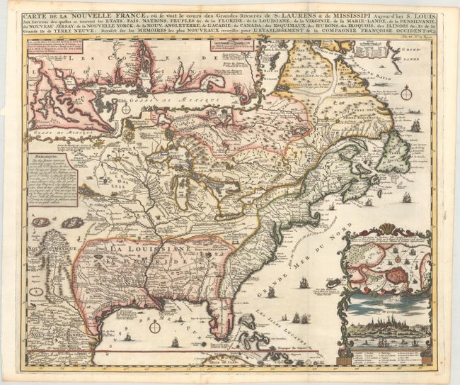
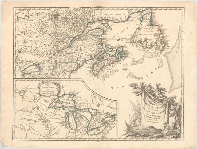
Auction 166, Lot 103
Subject: Colonial Eastern United States & Canada
Chatelain, Henry Abraham
Carte de la Nouvelle France, ou se Voit le Cours des Grandes Rivieres de S. Laurens & de Mississipi Aujour d'hui S. Louis, aux Environs des-quelles se Trouvent les Etats, Pais, Nations, Peuples &c..., 1719
Size: 19.2 x 16.6 inches (48.8 x 42.2 cm)
Estimate: $3,000 - $3,750
One of the Most Informative 18th Century Maps of the French Possessions in North America
Sold for: $3,250
Closed on 2/14/2018
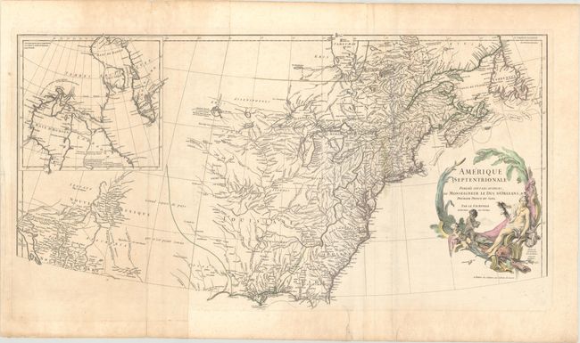
Auction 166, Lot 104
Subject: Colonial Eastern United States & Canada
Anville, Jean Baptiste Bourguignon d'
Amerique Septentrionale Publiee sous les Auspices de Monseigneur de Duc d'Orleans Premier Prince du Sang, 1746
Size: 34.2 x 17.8 inches (86.9 x 45.2 cm)
Estimate: $600 - $750
Sold for: $390
Closed on 2/14/2018
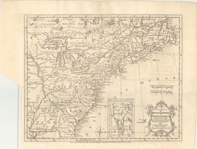
Auction 166, Lot 105
Subject: Colonial Eastern United States & Canada
Kitchin, Thomas
A New Map of the British Dominions in North America; with the Limits of the Governments Annexed Thereto by the Late Treaty of Peace, and Settled by Proclamation, October 7th, 1763, 1763
Size: 11.9 x 9.6 inches (30.2 x 24.4 cm)
Estimate: $350 - $425
Sold for: $275
Closed on 2/14/2018
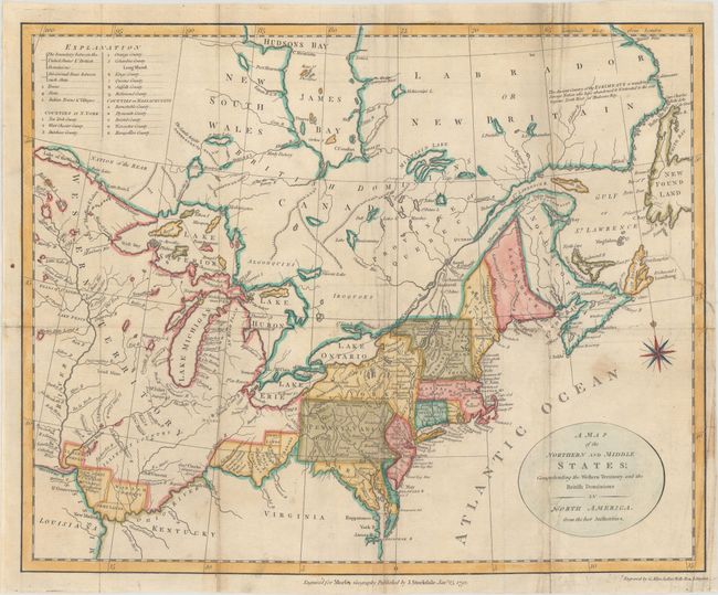
Auction 166, Lot 106
Subject: Eastern United States & Canada
Stockdale, John
A Map of the Northern and Middle States; Comprehending the Western Territory and the British Dominions in North America. From the Best Authorities, 1792
Size: 15.2 x 12.3 inches (38.6 x 31.2 cm)
Estimate: $300 - $375
Sold for: $240
Closed on 2/14/2018
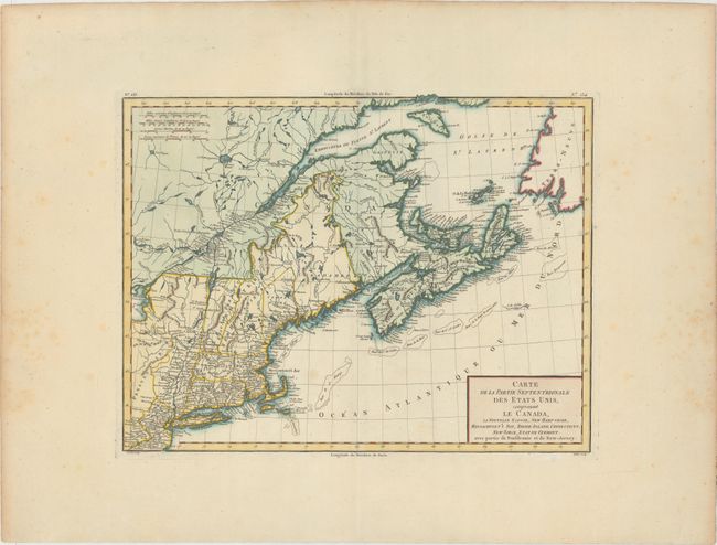
Auction 166, Lot 107
Subject: Eastern United States & Canada
Tardieu, Pierre Francois
Carte de la Partie Septentrionale des Etats Unis, Comprenant le Canada, la Nouvelle Ecosse, New Hampshire, Massachuset's Bay, Rhode-Island, Connecticut, New Yorck, Etat de Vermont avec Partie de Pensilvanie et de New-Jersey, 1797
Size: 16.6 x 12.7 inches (42.2 x 32.3 cm)
Estimate: $275 - $350
Unsold
Closed on 2/14/2018
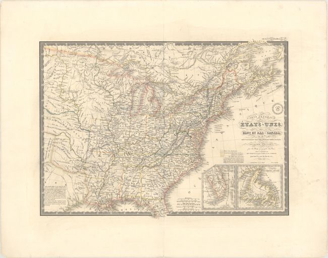
Auction 166, Lot 108
Subject: Eastern United States & Canada
Brue, Adrien Hubert
Carte Generale des Etats-Unis, des Haut et Bas-Canada, de la Nouvle. Ecosse, du Nouvau Brunswick, de Terre-Neuve, &a. Seconde Edition, 1840
Size: 20.3 x 14.6 inches (51.6 x 37.1 cm)
Estimate: $180 - $210
Unsold
Closed on 2/14/2018
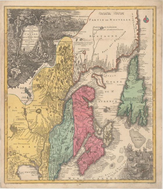
Auction 166, Lot 109
Subject: Colonial New England & Canada
Seutter/Lotter
Partie Orientale de la Nouvelle France ou du Canada avec l'Isle de Terre-Neuve et de Nouvelle Escosse, Acadie et Nouv. Angleterre..., 1740
Size: 19.4 x 22.6 inches (49.3 x 57.4 cm)
Estimate: $900 - $1,100
Sold for: $650
Closed on 2/14/2018
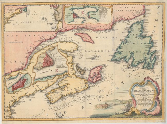
Auction 166, Lot 110
Subject: Colonial New England & Canada
Jefferys, Thomas
A New Chart of the Coast of New England, Nova Scotia New France or Canada, with the Islands of Newfoundld. Cape Breton St. John's &c. Done from the Original Publish'd in 1744..., 1746
Size: 18 x 13.2 inches (45.7 x 33.5 cm)
Estimate: $275 - $350
Sold for: $275
Closed on 2/14/2018
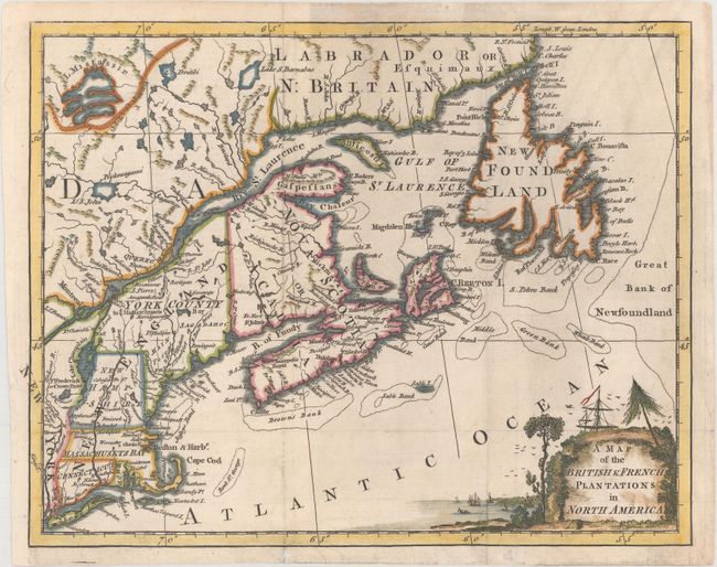
Auction 166, Lot 111
Subject: Colonial New England & Canada
Anon.
A Map of the British & French Plantations in North America, 1755
Size: 10.5 x 8.2 inches (26.7 x 20.8 cm)
Estimate: $240 - $300
Sold for: $140
Closed on 2/14/2018
Auction 166, Lot 112
Subject: Colonial Northeastern United States & Canada, Great Lakes
Robert de Vaugondy, Didier
Partie de l'Amerique Septent? qui Comprend la Nouvelle France ou le Canada, 1755
Size: 23.9 x 19 inches (60.7 x 48.3 cm)
Estimate: $600 - $750
Unsold
Closed on 2/14/2018
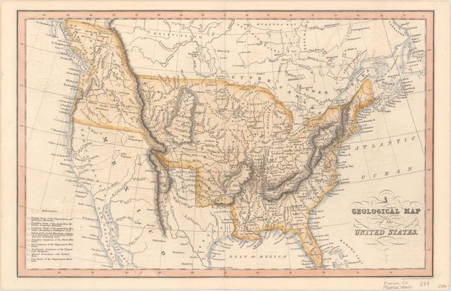
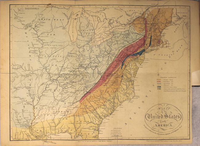
Auction 166, Lot 113
Subject: United States
Hinton, John Howard
A Geological Map of the United States, 1832
Size: 15.3 x 9.8 inches (38.9 x 24.9 cm)
Estimate: $250 - $325
Sold for: $180
Closed on 2/14/2018
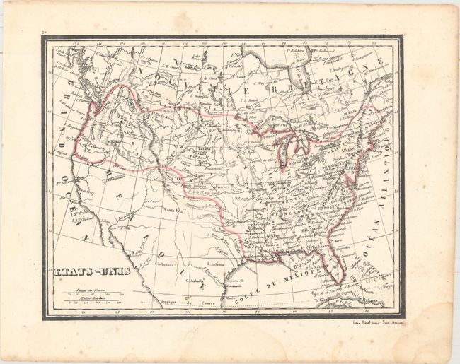
Auction 166, Lot 114
Subject: United States
Etats-Unis, 1840
Size: 10 x 7.8 inches (25.4 x 19.8 cm)
Estimate: $110 - $140
Sold for: $80
Closed on 2/14/2018
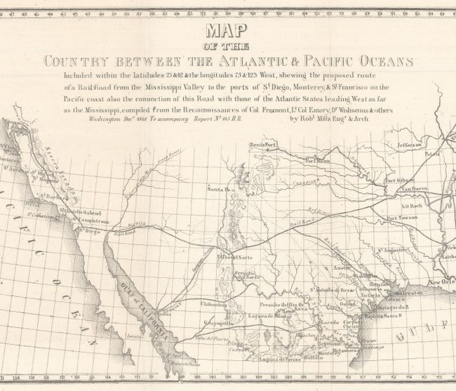
Auction 166, Lot 115
Subject: United States
Mills, Robert
Map of the Country Between the Atlantic & Pacific Oceans..., 1852
Size: 32 x 10.5 inches (81.3 x 26.7 cm)
Estimate: $120 - $150
Sold for: $110
Closed on 2/14/2018
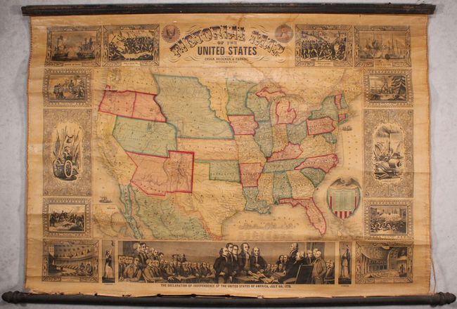
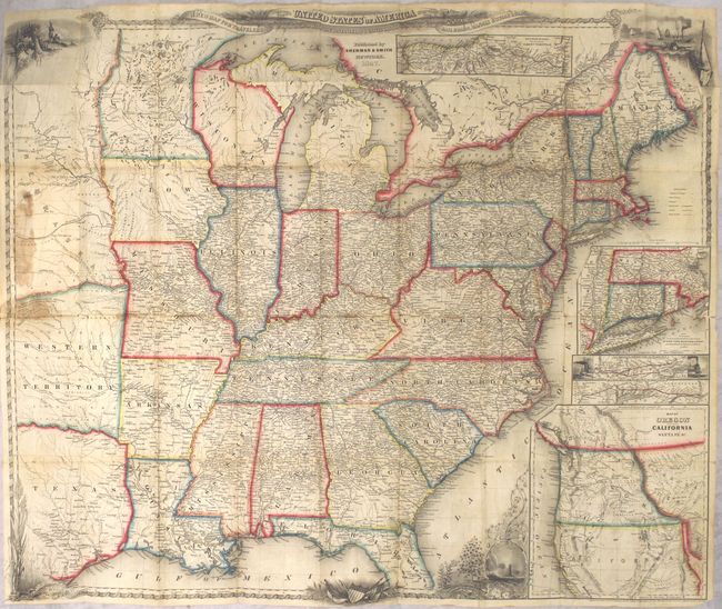
Auction 166, Lot 116
Subject: United States
Ensign, Bridgman & Fanning
Pictorial Map of the United States, 1858
Size: 39.5 x 27.5 inches (100.3 x 69.9 cm)
Estimate: $1,000 - $1,300
Sold for: $850
Closed on 2/14/2018
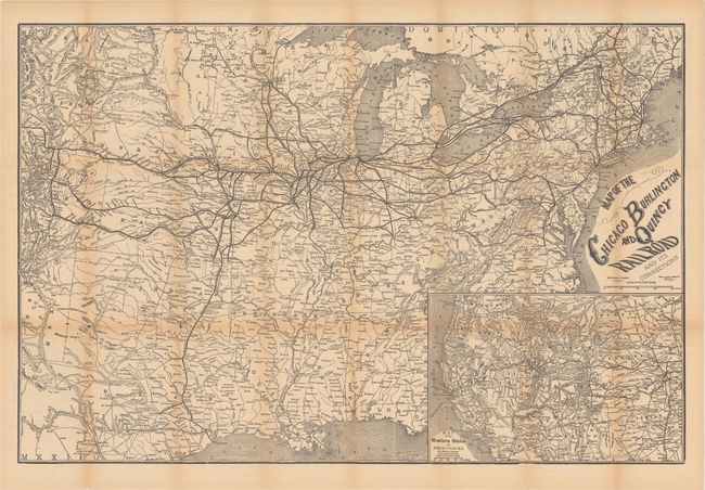
Auction 166, Lot 117
Subject: United States, Railroads
Rand McNally & Co.
Map of the Chicago Burlington and Quincy Railroad and Its Connections, 1878
Size: 29.9 x 19.9 inches (75.9 x 50.5 cm)
Estimate: $150 - $180
Unsold
Closed on 2/14/2018
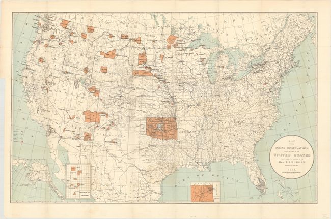
Auction 166, Lot 118
Subject: United States
U.S. Bureau of Indian Affairs
Map Showing Indian Reservations Within the Limits of the United States, 1889
Size: 33.4 x 20.9 inches (84.8 x 53.1 cm)
Estimate: $140 - $170
Sold for: $100
Closed on 2/14/2018
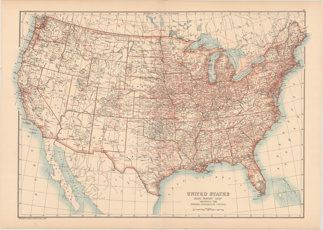
Auction 166, Lot 119
Subject: United States
Black, Adam & Charles
United States Rail Road Map Showing the Principal Topographical Features, 1896
Size: 23.1 x 16.1 inches (58.7 x 40.9 cm)
Estimate: $80 - $95
Sold for: $60
Closed on 2/14/2018
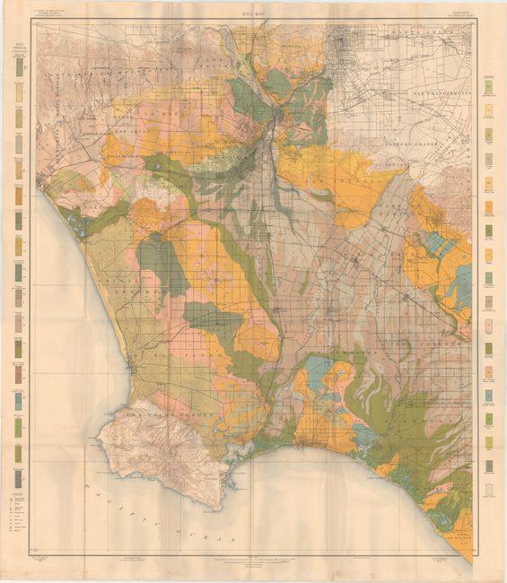
Auction 166, Lot 120
Subject: United States
U.S.D.A.
[Lot of 79 - U.S.D.A. Soil Maps], 1903
Size: 5.6 x 9.5 inches (14.2 x 24.1 cm)
Estimate: $400 - $500
Features Maps of Los Angeles and New Orleans
Unsold
Closed on 2/14/2018
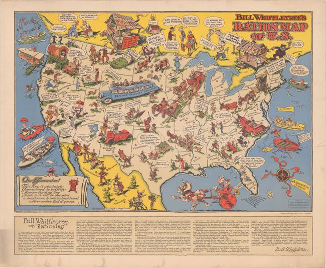
Auction 166, Lot 121
Subject: United States, World War II
[Lot of 2] Bill Whiffletree's Ration Map of U.S. [and] Bill Whiffletree's Bootleggers' Map of the United States, 1944
Size: 30.1 x 20.2 inches (76.5 x 51.3 cm)
Estimate: $3,000 - $4,000
Matching Pair Featuring the Extremely Rare "Ration Map"
Sold for: $2,000
Closed on 2/14/2018
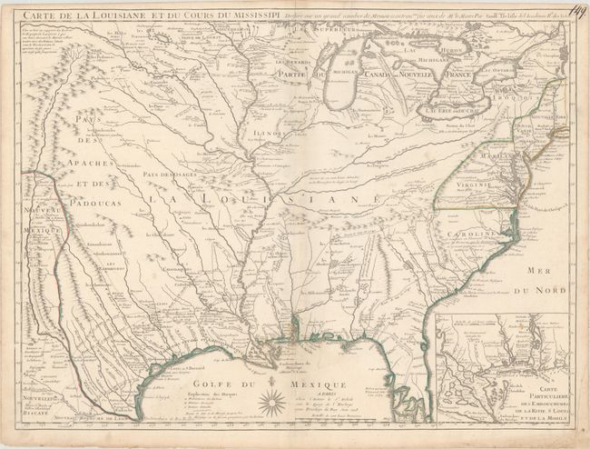
Auction 166, Lot 122
Subject: Colonial Eastern United States
Delisle, Guillaume
Carte de la Louisiane et du Cours du Mississipi Dressee sur un Grand Nombre de Memoires Entrautres sur ceux de Mr. le Maire, 1718
Size: 25.3 x 19.1 inches (64.3 x 48.5 cm)
Estimate: $7,500 - $9,000
A Foundation Map for the Mississippi Valley and the First Appearance of Texas on a Printed Map
Unsold
Closed on 2/14/2018
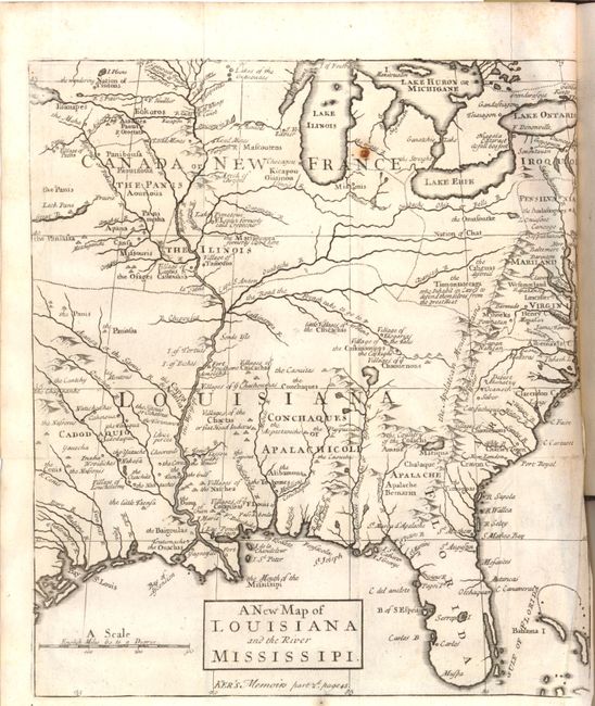
Auction 166, Lot 123
Subject: Colonial Eastern United States
Anon.
A New Map of Louisiana and the River Mississipi [within book] The Memoirs and Secret Negotiations of John Ker, 1726
Size: 9 x 10.2 inches (22.9 x 25.9 cm)
Estimate: $700 - $850
Unsold
Closed on 2/14/2018
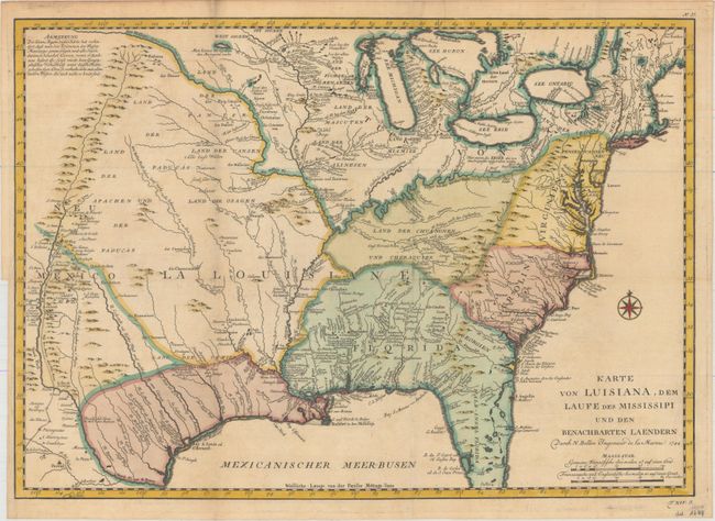
Auction 166, Lot 124
Subject: Colonial Eastern United States
Bellin, Jacques Nicolas
Karte von Luisiana, dem Laufe des Mississipi und den Benachbarten Laendern…, 1744
Size: 22 x 15.5 inches (55.9 x 39.4 cm)
Estimate: $700 - $850
Sold for: $400
Closed on 2/14/2018
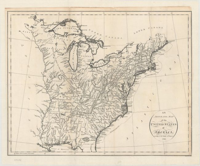
Auction 166, Lot 125
Subject: Eastern United States
Russell, John C.
An Accurate Map of the United States of America, According to the Treaty of Peace of 1783, 1794
Size: 18.4 x 14.5 inches (46.7 x 36.8 cm)
Estimate: $375 - $450
Sold for: $250
Closed on 2/14/2018
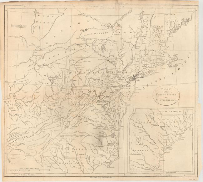
Auction 166, Lot 126
Subject: Eastern United States
Stockdale, John
Part of the United States of North America, 1798
Size: 18.4 x 16.2 inches (46.7 x 41.1 cm)
Estimate: $220 - $250
Unsold
Closed on 2/14/2018
Auction 166, Lot 127
Subject: Eastern United States
Melish, John
Map of the United States of America, 1812
Size: 17.2 x 13.1 inches (43.7 x 33.3 cm)
Estimate: $900 - $1,100
Sold for: $550
Closed on 2/14/2018
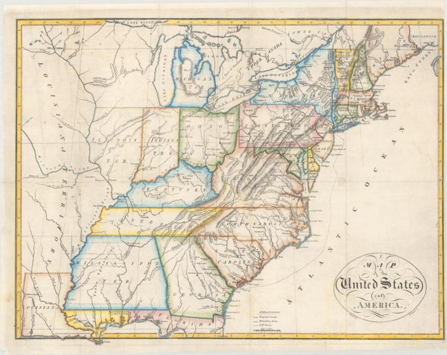
Auction 166, Lot 128
Subject: Eastern United States
Maclure, William
Map of the United States of America [in book] Observations on the Geology of the United States of America; with Some Remarks on the Effect Produced on the Nature and Fertility of Soils..., 1817
Size: 17.4 x 13.8 inches (44.2 x 35.1 cm)
Estimate: $900 - $1,100
One of the Earliest Geological Maps of the United States
Sold for: $650
Closed on 2/14/2018
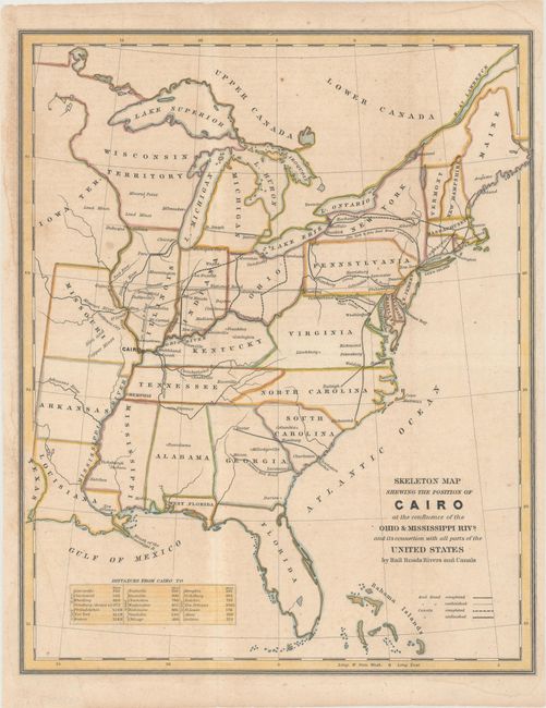
Auction 166, Lot 129
Subject: Eastern United States
U.S. Government
Skeleton Map Shewing the Position of Cairo at the Confluence of the Ohio & Mississippi Rivs. and Its Connection with All Parts of the United States by Rail Roads Rivers and Canals, 1836
Size: 11.8 x 14.6 inches (30 x 37.1 cm)
Estimate: $160 - $190
Sold for: $120
Closed on 2/14/2018
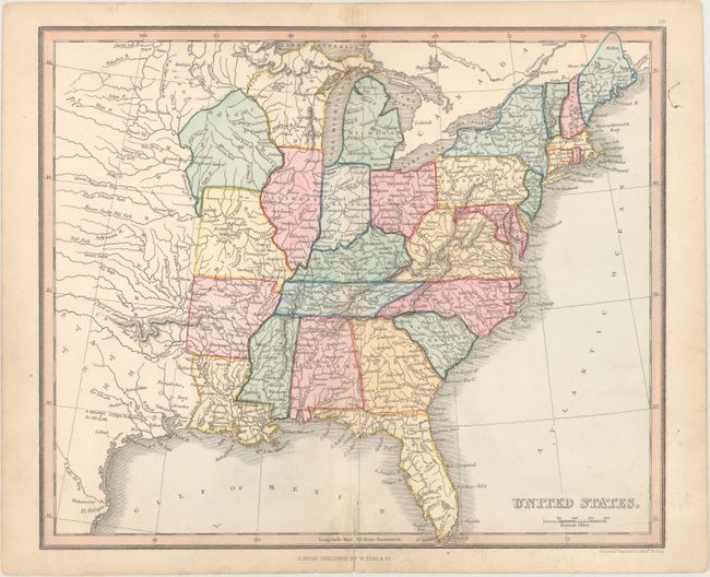
Auction 166, Lot 130
Subject: Eastern United States
Findlay, Alexander
United States, 1843
Size: 10.3 x 8.6 inches (26.2 x 21.8 cm)
Estimate: $100 - $130
Sold for: $75
Closed on 2/14/2018
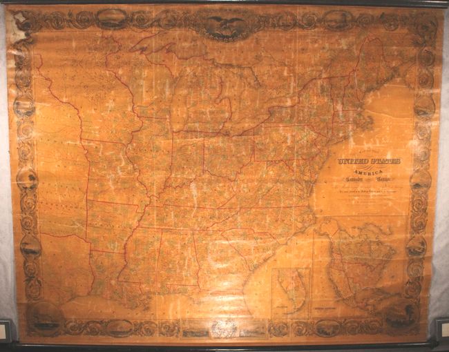
Auction 166, Lot 131
Subject: Eastern United States, Texas
Smith, J. Calvin
Map of the United States of America Including Canada and a Large Portion of Texas..., 1844
Size: 79 x 63 inches (200.7 x 160 cm)
Estimate: $3,500 - $4,500
Enormous Wall Map Featuring an Independent Texas
Sold for: $1,800
Closed on 2/14/2018
Auction 166, Lot 132
Subject: Eastern United States
Smith, J. Calvin
A New Map for Travelers Through the United States of America Showing the Railroads, Canal & Stage Roads. With the Distances [in] The Illustrated Hand-Book, a New Guide for Travelers Through the United States of America..., 1847
Size: 26.3 x 21.8 inches (66.8 x 55.4 cm)
Estimate: $700 - $850
Sold for: $500
Closed on 2/14/2018
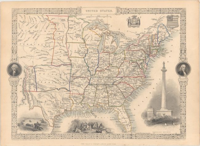
Auction 166, Lot 133
Subject: Eastern United States
Tallis, John
United States, 1851
Size: 13.5 x 9.7 inches (34.3 x 24.6 cm)
Estimate: $240 - $300
Sold for: $145
Closed on 2/14/2018
Auction 166, Lot 134
Subject: Eastern United States, Civil War
[Bound Lot of 19 Maps from Historie de la Guerre Civile en Amerique], 1883
Size: 13 x 17.5 inches (33 x 44.5 cm)
Estimate: $500 - $650
Uncommon Set of French Civil War Maps
Sold for: $240
Closed on 2/14/2018
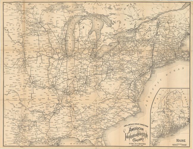
Auction 166, Lot 135
Subject: Eastern United States
Lines and Metallic Circuit Connections American Telephone and Telegraph Company , 1898
Size: 28.9 x 22.8 inches (73.4 x 57.9 cm)
Estimate: $250 - $325
Scarce AT&T Advertising Piece
Sold for: $130
Closed on 2/14/2018
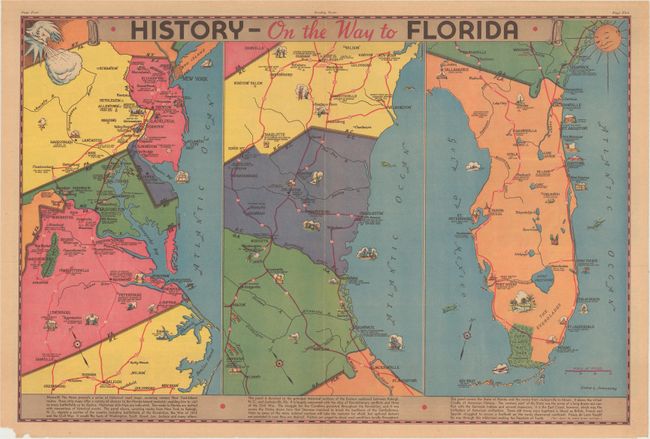
Auction 166, Lot 136
Subject: Eastern United States
History - On the Way to Florida, 1935
Size: 21.7 x 14.5 inches (55.1 x 36.8 cm)
Estimate: $50 - $70
NO RESERVE
Sold for: $36
Closed on 2/14/2018
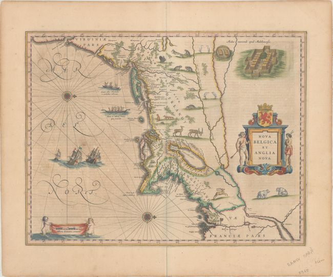
Auction 166, Lot 137
Subject: Colonial New England & Mid-Atlantic United States
Blaeu, Willem
Nova Belgica et Anglia Nova, 1642
Size: 19.9 x 15.3 inches (50.5 x 38.9 cm)
Estimate: $2,200 - $2,500
Important Map of Colonial New England and the Mid-Atlantic
Sold for: $1,600
Closed on 2/14/2018
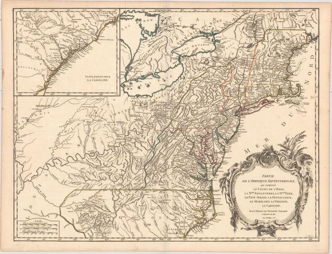
Auction 166, Lot 138
Subject: Colonial New England & Mid-Atlantic United States
Robert de Vaugondy, Didier
Partie de l'Amerique Septentrionale, qui Comprend le Cours de l'Ohio, la Nlle. Angleterre, la Nlle York, le New Jersey, la Pensylvanie, le Maryland la Virginie, la Caroline, 1755
Size: 24.6 x 18.9 inches (62.5 x 48 cm)
Estimate: $600 - $750
First State
Sold for: $650
Closed on 2/14/2018
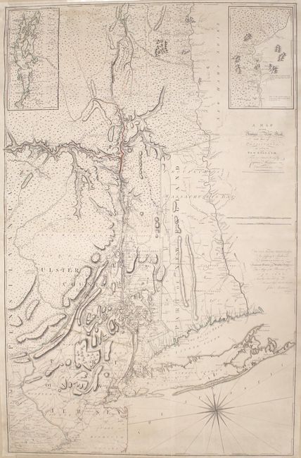
Auction 166, Lot 139
Subject: Colonial New England & Mid-Atlantic United States
Montresor, John
A Map of the Province of New York, with Part of Pensilvania, and New England..., 1775
Size: 36.5 x 56.7 inches (92.7 x 144 cm)
Estimate: $7,000 - $9,000
An Important Revolutionary War Period Map
Sold for: $5,000
Closed on 2/14/2018
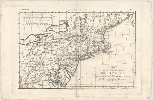
Auction 166, Lot 140
Subject: Colonial New England & Mid-Atlantic United States
Bonne, Rigobert
Carte de la Partie Nord, des Etats Unis, de l'Amerique Septentrionale, 1782
Size: 12.7 x 8.4 inches (32.3 x 21.3 cm)
Estimate: $100 - $130
Sold for: $75
Closed on 2/14/2018
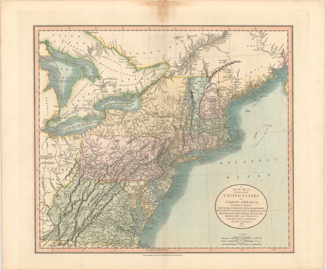
Auction 166, Lot 141
Subject: New England & Mid-Atlantic United States
Cary, John
A New Map of Part of the United States of North America, Containing Those of New York, Vermont, New Hampshire, Massachusets, Connecticut, Rhode Island. Pennsylvania, New Jersey, Delaware, Maryland and Virginia. From the Latest Authorities, 1806
Size: 20.4 x 17.9 inches (51.8 x 45.5 cm)
Estimate: $400 - $500
Sold for: $275
Closed on 2/14/2018
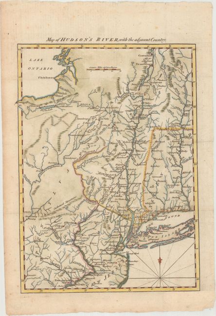
Auction 166, Lot 142
Subject: Colonial New England United States, Revolutionary War
Anon.
Map of Hudson's River, with the Adjacent Country , 1778
Size: 8.5 x 11.6 inches (21.6 x 29.5 cm)
Estimate: $230 - $275
Unsold
Closed on 2/14/2018
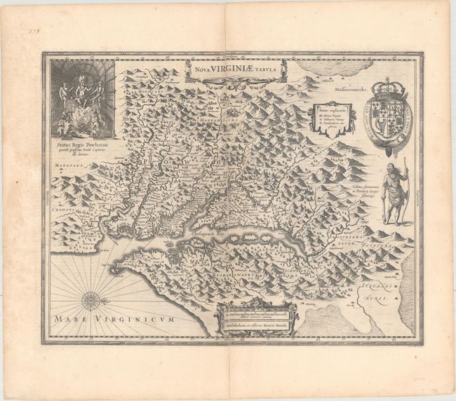
Auction 166, Lot 143
Subject: Colonial Mid-Atlantic United States
Hondius, Henricus
Nova Virginiae Tabula, 1652
Size: 19.4 x 15 inches (49.3 x 38.1 cm)
Estimate: $1,800 - $2,100
One of the Most Important 17th Century Maps of the Chesapeake Bay
Unsold
Closed on 2/14/2018
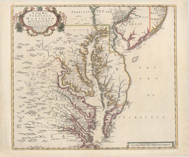
Auction 166, Lot 144
Subject: Colonial Mid-Atlantic United States
Browne/Senex
A New Map of Virginia Mary-land and the Improved Parts of Pennsylvania & New Jersey..., 1719
Size: 21.9 x 19.1 inches (55.6 x 48.5 cm)
Estimate: $4,750 - $6,000
Map of Chesapeake Bay Based on Landmark Herrman Map
Sold for: $3,500
Closed on 2/14/2018
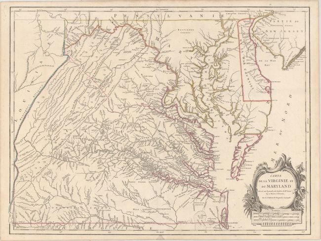
Auction 166, Lot 145
Subject: Colonial Mid-Atlantic United States
Jefferys, Thomas
A Map of Virginia and Maryland, 1756
Size: 7.8 x 5.8 inches (19.8 x 14.7 cm)
Estimate: $275 - $350
Sold for: $500
Closed on 2/14/2018
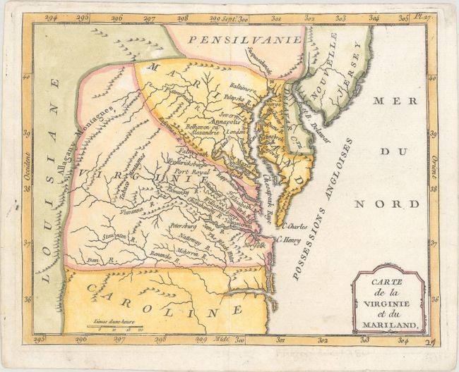
Auction 166, Lot 146
Subject: Colonial Mid-Atlantic United States
Laporte, Joseph de
Carte de la Virginie et du Mariland, 1770
Size: 8.6 x 6.9 inches (21.8 x 17.5 cm)
Estimate: $180 - $220
Sold for: $425
Closed on 2/14/2018
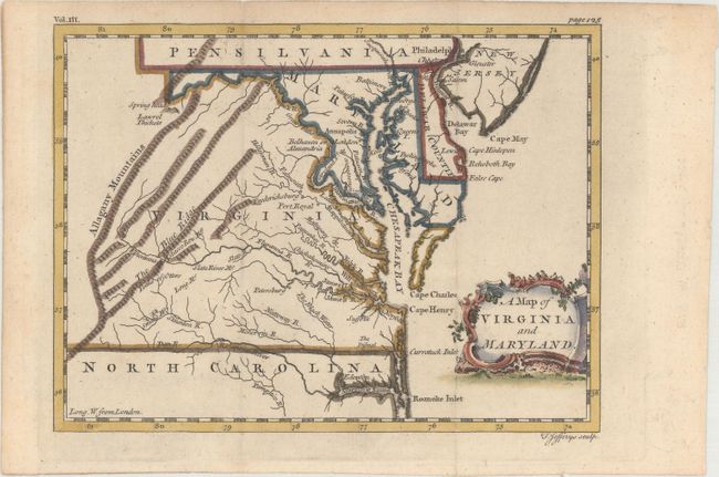
Auction 166, Lot 147
Subject: Mid-Atlantic United States
Robert de Vaugondy, Didier
Carte de la Virginie et du Maryland Dressee sur la Grande Carte Angloise de Mrs. Josue Fry et Pierre Jefferson, 1793
Size: 25.6 x 19.2 inches (65 x 48.8 cm)
Estimate: $2,200 - $2,500
An Essential Map of Virginia and Maryland
Sold for: $1,200
Closed on 2/14/2018
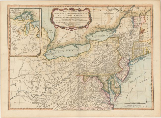
Auction 166, Lot 148
Subject: Mid-Atlantic United States
Laurie & Whittle
A New and General Map of the Middle Dominions Belonging to the United States of America, viz. Virginia, Maryland, the Delaware-Counties, Pennsylvania, New Jersey &c. with the Addition of New York, & of the Greatest Part of New England…, 1794
Size: 26 x 18.8 inches (66 x 47.8 cm)
Estimate: $950 - $1,200
Laurie & Whittle's Popular Map Depicting the "New" United States
Sold for: $550
Closed on 2/14/2018
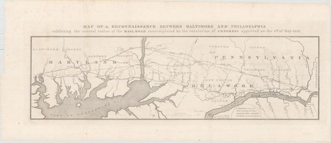
Auction 166, Lot 149
Subject: Mid-Atlantic United States
U.S. Government
Map of a Reconnaissance Between Baltimore and Philadelphia Exhibiting the Several Routes of the Mail Road Contemplated by the Resolution of Congress Approved on the 4th of May 1826, 1828
Size: 31.2 x 9.1 inches (79.2 x 23.1 cm)
Estimate: $140 - $170
Sold for: $400
Closed on 2/14/2018
217 lots
Page 1 of 5