Subject: Eastern United States
Period: 1812 (published)
Publication: Travels in the United States of America
Color: Hand Color
Size:
17.2 x 13.1 inches
43.7 x 33.3 cm
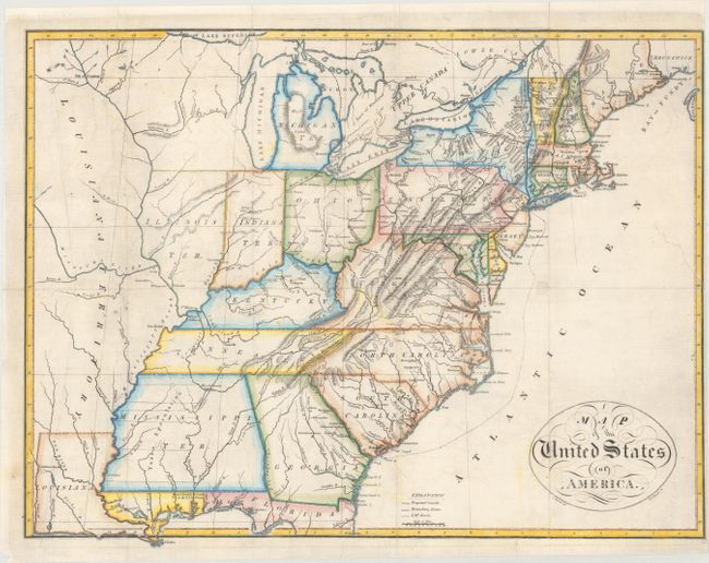
This important map of the early United States by the noted American cartographer John Melish is notable for being the first professional engraving attempt by Henry S. Tanner. It was the frontispiece map to the first edition of the first volume of Melish's Travels in the United States of America, in the years 1806 & 1807, and 1809, 1810 & 1811... The map extends west to include both Louisiana the state and a massive and largely blank Louisiana Territory. The early territories of Michigan, Illinois, and Indiana are noted, with Indiana Territory centered beneath Lake Michigan. There is also an unnamed region that takes in the area that would become Wisconsin and Minnesota. A notation of Yazoo Speculation in the oversized Mississippi Territory refers to the Yazoo Land Fraud perpetrated in 1789-1796 when the region was part of Georgia. Three companies bribed and intimidated a bill through the Georgia assembly that allowed them to purchase millions of acres of land for next to nothing, resulting in a huge public outcry. The bill's supporters were swiftly voted out of power, and Senator James Jackson took office. He vowed to repeal the Yazoo Act if it cost him his life, saying he would repeal it even if he had to shoot everyone involved in passing it. He didn't have to shoot anyone, and the law was rescinded in 1796. The fact it is shown on a map produced many years later attests to the importance attributed to this fraudulent scheme. Good detail throughout the states with towns and villages, Indian place names, roads and trails, forts and watershed. An explanation at bottom identifies proposed canals, boundary lines, and "J.M.'s Route," likely referring to Melish's own travels. The script title appears in a simple border of interlocking chains.
Melish was the first American publisher to concentrate on cartographic and geographic publications. Born in Scotland, Melish emigrated to the United States intent on farming. After traveling some 2,400 miles throughout the northeast looking at land, he finally settled on Philadelphia in 1811. A year later, he published Travels which included his very first maps. He soon came to dominate the industry in this country, and had a huge impact on all subsequent American map-making.
References: Ristow p. 179-80.
Condition: B+
Issued folding, now flat, with a few small fold separations and a 2" inch binding tear at right that have been repaired on verso with archival materials. There is faint offsetting, and the margin is trimmed close at right.