Subject: United States
Period: 1858 (circa)
Publication:
Color: Hand Color
Size:
39.5 x 27.5 inches
100.3 x 69.9 cm
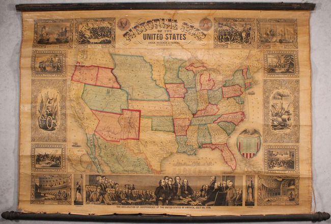
A terrific wall map published at a time when many territorial borders were at their most unique configurations. Utah is a large territory that includes all of Nevada and most of Colorado. New Mexico extends between Texas and California, with Arizona making an appearance along the southern border with Mexico. In California, the Gold Region is prominently depicted. The map was published just prior to Oregon gaining statehood (1859) as there is a new border dividing the old territory in half, yet the eastern side has not yet been adopted by Washington Territory. Nebraska extends from Kansas to the Canadian border and includes today's Montana, Wyoming and much of the Dakotas. Oklahoma is Indian Territory. Dakota is a small area between the Missouri River at the west and the Sioux and Red Rivers on the east, and bounded by Nebraska and Minnesota. There is an extensive railroad network throughout the East, with wagon roads and emigrant routes shown in the western territories. Surrounding the map is a series of 15 vignettes including the signing of the Declaration of Independence, the Landing of Columbus, and the Battle of Bunker Hill. Linen backed with original rollers.
References:
Condition: B
Overall light toning with some small stains in the image and a larger dampstain mostly around the title but extending into the border at top. There is some cracking that is more prominent along the Washington/Oregon border and the "Landing of Columbus" vignette to its left. The bottom roller is nearly detached.