Subject: United States & Canada
Period: 1892 (circa)
Publication: Indian Gallery
Color: Black & White
Size:
14.4 x 8.8 inches
36.6 x 22.4 cm
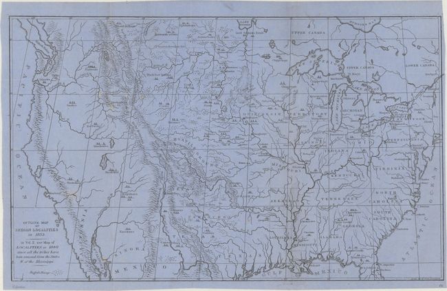
This great map was issued in a later edition of Catlin's Indian Gallery. It names scores of Indian villages, designated by tepee symbols. The map extends well into Canada, locating numerous Canadian tribes. There is good detail of watersheds and the known mountain ranges. The West is mostly blank and contains erroneous information in the Great Basin region derived from Fremont's map, including an east-west flowing river. An Independent Texas is shown with its northern border extending well into the Rocky Mountains, but it is indistinct at its upper reaches. Of special interest is the depiction of the Buffalo Range that stretches throughout the entire plains region and even into Mexico. The entire Midwest north of the Arkansas River and Texas is labeled "Hostile Ground". This later edition is printed on bluish paper but in every other detail matches the 1841 issue.
References:
Condition: B
Printed on bluish paper and issued folding. There are separations along the right fold that have been closed on verso with both archival tape and cello tape, with minor tape stains visible on recto at the top and bottom of the fold. There are a few minor spots of discoloration at left.