Filtered by Category:Canada(Show All Categories)
Showing results for:Auction 166
Catalog Archive
17 lots
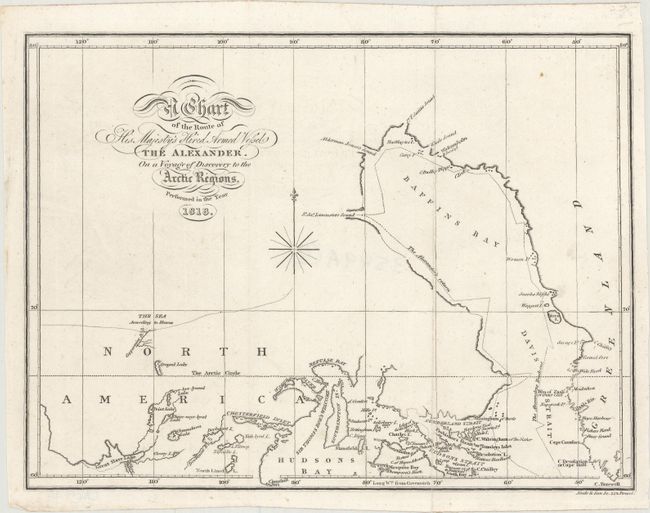
Auction 166, Lot 96
Subject: Northern Canada, Baffin Bay
Parry, William Edward (Adm. Sir)
A Chart of the Route of His Majesty's Hired Armed Vessel the Alexander. On a Voyage of Discovery to the Arctic Regions, 1818
Size: 9.9 x 7.4 inches (25.1 x 18.8 cm)
Estimate: $180 - $210
Unsold
Closed on 2/14/2018
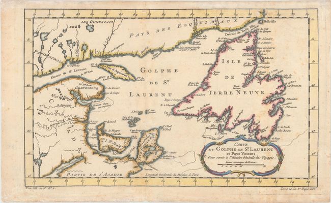
Auction 166, Lot 97
Subject: Eastern Canada
Bellin, Jacques Nicolas
Carte du Golphe de St. Laurent et Pays Voisins pour Servir a l'Histoire Generale des Voyages, 1780
Size: 14.2 x 8.7 inches (36.1 x 22.1 cm)
Estimate: $100 - $130
Sold for: $75
Closed on 2/14/2018
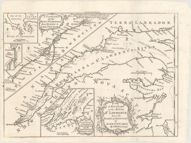
Auction 166, Lot 98
Subject: St. Lawrence River, Canada
Kitchin, Thomas
A New Chart of the River St. Lawrence from the Island of Anticosti to Lake Ontario, 1759
Size: 10 x 7.1 inches (25.4 x 18 cm)
Estimate: $100 - $130
Sold for: $65
Closed on 2/14/2018
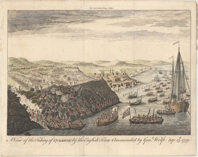
Auction 166, Lot 99
Subject: Quebec City, Canada
Anon.
A View of the Taking of Quebeck by the English Forces Commanded by Genl. Wolfe Sep: 13th. 1759, 1760
Size: 9.8 x 6.7 inches (24.9 x 17 cm)
Estimate: $140 - $170
Sold for: $230
Closed on 2/14/2018
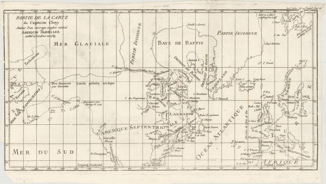
Auction 166, Lot 100
Subject: Colonial United States, Canada & Arctic
Robert de Vaugondy, Didier
Partie de la Carte du Capitaine Cluny Auteur d'un Ouvrage Anglois Intitule American Traveller Publie a Londres en 1769, 1773
Size: 16.1 x 8.4 inches (40.9 x 21.3 cm)
Estimate: $100 - $130
Sold for: $75
Closed on 2/14/2018
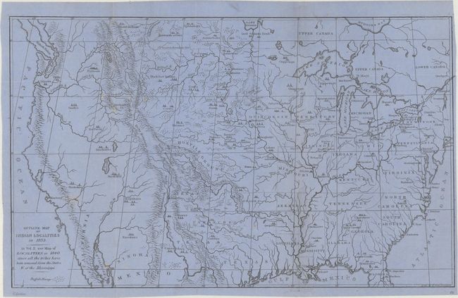
Auction 166, Lot 101
Subject: United States & Canada
Catlin, George
Outline Map of Indian Localities in 1833, 1892
Size: 14.4 x 8.8 inches (36.6 x 22.4 cm)
Estimate: $100 - $130
Sold for: $200
Closed on 2/14/2018
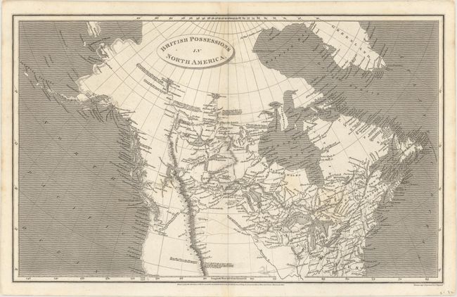
Auction 166, Lot 102
Subject: Northern United States & Canada
Arrowsmith, Aaron, Sr.
British Possessions in North America, 1809
Size: 15.7 x 9.8 inches (39.9 x 24.9 cm)
Estimate: $160 - $200
Sold for: $130
Closed on 2/14/2018
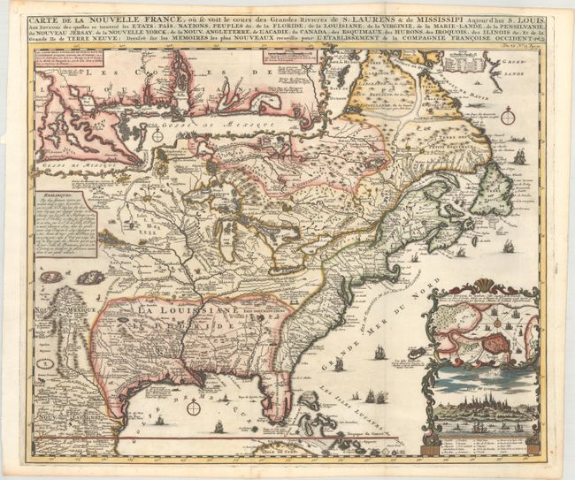
Auction 166, Lot 103
Subject: Colonial Eastern United States & Canada
Chatelain, Henry Abraham
Carte de la Nouvelle France, ou se Voit le Cours des Grandes Rivieres de S. Laurens & de Mississipi Aujour d'hui S. Louis, aux Environs des-quelles se Trouvent les Etats, Pais, Nations, Peuples &c..., 1719
Size: 19.2 x 16.6 inches (48.8 x 42.2 cm)
Estimate: $3,000 - $3,750
One of the Most Informative 18th Century Maps of the French Possessions in North America
Sold for: $3,250
Closed on 2/14/2018
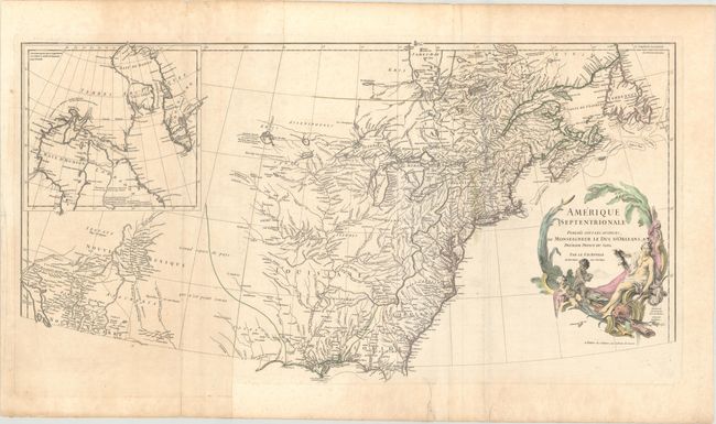
Auction 166, Lot 104
Subject: Colonial Eastern United States & Canada
Anville, Jean Baptiste Bourguignon d'
Amerique Septentrionale Publiee sous les Auspices de Monseigneur de Duc d'Orleans Premier Prince du Sang, 1746
Size: 34.2 x 17.8 inches (86.9 x 45.2 cm)
Estimate: $600 - $750
Sold for: $390
Closed on 2/14/2018
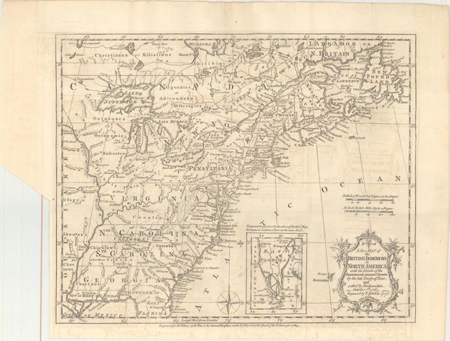
Auction 166, Lot 105
Subject: Colonial Eastern United States & Canada
Kitchin, Thomas
A New Map of the British Dominions in North America; with the Limits of the Governments Annexed Thereto by the Late Treaty of Peace, and Settled by Proclamation, October 7th, 1763, 1763
Size: 11.9 x 9.6 inches (30.2 x 24.4 cm)
Estimate: $350 - $425
Sold for: $275
Closed on 2/14/2018
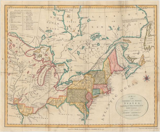
Auction 166, Lot 106
Subject: Eastern United States & Canada
Stockdale, John
A Map of the Northern and Middle States; Comprehending the Western Territory and the British Dominions in North America. From the Best Authorities, 1792
Size: 15.2 x 12.3 inches (38.6 x 31.2 cm)
Estimate: $300 - $375
Sold for: $240
Closed on 2/14/2018
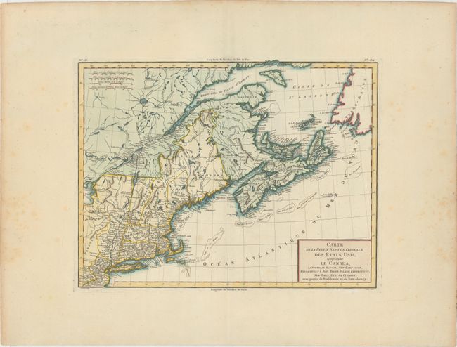
Auction 166, Lot 107
Subject: Eastern United States & Canada
Tardieu, Pierre Francois
Carte de la Partie Septentrionale des Etats Unis, Comprenant le Canada, la Nouvelle Ecosse, New Hampshire, Massachuset's Bay, Rhode-Island, Connecticut, New Yorck, Etat de Vermont avec Partie de Pensilvanie et de New-Jersey, 1797
Size: 16.6 x 12.7 inches (42.2 x 32.3 cm)
Estimate: $275 - $350
Unsold
Closed on 2/14/2018
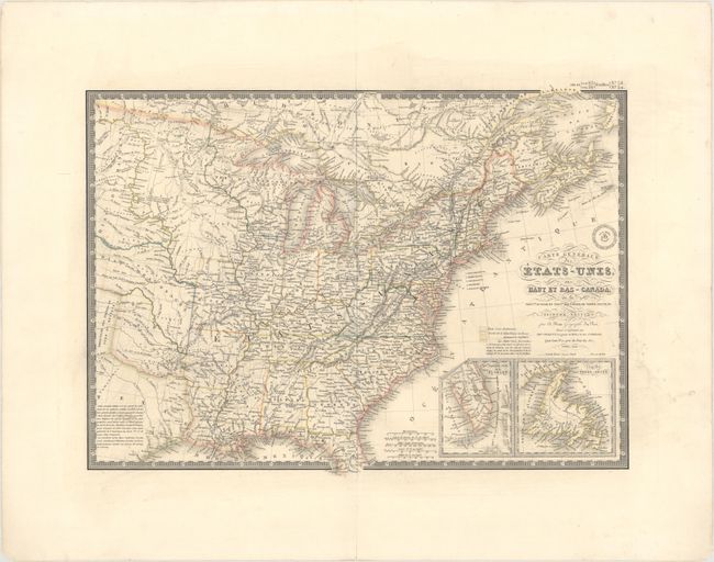
Auction 166, Lot 108
Subject: Eastern United States & Canada
Brue, Adrien Hubert
Carte Generale des Etats-Unis, des Haut et Bas-Canada, de la Nouvle. Ecosse, du Nouvau Brunswick, de Terre-Neuve, &a. Seconde Edition, 1840
Size: 20.3 x 14.6 inches (51.6 x 37.1 cm)
Estimate: $180 - $210
Unsold
Closed on 2/14/2018
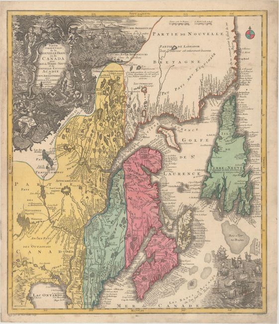
Auction 166, Lot 109
Subject: Colonial New England & Canada
Seutter/Lotter
Partie Orientale de la Nouvelle France ou du Canada avec l'Isle de Terre-Neuve et de Nouvelle Escosse, Acadie et Nouv. Angleterre..., 1740
Size: 19.4 x 22.6 inches (49.3 x 57.4 cm)
Estimate: $900 - $1,100
Sold for: $650
Closed on 2/14/2018
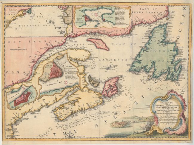
Auction 166, Lot 110
Subject: Colonial New England & Canada
Jefferys, Thomas
A New Chart of the Coast of New England, Nova Scotia New France or Canada, with the Islands of Newfoundld. Cape Breton St. John's &c. Done from the Original Publish'd in 1744..., 1746
Size: 18 x 13.2 inches (45.7 x 33.5 cm)
Estimate: $275 - $350
Sold for: $275
Closed on 2/14/2018
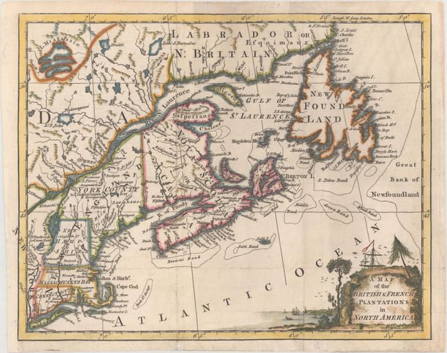
Auction 166, Lot 111
Subject: Colonial New England & Canada
Anon.
A Map of the British & French Plantations in North America, 1755
Size: 10.5 x 8.2 inches (26.7 x 20.8 cm)
Estimate: $240 - $300
Sold for: $140
Closed on 2/14/2018
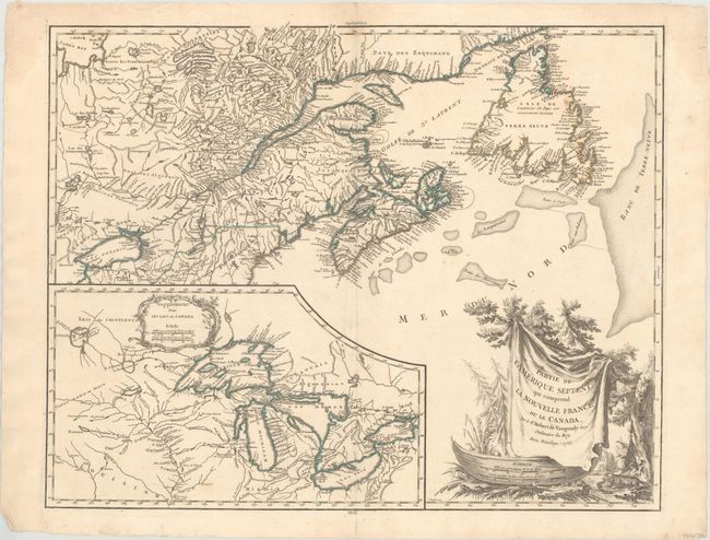
Auction 166, Lot 112
Subject: Colonial Northeastern United States & Canada, Great Lakes
Robert de Vaugondy, Didier
Partie de l'Amerique Septent? qui Comprend la Nouvelle France ou le Canada, 1755
Size: 23.9 x 19 inches (60.7 x 48.3 cm)
Estimate: $600 - $750
Unsold
Closed on 2/14/2018
17 lots