Filtered by Category:United States(Show All Categories)
Showing results for:Auction 164
Catalog Archive
257 lots
Page 1 of 6
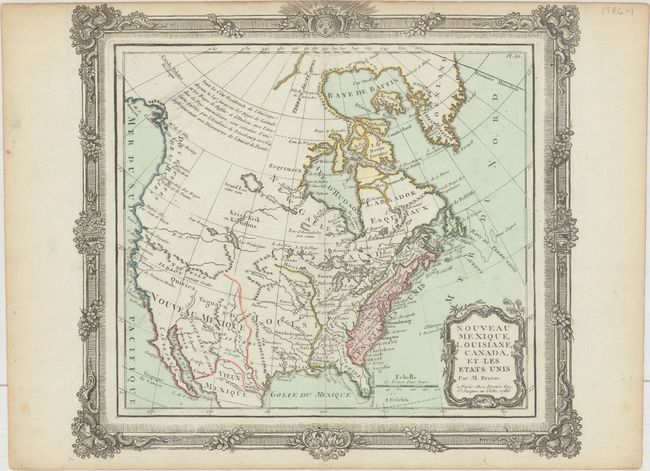
Auction 164, Lot 103
Subject: United States & Canada
Brion de la Tour/Desnos
Nouveau Mexique, Louisiane, Canada, et les Etats Unis, 1786
Size: 12.4 x 11.3 inches (31.5 x 28.7 cm)
Estimate: $190 - $220
Sold for: $140
Closed on 9/13/2017
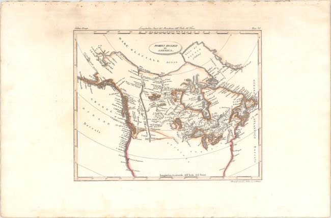
Auction 164, Lot 104
Subject: United States & Canada
Rossi, Luigi
Dominj Inglesi in America, 1820
Size: 9.8 x 7.8 inches (24.9 x 19.8 cm)
Estimate: $150 - $180
Unsold
Closed on 9/13/2017
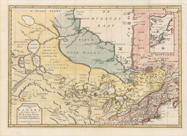
Auction 164, Lot 105
Subject: Colonial Northern United States & Canada
Tirion, Isaac
Nieuwe Kaart van Kanada, de Landen aan de Hudsons-Baay en de Noordwestelyke deelen van Noord-Amerika, 1769
Size: 17.4 x 12.3 inches (44.2 x 31.2 cm)
Estimate: $275 - $350
Sold for: $200
Closed on 9/13/2017
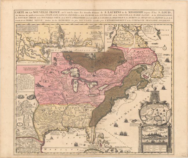
Auction 164, Lot 106
Subject: Colonial Eastern United States & Canada
Fer, Nicolas de
Carte de la Nouvelle France, ou se voit le Cours des Grandes Rivieres de S. Laurens & de Mississipi Aujour d'hui S. Louis, aux Environs Des-quelles se Trouvent les Etats, Pais, Nations, Peuples &c..., 1719
Size: 21.6 x 19.7 inches (54.9 x 50 cm)
Estimate: $1,700 - $2,000
Striking Map of French Colonial Possessions
Sold for: $900
Closed on 9/13/2017
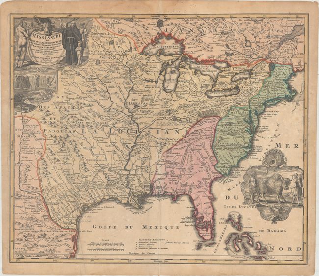
Auction 164, Lot 107
Subject: Colonial Eastern United States & Canada
Homann, Johann Baptist
Amplissimae Regionis Mississipi seu Provinciae Ludovicinae..., 1720
Size: 22.8 x 19.3 inches (57.9 x 49 cm)
Estimate: $1,600 - $1,900
Striking Map of Colonial America with Buffalo Vignette
Sold for: $800
Closed on 9/13/2017
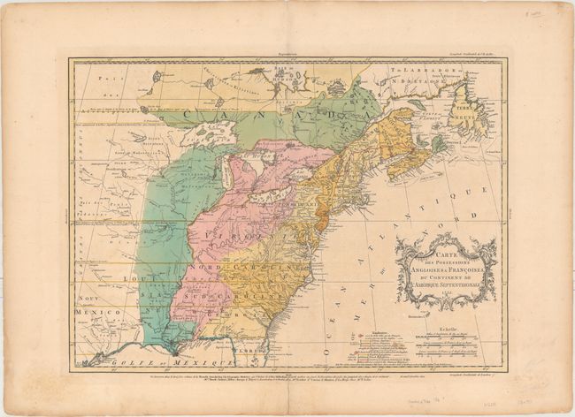
Auction 164, Lot 108
Subject: Colonial Eastern United States & Canada
Palairet, Jean
Carte des Possessions Angloises & Francoises du Continent de l'Amerique Septentrionale, 1755
Size: 22.7 x 16.4 inches (57.7 x 41.7 cm)
Estimate: $2,300 - $2,750
Important Map of French and English Territorial Claims at the Outset of the French and Indian War
Sold for: $1,600
Closed on 9/13/2017
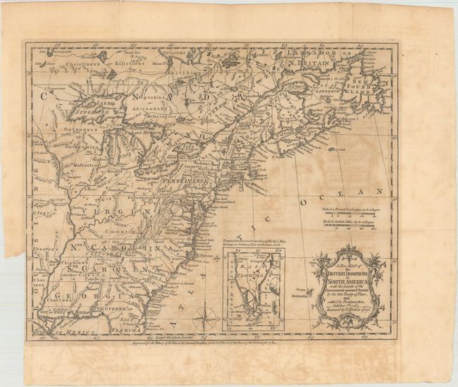
Auction 164, Lot 109
Subject: Colonial Eastern United States & Canada
Kitchin, Thomas
A New Map of the British Dominions in North America; with the Limits of the Governments Annexed Thereto by the Late Treaty of Peace, and Settled by Proclamation, October 7th 1763, 1763
Size: 11.9 x 9.6 inches (30.2 x 24.4 cm)
Estimate: $325 - $400
Sold for: $240
Closed on 9/13/2017
Auction 164, Lot 110
Subject: Colonial Eastern United States & Canada
Bonne/Lattre
[On 2 Sheets] Partie de l'Amerique Septentrionale, qui Comprend le Canada, la Louisiane, le Labrador, le Groenland, la Nouvelle Angleterre, la Floride &c. Projettee et Assujettie aux Observations, 1771
Size: 17.2 x 11.8 inches (43.7 x 30 cm)
Estimate: $450 - $550
Sold for: $275
Closed on 9/13/2017
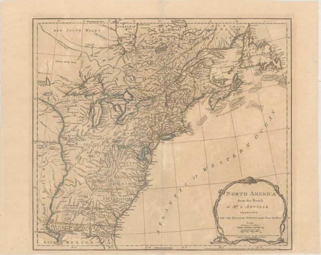
Auction 164, Lot 111
Subject: Colonial Eastern United States & Canada
Jefferys/Sayer & Bennett
North America from the French of Mr. d'Anville Improved with the English Surveys Made Since the Peace, 1775
Size: 20.3 x 18.2 inches (51.6 x 46.2 cm)
Estimate: $550 - $700
Sold for: $300
Closed on 9/13/2017
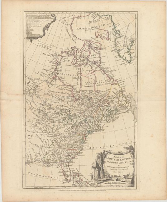
Auction 164, Lot 112
Subject: Colonial Eastern United States & Canada
Dunn, Samuel
A Map of the British Empire, in North America, 1776
Size: 12.1 x 18.8 inches (30.7 x 47.8 cm)
Estimate: $1,100 - $1,400
Unsold
Closed on 9/13/2017
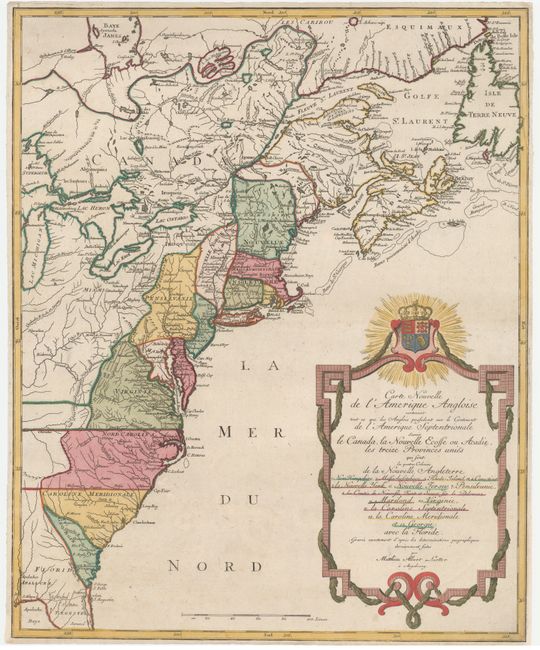
Auction 164, Lot 113
Subject: Colonial Eastern United States & Canada
Lotter, Mathias Albrecht
Carte Nouvelle de l'Amerique Angloise Contenant tout ce que les Anglois Possedent sur le Continent de l'Amerique Septentrionale Savoir le Canada..., 1776
Size: 19.4 x 23.7 inches (49.3 x 60.2 cm)
Estimate: $1,200 - $1,500
Sold for: $800
Closed on 9/13/2017
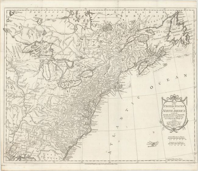
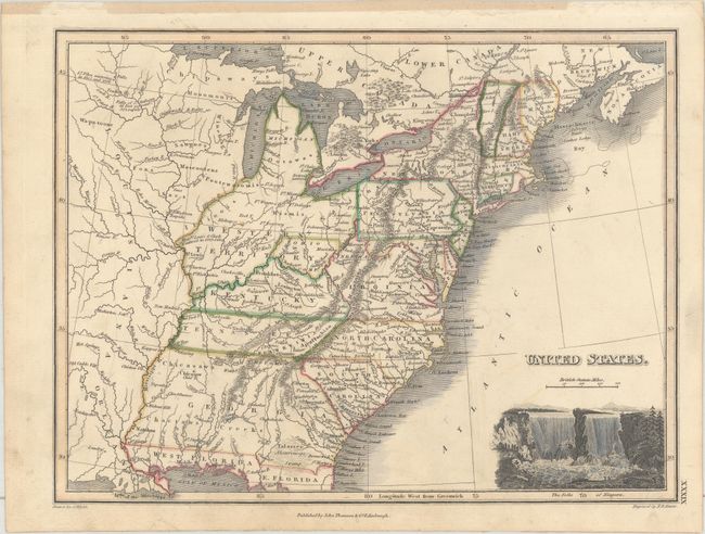
Auction 164, Lot 114
Subject: Eastern United States & Canada
Kitchin, Thomas
Map of the United States in North America: with the British, French and Spanish Dominions Adjoining, According to the Treaty of 1783, 1783
Size: 20.1 x 16.2 inches (51.1 x 41.1 cm)
Estimate: $1,000 - $1,300
One of the Earliest English-Produced Maps to Acknowledge the United States
Sold for: $750
Closed on 9/13/2017
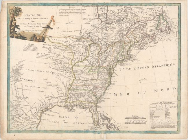
Auction 164, Lot 115
Subject: Eastern United States & Canada
Delamarche, Charles Francois
Etats-Unis de l'Amerique Septentrionale avec les Isles Royale, de Terre Neuve, de St. Jean, l'Acadie &c., 1785
Size: 24.8 x 18.8 inches (63 x 47.8 cm)
Estimate: $900 - $1,100
First Reference to Michigan as a Land Division of the United States
Sold for: $600
Closed on 9/13/2017
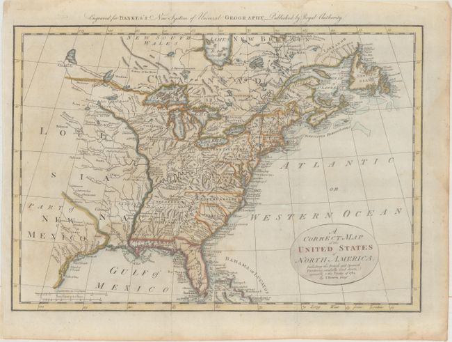
Auction 164, Lot 116
Subject: Eastern United States & Canada
Bowen, Thomas
A Correct Map of the United States of North America. Including the British and Spanish Territories, Carefully Laid Down Agreeable to the Treaty of 1784, 1787
Size: 17.6 x 12.4 inches (44.7 x 31.5 cm)
Estimate: $350 - $450
Sold for: $450
Closed on 9/13/2017
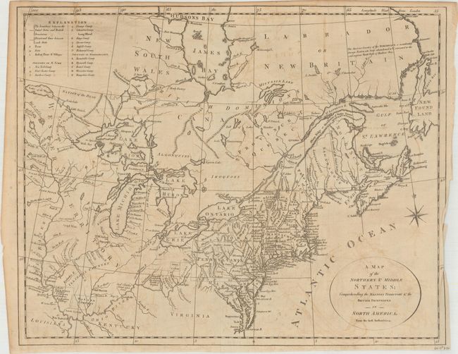
Auction 164, Lot 117
Subject: Eastern United States & Canada
Stockdale, John
A Map of the Northern and Middle States; Comprehending the Western Territory and the British Dominions in North America. From the Best Authorities, 1792
Size: 15.7 x 12.5 inches (39.9 x 31.8 cm)
Estimate: $500 - $650
Sold for: $150
Closed on 9/13/2017
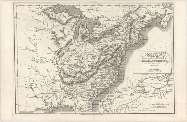
Auction 164, Lot 118
Subject: Eastern United States & Canada
Baines, Edward
United States of America Exhibiting the Seat of War on the Canadian Frontier. From 1812. to 1815, 1816
Size: 13.6 x 9.5 inches (34.5 x 24.1 cm)
Estimate: $350 - $425
Unsold
Closed on 9/13/2017
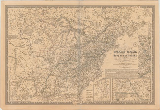
Auction 164, Lot 119
Subject: Eastern United States & Canada
Brue, Adrien Hubert
Nouvelle Carte des Etats-Unis, des Haut et Bas-Canada, de la Nouvle.-Ecosse, du Nouvau Brunswick, de Terre-Neuve &a..., 1836
Size: 36.5 x 24.8 inches (92.7 x 63 cm)
Estimate: $500 - $600
Sold for: $300
Closed on 9/13/2017
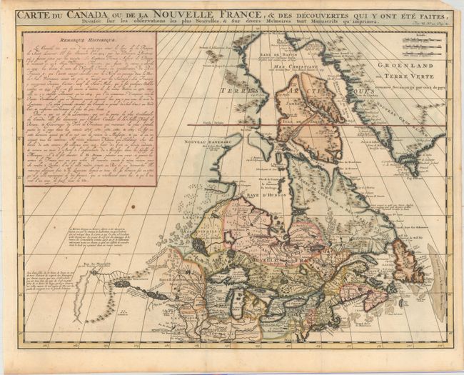
Auction 164, Lot 120
Subject: Colonial Northeastern United States & Canada
Chatelain, Henry Abraham
Carte du Canada ou de la Nouvelle France, & des Decouvertes qui y ont ete Faites, Dressee sur les Observations les Plus Nouvelles, & sur Divers Memoires tant Manuscrits qu' Imprimez, 1719
Size: 20.5 x 16.1 inches (52.1 x 40.9 cm)
Estimate: $600 - $750
Sold for: $350
Closed on 9/13/2017
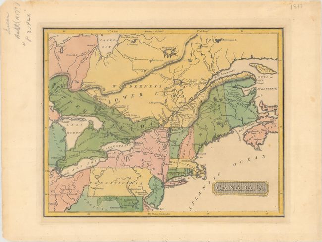
Auction 164, Lot 121
Subject: Northeastern United States & Canada
Lucas, Fielding
Canada, &c., 1816
Size: 10.6 x 8.4 inches (26.9 x 21.3 cm)
Estimate: $250 - $325
Unsold
Closed on 9/13/2017
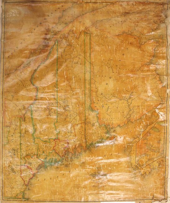
Auction 164, Lot 122
Subject: Maine, Eastern Canada
Greenleaf, Moses
[Wall Map] Map of the State of Maine with the Province of New Brunswick, 1832
Size: 41 x 49.2 inches (104.1 x 125 cm)
Estimate: $1,400 - $1,700
Second Edition of Greenleaf's Large Map of Maine
Sold for: $950
Closed on 9/13/2017
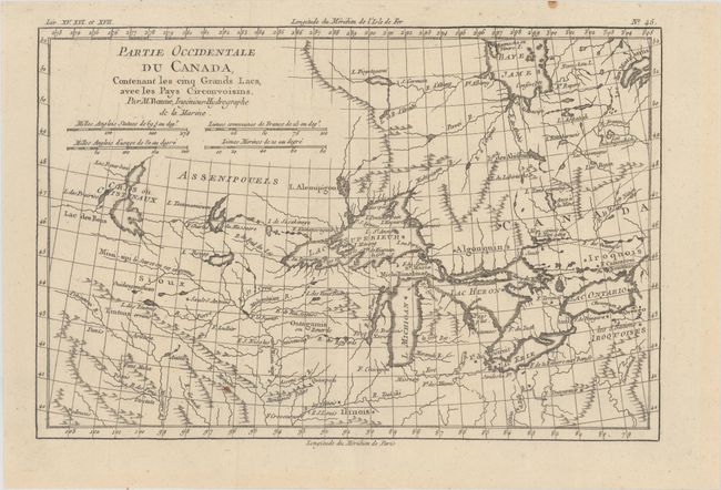
Auction 164, Lot 123
Subject: Great Lakes
Bonne, Rigobert
Partie Occidentale du Canada, Contenant les Cinq Grands Lacs, avec les Pays Circonvoisins, 1775
Size: 12.6 x 8.4 inches (32 x 21.3 cm)
Estimate: $220 - $250
Sold for: $130
Closed on 9/13/2017
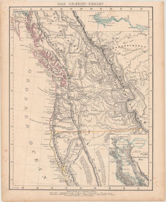
Auction 164, Lot 124
Subject: Western United States & Canada
Flemming, Carl
Das Oregon-Gebiet, 1848
Size: 12.6 x 16.1 inches (32 x 40.9 cm)
Estimate: $220 - $250
Sold for: $160
Closed on 9/13/2017
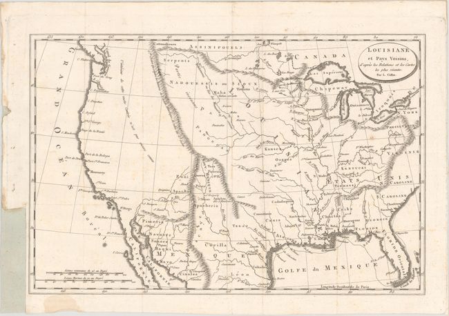
Auction 164, Lot 125
Subject: United States
Baudry des Lozieres, Louis Narciss
Louisiane et Pays Voisins, d'Apres les Relations et les Cartes les Plus Recentes, 1802
Size: 14.2 x 9.4 inches (36.1 x 23.9 cm)
Estimate: $475 - $600
Unsold
Closed on 9/13/2017
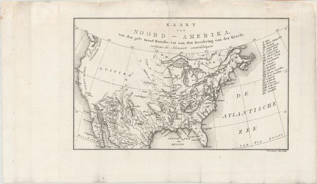
Auction 164, Lot 126
Subject: United States, Franklin
Zimmerman, Eberhard A.W.
Kaart van Noord-Amerika, van den 50ften Graad Breedte tot aan den Keerkring van den Kreeft, Volgens de Nieuwste Ontdekkingen, 1818
Size: 10.6 x 6.5 inches (26.9 x 16.5 cm)
Estimate: $200 - $240
Rare Map Showing the State of Franklin
Sold for: $250
Closed on 9/13/2017
Auction 164, Lot 127
Subject: United States
Hinton, Simpkin & Marshall
Map of the United States of America. And Nova Scotia, &c.&c., 1832
Size: 15.4 x 9.9 inches (39.1 x 25.1 cm)
Estimate: $180 - $210
Sold for: $120
Closed on 9/13/2017
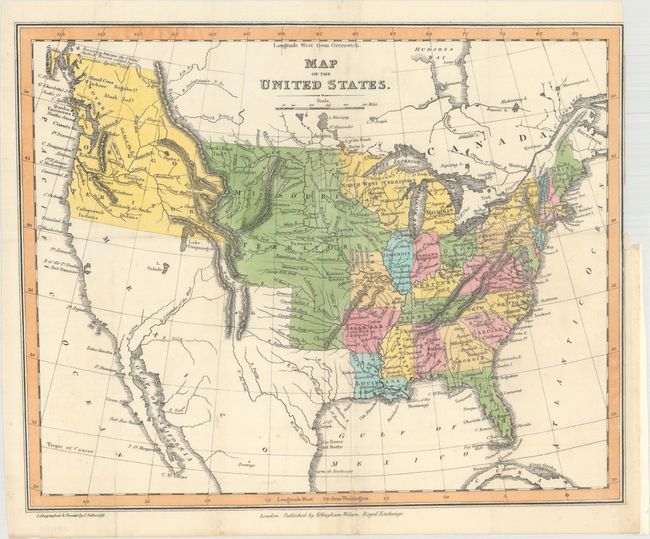
Auction 164, Lot 128
Subject: United States
Map of the United States, 1833
Size: 14.3 x 11.6 inches (36.3 x 29.5 cm)
Estimate: $200 - $230
Sold for: $550
Closed on 9/13/2017
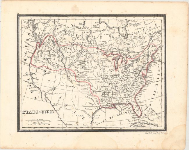
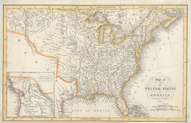
Auction 164, Lot 129
Subject: United States
Etats-Unis, 1840
Size: 10 x 7.8 inches (25.4 x 19.8 cm)
Estimate: $120 - $150
Unsold
Closed on 9/13/2017
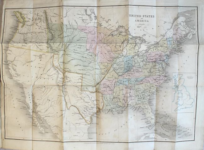
Auction 164, Lot 130
Subject: United States, Texas
Wyld, James
[Map in Book] United States of America [in] American Facts. Notes and Statistics..., 1845
Size: 21.4 x 14.8 inches (54.4 x 37.6 cm)
Estimate: $500 - $650
Sold for: $500
Closed on 9/13/2017
Auction 164, Lot 131
Subject: United States, Texas
Gilman, E.
[Untitled - United States], 1848
Size: 33.4 x 13.9 inches (84.8 x 35.3 cm)
Estimate: $500 - $650
Sold for: $275
Closed on 9/13/2017
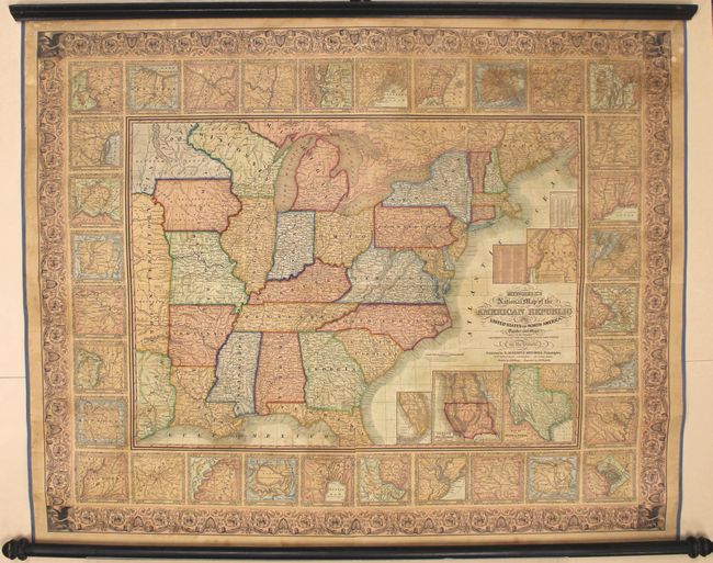
Auction 164, Lot 132
Subject: United States
Mitchell, Samuel Augustus
[Wall Map] Mitchell's National Map of the American Republic or United States of North America, 1849
Size: 47 x 38 inches (119.4 x 96.5 cm)
Estimate: $1,000 - $1,300
Sold for: $1,400
Closed on 9/13/2017
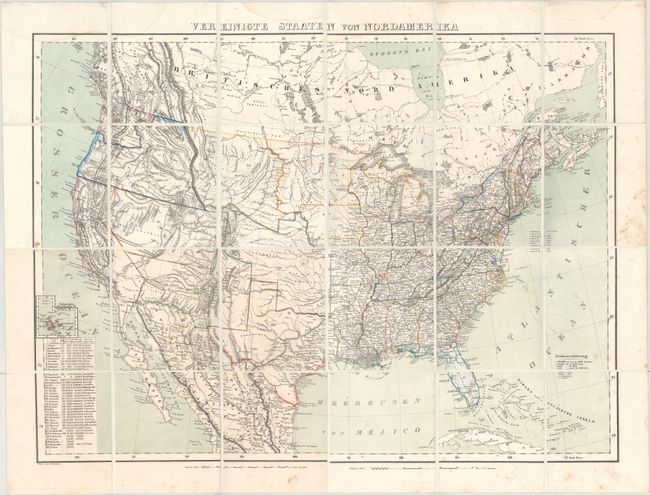
Auction 164, Lot 133
Subject: United States
Flemming, Carl
Vereinigte Staaten von Nordamerika, 1853
Size: 28.1 x 20.8 inches (71.4 x 52.8 cm)
Estimate: $350 - $425
Sold for: $210
Closed on 9/13/2017
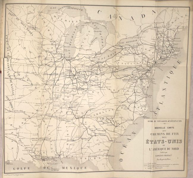
Auction 164, Lot 134
Subject: United States
Guide-Chaix - Bibliotheque du Voyageur - Nouveau Guide du Voyageur et du Touriste aux Etats-Unis avec Gravures et Carte des Chemins de Fer Americains, 1855
Size: 4.4 x 6.9 inches (11.2 x 17.5 cm)
Estimate: $275 - $350
Unsold
Closed on 9/13/2017
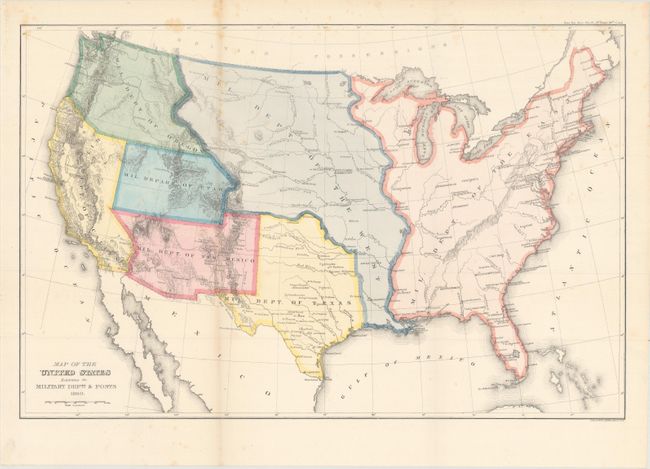
Auction 164, Lot 135
Subject: United States
U.S. Government
Map of the United States Exhibiting the Military Depts. & Posts, 1860
Size: 19.7 x 13 inches (50 x 33 cm)
Estimate: $300 - $375
Unsold
Closed on 9/13/2017
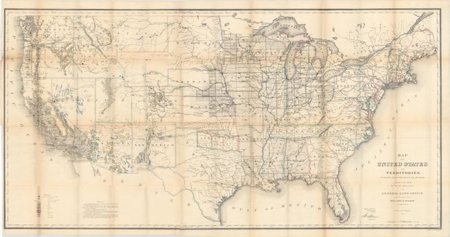
Auction 164, Lot 136
Subject: United States
General Land Office
Map of the United States and Territories. Shewing the Extent of Public Surveys and Other Details..., 1866
Size: 55.4 x 28.2 inches (140.7 x 71.6 cm)
Estimate: $250 - $325
Sold for: $150
Closed on 9/13/2017
Auction 164, Lot 137
Subject: United States
Johnston, Keith
United States of North America (Western States) [and] United States of Norh America (Eastern States), 1870
Size: 23 x 18.2 inches (58.4 x 46.2 cm)
Estimate: $160 - $200
Sold for: $100
Closed on 9/13/2017
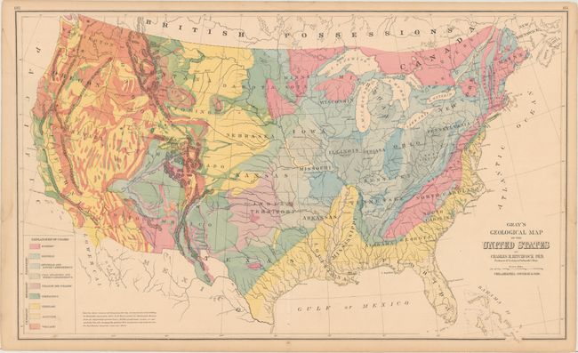
Auction 164, Lot 138
Subject: United States
Gray, Ormando Willis & Son
Gray's Geological Map of the United States, 1881
Size: 26.8 x 16.3 inches (68.1 x 41.4 cm)
Estimate: $120 - $150
Sold for: $90
Closed on 9/13/2017
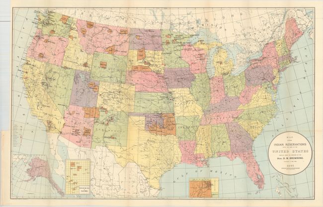
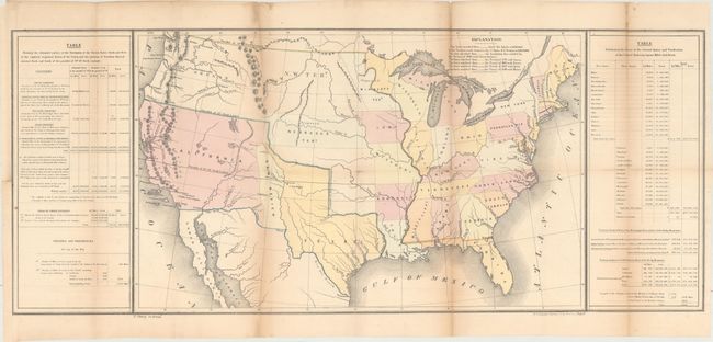
Auction 164, Lot 139
Subject: United States
U.S. Bureau of Indian Affairs
Map Showing Indian Reservations Within the Limits of the United States..., 1895
Size: 33.3 x 21.1 inches (84.6 x 53.6 cm)
Estimate: $140 - $170
Sold for: $100
Closed on 9/13/2017
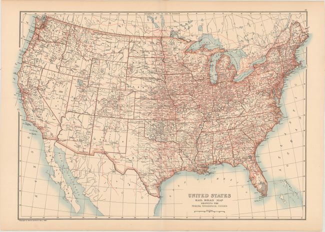
Auction 164, Lot 140
Subject: United States
Black, Adam & Charles
United States Rail Road Map Showing the Principal Topographical Features, 1896
Size: 23.1 x 16.1 inches (58.7 x 40.9 cm)
Estimate: $100 - $130
Unsold
Closed on 9/13/2017
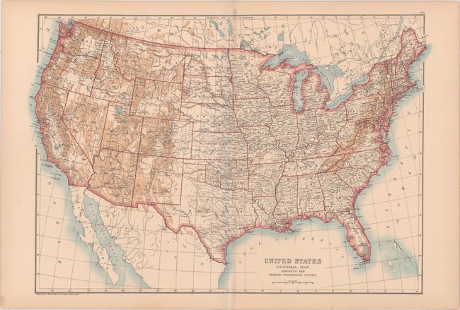
Auction 164, Lot 141
Subject: United States
Black, Adam & Charles
United States General Map Showing the Principal Topographical Features, 1896
Size: 23.3 x 16.1 inches (59.2 x 40.9 cm)
Estimate: $100 - $130
Unsold
Closed on 9/13/2017
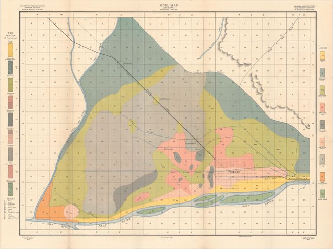
Auction 164, Lot 142
Subject: United States
U.S.D.A.
[Lot of 55 - U.S.D.A. Soil Maps], 1900-01
Size: 6 x 9.5 inches (15.2 x 24.1 cm)
Estimate: $300 - $375
Features Maps of Southern California, Phoenix, and Boise
Sold for: $150
Closed on 9/13/2017
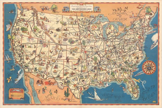
Auction 164, Lot 143
Subject: United States
A Good-Natured Map of the United States Setting Forth the Services of the Greyhound Lines and a Few Principal Connecting Bus Lines, 1940
Size: 29 x 19.1 inches (73.7 x 48.5 cm)
Estimate: $250 - $325
Sold for: $210
Closed on 9/13/2017
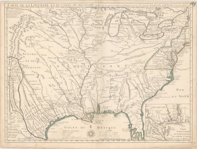
Auction 164, Lot 144
Subject: Colonial Eastern United States
Delisle, Guillaume
Carte de la Louisiane et du Cours du Mississipi Dressee sur un Grand Nombre de Memoires Entrautres sur ceux de Mr. le Maire, 1718
Size: 25.3 x 19.1 inches (64.3 x 48.5 cm)
Estimate: $8,000 - $9,500
A Foundation Map for the Mississippi Valley and the First Appearance of Texas on a Printed Map
Unsold
Closed on 9/13/2017
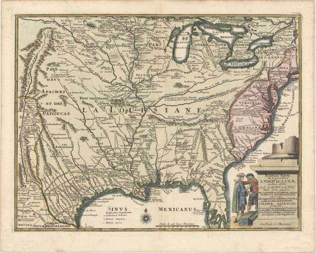
Auction 164, Lot 145
Subject: Colonial Eastern United States
Weigel, Christopher
Novissima Tabula Regionis Ludovicianae Gallice Dictae la Louisiane tam olim Quidem sub Canadae et Floridae Nomine in America Septentrionali..., 1734
Size: 16.5 x 12.5 inches (41.9 x 31.8 cm)
Estimate: $1,400 - $1,700
Uncommon Map of French Louisiana with a Title Cartouche Referencing the Mississippi Bubble Scheme
Sold for: $700
Closed on 9/13/2017
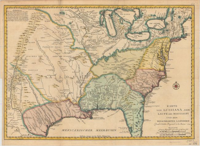
Auction 164, Lot 146
Subject: Colonial Eastern United States
Bellin, Jacques Nicolas
Karte von Luisiana, dem Laufe des Mississipi und den Benachbarten Laendern…, 1744
Size: 22 x 15.5 inches (55.9 x 39.4 cm)
Estimate: $900 - $1,100
Unsold
Closed on 9/13/2017
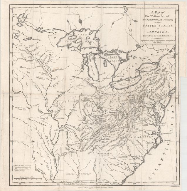
Auction 164, Lot 147
Subject: Eastern United States
Conder, Thomas
A Map of the Western Part of the Territories Belonging to the United States of America. Drawn from the Best Authorities, 1793
Size: 13.1 x 13.9 inches (33.3 x 35.3 cm)
Estimate: $475 - $600
Sold for: $250
Closed on 9/13/2017
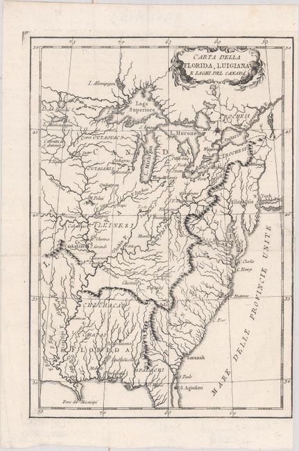
Auction 164, Lot 148
Subject: Eastern United States
Anon.
Carta della Florida, Luigiana e Laghi del Canada, 1800
Size: 6.8 x 9.8 inches (17.3 x 24.9 cm)
Estimate: $240 - $300
Unsold
Closed on 9/13/2017
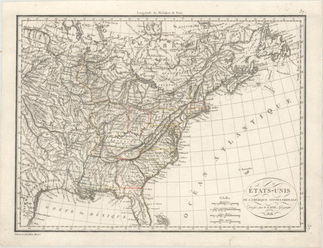
Auction 164, Lot 149
Subject: Eastern United States
[Lot of 2] Etats-Unis de l'Amerique Septentrionale [and] Carte des Etats-Unis d'Amerique, 1816-36
Size: See Description
Estimate: $220 - $250
Sold for: $140
Closed on 9/13/2017
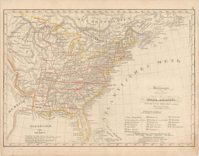
Auction 164, Lot 150
Subject: Eastern United States
Mollo, Tranquillo
Vereinigte Staaten in Nord America nach den Besten Hulfsmittel Verfast, 1817
Size: 17.6 x 12.6 inches (44.7 x 32 cm)
Estimate: $350 - $425
Sold for: $250
Closed on 9/13/2017
Auction 164, Lot 151
Subject: Eastern United States
Wyld, James
United States, 1822
Size: 11.5 x 8.8 inches (29.2 x 22.4 cm)
Estimate: $400 - $500
Depicts the State of Franklin
Sold for: $375
Closed on 9/13/2017
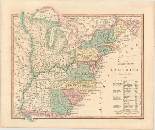
Auction 164, Lot 152
Subject: Eastern United States, Franklinia
Hamilton, Adams & Company
The United States of America Confirmed by Treaty. 1783, 1831
Size: 11.1 x 9.8 inches (28.2 x 24.9 cm)
Estimate: $700 - $850
Map of the United States Featuring Franklinia and the Indiana Land Company
Sold for: $550
Closed on 9/13/2017
257 lots
Page 1 of 6