Subject: Colonial Northern United States & Canada
Period: 1769 (dated)
Publication: Nieuwe en Beknopte Hand-Atlas
Color: Hand Color
Size:
17.4 x 12.3 inches
44.2 x 31.2 cm
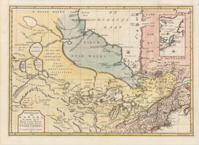
This attractive and detailed map is based on Jefferys' important map of Canada in 1760. It covers from Hudson Bay, through the Great Lakes, to Philadelphia and west to include Lake Winnipeg. There is an interesting array of speculative cartography in the lakes and rivers. While there is a realistic interpretation of Lake Winnipeg, it connects via the Rivier Bourbon to Hudson Bay, and also gives rise to the Mississippi River. The St. Charles River, which connects with the Mississippi, flows off the map to the west with a notation in Dutch, "the length of which is unknown, this is the route the Indians follow coming from the West." Several Hudson Bay Company forts and numerous Indian villages are located. An inset illustrates the Gulf of St. Lawrence.
References: Kershaw #375; McCorkle #769.2; Shirley (BL Atlases) T.TIR-2a.
Condition: A
A crisp impression on a clean, bright sheet, issued folding and now flattened with a hint of offsetting and a binding trim at right that has been replaced with period-correct paper.