Subject: Colonial Eastern United States & Canada
Period: 1755 (dated)
Publication: Atlas Methodique...
Color: Hand Color
Size:
22.7 x 16.4 inches
57.7 x 41.7 cm
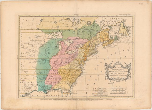
This fascinating map is one of the best maps of the colonies at the outset of the French and Indian War. Mr. Palairet was the Agent to the States-General in London. In 1755 he published his map with a pamphlet "A Concise Description of the English and French Possessions in North-America" and in atlas format the same year, distributed in London, Amsterdam, Berlin and The Hague. The map was beautifully engraved by Thomas Kitchen and intricately colored to show the disputed lands, forts, roads, and the extent of settlement in the region. The original coloring shows the British colonies in yellow, the French colonies in green, the Countries in dispute in pink, and the chain of forts being built by the French to encircle the British colonies highlighted in red. This is an unrecorded state, although most similar to the second state with the Explication in both French and English but without Palairet's name in the cartouche, and still dated 1755. However this state includes Sayer's name in the list of publishers that appears below the map.
This map was based on John Mitchell's index of his large, epic map of the region, A Map of the British Colonies in North America published in 1755. Geographically, the map depicts the borders of the colonies extending well past the Mississippi River to the western reaches of the map. The Great Lakes are beautifully illustrated with Lake Superior still sporting the imaginary island of Philippeaux, and the area of present-day Texas is named Nouv: Mexico, with several roads and a handful of towns, including Cenis. One of the most interesting features on this edition is the red line that appears between Bay Vert, Nova Scotia, and Oswego on Lake Ontario. This line represents the extent of French claims into British territory as a result of French victories in the first 2 years of the French and Indian War, thus putting the publication date of this map around 1757-58.
The fact that this map includes elements in both French and English indicates that it was intended for wider distribution throughout Europe. Palairet was born in France but fled to England where he became a French tutor to King George II’s children. Perhaps as a result of his heritage, Palairet uses a neutral tone in both his Atlas Methodique and on this map, describing French advances as "claims" or "disputed lands" rather than as "encroachments," as one would typically find on English maps of the time period. A fascinating maps that illustrates the competing interests at the beginning of the French and Indian War.
References: McCorkle #755.22; Sellers and Van Ee #56; Shirley (BL Atlases) T.PAL-1a #14; Tooley (America), p. 62 #18-b.
Condition: B+
Full original color on paper with a large fleur-de-lis watermark and wide margins. There is light soiling, minor toning, and an archivally repaired centerfold separation that just enters the map border at bottom.