Subject: Colonial Eastern United States & Canada
Period: 1775 (dated)
Publication: The American Atlas
Color: Hand Color
Size:
20.3 x 18.2 inches
51.6 x 46.2 cm
Thomas Jefferys was one of the most important English map publishers of the 18th century. His work included prints and maps of locations around the world, but his most notable maps are of North America and the West Indies. He began his career in the map trade in the early 1730s, working as an engraver for a variety of London publishers, and eventually setting up his own shop. In 1746, he was appointed Geographer to the Prince of Wales, and in 1760 he became Geographer to the King. These titles granted access to manuscripts and cartographic information held by the government. In the early 1760s he embarked on an ambitious project to produce a series of English county maps based on new surveys, but ran out of money and filed for bankruptcy in 1766. He then partnered with London publisher Robert Sayer, who reissued many of Jefferys plates and continued to issue new editions after Jefferys' death in 1771. Jefferys' American Atlas and the accompanying West-India Atlas, published post posthumously, are considered his most important cartographic works.
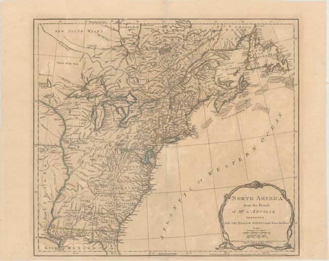
This is the third state of this important map detailing the British colonies after the conclusion of the French and Indian War and on the eve of the Revolutionary War. The map is extremely detailed with the locations of forts, Indian villages, tribal territory, and mines. A note in the title cartouche states, "The boundaries of the Provinces since the conquest of Canada are laid down as settled by the King in Council." Although the colonial claims are shown extending to the Mississippi River, the boundaries of the colonies only extend to the Appalachian Mountains. Main is named, and New Hampshire encompasses all of Vermont. In the south, Florida is divided into East and West. Sayer & Bennett's imprint appears at bottom right.
References: McCorkle #775.2; Stevens & Tree #51c; Sellers and Van Ee #30.
Condition: B
Original outline color on paper with a large fleur-de-lis coat of arms watermark, moderate toning, and light soiling. There are several creases along the edges of the sheet.