Filtered by Category:Canada(Show All Categories)
Current Auction
23 lots
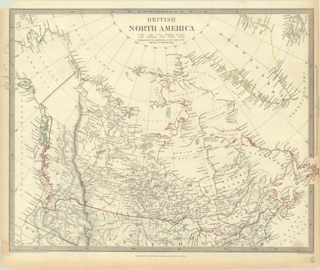
Lot 109
Subject: Canada
SDUK Society for the Diffusion of Useful Knowledge
British North America, 1834
Size: 16.3 x 12.6 inches (41.4 x 32 cm)
Estimate: $70 - $90
NO RESERVE
Sold for: $95
Closed on 6/17/2026
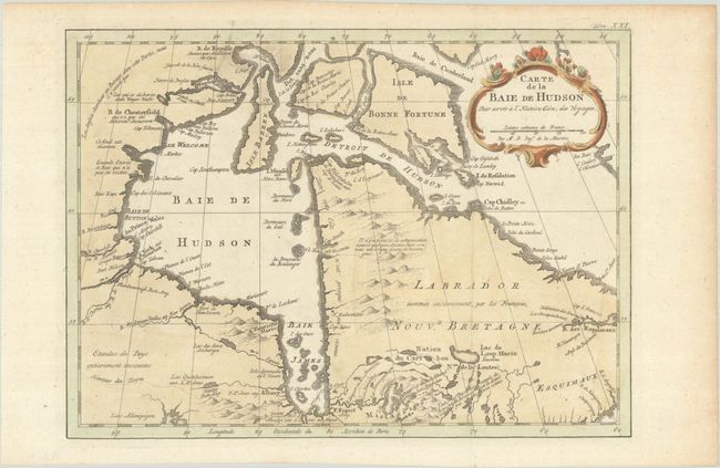
Lot 110
Subject: Eastern Canada
Bellin, Jacques Nicolas
Carte de la Baie de Hudson pour Servir a l'Histoire Gen. des Voyages, 1777
Size: 11.9 x 8.6 inches (30.2 x 21.8 cm)
Estimate: $110 - $140
Sold for: $55
Closed on 6/17/2026
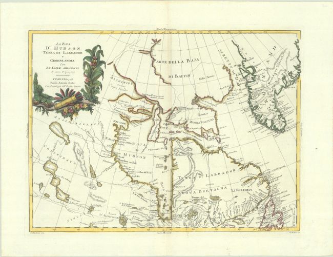
Lot 111
Subject: Eastern Canada & Greenland
Zatta, Antonio
La Baja d'Hudson Terra di Labrador e Groenlandia con le Isole Adiacenti di Nuova Projezione, 1778
Size: 16.1 x 11.8 inches (40.9 x 30 cm)
Estimate: $150 - $180
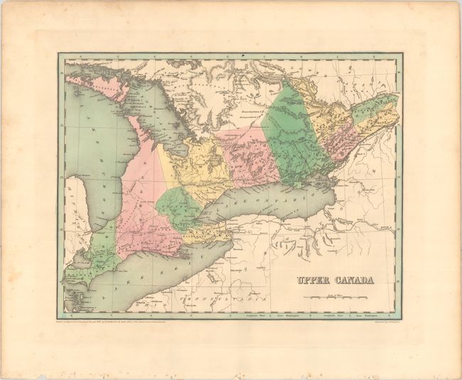
Lot 112
Subject: Eastern Canada
Bradford, Thomas Gamaliel
[Lot of 2] Upper Canada [and] Lower Canada and New Brunswick, 1838
Size: 14.4 x 11.2 inches (36.6 x 28.4 cm)
Estimate: $120 - $150
NO RESERVE
Sold for: $50
Closed on 6/17/2026
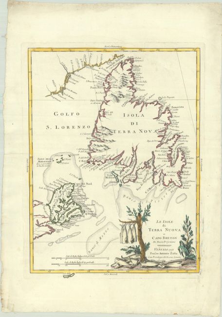
Lot 113
Subject: Newfoundland & Cape Breton Island, Canada
Zatta, Antonio
Le Isole di Terra Nuova e Capo Breton di Nuova Projezione, 1778
Size: 12.5 x 16.9 inches (31.8 x 42.9 cm)
Estimate: $300 - $375
Sold for: $220
Closed on 6/17/2026
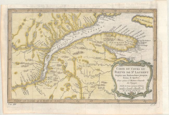
Lot 114
Subject: St. Lawrence River, Canada
Bellin, Jacques Nicolas
[Lot of 2] Carte du Cours du Fleuve de St. Laurent Depuis son Embouchure Jusqu'au Dessus de Quebec... [and] Suite du Cours du Fleuve de St. Laurent Depuis Quebec Jusqu'au Lac Ontario..., 1757
Size: 12 x 7.6 inches (30.5 x 19.3 cm)
Estimate: $190 - $220
Sold for: $140
Closed on 6/17/2026
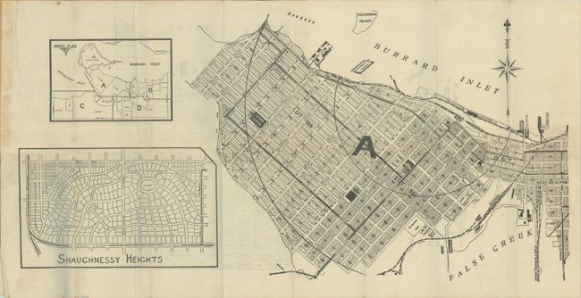
Lot 115
Subject: Vancouver, Canada
[4 Maps] T. Mathews' Vest Pocket Map of Vancouver, 1909
Size: 20.6 x 10.5 inches (52.3 x 26.7 cm)
Estimate: $550 - $700
Early Real Estate Plan of Vancouver
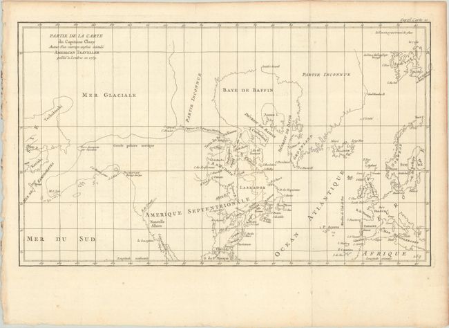
Lot 116
Subject: Colonial United States & Canada, Arctic
Robert de Vaugondy, Didier
Partie de la Carte du Capitaine Cluny Auteur d'un Ouvrage Anglois Intitule American Traveller, 1773
Size: 19.7 x 11.6 inches (50 x 29.5 cm)
Estimate: $95 - $120
Sold for: $70
Closed on 6/17/2026
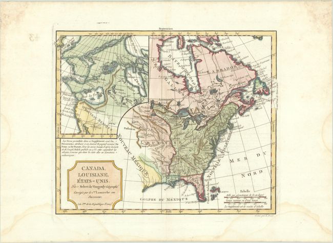
Lot 117
Subject: United States & Canada
Robert de Vaugondy/Delamarche
Canada, Louisiane, Etats-Unis, 1794
Size: 11.6 x 9.5 inches (29.5 x 24.1 cm)
Estimate: $220 - $250
Sold for: $160
Closed on 6/17/2026
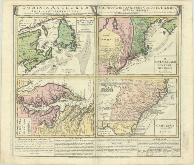
Lot 118
Subject: Colonial Eastern United States & Canada
Homann Heirs
Dominia Anglorum in America Septentrionali... / Die Gros-Britannische Colonie-Laender, in Nord-America..., 1740
Size: 21.9 x 19.8 inches (55.6 x 50.3 cm)
Estimate: $475 - $600
Sold for: $350
Closed on 6/17/2026
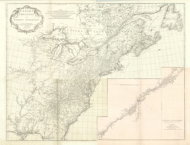
Lot 119
Subject: Colonial Eastern United States & Canada
Anville, Jean Baptiste Bourguignon d'
[On 4 Sheets] Canada Louisiane et Terres Angloises, 1755
Size: 21.9 x 18.8 inches (55.6 x 47.8 cm)
Estimate: $1,200 - $1,500
D'Anville's Spectacular Map of Eastern Seaboard
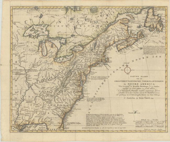
Lot 120
Subject: Colonial Eastern United States & Canada
Tirion, Isaac
Nieuwe Kaart van de Grootbrittannische Volkplantingen in Noord America waar in Tevens de Fransche Bezittingen en de Landen..., 1755
Size: 17.8 x 14.4 inches (45.2 x 36.6 cm)
Estimate: $600 - $750
Sold for: $425
Closed on 6/17/2026
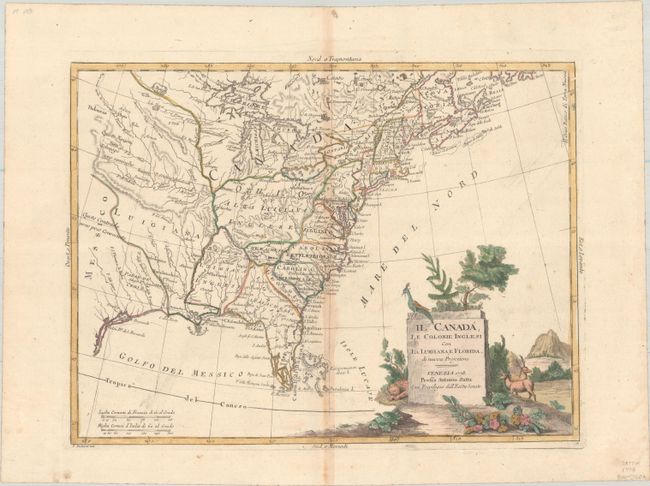
Lot 121
Subject: Colonial Eastern United States & Canada
Zatta, Antonio
Il Canada, le Colonie Inglesi con la Luigiana, e Florida di Nuova Projezione, 1778
Size: 15.9 x 11.9 inches (40.4 x 30.2 cm)
Estimate: $400 - $475
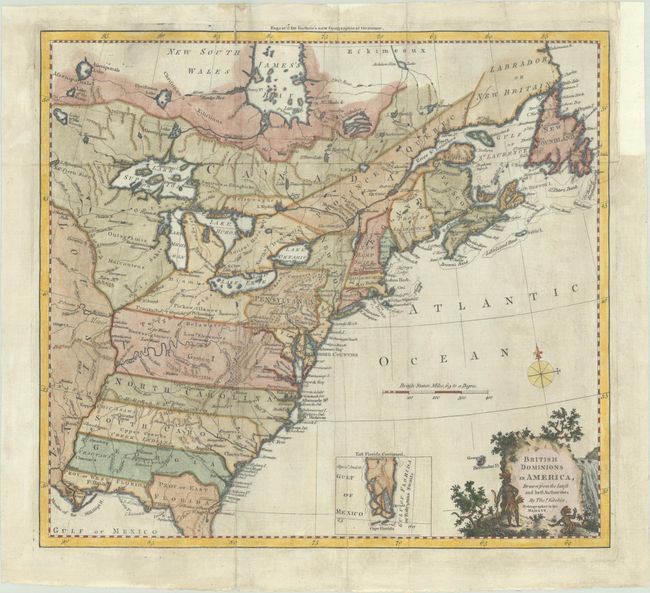
Lot 122
Subject: Colonial Eastern United States & Canada
Kitchin, Thomas
British Dominions in America, Drawn from the Latest and Best Authorities, 1780
Size: 14.9 x 13.5 inches (37.8 x 34.3 cm)
Estimate: $550 - $700
Sold for: $900
Closed on 6/17/2026
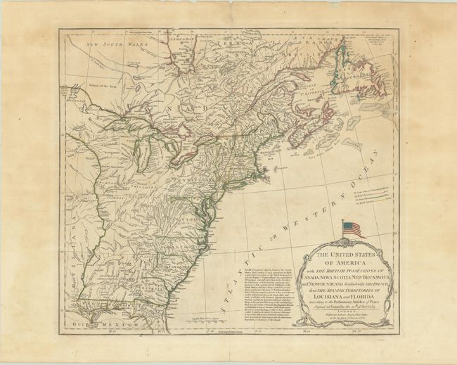
Lot 123
Subject: Eastern United States & Canada
Sayer, Robert
The United States of America with the British Possessions of Canada, Nova Scotia, New Brunswick and Newfoundland Divided with the French, Also the Spanish Territories of Louisiana and Florida..., 1790
Size: 20.3 x 18.2 inches (51.6 x 46.2 cm)
Estimate: $1,400 - $1,700
Celebrate 250 Years of Independence - This Map Features the Original Stars and Stripes
Sold for: $1,000
Closed on 6/17/2026
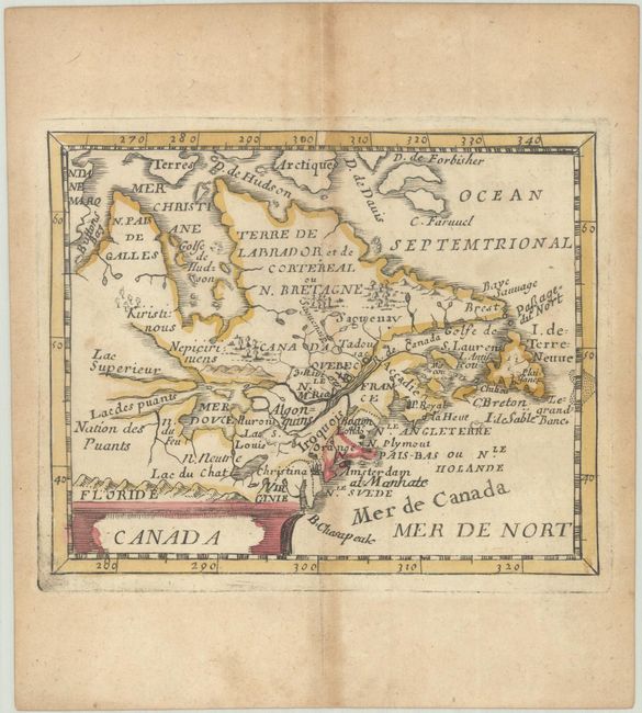
Lot 124
Subject: Colonial Northeastern United States & Canada
Duval, Pierre
Canada, 1682
Size: 4.8 x 3.9 inches (12.2 x 9.9 cm)
Estimate: $300 - $375
Sold for: $220
Closed on 6/17/2026
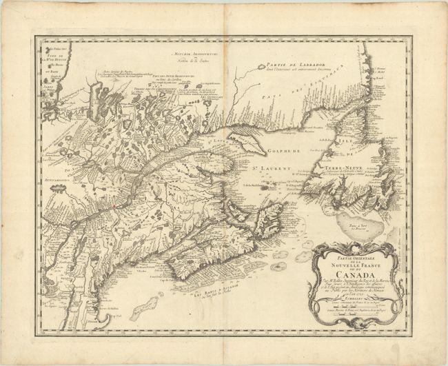
Lot 125
Subject: Colonial Northeastern United States & Canada
Bellin/Homann Heirs
Partie Orientale de la Nouvelle France ou du Canada..., 1755
Size: 21.3 x 17 inches (54.1 x 43.2 cm)
Estimate: $550 - $700
Sold for: $400
Closed on 6/17/2026
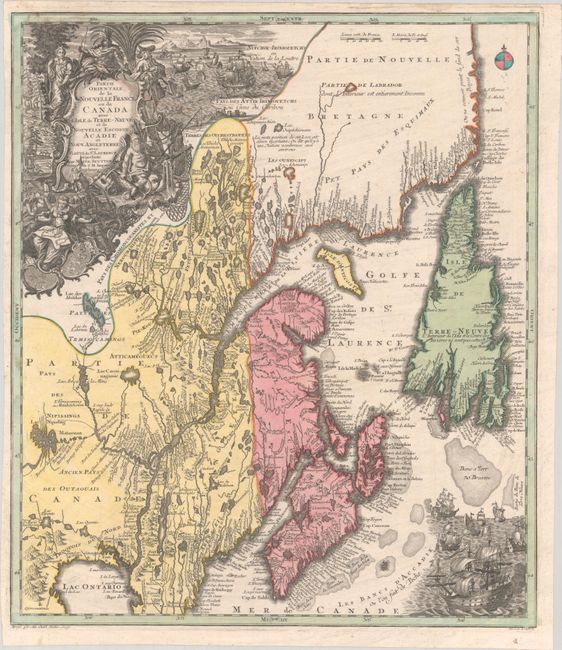
Lot 126
Subject: Colonial Northeastern United States & Canada
Seutter/Lotter
Partie Orientale de la Nouvelle France ou du Canada avec l'Isle de Terre-Neuve et de Nouvelle Escosse, Acadie et Nouv. Angleterre avec Fleuve de St. Laurence, 1756
Size: 19.4 x 22.6 inches (49.3 x 57.4 cm)
Estimate: $1,200 - $1,500
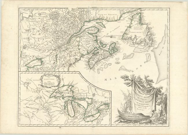
Lot 127
Subject: Colonial Northeastern United States & Canada, Great Lakes
Robert de Vaugondy, Didier
Partie de l'Amerique Septent? qui Comprend la Nouvelle France ou le Canada, 1784
Size: 23.8 x 19 inches (60.5 x 48.3 cm)
Estimate: $475 - $600
Sold for: $250
Closed on 6/17/2026
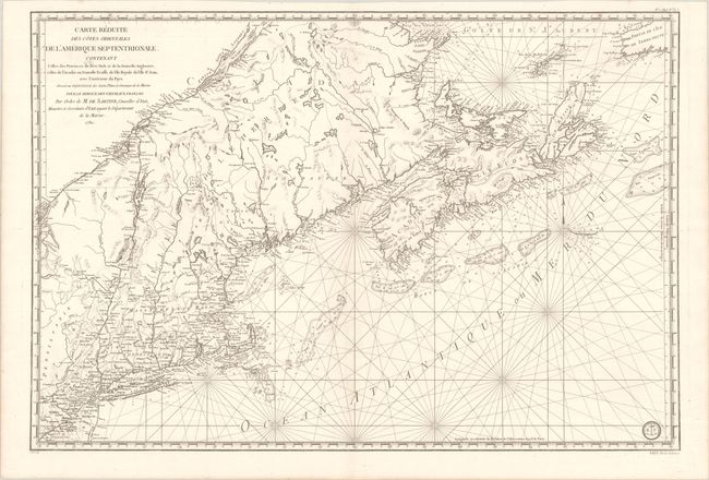
Lot 128
Subject: Colonial Northeastern United States & Canada
Sartine
Carte Reduite des Cotes Orientales de l'Amerique Septentrionale Contenant Celles des Provinces de New-York et de la Nouvelle Angleterre, Celles de l'Acadie ou Nouvelle Ecosse, de l'Ile Royale de l'Ile St. Jean..., 1780
Size: 34.3 x 23.1 inches (87.1 x 58.7 cm)
Estimate: $1,100 - $1,400
Price reduced by $125! Revolutionary War-Era Sea Chart Covering New England & Eastern Canada
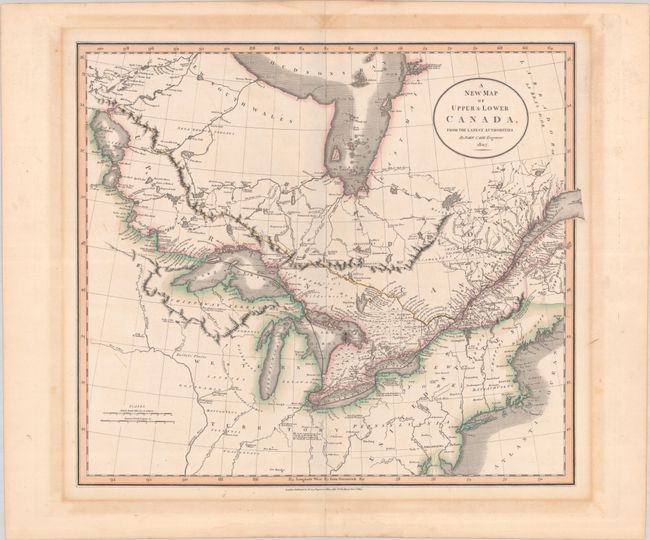
Lot 129
Subject: Northeastern United States & Canada
Cary, John
A New Map of Upper & Lower Canada, from the Latest Authorities, 1807
Size: 20.6 x 18.1 inches (52.3 x 46 cm)
Estimate: $475 - $600
Price reduced by $150!
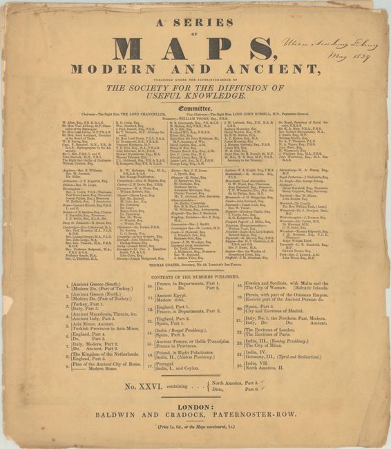
Lot 130
Subject: Northeastern United States & Canada
SDUK Society for the Diffusion of Useful Knowledge
[2 Maps] A Series of Maps, Modern and Ancient ... No. XXVI. Containing... North America, Part 3 - Ditto, Part 6, 1832
Size: 14.6 x 16.7 inches (37.1 x 42.4 cm)
Estimate: $180 - $220
Sold for: $90
Closed on 6/17/2026
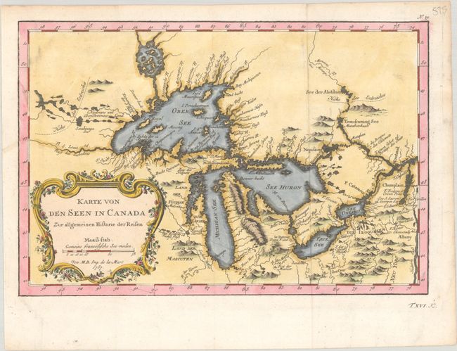
Lot 131
Subject: Colonial Great Lakes
Bellin, Jacques Nicolas
Karte von den Seen in Canada zur Allgemeinen Historie der Reisen, 1757
Size: 11.3 x 7.6 inches (28.7 x 19.3 cm)
Estimate: $400 - $475
Sold for: $325
Closed on 6/17/2026
23 lots