Subject: Eastern United States & Canada
Period: 1790 (dated)
Publication:
Color: Hand Color
Size:
20.3 x 18.2 inches
51.6 x 46.2 cm
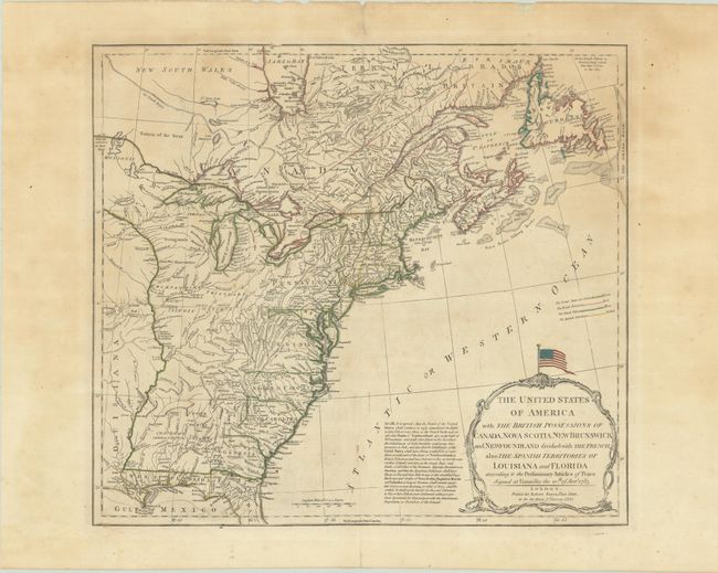
This map had a long publication history. It was prepared by Thomas Jefferys and first published in 1755, with the title North America from the French of Mr. D'Anville..., to illustrate the French and Indian War. In this state, published by Robert Sayer, it illustrates the nascent United States. New England is shown extending well into New Brunswick, and there are several changes in the shoal areas of the Gulf of Maine and the important nearby fishing banks. The map is very detailed with the locations of forts, Indian villages, tribal territory, and mines. West and East Florida are Spanish possessions. The large, decorative title cartouche is surmounted by the American flag with both 13 stars and stripes, representing the original thirteen colonies. The stars here are arranged in a 3-2-3-2-3 design or Francis Hopkinson pattern. The text of Article III of the Treaty of Paris is printed to the left of the cartouche, referring to the fishing rights of the United States.
This is the first edition of the map to include the flag atop the title cartouche. This 1790 edition is not mentioned in McCorkle, Sellers & Van Ee or Stevens & Tree.
References: Baynton-Williams #18 (Map Forum, Vol. 1); McCorkle #755.2; McGuirk (Portolan - Winter 2018) pp. 45-54; Sellers & Van Ee #752; Stevens & Tree (MCC-39) #51.
Condition: B+
Contemporary outline color on a sheet with Strasbourg Lily watermark. There is some scattered foxing, minor soiling, and light toning and dampstaining in the upper image. Minor edge tears and chips confined to the top and bottom blank margins have been archivally repaired on verso.