Showing Featured Lots(remove filter)
Showing results for:Auction 117
Catalog Archive
73 lots
Page 1 of 2
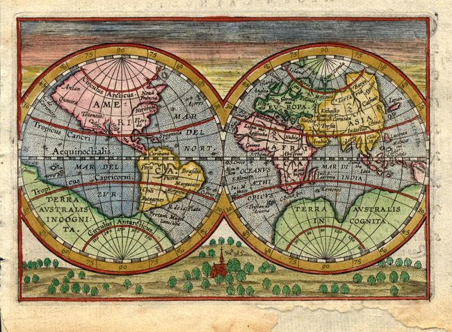
Auction 117, Lot 4
Subject: World & Continents
Ortelius/Vrients
[Lot of 5 ] [Untitled - World] [and] America [and] Asia [and] Africa [and] Europa, 1602
Size: 5 x 3.4 inches (12.7 x 8.6 cm)
Estimate: $3,000 - $3,500
Unsold
Closed on 12/6/2006
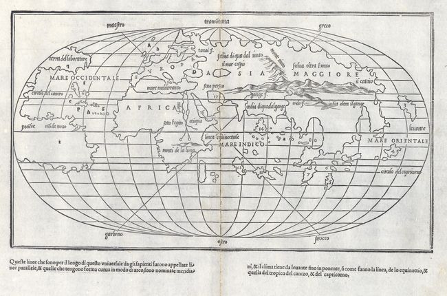
Auction 117, Lot 7
Subject: World
Bordone, Benedetto
[Untitled - World], 1528
Size: 15 x 8.5 inches (38.1 x 21.6 cm)
Estimate: $4,000 - $5,000
Sold for: $3,000
Closed on 12/6/2006
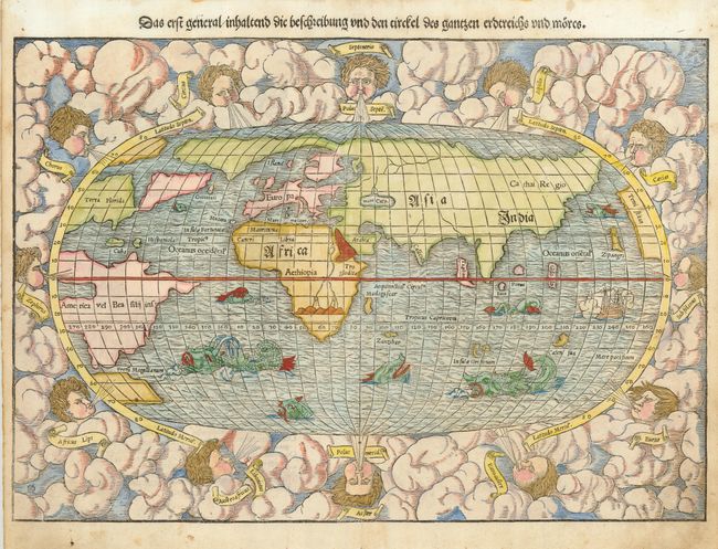
Auction 117, Lot 8
Subject: World
Munster, Sebastian
Das erst general inhaltend die beschreibung und den circkel des gantzen erdtreichs und moeres, 1550
Size: 15 x 10.4 inches (38.1 x 26.4 cm)
Estimate: $2,500 - $3,000
Sold for: $2,000
Closed on 12/6/2006
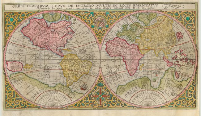
Auction 117, Lot 11
Subject: World
Plancius, Petrus
Orbis Terrarum Typus de Integro Multis in Locis Emendatus, 1620
Size: 20.3 x 11.3 inches (51.6 x 28.7 cm)
Estimate: $2,000 - $2,500
Sold for: $1,700
Closed on 12/6/2006

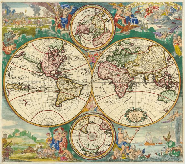
Auction 117, Lot 12
Subject: World
Kaerius/Jansson
Nova Totius Terrarum Orbis Geographica ac Hydrographica Tabula, 1630
Size: 21 x 15.7 inches (53.3 x 39.9 cm)
Estimate: $9,000 - $12,000
Unsold
Closed on 12/6/2006
Auction 117, Lot 22
Subject: World
Wit, Frederick de
Nova Totius Terrarum Orbis Tabula, 1745
Size: 22.5 x 19.8 inches (57.2 x 50.3 cm)
Estimate: $6,000 - $7,000
Unsold
Closed on 12/6/2006
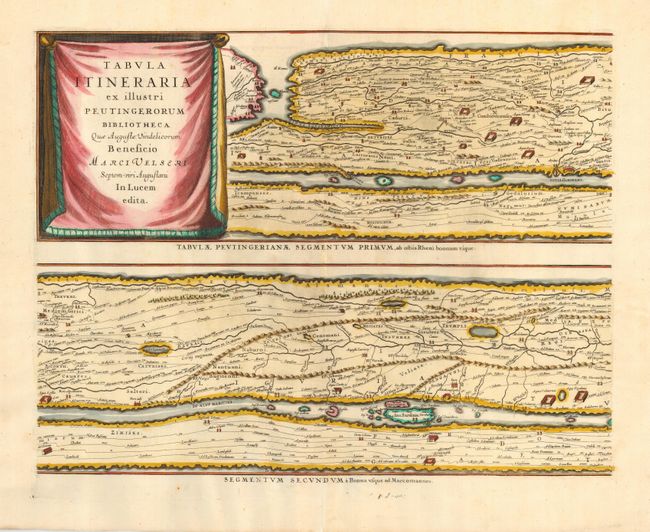
Auction 117, Lot 28
Subject: Ancient World
Jansson, Jan
Tabula Itineraria ex Illustri Peutingerorum Bibliotheca…, 1662
Size: 20 x 15.5 inches (50.8 x 39.4 cm)
Estimate: $2,400 - $3,000
Sold for: $1,800
Closed on 12/6/2006
Auction 117, Lot 31
Subject: Polar
Coronelli, Vincenzo Maria
[Lot of 2 - Untitled Globe Gores - North and South Pole], 1695
Size: 14.5 x 14.5 inches (36.8 x 36.8 cm)
Estimate: $1,000 - $1,400
Sold for: $1,000
Closed on 12/6/2006
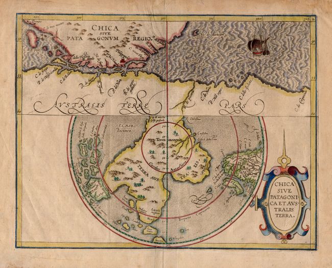
Auction 117, Lot 32
Subject: Antarctica
Wytfliet, Cornelis
Chica sive Patagonica et Australis Terra, 1598
Size: 11.5 x 9 inches (29.2 x 22.9 cm)
Estimate: $1,300 - $1,500
Sold for: $1,200
Closed on 12/6/2006
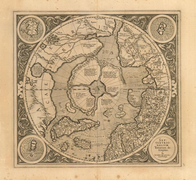
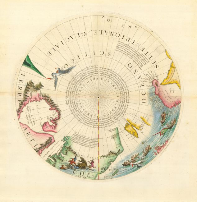
Auction 117, Lot 36
Subject: North Pole
Mercator, Gerard
Septentrionalium Terrarum descriptio, 1613
Size: 15.5 x 14.5 inches (39.4 x 36.8 cm)
Estimate: $1,800 - $2,500
Sold for: $1,800
Closed on 12/6/2006
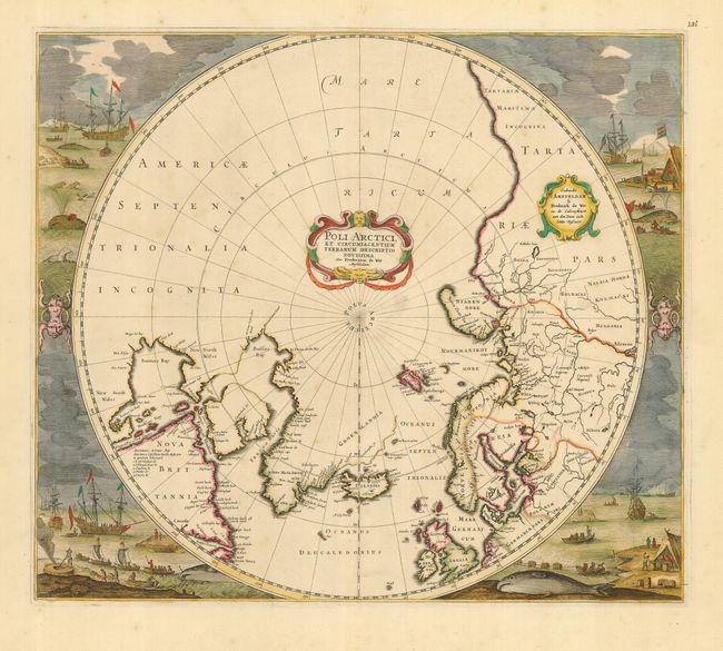
Auction 117, Lot 38
Subject: North Pole
Hondius/deWit
Poli Arctici, et Circumiacentium Terrarum Descriptio Novissima, 1676
Size: 19.4 x 17 inches (49.3 x 43.2 cm)
Estimate: $1,000 - $1,400
Sold for: $1,500
Closed on 12/6/2006
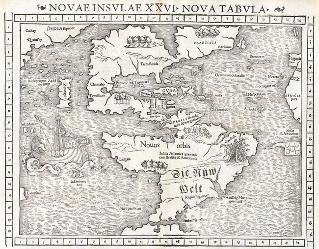
Auction 117, Lot 64
Subject: Western Hemisphere
Munster, Sebastian
Novae Insulae XXVI Nova Tabula, 1552
Size: 13.5 x 10 inches (34.3 x 25.4 cm)
Estimate: $5,000 - $6,000
Sold for: $6,500
Closed on 12/6/2006
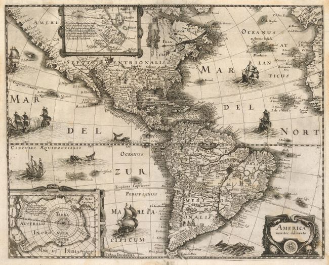
Auction 117, Lot 66
Subject: Western Hemisphere
Merian, Matthaus
America noviter delineata, 1631
Size: 17.4 x 13.7 inches (44.2 x 34.8 cm)
Estimate: $2,300 - $2,500
Sold for: $1,600
Closed on 12/6/2006
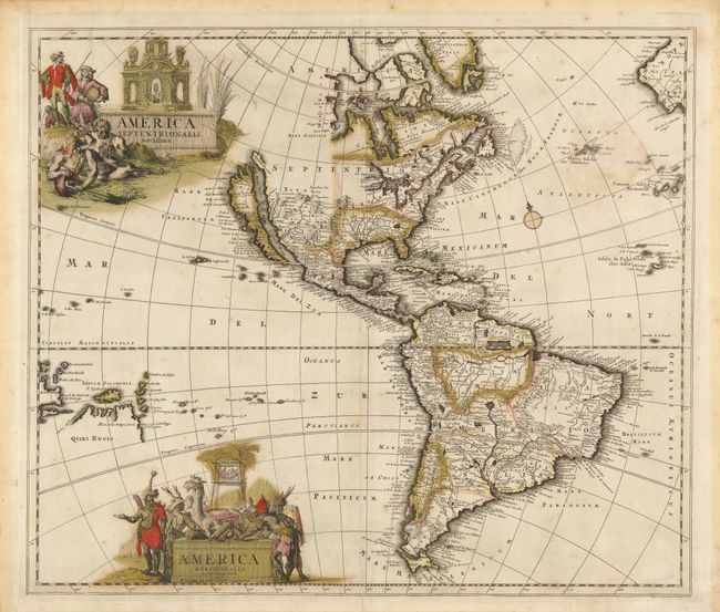
Auction 117, Lot 67
Subject: Western Hemisphere
Schenk, Pieter
Amferica Septentrionalis Novissima / America Meridionalis Accuratissima, 1695
Size: 22.4 x 19 inches (56.9 x 48.3 cm)
Estimate: $1,400 - $1,800
Sold for: $800
Closed on 12/6/2006
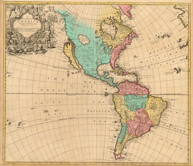
Auction 117, Lot 69
Subject: Western Hemisphere
Senex, John
A New Map of America from the latest Observations, 1719
Size: 22 x 19 inches (55.9 x 48.3 cm)
Estimate: $2,200 - $2,500
Sold for: $1,200
Closed on 12/6/2006
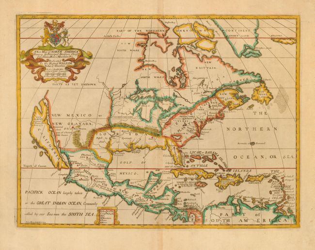
Auction 117, Lot 80
Subject: North America
Wells, Edward
A New Map of North America Shewing its Principal Divisions, Chief Cities, Townes, Rivers, Mountains, &c., 1700
Size: 19.3 x 14.5 inches (49 x 36.8 cm)
Estimate: $2,000 - $2,400
Unsold
Closed on 12/6/2006
Auction 117, Lot 87
Subject: North America
Probst, Johann Michael
Nova Mappa Geographica Americae Septentrionalis in suas praecipuas Partes divisa, 1782
Size: 19 x 19.5 inches (48.3 x 49.5 cm)
Estimate: $2,500 - $3,250
Sold for: $1,500
Closed on 12/6/2006
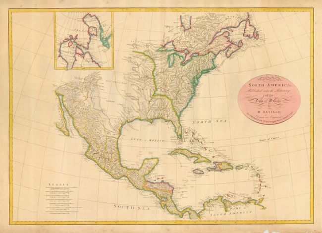
Auction 117, Lot 88
Subject: North America
Harrison, John
A Map of North America; Published under the Patronage of the Duke of Orleans by D'Anville, 1791
Size: 28 x 19.7 inches (71.1 x 50 cm)
Estimate: $1,200 - $1,500
Unsold
Closed on 12/6/2006
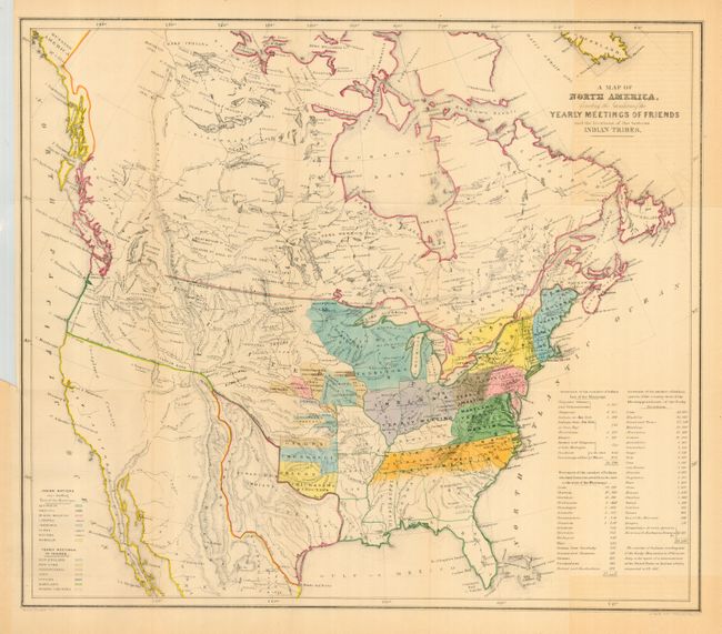
Auction 117, Lot 90
Subject: North America
A Map of North America Denoting the Boundaries of the Yearly Meetings of Friends and the Locations of the Various Indian Tribes, 1844
Size: 21 x 18 inches (53.3 x 45.7 cm)
Estimate: $300 - $500
Sold for: $650
Closed on 12/6/2006
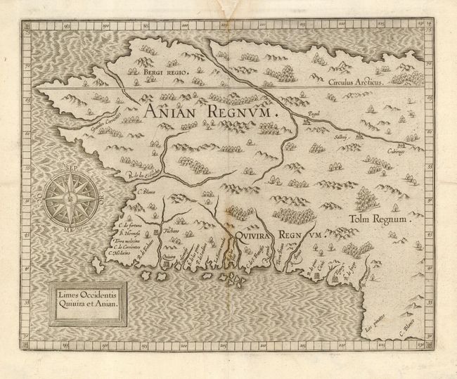
Auction 117, Lot 94
Subject: Western Canada & Alaska
Wytfliet, Cornelis
Limes Occidentis Quivira et Anian, 1607
Size: 11.5 x 9.2 inches (29.2 x 23.4 cm)
Estimate: $1,900 - $2,100
Unsold
Closed on 12/6/2006
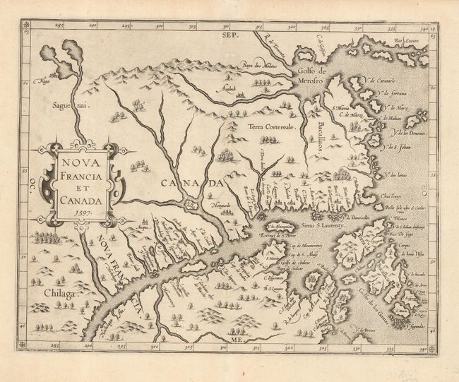
Auction 117, Lot 96
Subject: Canada
Wytfliet, Cornelis
Nova Francia et Canada, 1597
Size: 11.5 x 9 inches (29.2 x 22.9 cm)
Estimate: $1,400 - $2,000
Sold for: $2,000
Closed on 12/6/2006
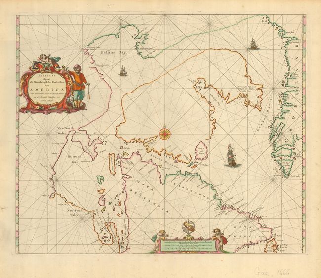
Auction 117, Lot 98
Subject: Canada and Greenland
Goos, Pieter
Paskaert Zijnde de Noordelijckste Zeekusten van America Van Groenland door de Straet Davis en de Straet Hudson tot Terra Neuf, 1666
Size: 21.2 x 17.4 inches (53.8 x 44.2 cm)
Estimate: $1,100 - $1,800
Sold for: $850
Closed on 12/6/2006
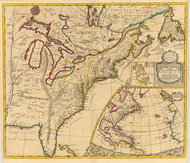
Auction 117, Lot 114
Subject: Colonial United States and Canada
Morden/Senex
A New Map of the English Empire in America viz Virginia, Maryland, Carolina, New York, New Iarsey, New England…, 1719
Size: 23.3 x 19.8 inches (59.2 x 50.3 cm)
Estimate: $2,000 - $2,500
Sold for: $2,500
Closed on 12/6/2006

Auction 117, Lot 115
Subject: Colonial North America and Caribbean
Seutter, Matthias
Accurata delineatio celeberrimae Regionis Ludovicianae vel Gallice Louisiane ol Canadae et Floridae adpellatione in Septemtrionali America descripta quae hodie nomine fluminis Mississippi vel St. Louis…, 1740
Size: 22 x 19 inches (55.9 x 48.3 cm)
Estimate: $2,500 - $3,000
Sold for: $2,400
Closed on 12/6/2006
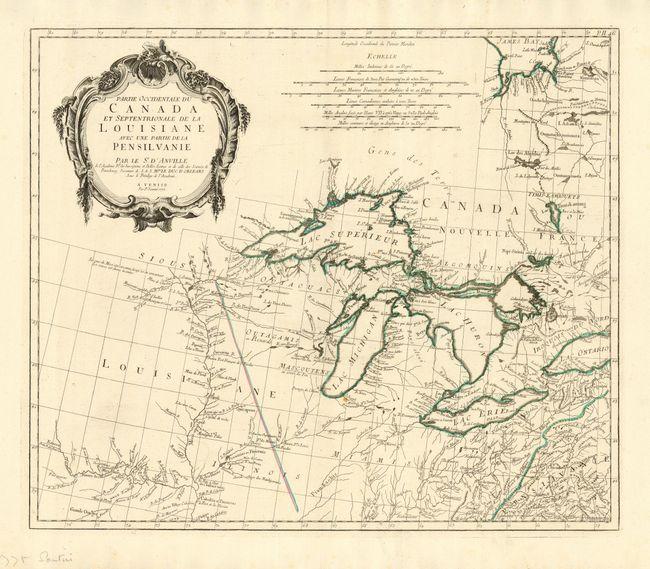
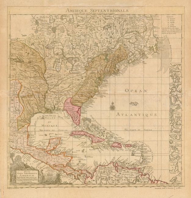
Auction 117, Lot 126
Subject: Colonial Great Lakes
D'Anville/Santini
Partie Occidentale du Canada et Septentrionale de la Louisiane avec une partie de la Pensilvanie, 1775
Size: 22.3 x 18.9 inches (56.6 x 48 cm)
Estimate: $1,100 - $1,300
Sold for: $750
Closed on 12/6/2006
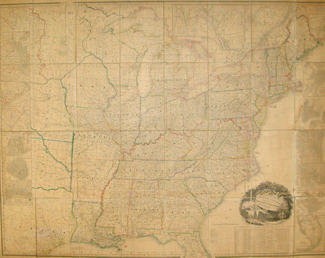
Auction 117, Lot 138
Subject: United States
Tanner, Henry Schenck
A Map of the United States Including Every County Enumerated in the Last Census & Since Formed with Population, of the several States, Railroads Canals &c., 1845
Size: 61 x 46 inches (154.9 x 116.8 cm)
Estimate: $14,000 - $18,000
Unsold
Closed on 12/6/2006
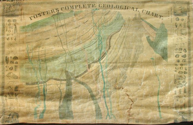
Auction 117, Lot 141
Subject: United States
Foster, J.T.
Foster's Complete Geological Chart. Exhibiting in their Successive Order of Deposition, the Various Rocks, Which Form the Crust of our Globe, Arranged According to the Best Authorities in Europe & America, 1849
Size: 67.5 x 47.5 inches (171.5 x 120.7 cm)
Estimate: $300 - $500
Sold for: $210
Closed on 12/6/2006
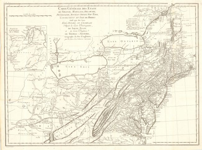
Auction 117, Lot 148
Subject: Eastern United States
Crevecoeur, Michel Guillaume De
Carte Generale des Etats de Virginie, Maryland, Delaware, Pensilvanie, Nouveau-Jersey, New-York, Connecticut et Isle de Rhodes Ainsi que des Lacs Erie, Ontario, et Champlain…, 1787
Size: 25.6 x 18.8 inches (65 x 47.8 cm)
Estimate: $1,500 - $1,800
Unsold
Closed on 12/6/2006
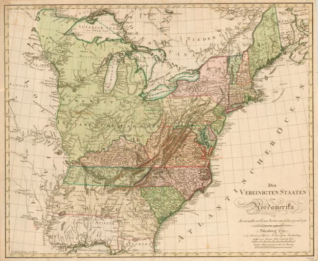
Auction 117, Lot 149
Subject: Eastern United States
Schneider and Weigel
Die Vereinigten Staaten von Nordamerika…, 1799
Size: 25.5 x 21 inches (64.8 x 53.3 cm)
Estimate: $3,000 - $3,250
Sold for: $2,400
Closed on 12/6/2006

Auction 117, Lot 152
Subject: Eastern United States
Norie, John William
Chart of North America from Boston to the Strait of Florida and Havana, 1896
Size: 105.5 x 33.75 inches (268 x 85.7 cm)
Estimate: $1,200 - $2,500
Sold for: $1,800
Closed on 12/6/2006
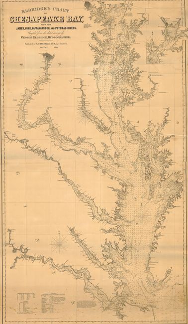
Auction 117, Lot 160
Subject: United States - Mid-Atlantic
Eldridge, George
Eldridge's Chart of Chesapeake Bay with the James, York, Rappahannock and Potomac Rivers, 1898
Size: 32.5 x 56.5 inches (82.6 x 143.5 cm)
Estimate: $1,500 - $2,000
Sold for: $950
Closed on 12/6/2006
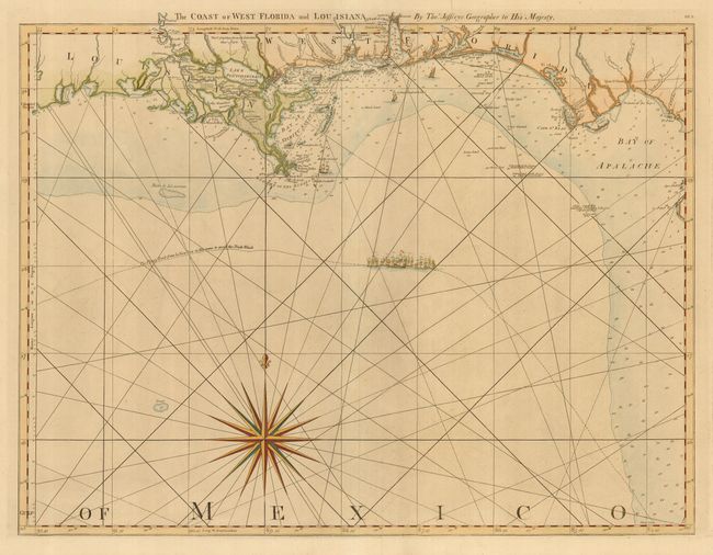
Auction 117, Lot 165
Subject: Colonial Southern United States
Jefferys, Thomas
The Coast of West Florida and Louisiana, 1775
Size: 24.5 x 18.8 inches (62.2 x 47.8 cm)
Estimate: $1,600 - $1,800
Sold for: $1,700
Closed on 12/6/2006
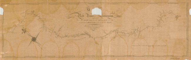
Auction 117, Lot 170
Subject: Southern United States
King, Nicholas
Map of the Red River in Louisiana from the Spanish Camp Where the Exploring Party of the U.S. was met by the Spanish Troops to where it enters the Mississippi, 1806
Size: 27.8 x 8.1 inches (70.6 x 20.6 cm)
Estimate: $15,000 - $25,000
Sold for: $31,000
Closed on 12/6/2006
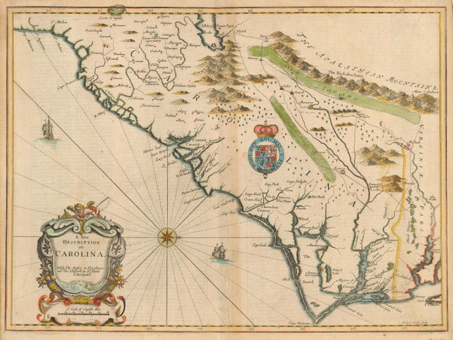
Auction 117, Lot 174
Subject: Colonial Southeast United States
Speed/Lamb
A New Description of Carolina, 1676
Size: 20 x 14.6 inches (50.8 x 37.1 cm)
Estimate: $3,500 - $5,000
Sold for: $2,500
Closed on 12/6/2006
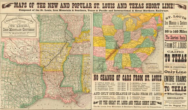
Auction 117, Lot 190
Subject: United States - Texas and Midwest
Railroad Companies, (Various)
Maps of the New and Popular St. Louis and Texas Short Line! Composed of the St. Louis, Iron Mountain & Southern, Texas & Pacific and International & Great Northern Railways, 1878
Size: 31 x 18 inches (78.7 x 45.7 cm)
Estimate: $500 - $700
Sold for: $600
Closed on 12/6/2006
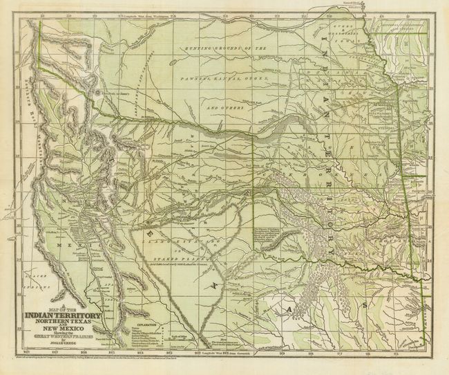
Auction 117, Lot 204
Subject: South-Central United States, Indian Territory
Gregg, Josiah
A Map of the Indian Territory Northern Texas and New Mexico Showing the Great Western Prairies, 1844
Size: 14.9 x 12.3 inches (37.8 x 31.2 cm)
Estimate: $500 - $700
Sold for: $1,000
Closed on 12/6/2006
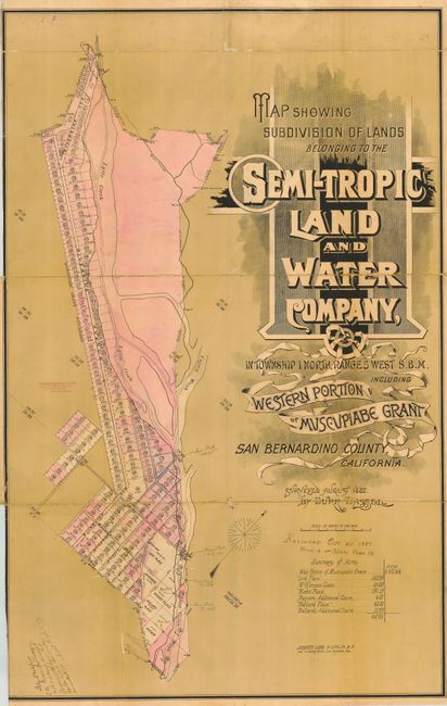
Auction 117, Lot 228
Subject: California - Rialto
[Lot of 2] Map Showing Subdivision of Lands Belonging to the Semi-Tropic Land and Water Company [together with] Map of the Town of Rialto, 1887
Size: See Description
Estimate: $350 - $500
Sold for: $400
Closed on 12/6/2006
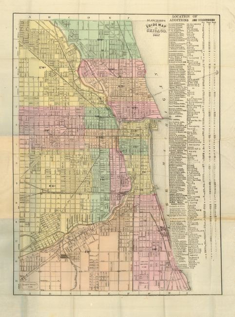
Auction 117, Lot 254
Subject: Illinois, Chicago
Blanchard & Cram
Blanchard's Guide Map of Chicago, 1867
Size: 13 x 18.3 inches (33 x 46.5 cm)
Estimate: $800 - $1,200
Sold for: $400
Closed on 12/6/2006
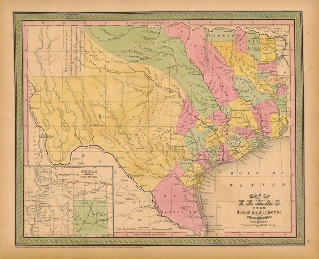
Auction 117, Lot 326
Subject: Texas
Thomas, Cowperthwait & Co.
Map of Texas from the most recent authorities, 1850
Size: 15 x 12 inches (38.1 x 30.5 cm)
Estimate: $800 - $1,200
Sold for: $750
Closed on 12/6/2006
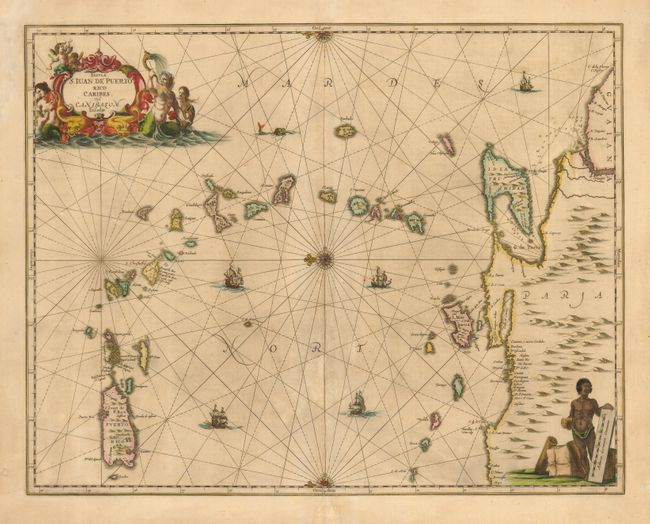
Auction 117, Lot 377
Subject: Lesser Antilles
Jansson, Jan
Insula S. Iuan de Puerto Rico Caribes vel Canibasum Insulae, 1658
Size: 20 x 16 inches (50.8 x 40.6 cm)
Estimate: $1,000 - $1,200
Sold for: $550
Closed on 12/6/2006
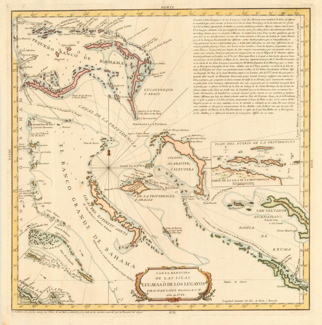
Auction 117, Lot 389
Subject: Bahamas
Lopez, Juan (don)
Carta Reducida de las Islas Lucayas, o de los Lucayos Por D. Juan Lopez, 1782
Size: 15.5 x 15.5 inches (39.4 x 39.4 cm)
Estimate: $1,200 - $1,400
Sold for: $1,300
Closed on 12/6/2006
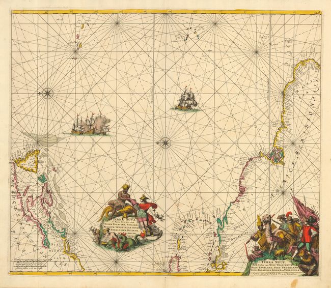
Auction 117, Lot 417
Subject: Atlantic Ocean
Wit, Frederick de
Terra Nova, ac Maris Tractus circa Novam Franciam, Angliam, Belgium, Venezuelam Novam Andalusiam Guinam et Brasiliam - Terra Neuf, en de Custen van Nieu Vranckryck, Nieu Engeland, Nieu Nederland, Nieu Andalusia, Guiana en Venezuela, 1680
Size: 22.2 x 19 inches (56.4 x 48.3 cm)
Estimate: $1,900 - $2,200
Sold for: $1,500
Closed on 12/6/2006
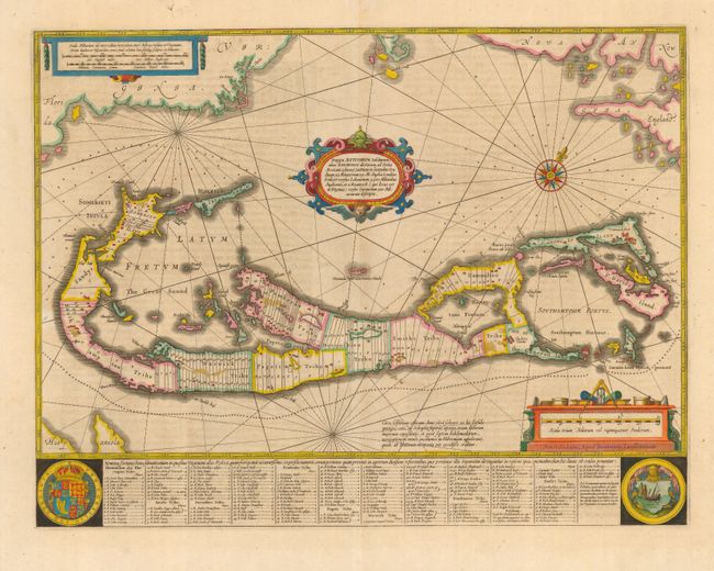
Auction 117, Lot 418
Subject: Bermuda
Hondius/Jansson
Mappa Aestivarum Insularum, alias Barmudas Dictarum…, 1647
Size: 20 x 15.4 inches (50.8 x 39.1 cm)
Estimate: $2,200 - $2,750
Sold for: $2,000
Closed on 12/6/2006
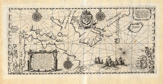
Auction 117, Lot 422
Subject: North Atlantic - Canada, Greenland and Iceland
Bry, Theodore de
Tabula Nautica, qua repraesentantur orae maritimae meatus, ac freta, noviter a H Hudsono Anglo ad Caurum supra Novam Franciam indagata Anno 1612, 1613
Size: 12.8 x 5.8 inches (32.5 x 14.7 cm)
Estimate: $2,000 - $3,000
Sold for: $2,000
Closed on 12/6/2006
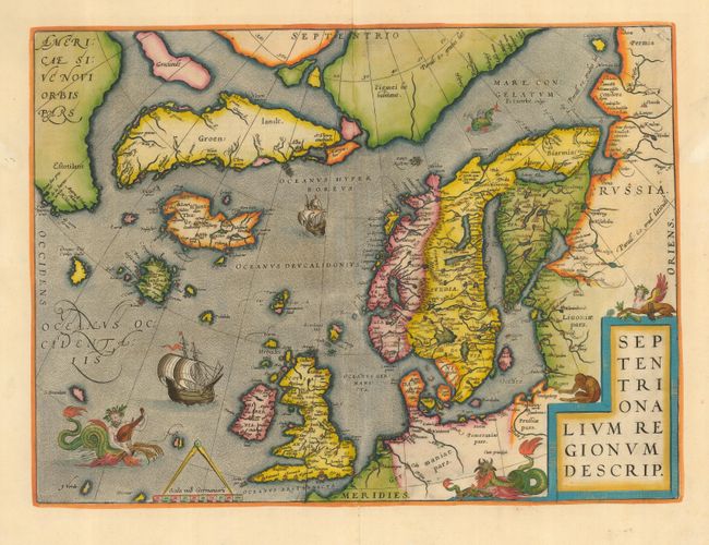
Auction 117, Lot 429
Subject: Arctic and Scandinavia
Ortelius, Abraham
Septentrionalium Regionum Descrip., 1570
Size: 19.5 x 14.1 inches (49.5 x 35.8 cm)
Estimate: $2,300 - $3,000
Sold for: $2,300
Closed on 12/6/2006
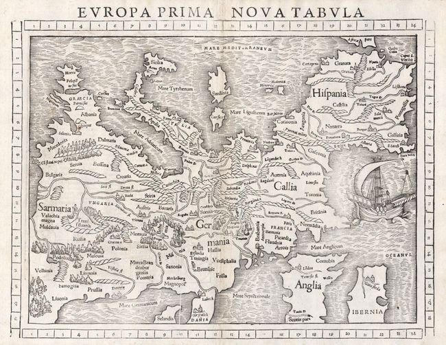
Auction 117, Lot 432
Subject: Europe
Munster, Sebastian
Europa Prima Nova Tabula, 1552
Size: 13.3 x 10 inches (33.8 x 25.4 cm)
Estimate: $900 - $1,100
Sold for: $1,400
Closed on 12/6/2006
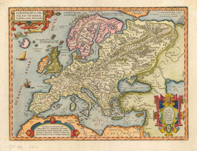
Auction 117, Lot 433
Subject: Europe
Ortelius, Abraham
Europam, sive Celticam Veterem, 1595
Size: 18.8 x 14 inches (47.8 x 35.6 cm)
Estimate: $1,400 - $1,800
Sold for: $1,300
Closed on 12/6/2006
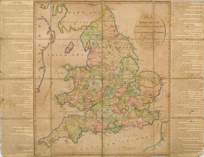
Auction 117, Lot 452
Subject: England & Wales - Geographic Game
Wallis, John
Wallis's Tour through England and Wales, A New Geographical Pastime, 1794
Size: 17.8 x 19.8 inches (45.2 x 50.3 cm)
Estimate: $750 - $1,200
Unsold
Closed on 12/6/2006
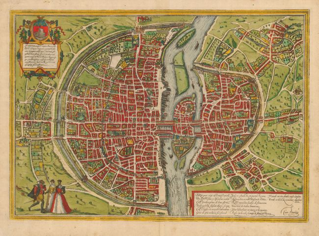
Auction 117, Lot 541
Subject: France, Paris
Braun & Hogenberg
Lutetia vulgari Nomine Paris, Urbs Galliae Maxima, Sequana Navigabili Flumine Irrigatur…, 1572
Size: 19 x 13.5 inches (48.3 x 34.3 cm)
Estimate: $1,600 - $2,000
Sold for: $1,400
Closed on 12/6/2006
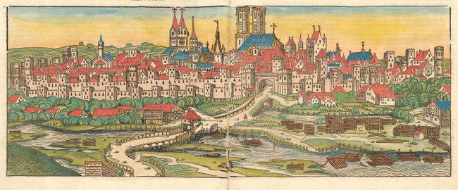
Auction 117, Lot 554
Subject: Germany, Munich
Schedel, Hartmann
CCXXVI - Monacum [Munich], 1493
Size: 21 x 8 inches (53.3 x 20.3 cm)
Estimate: $1,000 - $1,200
Sold for: $850
Closed on 12/6/2006
73 lots
Page 1 of 2