Catalog Archive
Auction 117, Lot 170

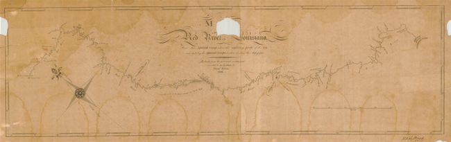
"Map of the Red River in Louisiana from the Spanish Camp Where the Exploring Party of the U.S. was met by the Spanish Troops to where it enters the Mississippi", King, Nicholas

Subject: Southern United States

Period: 1806 (dated)

Publication: An Account of the Red River, in Louisiana…

Color: Black & White

Size:
27.8 x 8.1 inches
70.6 x 20.6 cm
Download High Resolution Image
(or just click on image to launch the Zoom viewer)

The title continues "Reduced from the protracted courses and corrected to the Latitude by Nichs. King. 1806. Engrav'd by F. Shallus, Philada." This is the genuinely rare map of the exploration of the Red River by Thomas Freeman, surveyor, and Dr. Peter Custis, naturalist, through parts of Arkansas, Louisiana, Texas, and Oklahoma. They were accompanied in the spring of 1806 by a military escort under the command of Capt. Richard Sparks. At the same time that Pike was exploring westward into the Louisiana Territory, Freeman and Custis traveled along the Red River to a site in present-day Texas in the vicinity of the old Caddo villages where they were stopped by a force of Spanish cavalry protecting the Spanish claims to an ill-defined boundary of the Louisiana Purchase. After a brief skirmish, Freeman and Custis withdrew. Because of the political sensitivity surrounding the encounter with the Spanish, Eberstadt and Howes note that the report of their exploration was kept secret, with only a few copies printed. This would account for it being one of the rarest items described by Wagner-Camp, with no copies at auction since a sale in 1967 for $3,500.

The map was drawn by King, a friend of Jefferson, and War Department cartographer who compiled significant maps for Lewis & Clark's use during their journey and who later compiled maps of their findings. The LOC notes this is his final map.

This example has the additional cachet of being signed by "Wash. Hood," a Topographical Engineer who explored and mapped the west before dying prematurely at age 32. The map shows evidence of intensive use. It is water-stained, browned, and torn with some loss in the title and in one border. It is possible that this map accompanied Hood on his journeys west.

We find no references for the map itself, only to the report, and no indication in Howes, Eberstadt, Wagner-Camp or Streeter (Texas) that the map actually accompanied the report. The copy in the Library of Congress is also imperfect, but in better condition than this example. Click here to see the example in the LOC.

References: Wagner & Camp 6b; Streeter (Texas) 1040.

Condition: D

The map has significant wear. Missing a 1" panel in title with loss. Also a small section of margin missing at left and right with small loss of neatline at left side. One fold line has a split, and a tear at right enters map 1" with evidence of old tape repair on verso. Toned and stained.

Estimate: $15,000 - $25,000

Sold for: $31,000

Closed on 12/6/2006

Archived