Subject: United States - Texas and Midwest
Period: 1878 (circa)
Publication:
Color: Printed Color
Size:
31 x 18 inches
78.7 x 45.7 cm
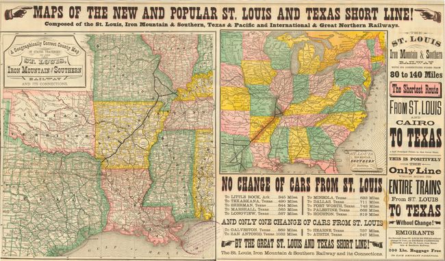
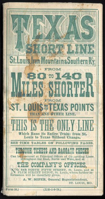
Folding pocket railroad timetable that promises "80 to 140 Miles Shorter from St. Louis to Texas Points than any other line." Great ephemera advertising piece with two maps on one side and marketing text on the other. The maps are: A Geographically Correct County Map of States Traversed by the St. Louis, Iron Mountain & Southern Railway and its Connections (16.2 x 15.2"); and Map of the St. Louis Iron Mountain and Southern Railway, and Connections (10 x 11.8"), shows the U.S. as far west as central Texas to include Austin and San Antonio. Extremely decorative with wonderful exhortations such as, Emigrants Go through from ST. LOUIS TO TEXAS without change of Cars, on EXPRESS PASSENGER TRAINS, over the St. Louis, Iron Mountain & Southern Railway. 200 Lbs. Baggage Free to each emigrant passenger. The map was stamped in the blank area by Henry H. Hannan, Land and Emigration Agent from Swan Creek, Ohio.
On the verso are a couple more of the land agent's stamps as well as wonderful advertising for the railroad line. There is an invitation to emigrants from the Governor of Texas, R.B. Hubbard, extolling the numerous virtues of his state and noting the Moral Advancement as well as Homestead Exemptions available. A great document of Texas and the rush for westward emigration during the 19th century.
References:
Condition: B
Very nice example of this folding map with a stain in a primarily blank area of the sheet and a couple of the typical fold separations at intersections.