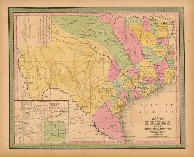
Subject: Texas
Period: 1850 (dated)
Publication: Mitchell's New Universal Atlas
Color: Hand Color
Size:
15 x 12 inches
38.1 x 30.5 cm
An early, excellent map of the state that was first issued in 1846 by Mitchell. This edition shows all of Texas with the panhandle in an inset "Texas North of the Red River" at lower left. Great details of existing counties, towns, villages, with the mountains indicated via hachure. The comment in the panhandle claims that the area "as far as North Canadian Fork was explored by Le Grand in 1833, [and] it is naturally fertile, well wooded, and with a fair proportion of water" is from Arrowsmith's 1841 map. The counties are current to about 1847. San Patricio occupies the south tip while Milam and Robertson are long counties that begin at the Nacogdoches - San Antonio road and arc to the northwest all the way to the Red River. Locates Fort Alamo, mines, and the Presidios of Rio Grande, del Norte el de las Yuntas, del Paso del Norte and others. Also delineate many early roads.
Thomas, Cowperthwaite & Co. purchased rights to Mitchell's atlas. Mitchell had made very few changes to this plate since 1846, accounting for the county layout we see here and suggesting this is from the rare first Thomas, Cowperthwait edition. Surrounded by decorative border in characteristic green hand coloring.
References:
Condition: B
Full margins and original color. A little uneven toning in the Gulf and toned more at outside of margins.