Subject: North Atlantic - Canada, Greenland and Iceland
Period: 1613 (published)
Publication: Petits Voyages
Color: Black & White
Size:
12.8 x 5.8 inches
32.5 x 14.7 cm
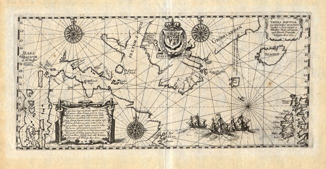
This scarce sea chart of the North Atlantic was created by De Bry after Hessel Gerritz' extremely rare map of 1612. This map shows the track of the fourth and final voyage of Henry Hudson in his hunt for a Northwest Passage, during which he was set adrift after his crew mutinied following a brutal winter and thus was never seen again. There were only eight people from the crew who made it back to England in September of 1611, and with them came the information for this map. This map records Hudson's belief that he had found the Pacific Ocean with the Mare Magnum named at far left; this was later named Hudson Bay. What would become James Bay is shown erroneously with two large bays of its own. A landmark map in the exploration of the North Sea and the Arctic. Adorned with a trio of beautiful compass roses, rhumb lines, a decorative cartouche and the royal crest of Britain.
References: Burden: #165; Kershaw: #55.
Condition: A
Incredibly sharp impression with just two tiny spots of foxing. Light toning in wide, original margins.