Filtered by Category:United States(Show All Categories)
Showing results for:Auction 189
Catalog Archive
167 lots
Page 1 of 4
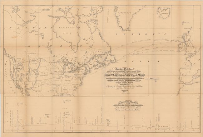
Auction 189, Lot 112
Subject: Canada & United States, Atlantic Ocean
Keefer, Thomas C.
Mercators Projection. With the Great Circle (Shortest Sailing) or Air Lines, Illustrating the Directness & Capacity of the River St. Lawrence from Lake Erie to the Atlantic..., 1855
Size: 34.8 x 22.5 inches (88.4 x 57.2 cm)
Estimate: $300 - $400
Map to Promote Canadian Trade via the St. Lawrence River
Sold for: $170
Closed on 9/14/2022
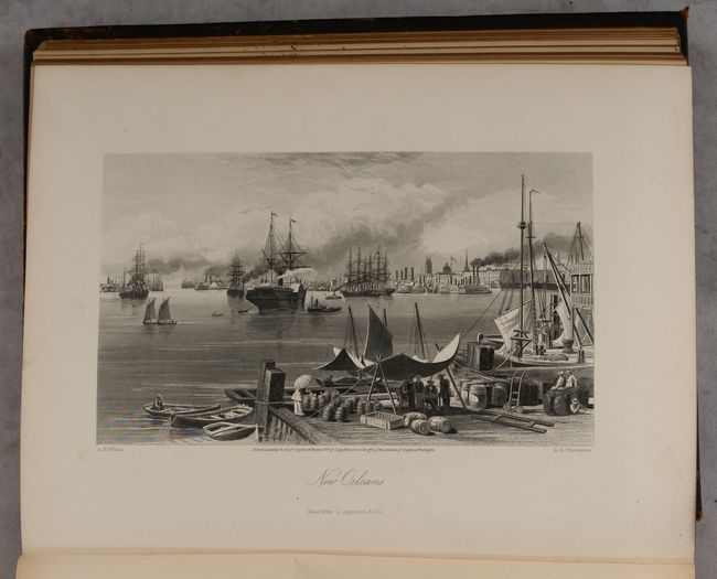
Auction 189, Lot 113
Subject: Canada & United States
Bryant, William C.
[2 Volumes] Picturesque America; or, the Land We Live In..., 1872-74
Size: 10 x 12.8 inches (25.4 x 32.5 cm)
Estimate: $450 - $550
Sold for: $325
Closed on 9/14/2022
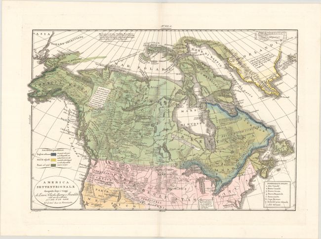
Auction 189, Lot 114
Subject: Canada & Northern United States
Tasso, G.
America Settentrionale Disegnata Dopo i Viaggi di Lewis, Clarke, Parry e Franklin e dall' Atl. di J.A. Buchon..., 1832
Size: 18.4 x 12.3 inches (46.7 x 31.2 cm)
Estimate: $375 - $450
Sold for: $275
Closed on 9/14/2022
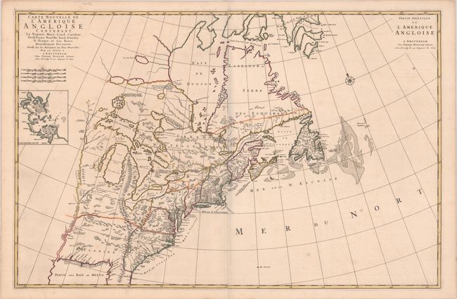
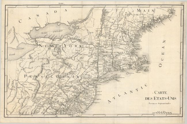
Auction 189, Lot 115
Subject: Colonial Eastern United States & Canada
Mortier, Pierre
Carte Nouvelle de l'Amerique Angloise Contenant la Virginie, Mary-Land, Caroline, Pensylvania Nouvelle Iorck. N: Iarsey N: France, et les Terres Nouvellement Decouerte..., 1700
Size: 35.8 x 23.3 inches (90.9 x 59.2 cm)
Estimate: $2,200 - $2,500
A Map Showing Fascinating Geographic Misconceptions
Sold for: $1,800
Closed on 9/14/2022
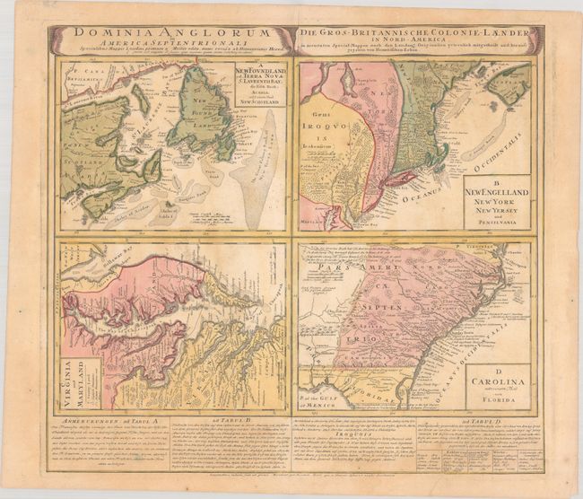
Auction 189, Lot 116
Subject: Colonial Eastern United States & Canada
Homann Heirs
Dominia Anglorum in America Septentrionali... / Die Gros-Britannische Colonie-Laender, in Nord-America..., 1740
Size: 22.1 x 19.9 inches (56.1 x 50.5 cm)
Estimate: $475 - $600
Sold for: $300
Closed on 9/14/2022
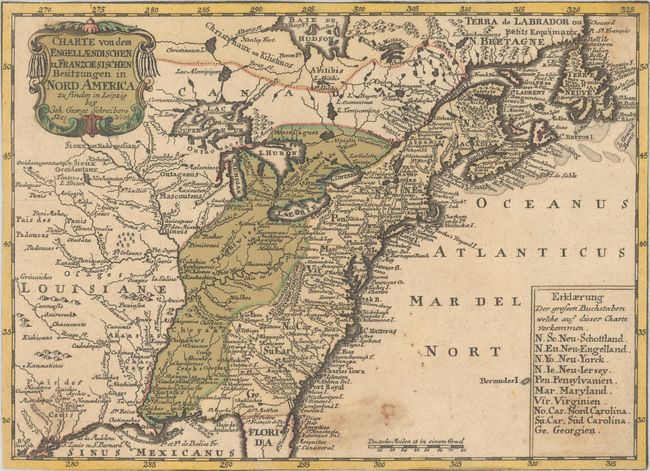
Auction 189, Lot 117
Subject: Colonial Eastern United States & Canada
Schreiber, Johann Georg
Charte von dem Engellaendischen u Franzoesischen Besitzungen in Nord America..., 1753
Size: 9.5 x 6.9 inches (24.1 x 17.5 cm)
Estimate: $350 - $425
Sold for: $250
Closed on 9/14/2022
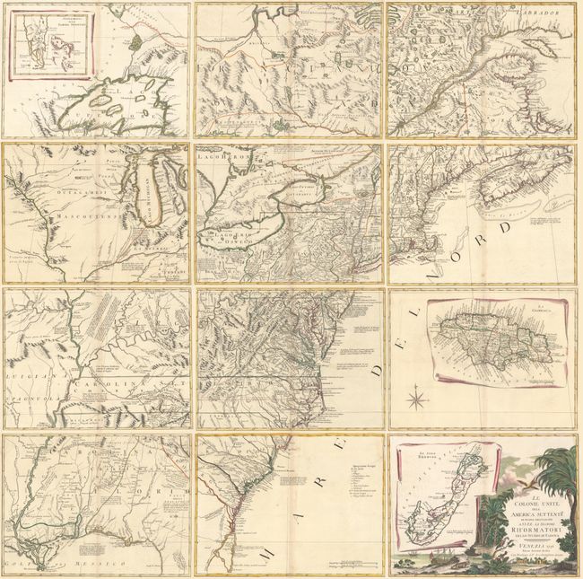
Auction 189, Lot 118
Subject: Colonial Eastern United States & Canada
Zatta, Antonio
[On 12 Sheets] Le Colonie Unite dell' America Settentrle. di Nuova Projezione..., 1778
Size: 16.9 x 12.6 inches (42.9 x 32 cm)
Estimate: $4,750 - $6,000
Impressive 12-Sheet Map of the New "United Colonies"
Sold for: $3,000
Closed on 9/14/2022
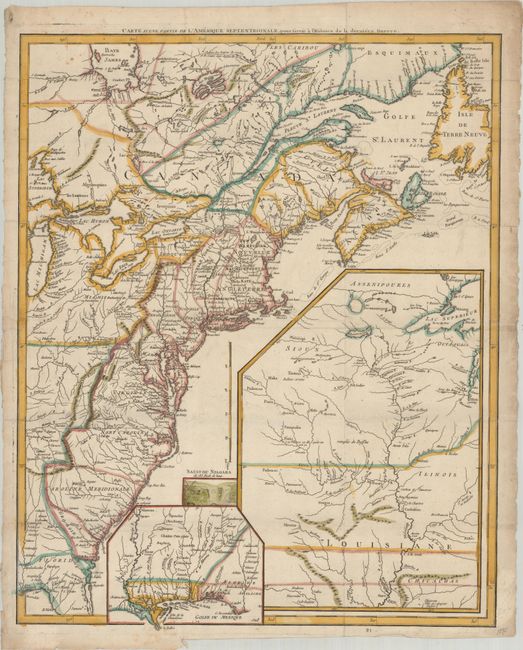
Auction 189, Lot 119
Subject: Eastern United States & Canada
Le Rouge, George Louis
Carte d'une Partie de l'Amerique Septentrionale, pour Servir a l'Histoire de la Derniere Guerre, 1787
Size: 19.4 x 24.1 inches (49.3 x 61.2 cm)
Estimate: $1,000 - $1,300
Sold for: $750
Closed on 9/14/2022
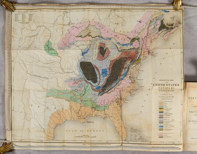
Auction 189, Lot 120
Subject: Eastern United States & Canada, Geology
Lyell, Charles
[Map in Book] Geological Map of the United States Canada &c. Compiled from the State Surveys of the U.S. and Other Sources [in] Travels in North America, in the Years 1841-2; with Geological Observations on the United States..., 1845
Size: 19.6 x 15.3 inches (49.8 x 38.9 cm)
Estimate: $550 - $700
First American Edition of Lyell's Important Account & Geological Map
Sold for: $475
Closed on 9/14/2022
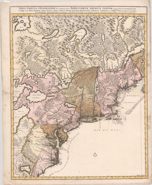
Auction 189, Lot 121
Subject: Colonial Northeastern United States & Canada
Visscher/Schenk
Nova Tabula Geographica Complectens Borealiorem Americae Partem; in qua Exacte Delineatae sunt Canada sive Nova Francia, Nova Scotia, Nova Anglia, Novum Belgium, Pensylvania, Virginia, Carolina, et Terra Nova..., 1717
Size: 18.6 x 23.5 inches (47.2 x 59.7 cm)
Estimate: $1,100 - $1,400
Sold for: $700
Closed on 9/14/2022
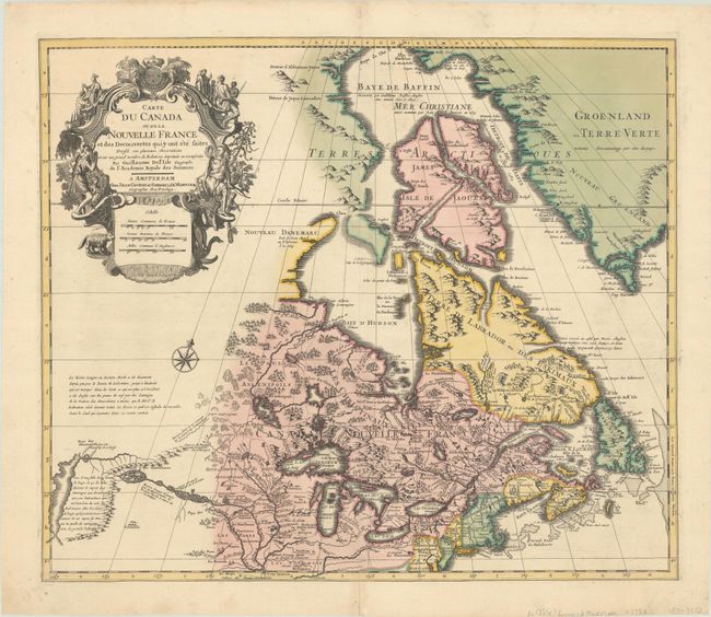
Auction 189, Lot 122
Subject: Colonial Northeastern United States & Canada
Delisle/Covens & Mortier
Carte du Canada ou de la Nouvelle France et des Decouvertes qui y ont ete Faites..., 1730
Size: 22.6 x 19.3 inches (57.4 x 49 cm)
Estimate: $1,400 - $1,700
One of the Most Influential Maps of Canada, Great Lakes & Upper Midwest
Sold for: $900
Closed on 9/14/2022
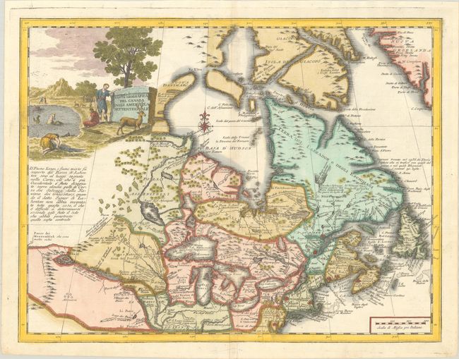
Auction 189, Lot 123
Subject: Colonial Northeastern United States & Canada, Great Lakes
Albrizzi, Girolamo
Carta Geografica del Canada nell' America Settentrionale, 1750
Size: 16.9 x 13 inches (42.9 x 33 cm)
Estimate: $750 - $900
Sold for: $1,200
Closed on 9/14/2022
Auction 189, Lot 124
Subject: Colonial Northeastern United States & Canada, Great Lakes
Robert de Vaugondy, Didier
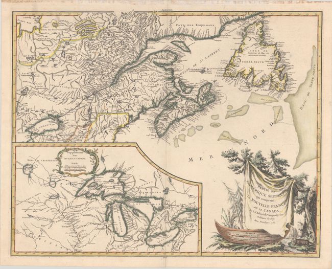
Partie de l'Amerique Septent? qui Comprend la Nouvelle France ou le Canada, 1755
Size: 23.5 x 18.6 inches (59.7 x 47.2 cm)
Estimate: $500 - $650
Sold for: $550
Closed on 9/14/2022
Auction 189, Lot 125
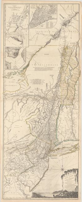
Subject: Colonial Northeastern United States & Quebec
Holland/Pownal
The Provinces of New York and New Jersey; with Part of Pensilvania, and the Province of Quebec, 1776
Size: 21.3 x 52.9 inches (54.1 x 134.4 cm)
Estimate: $3,500 - $4,250
Thomas Jefferys' Important Revolutionary War Period Map
Sold for: $4,000
Closed on 9/14/2022
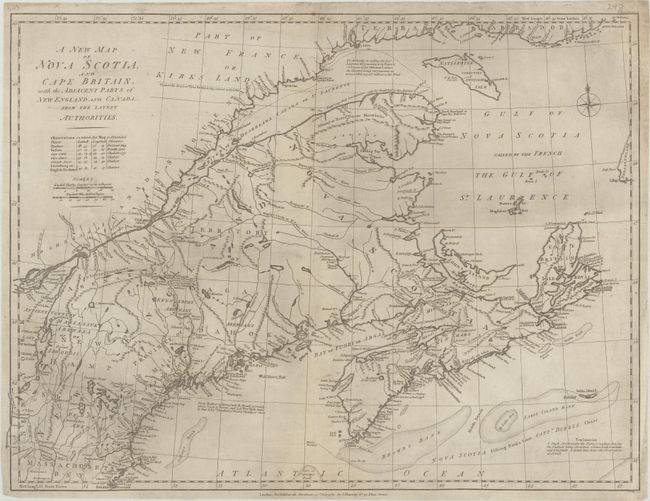
Auction 189, Lot 126
Subject: Northeastern United States & Canada
Murray, John
A New Map of Nova Scotia, and Cape Britain, with the Adjacent Parts of New England and Canada, from the Latest Authorities, 1785
Size: 23.9 x 18 inches (60.7 x 45.7 cm)
Estimate: $375 - $450
Sold for: $325
Closed on 9/14/2022
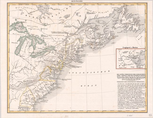
Auction 189, Lot 127
Subject: Northeastern United States & Canada
Petermann, Augustus Herman
[Lot of 2] Die Zwolf Provinzen des Englischen Nord America vor dem Freiheits Kriege... [and] Die Atlantischen Staaten Zwischen Washington & Boston, 1855-79
Size: See Description
Estimate: $60 - $80
NO RESERVE
Sold for: $55
Closed on 9/14/2022
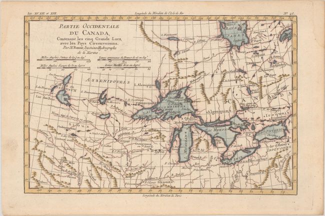
Auction 189, Lot 128
Subject: Colonial Great Lakes
Bonne, Rigobert
Partie Occidentale du Canada, Contenant les Cinq Grands Lacs, avec les Pays Circonvoisins, 1780
Size: 12.5 x 8.2 inches (31.8 x 20.8 cm)
Estimate: $200 - $230
Sold for: $210
Closed on 9/14/2022
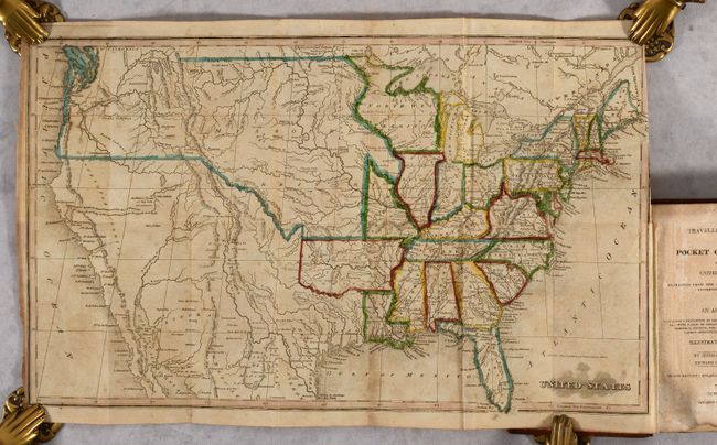
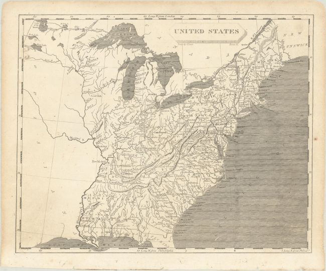
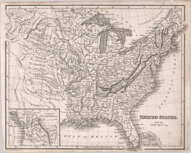
Auction 189, Lot 129
Subject: United States
Morse, Jedidiah (Rev.)
[Map in Book] United States [in] The Traveller's Guide; or Pocket Gazetteer of the United States; Extracted from the Latest Edition of Morse's Universal Gazetteer..., 1826
Size: 16.8 x 10 inches (42.7 x 25.4 cm)
Estimate: $300 - $375
Unsold
Closed on 9/14/2022
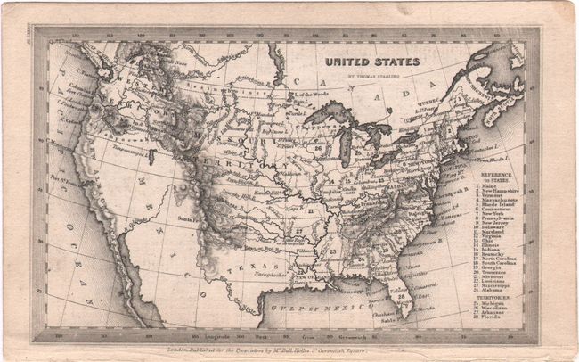
Auction 189, Lot 130
Subject: United States
Starling, Thomas
United States, 1833
Size: 5.8 x 3.6 inches (14.7 x 9.1 cm)
Estimate: $70 - $90
NO RESERVE
Sold for: $50
Closed on 9/14/2022
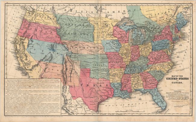
Auction 189, Lot 131
Subject: United States
[Lot of 2] Map of the United States Canada and a Part of Mexico. To Illustrate Olney’s School Geography [and] Map of the United States and Canada, 1844-53
Size: See Description
Estimate: $180 - $220
Sold for: $120
Closed on 9/14/2022
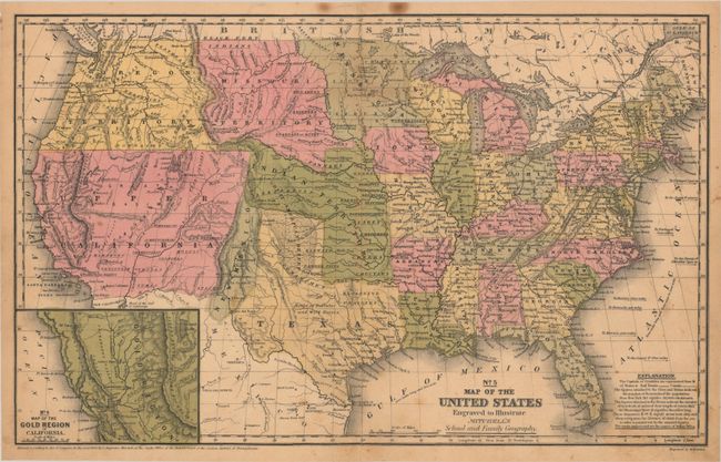
Auction 189, Lot 132
Subject: United States
Mitchell, Samuel Augustus
No. 5 Map of the United States Engraved to Illustrate Mitchell's School and Family Geography, 1849
Size: 16.8 x 10.5 inches (42.7 x 26.7 cm)
Estimate: $200 - $230
Sold for: $120
Closed on 9/14/2022
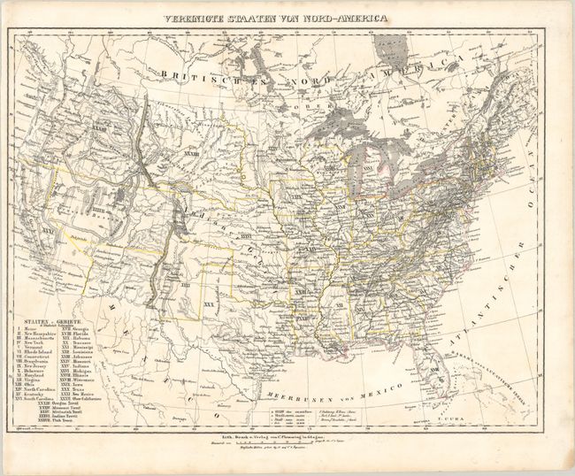
Auction 189, Lot 133
Subject: United States
Flemming, Carl
Vereinigte Staaten von Nord-America, 1850
Size: 16.3 x 12.3 inches (41.4 x 31.2 cm)
Estimate: $160 - $190
Sold for: $120
Closed on 9/14/2022
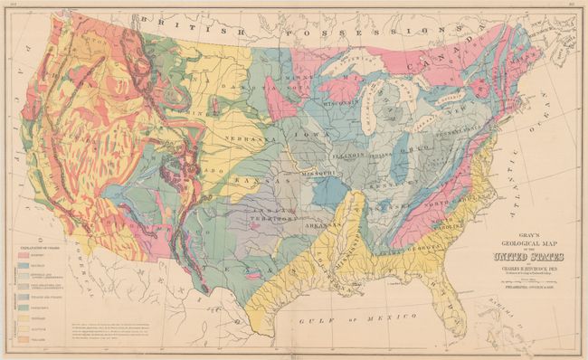
Auction 189, Lot 134
Subject: United States
[Lot of 2] Gray's Geological Map of the United States [and] Geological Map of the United States, 1873-74
Size: See Description
Estimate: $250 - $325
Sold for: $240
Closed on 9/14/2022
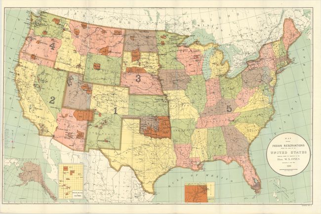
Auction 189, Lot 135
Subject: United States
U.S. Bureau of Indian Affairs
[Lot of 2] Map Showing Indian Reservations Within the Limits of the United States Compiled Under the Direction of the Hon. W.A. Jones... [and] ... Compiled Under the Direction of the Hon. T. J. Morgan..., 1894-1900
Size: See Description
Estimate: $200 - $250
Sold for: $210
Closed on 9/14/2022
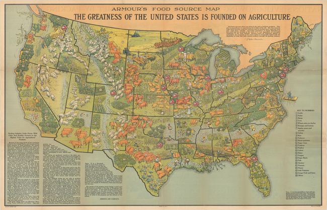
Auction 189, Lot 136
Subject: United States
Armour's Food Source Map, 1922
Size: 39 x 24.9 inches (99.1 x 63.2 cm)
Estimate: $600 - $750
First Edition
Sold for: $475
Closed on 9/14/2022
Auction 189, Lot 137
Subject: United States, Atlases
Pageant of the States, 1938
Size: 12.2 x 9.3 inches (31 x 23.6 cm)
Estimate: $350 - $425
Sold for: $300
Closed on 9/14/2022
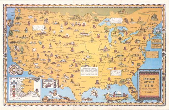
Auction 189, Lot 138
Subject: United States, Native Americans
Indians of the U.S.A., 1944
Size: 33.2 x 20.9 inches (84.3 x 53.1 cm)
Estimate: $400 - $500
Includes Original Guide Sheet
Sold for: $550
Closed on 9/14/2022
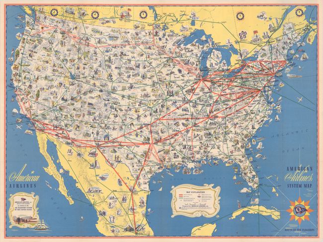
Auction 189, Lot 139
Subject: United States, Aviation
American Airlines System Map - Route of the Flagships, 1945
Size: 31.3 x 23.3 inches (79.5 x 59.2 cm)
Estimate: $100 - $130
NO RESERVE
Sold for: $140
Closed on 9/14/2022
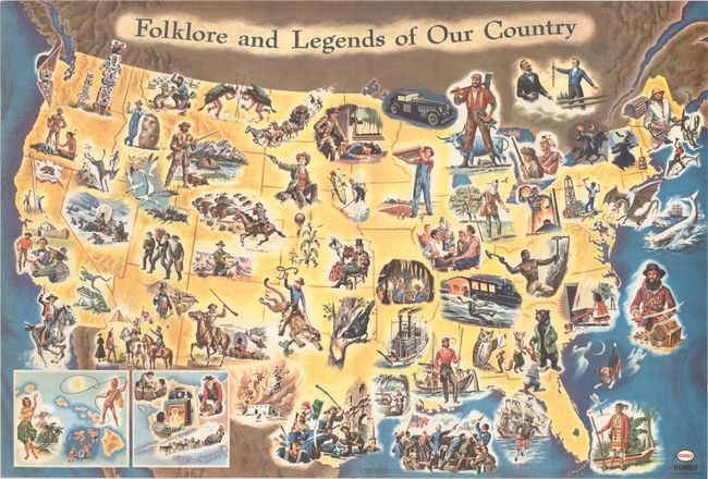
Auction 189, Lot 140
Subject: United States
Folklore and Legends of Our Country, 1962
Size: 33.6 x 22.6 inches (85.3 x 57.4 cm)
Estimate: $160 - $190
Sold for: $120
Closed on 9/14/2022
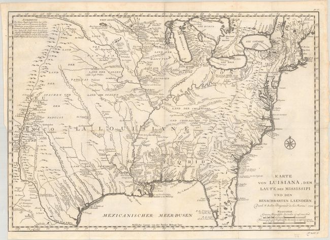
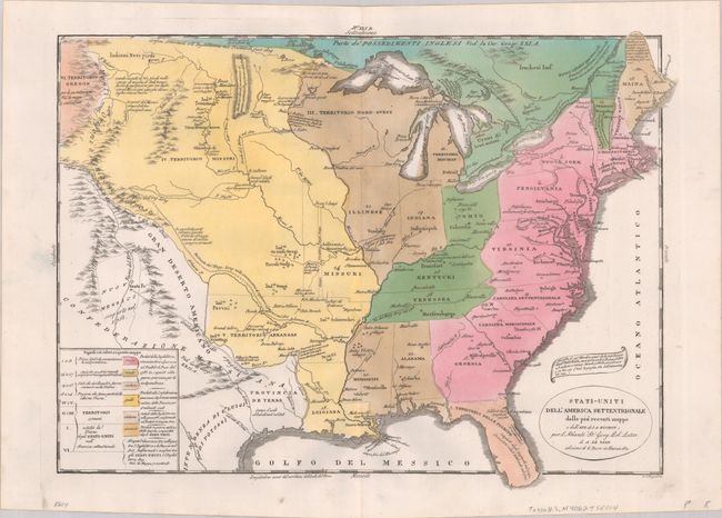
Auction 189, Lot 141
Subject: Colonial Eastern United States
Bellin, Jacques Nicolas
Karte von Luisiana, dem Laufe des Mississipi und den Benachbarten Laendern, 1744
Size: 22.2 x 15.6 inches (56.4 x 39.6 cm)
Estimate: $700 - $850
Sold for: $500
Closed on 9/14/2022
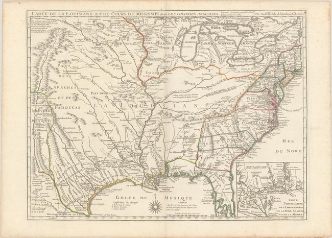
Auction 189, Lot 142
Subject: Colonial Eastern United States, Louisiana Territory
Delisle/Dezauche
Carte de la Louisiane et du Cours du Mississipi avec les Colonies Anglaises, 1782
Size: 25.5 x 19.2 inches (64.8 x 48.8 cm)
Estimate: $1,400 - $1,700
Dezauche Edition of Delisle's Influential Map of the Louisiana Territory
Sold for: $1,000
Closed on 9/14/2022
Auction 189, Lot 143
Subject: Eastern United States
[Lot of 2] United States [and] United States, 1804-32
Size: See Description
Estimate: $160 - $190
NO RESERVE
Unsold
Closed on 9/14/2022
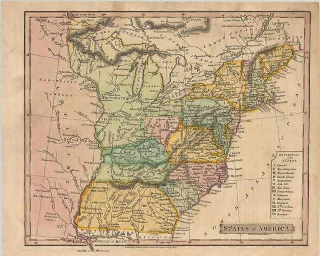
Auction 189, Lot 144
Subject: Eastern United States
Russell, John C.
States of America, 1814
Size: 8.8 x 7.3 inches (22.4 x 18.5 cm)
Estimate: $160 - $190
Sold for: $140
Closed on 9/14/2022
Auction 189, Lot 145
Subject: Eastern United States
Tasso, G.
Stati-Uniti dell' America Settentrionale dalle Piu Recenti Mappe e dall' Atl. di J.A. Buchon..., 1832
Size: 18.1 x 13.7 inches (46 x 34.8 cm)
Estimate: $240 - $300
Sold for: $220
Closed on 9/14/2022
Auction 189, Lot 146
Subject: Eastern United States
[Lot of 2] United States [and] Map of the United States. Engraved for Buckingham's America , 1835-41
Size: See Description
Estimate: $120 - $150
NO RESERVE
Sold for: $50
Closed on 9/14/2022
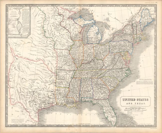
Auction 189, Lot 147
Subject: Eastern United States, Texas
Johnston, Alexander K.
United States and Texas, 1842
Size: 24.3 x 19.8 inches (61.7 x 50.3 cm)
Estimate: $1,200 - $1,500
Scottish Atlas Map Featuring the Independent Republic of Texas
Sold for: $1,700
Closed on 9/14/2022
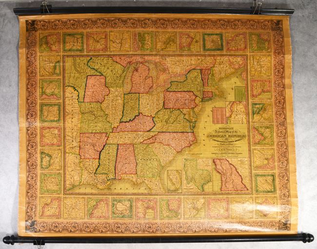
Auction 189, Lot 148
Subject: Eastern United States
Mitchell, Samuel Augustus
Mitchell's National Map of the American Republic or United States of North America, Together with Maps of the Vicinities of Thirty-Two of the Principal Cities and Towns in the Union, 1846
Size: 47 x 38.3 inches (119.4 x 97.3 cm)
Estimate: $950 - $1,200
Sold for: $700
Closed on 9/14/2022
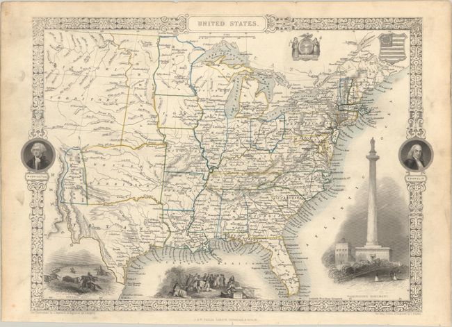
Auction 189, Lot 149
Subject: Eastern United States
Tallis, John
United States, 1850
Size: 13.4 x 9.7 inches (34 x 24.6 cm)
Estimate: $200 - $230
Sold for: $130
Closed on 9/14/2022
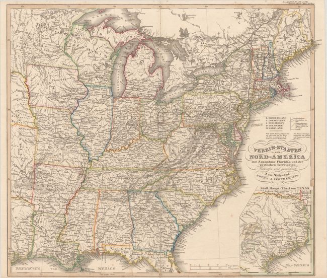
Auction 189, Lot 150
Subject: Eastern United States
Stuelpnagel, Fr von
Verein-Staaten von Nord-America mit Ausnahme Florida's und der Westlichen Territorien, 1852
Size: 15.5 x 13.7 inches (39.4 x 34.8 cm)
Estimate: $160 - $190
Sold for: $140
Closed on 9/14/2022
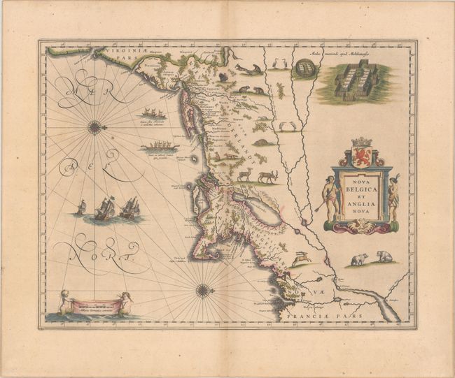
Auction 189, Lot 151
Subject: Colonial New England & Mid-Atlantic United States
Blaeu, Willem
Nova Belgica et Anglia Nova, 1635
Size: 19.9 x 15.3 inches (50.5 x 38.9 cm)
Estimate: $1,900 - $2,200
Important Map of Colonial New England and the Mid-Atlantic in Full Contemporary Color
Sold for: $1,700
Closed on 9/14/2022
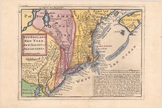
Auction 189, Lot 152
Subject: Colonial New England & Mid-Atlantic United States
Moll, Herman
New England, New York, New Jersey and Pensilvania, 1740
Size: 10.9 x 8.1 inches (27.7 x 20.6 cm)
Estimate: $400 - $475
Sold for: $325
Closed on 9/14/2022
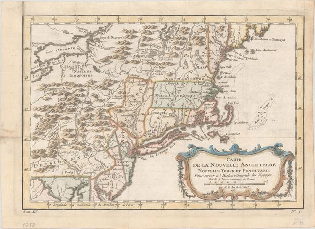
Auction 189, Lot 153
Subject: Colonial New England & Mid-Atlantic United States
Bellin, Jacques Nicolas
Carte de la Nouvelle Angleterre Nouvelle Yorck et Pensilvanie pour Servir a l'Histoire Generale des Voyages, 1757
Size: 11.8 x 8.1 inches (30 x 20.6 cm)
Estimate: $220 - $250
Sold for: $160
Closed on 9/14/2022
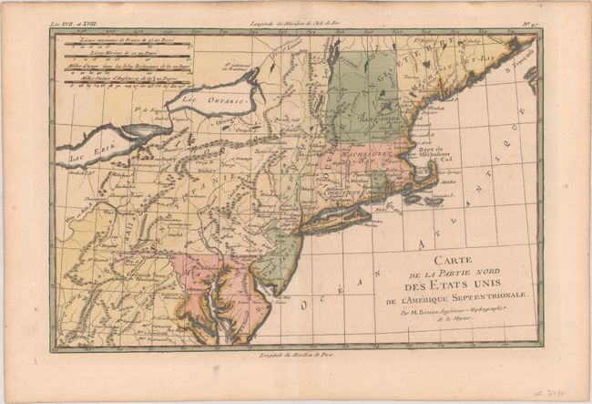
Auction 189, Lot 154
Subject: Colonial New England & Mid-Atlantic United States
Bonne, Rigobert
Carte de la Partie Nord des Etats Unis de l'Amerique Septentrionale, 1780
Size: 12.4 x 8.1 inches (31.5 x 20.6 cm)
Estimate: $140 - $170
Sold for: $100
Closed on 9/14/2022
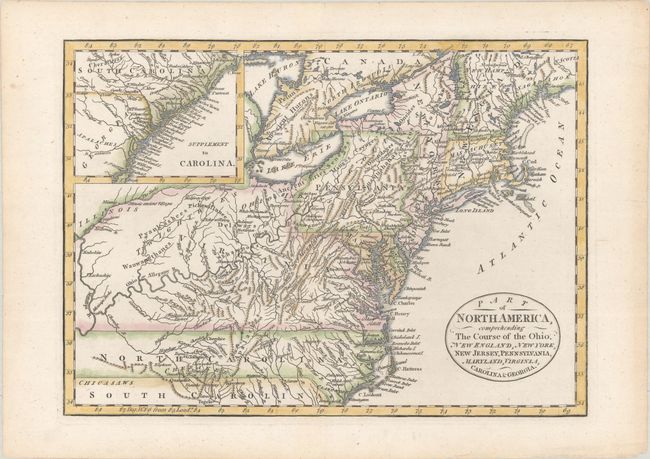
Auction 189, Lot 155
Subject: New England & Mid-Atlantic United States
Cary, John
Part of North America, Comprehending the Course of the Ohio, New England, New York, New Jersey, Pennsylvania, Maryland, Virginia, Carolina & Georgia, 1795
Size: 11.8 x 8.5 inches (30 x 21.6 cm)
Estimate: $325 - $400
Sold for: $200
Closed on 9/14/2022
Auction 189, Lot 156
Subject: New England & Mid-Atlantic United States
Rochefoucald Liancourt, Francois Alexander
Carte des Etats-Unis Provinces Septentrionales, 1799
Size: 20 x 12.7 inches (50.8 x 32.3 cm)
Estimate: $350 - $425
Sold for: $225
Closed on 9/14/2022
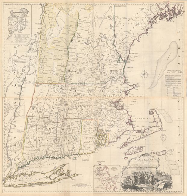
Auction 189, Lot 157
Subject: Colonial New England United States
Jefferys, Thomas
[On 2 Joined Sheets] A Map of the Most Inhabited Part of New England, Containing the Provinces of Massachusets Bay and New Hampshire, with the Colonies of Conecticut and Rhode Island..., 1774
Size: 38.8 x 20.5 inches (98.6 x 52.1 cm)
Estimate: $5,000 - $6,500
Jefferys' Influential Map of New England in Contemporary Outline Color
Sold for: $3,750
Closed on 9/14/2022
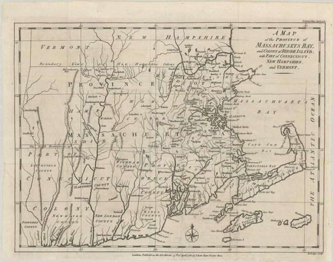
Auction 189, Lot 158
Subject: Colonial New England United States
Lodge, John
A Map of the Province of Massachusets Bay, and Colony of Rhode Island, with Part of Connecticut, New Hampshire, and Vermont, 1782
Size: 14.6 x 10.9 inches (37.1 x 27.7 cm)
Estimate: $750 - $900
Rare Map of Colonial New England
Sold for: $650
Closed on 9/14/2022
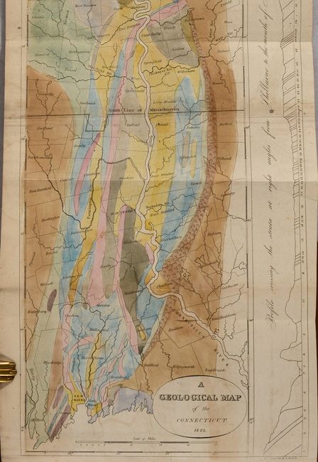
Auction 189, Lot 159
Subject: New England, Connecticut River
Hitchcock, Edward
[Map in Book] A Geological Map of the Connecticut [in] The American Journal of Science, and Arts ... Vol. VI..., 1823
Size: 7.6 x 22 inches (19.3 x 55.9 cm)
Estimate: $160 - $190
Sold for: $160
Closed on 9/14/2022
Auction 189, Lot 160
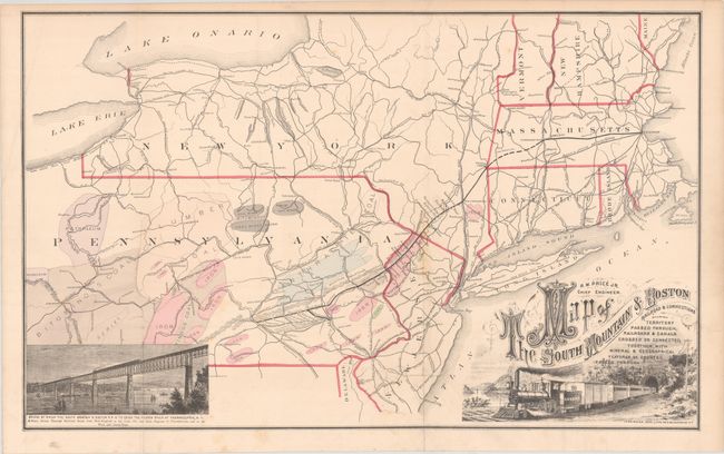
Subject: New England, New York & Pennsylvania
Railroad Companies, (Various)
Map of the South Mountain & Boston Railroad & Connections Showing Territory Passed Through, Railroads & Canals..., 1875
Size: 26.4 x 16.3 inches (67.1 x 41.4 cm)
Estimate: $180 - $220
Sold for: $130
Closed on 9/14/2022
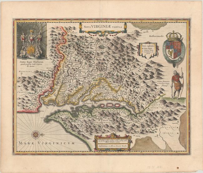
Auction 189, Lot 161
Subject: Colonial Mid-Atlantic United States
Hondius, Henricus
Nova Virginiae Tabula, 1633
Size: 19.6 x 15.1 inches (49.8 x 38.4 cm)
Estimate: $2,000 - $2,300
One of the Most Important 17th Century Maps of the Chesapeake Bay
Sold for: $1,500
Closed on 9/14/2022
167 lots
Page 1 of 4