Subject: United States, Native Americans
Period: 1944 (dated)
Publication:
Color: Printed Color
Size:
33.2 x 20.9 inches
84.3 x 53.1 cm
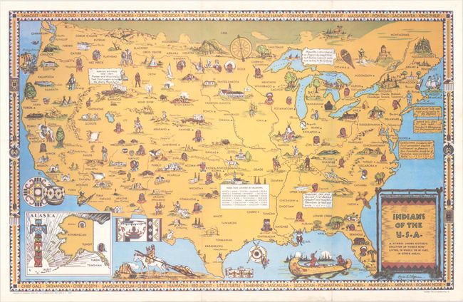
This pictorial map by Louise E. Jefferson shows the location of Native American Indian tribes throughout the United States, also noting the historic locations of tribes that have been displaced. The Trail of Tears is shown, and the map is filled with images of Native American figures, dwellings and artifacts. A few notations are included with historical facts. An inset shows Alaska and a superb totem pole. The map border includes the names of important Native American figures throughout history. Published by Friendship Press, the publishing arm of the National Council of Churches. Friendship Press produced a number of maps of various parts of the world that were designed to promote peace and tolerance. This map was created by artist Louise E. Jefferson, who became the first African American to hold a director position at a publishing firm when she was promoted to Artistic Director at Friendship Press in 1942. Jefferson illustrated numerous books for Friendship Press, including several about race, Africa, and African culture, such as Ethel J. Alpenfels Sense & Nonsense about Race (1938). Included with the map is an original guide sheet on how to use the map, dated 1954.
References: Hornsby (Picturing America) #20; Rumsey #8703.
Condition: A
A bright example, issued folding with minor wear along the folds and light soiling in the bottom margin.