Filtered by Category:United States(Show All Categories)
Showing results for:Auction 184
Catalog Archive
243 lots
Page 1 of 5
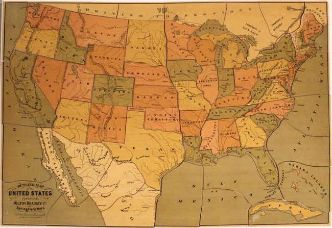
Auction 184, Lot 64
Subject: Cartographic Miscellany, United States Puzzle
Milton Bradley Co.
[Puzzle Map] Outline Map of United States, 1885
Size: 22.1 x 15.4 inches (56.1 x 39.1 cm)
Estimate: $300 - $375
Sold for: $500
Closed on 9/15/2021
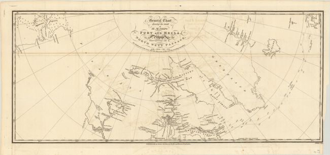
Auction 184, Lot 125
Subject: Canada
Parry, William Edward (Adm. Sir)
General Chart Shewing the Track of H.M. Ships Fury and Hecla, on a Voyage for the Discovery of a North West Passage, AD. 1821-22-23, 1824
Size: 23.8 x 10.1 inches (60.5 x 25.7 cm)
Estimate: $275 - $350
Sold for: $170
Closed on 9/15/2021
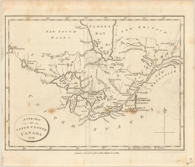
Auction 184, Lot 130
Subject: Eastern Canada, Great Lakes
Stockdale, John
A New Map of Upper & Lower Canada, 1798
Size: 9.1 x 6.9 inches (23.1 x 17.5 cm)
Estimate: $120 - $150
Sold for: $60
Closed on 9/15/2021
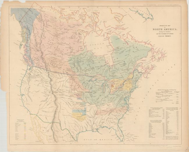
Auction 184, Lot 134
Subject: United States & Canada
Arrowsmith, John
Aboriginal Map of North America, Denoting the Boundaries and the Locations of Various Indian Tribes, 1857
Size: 22.3 x 18.6 inches (56.6 x 47.2 cm)
Estimate: $275 - $350
Sold for: $325
Closed on 9/15/2021
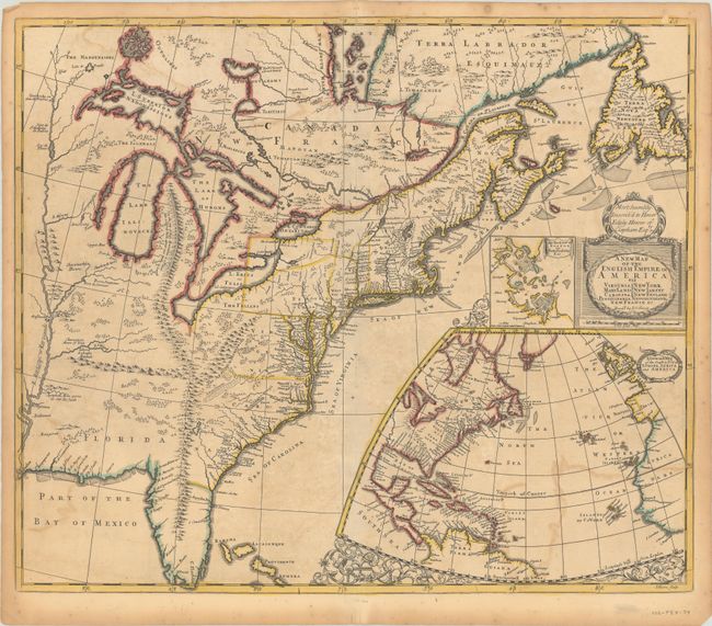
Auction 184, Lot 135
Subject: Colonial Eastern United States & Canada
Senex, John
A New Map of the English Empire in America viz Virginia Maryland Carolina Pennsylvania New York New Iarsey New England Newfoundland New France &c. , 1719
Size: 23.1 x 19.7 inches (58.7 x 50 cm)
Estimate: $2,000 - $2,300
Important Map of the American Colonies
Sold for: $1,500
Closed on 9/15/2021
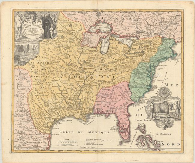
Auction 184, Lot 136
Subject: Colonial Eastern United States & Canada
Homann, Johann Baptist
Amplissimae Regionis Mississipi seu Provinciae Ludovicianae a R.P. Ludovico Hennepin Francisc Miss in America Septentrionali Anno 1687..., 1720
Size: 22.8 x 19.1 inches (57.9 x 48.5 cm)
Estimate: $2,400 - $3,000
Striking Map of Colonial America with Bison Vignette
Sold for: $1,300
Closed on 9/15/2021
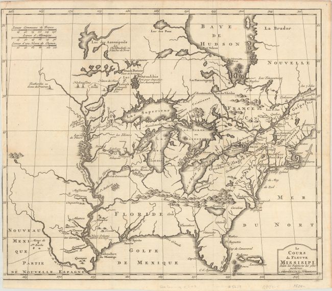
Auction 184, Lot 137
Subject: Colonial Eastern United States & Canada, Great Lakes
Bernard, Jean Frederic
Le Cours du Fleuve Missisipi, Selon les Relations les Plus Modernes, 1737
Size: 17.3 x 14.6 inches (43.9 x 37.1 cm)
Estimate: $1,600 - $1,900
Scarce and Desirable Early Hennepin Variant
Sold for: $1,200
Closed on 9/15/2021
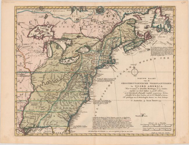
Auction 184, Lot 138
Subject: Colonial Eastern United States & Canada
Tirion, Isaac
Nieuwe Kaart van de Grootbrittannische Volkplantingen in Noord America waar in Tevens de Fransche Bezittingen en de Landen..., 1755
Size: 17.7 x 14.3 inches (45 x 36.3 cm)
Estimate: $600 - $750
Sold for: $450
Closed on 9/15/2021
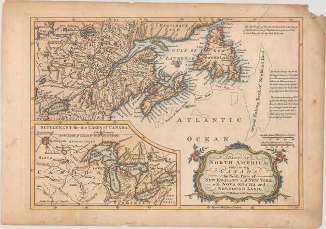
Auction 184, Lot 139
Subject: Colonial Eastern United States & Canada, Great Lakes
Barrow, John (Sir)
Part of North America; Containing Canada, the North Parts of New England and New York; with Nova Scotia and Newfound Land. From the Sr. Robert with Improvements, 1759
Size: 11.5 x 8.1 inches (29.2 x 20.6 cm)
Estimate: $140 - $170
Sold for: $160
Closed on 9/15/2021
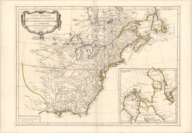
Auction 184, Lot 140
Subject: Colonial Eastern United States & Canada
D'Anville/Santini
Carte Generale du Canada, de la Louisiane, de la Floride, de la Caroline, de la Virginie, de la Nouvelle Angleterre Etc., 1776
Size: 25.8 x 18.8 inches (65.5 x 47.8 cm)
Estimate: $475 - $600
Sold for: $350
Closed on 9/15/2021
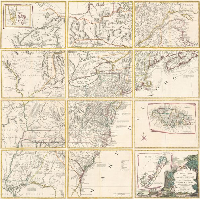
Auction 184, Lot 141
Subject: Colonial Eastern United States & Canada
Zatta, Antonio
[On 12 Sheets] Le Colonie Unite dell' America Settentrle. di Nuova Projezione... , 1778
Size: 16.7 x 12.5 inches (42.4 x 31.8 cm)
Estimate: $4,750 - $6,000
Impressive 12-Sheet Map of the New "United Colonies"
Sold for: $4,500
Closed on 9/15/2021
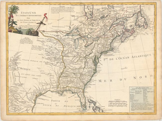
Auction 184, Lot 142
Subject: Eastern United States & Canada
Robert de Vaugondy/Boudet
Etats-Unis de l'Amerique Septentrionale avec les Isles Royale, de Terre Neuve, de St. Jean, l'Acadie &c., 1785
Size: 24.6 x 18.6 inches (62.5 x 47.2 cm)
Estimate: $1,100 - $1,400
First Reference to Michigan as a Land Division of the United States
Sold for: $550
Closed on 9/15/2021
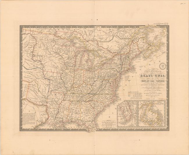
Auction 184, Lot 143
Subject: Eastern United States & Canada, Texas
Brue, Adrien Hubert
Carte Generale des Etats-Unis, des Haut et Bas-Canada, de la Nouvle. Ecosse, du Nouvau. Brunswick, de Terre-Neuve, &a. Seconde Edition, 1843
Size: 20.3 x 14.9 inches (51.6 x 37.8 cm)
Estimate: $180 - $210
Sold for: $130
Closed on 9/15/2021
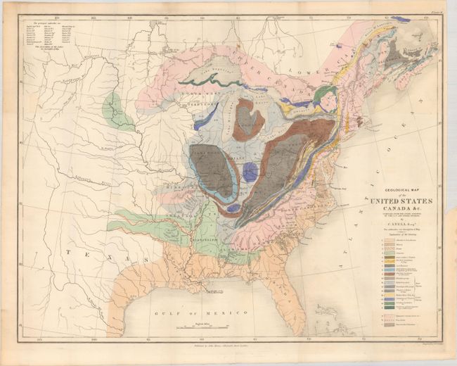
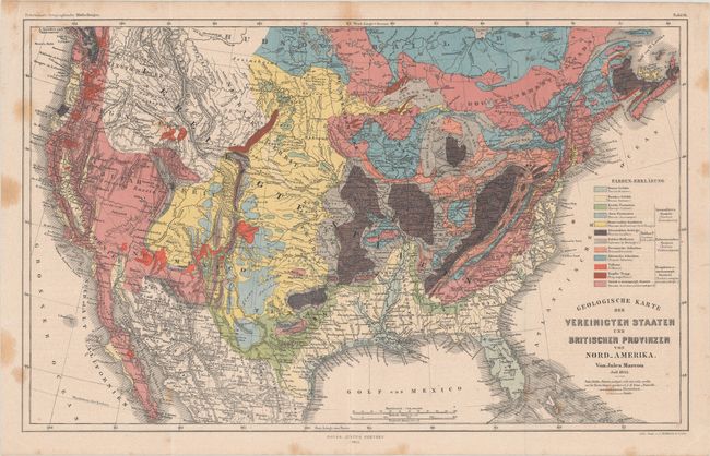
Auction 184, Lot 144
Subject: Eastern United States & Canada, Geology
Lyell, Charles
Geological Map of the United States Canada &c. Compiled from the State Surveys of the U.S. and Other Sources, 1845
Size: 19.7 x 15.3 inches (50 x 38.9 cm)
Estimate: $600 - $750
Unsold
Closed on 9/15/2021
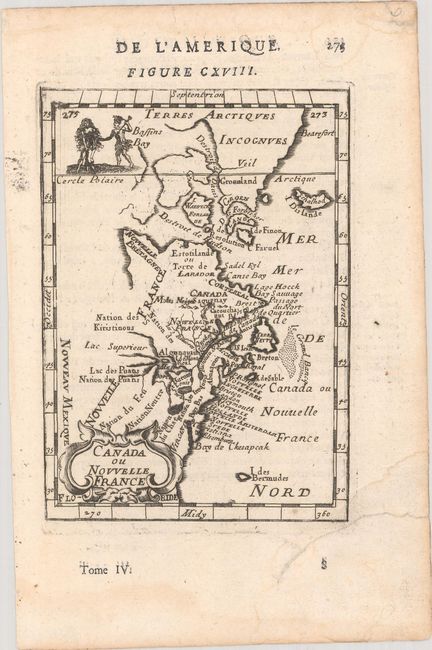
Auction 184, Lot 145
Subject: Colonial Northeastern United States & Canada
[Lot of 2] Canada ou Nouvelle France [and] Carte de la Partie de l'Amerique Septentrionale qui Comprend les Possessions Anglaises, 1683-1782
Size: See Description
Estimate: $240 - $300
Sold for: $135
Closed on 9/15/2021
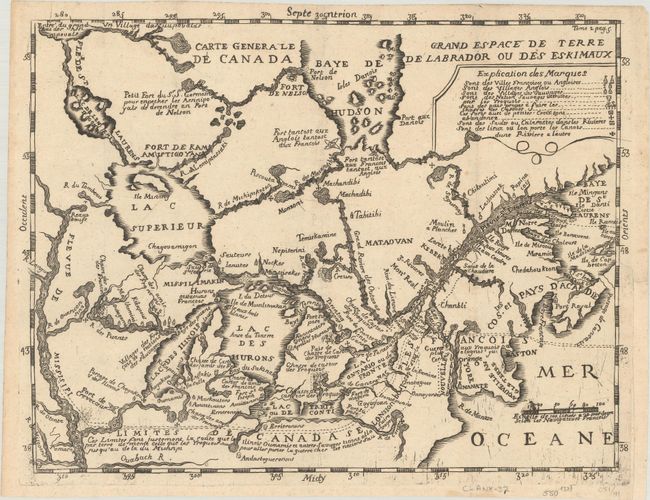
Auction 184, Lot 146
Subject: Colonial Northeastern United States & Canada, Great Lakes
Lahontan, Louis Armand, Baron de
Carte Generale de Canada / Grand Espace de Terre de Labrador ou des Eskimaux, 1703
Size: 11.9 x 9.3 inches (30.2 x 23.6 cm)
Estimate: $1,000 - $1,300
Smaller Edition of Lahontan's Map of Canada and the Great Lakes
Sold for: $550
Closed on 9/15/2021
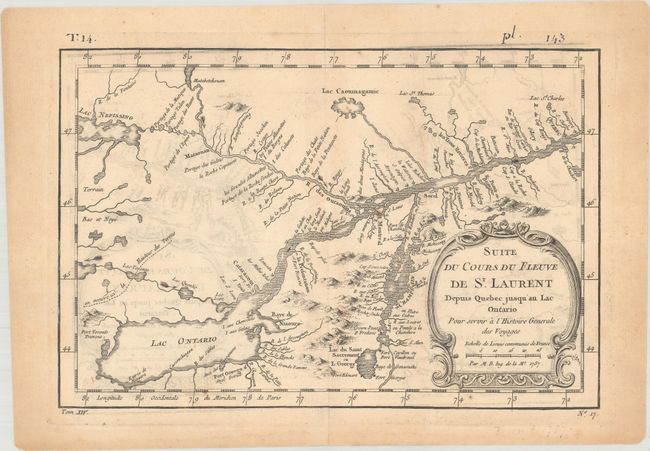
Auction 184, Lot 147
Subject: Colonial Northeastern United States & Canada, Great Lakes
[Lot of 3] Suite du Cours du Fleuve de St. Laurent Depuis Quebec Jusqu'au Lac Ontario... [and] Plan of the Forts Ontario and Oswego... [and] Charte der Neuen Niederlassungen in Ober Canada nach der Smythschen Charte, 1757-1814
Size: See Description
Estimate: $275 - $350
Sold for: $160
Closed on 9/15/2021
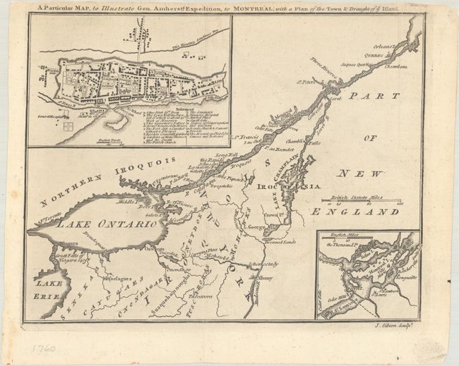
Auction 184, Lot 148
Subject: Colonial Northeastern United States & Canada, Montreal
Gibson, John
A Particular Map, to Illustrate Gen. Amherst's Expedition, to Montreal; with a Plan of the Town & Draught of ye Island, 1760
Size: 9 x 7 inches (22.9 x 17.8 cm)
Estimate: $140 - $170
Sold for: $100
Closed on 9/15/2021
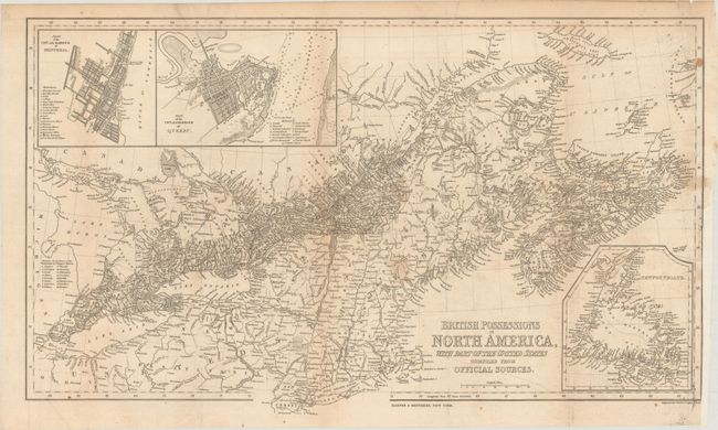
Auction 184, Lot 149
Subject: Northeastern United States & Canada
Harper Bros.
British Possessions in North America, with Part of the United States Compiled from Official Sources, 1843
Size: 24.4 x 14.5 inches (62 x 36.8 cm)
Estimate: $160 - $190
Sold for: $90
Closed on 9/15/2021
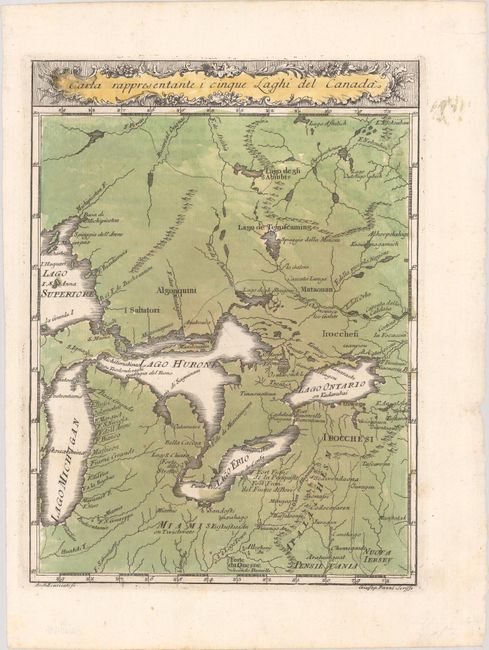
Auction 184, Lot 150
Subject: Colonial Central United States & Canada, Great Lakes
Pazzi, Giuseppe
Carta Rappresentante i Cinque Laghi del Canada, 1763
Size: 7.4 x 10 inches (18.8 x 25.4 cm)
Estimate: $350 - $425
Sold for: $180
Closed on 9/15/2021
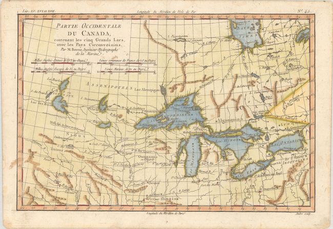
Auction 184, Lot 151
Subject: Colonial Central United States & Canada, Great Lakes
Bonne, Rigobert
Partie Occidentale du Canada, Contenant les Cinq Grands Lacs, avec les Pays Circonvoisins, 1775
Size: 12.7 x 8.5 inches (32.3 x 21.6 cm)
Estimate: $200 - $230
Sold for: $150
Closed on 9/15/2021
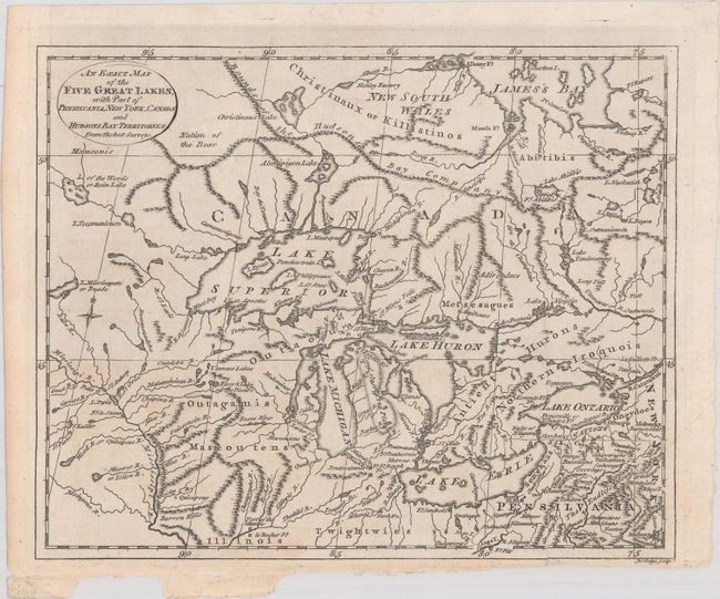
Auction 184, Lot 152
Subject: Colonial Central United States & Canada, Great Lakes
Lodge, John
An Exact Map of the Five Great Lakes, with Part of Pensilvania, New York, Canada and Hudsons Bay Territories. From the Best Surveys, 1778
Size: 10.1 x 8.1 inches (25.7 x 20.6 cm)
Estimate: $325 - $400
Sold for: $375
Closed on 9/15/2021
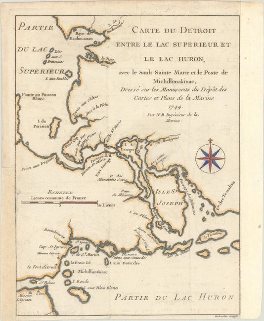
Auction 184, Lot 153
Subject: Colonial Great Lakes
Bellin, Jacques Nicolas
Carte du Detroit entre le Lac Superieur et le Lac Huron, avec le Sault Sainte Marie et le Poste de Michillimakinac…, 1744
Size: 6.2 x 8.2 inches (15.7 x 20.8 cm)
Estimate: $275 - $350
Sold for: $300
Closed on 9/15/2021
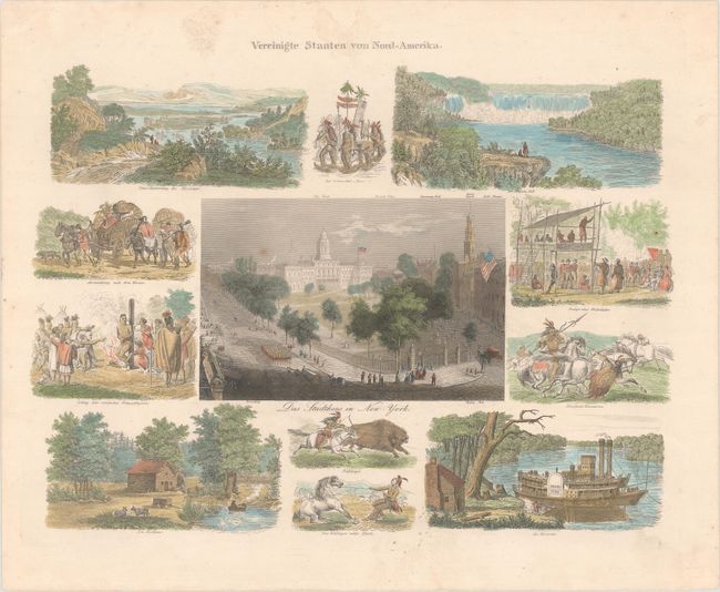
Auction 184, Lot 154
Subject: United States & Canada, Natives Americans
Vereinigte Staaten von Nord-Amerika, 1845
Size: 14 x 10.2 inches (35.6 x 25.9 cm)
Estimate: $140 - $170
Sold for: $200
Closed on 9/15/2021
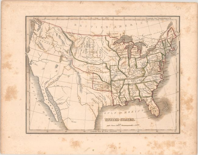
Auction 184, Lot 155
Subject: United States
Bradford, Thomas Gamaliel
United States, 1835
Size: 10.1 x 7.6 inches (25.7 x 19.3 cm)
Estimate: $80 - $100
NO RESERVE
Sold for: $210
Closed on 9/15/2021
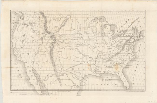
Auction 184, Lot 156
Subject: United States, Railroads
Throop, O. H.
[Untitled - Map of Proposed Routes of Western Railroads], 1846
Size: 15.9 x 10 inches (40.4 x 25.4 cm)
Estimate: $160 - $190
Sold for: $275
Closed on 9/15/2021
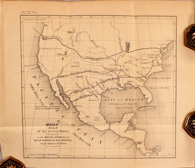
Auction 184, Lot 157
Subject: United States
U.S. Government
[Map in Report] Mills' Map of the Several Routes Proposed to the Pacific Ocean from the Head Waters of the Missouri, to the Isthmus of Darien [in] Memorial of Robert Mills, Respecting a New Route to the Pacific Ocean..., 1848
Size: 9 x 8.2 inches (22.9 x 20.8 cm)
Estimate: $140 - $170
Sold for: $100
Closed on 9/15/2021
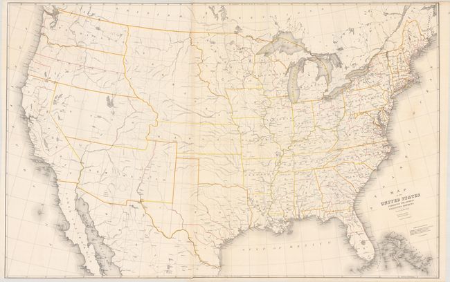
Auction 184, Lot 158
Subject: United States
Burr, David H.
Map of the United States Exhibiting the Several Collection Districts, 1854
Size: 49.3 x 31.4 inches (125.2 x 79.8 cm)
Estimate: $275 - $350
Sold for: $200
Closed on 9/15/2021
Auction 184, Lot 159
Subject: United States, Geology
Marcou, Jules
Geologische Karte der Vereinicten Staaten und Britischen Provinzen von Nord_Amerika, 1855
Size: 15 x 9.5 inches (38.1 x 24.1 cm)
Estimate: $220 - $250
Sold for: $210
Closed on 9/15/2021
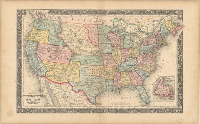
Auction 184, Lot 160
Subject: United States
Mitchell, Samuel Augustus
Map of the United States, and Territories. Together with Canada &c., 1860
Size: 21.3 x 13.1 inches (54.1 x 33.3 cm)
Estimate: $200 - $230
Sold for: $475
Closed on 9/15/2021
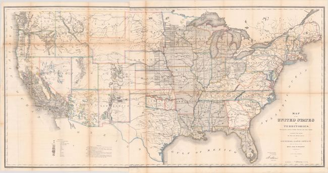
Auction 184, Lot 161
Subject: United States
General Land Office
Map of the United States and Territories, Shewing the Extent of Public Surveys and Other Details... [with] Vericht des Commissionar des General-Landamtes, der Vereinigten Staaten von Amerika..., 1867
Size: 55.4 x 28 inches (140.7 x 71.1 cm)
Estimate: $300 - $375
Sold for: $275
Closed on 9/15/2021
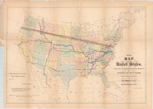
Auction 184, Lot 162
Subject: United States
Maury, M. F.
Plate III. Map of the United States. Constructed on the Rectangular Tangential Projection..., 1868
Size: 26.4 x 18.2 inches (67.1 x 46.2 cm)
Estimate: $240 - $300
Rare First State
Sold for: $325
Closed on 9/15/2021
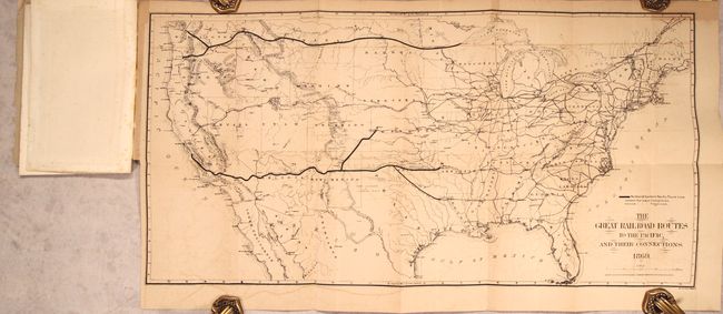
Auction 184, Lot 163
Subject: United States
Gorlinski, Joseph
The Great Railroad Routes to the Pacific, and Their Connections [in report] The Policy of Extending Government Aid to Additional Railroads to the Pacific..., 1869
Size: 27.5 x 14 inches (69.9 x 35.6 cm)
Estimate: $275 - $350
Sold for: $220
Closed on 9/15/2021
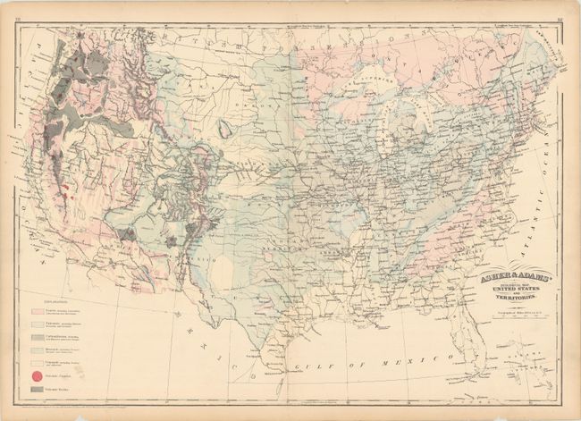
Auction 184, Lot 164
Subject: United States
Asher & Adams
Asher & Adams' Geological Map. United States and Territories, 1872
Size: 23.3 x 16 inches (59.2 x 40.6 cm)
Estimate: $100 - $130
Sold for: $75
Closed on 9/15/2021
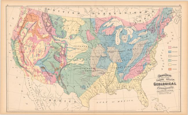
Auction 184, Lot 165
Subject: United States, Geology
Hitchcock, Charles Henry
Gray's Atlas Map of the United States Showing the Principal Geological Formations, 1874
Size: 26.5 x 16.2 inches (67.3 x 41.1 cm)
Estimate: $110 - $140
Sold for: $150
Closed on 9/15/2021
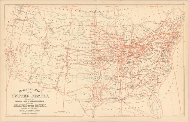
Auction 184, Lot 166
Subject: United States, Railroads
Mitchell, Samuel Augustus
Railroad Map of the United States, Showing the Through Lines of Communication from the Atlantic to the Pacific. Together with the Various Steamship Lines Along the Seaboard, 1880
Size: 22.8 x 14.4 inches (57.9 x 36.6 cm)
Estimate: $70 - $90
NO RESERVE
Sold for: $230
Closed on 9/15/2021
Auction 184, Lot 167
Subject: United States, Geology
U.S. Geological Survey (USGS)
Map of the United States Exhibiting the Present Status of Knowledge Relating to the Areal Distribution of Geologic Groups (Preliminary Compilation), 1884
Size: 28.2 x 17.4 inches (71.6 x 44.2 cm)
Estimate: $140 - $170
Sold for: $80
Closed on 9/15/2021
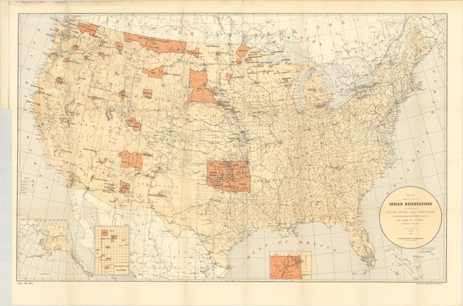
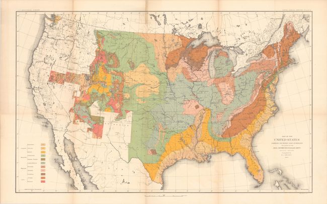
Auction 184, Lot 168
Subject: United States, Native Americans
U.S. Government
[Map with Report] Map Showing the Location of the Indian Reservations Within the Limits of the United States and Territories... [with] Seventeenth Annual Report of the Board of Indian Commissioners, the Year 1885, 1886
Size: 33.5 x 21 inches (85.1 x 53.3 cm)
Estimate: $120 - $150
Sold for: $220
Closed on 9/15/2021
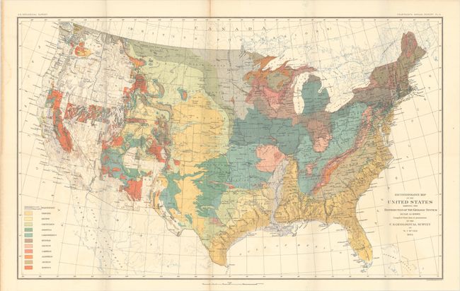
Auction 184, Lot 169
Subject: United States, Geology
U.S. Geological Survey (USGS)
Reconnoissance Map of the United States Showing the Distribution of the Geologic System So Far as Known... [in] Fourteenth Annual Report of the Director of the Untied States Geological Survey..., 1893
Size: 28.2 x 17.5 inches (71.6 x 44.5 cm)
Estimate: $300 - $375
Sold for: $150
Closed on 9/15/2021
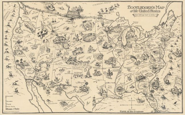
Auction 184, Lot 170
Subject: United States
Bootlegger's Map of the United States, 1926
Size: 33.9 x 21.3 inches (86.1 x 54.1 cm)
Estimate: $1,400 - $1,700
McCandlish's Humorous Prohibition Map
Sold for: $900
Closed on 9/15/2021
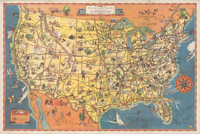
Auction 184, Lot 171
Subject: United States
A Good-Natured Map of the United States Setting Forth the Services of the Greyhound Lines and a Few Principal Connecting Bus Lines, 1935
Size: 28.9 x 19.1 inches (73.4 x 48.5 cm)
Estimate: $200 - $230
Sold for: $210
Closed on 9/15/2021
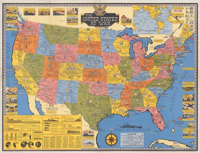
Auction 184, Lot 172
Subject: United States, World War II
Turner, Stanley
The United States at War, 1943
Size: 25.9 x 19.7 inches (65.8 x 50 cm)
Estimate: $300 - $375
Sold for: $240
Closed on 9/15/2021
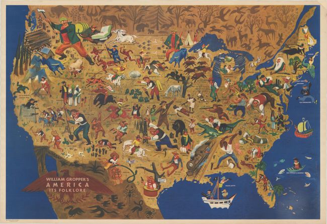
Auction 184, Lot 173
Subject: United States
William Gropper's America Its Folklore, 1946
Size: 32.7 x 22.3 inches (83.1 x 56.6 cm)
Estimate: $1,500 - $1,800
Map by Artist Blacklisted During McCarthy Era
Sold for: $1,700
Closed on 9/15/2021
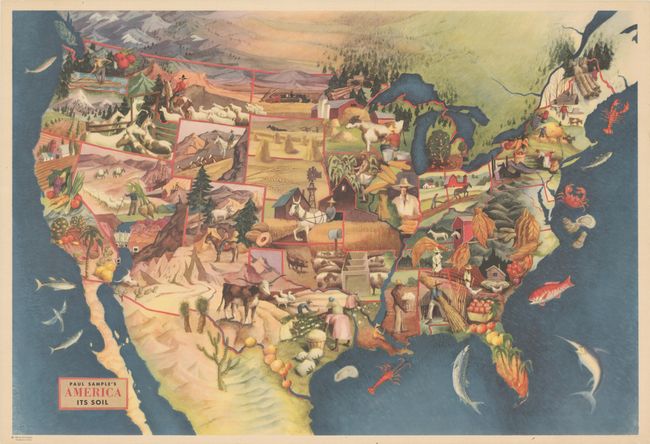
Auction 184, Lot 174
Subject: United States
Paul Sample's America Its Soil, 1946
Size: 32.8 x 22.3 inches (83.3 x 56.6 cm)
Estimate: $650 - $800
Sold for: $750
Closed on 9/15/2021
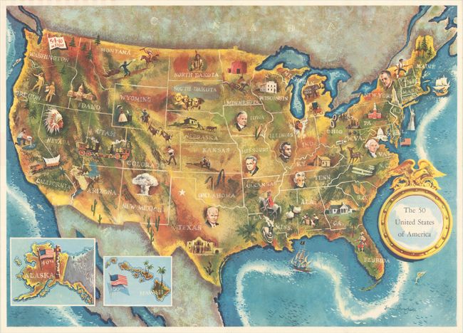
Auction 184, Lot 175
Subject: United States, Presidential Elections
The 50 United States of America, 1960
Size: 24.9 x 17.9 inches (63.2 x 45.5 cm)
Estimate: $200 - $230
Sold for: $120
Closed on 9/15/2021
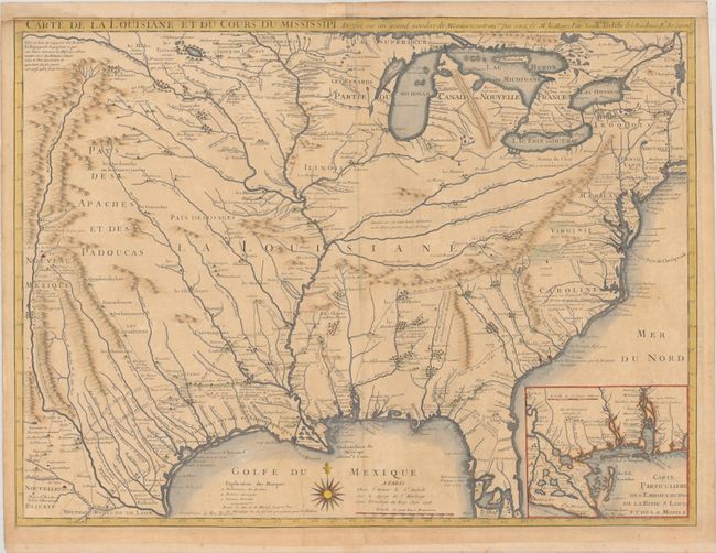
Auction 184, Lot 176
Subject: Colonial Eastern United States
Delisle, Guillaume
Carte de la Louisiane et du Cours du Mississipi Dressee sur un Grand Nombre de Memoires Entrautres sur ceux de Mr. le Maire, 1718
Size: 25.6 x 19.1 inches (65 x 48.5 cm)
Estimate: $5,500 - $7,000
A Foundation Map for the Mississippi Valley and the First Appearance of Texas on a Printed Map - First State
Sold for: $4,000
Closed on 9/15/2021
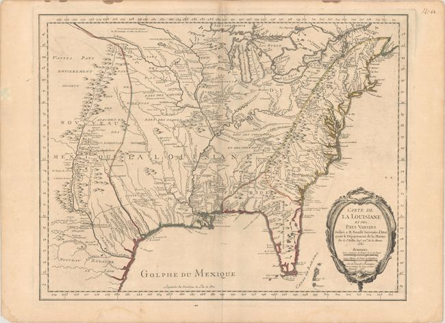
Auction 184, Lot 177
Subject: Colonial Eastern United States
Bellin, Jacques Nicolas
Carte de la Louisiane et des Pays Voisins Dediee a M. Rouille Secretaire d'Etat, Ayant le Departement de la Marine, 1755
Size: 24.1 x 18.8 inches (61.2 x 47.8 cm)
Estimate: $1,400 - $1,700
Bellin's Scarce French and Indian War-Era Map of the Colonial United States
Unsold
Closed on 9/15/2021
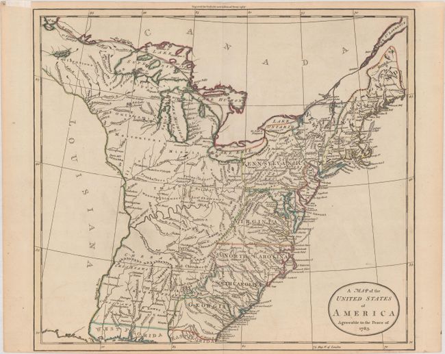
Auction 184, Lot 178
Subject: Eastern United States
Guthrie, William
A Map of the United States of America Agreeable to the Peace of 1783, 1786
Size: 15.6 x 13.9 inches (39.6 x 35.3 cm)
Estimate: $475 - $600
Sold for: $350
Closed on 9/15/2021
Auction 184, Lot 179
Subject: Eastern United States
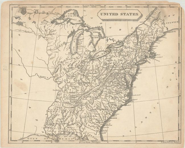
[Lot of 2] United States [and] United States, 1804-15
Size: See Description
Estimate: $230 - $275
NO RESERVE
Unsold
Closed on 9/15/2021
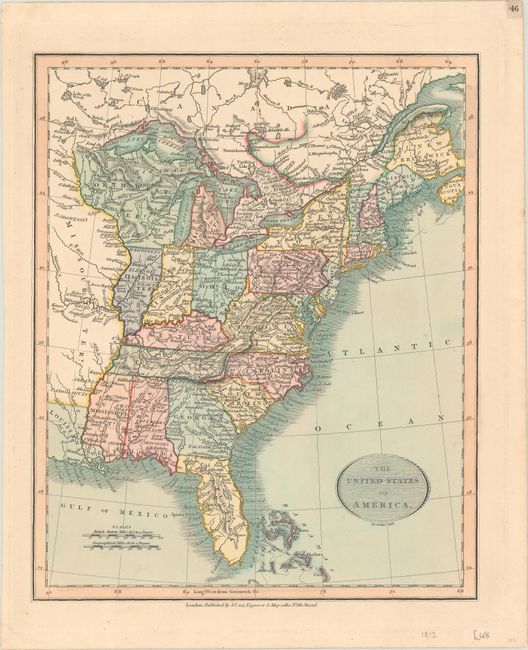
Auction 184, Lot 180
Subject: Eastern United States
Cary, John
The United States of America, 1819
Size: 9.1 x 11.1 inches (23.1 x 28.2 cm)
Estimate: $200 - $230
Sold for: $375
Closed on 9/15/2021
243 lots
Page 1 of 5