Subject: Colonial Eastern United States
Period: 1755 (dated)
Publication:
Color: Hand Color
Size:
24.1 x 18.8 inches
61.2 x 47.8 cm
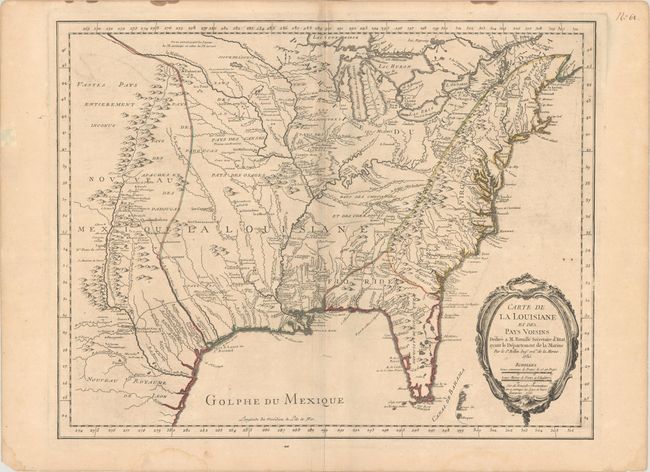
This scarce French and Indian War-era map covers the region from the Great Lakes to Florida, and from the eastern seaboard west to Santa Fe. It is a later state of the map originally published in Bellin's Atlas Maritime in 1750, with up-to-date territorial holdings and improved cartography around the Great Lakes region, as indicated by a note under the distance scales in the title cartouche. The cartography is based on Guillaume Delisle's landmark map of 1718, with additional information from French Jesuit historian and traveler Pierre Francois Xavier Charlevoix and other French explorers. It shows the English colonies confined to east of the Appalachians, Spain in control of Florida, and the French in control of the Mississippi River Basin. Several forts are identified, including the destroyed Fort Necessity, site of one of the first battles of the French and Indian War and the only surrender of George Washington's military career.
References: Lowery #406; McCorkle #755.3; MCC-96 #689.
Condition: B+
A nice impression on a sheet with the watermark of a Maltese cross encircled in rosary beads. There is light toning that is a bit more apparent along the centerfold, minor offsetting, and light dampstains that are confined to the blank margins.