Subject: United States
Period: 1868 (dated)
Publication: Physical Survey of Virginia
Color: Hand Color
Size:
26.4 x 18.2 inches
67.1 x 46.2 cm
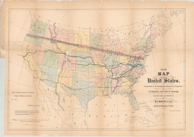
This detailed map of the United States was issued shortly after the conclusion of the Civil War and was published in Maury's Physical Survey of Virginia. In 1868 General Francis Smith, Superintendent of the Virginia Military Institute, convinced Maury to return to Virginia (from England) to become a Physics professor and produce a "Physical Survey of Virginia." The survey was intended to aid in Virginia's recovery from the Civil War with the goal of developing "the physical resources of the State, to make known its geography, and to point out the great commercial advantages which naturally arise from its situation with regard to the sea and the interior."
This map of the United States shows how Virginia was well positioned to serve as a commercial center for transporting goods from the Atlantic Ocean to the Pacific Ocean and the Gulf of Mexico. Railroad lines, both completed and under construction, are shown extending from Virginia to the West Coast. Major waterways are highlighted in blue to offer additional methods of transport. The map also includes a line of equi-distance between Norfolk and New York extending to the Pacific -- another visual effect to encourage trade to flow through Virginia's rivers and railroads. Drawn by J.H. Waddell under the instructions of M.F. Maury, LLD, Prof. of Physics, Virginia Military Institute. This is the very rare first state of this map, which was lithographed by A. Hoen & Co. in Baltimore. There is a later state of this map that no longer includes the A. Hoen & Co. imprint, and has additional changes to the map, including the addition of a northern route to the Pacific ending in Washington State, the Atlantic & Pacific Railroad extending through Oklahoma, and the locations of gold, silver, and copper mines. The later state of the map is also found in 1868 editions of the report, yet we were not able to determine exactly when or why the map was changed during the same year. The report is not included with this lot.
Matthew Fontaine Maury (1806-73) was Superintendent of the U.S. Naval Observatory from 1842-1861. In 1855 he published his Physical Geography of the Sea, which was the first comprehensive book on oceanography. Prior to his role at VMI (1868-73), Maury was a Commander in the Confederate Navy.
References:
Condition: B
Issued folding, now flattened, with a few spots of foxing. There are numerous fold separations that have been closed on verso with archival material, as well as small areas of loss along the folds, most notably just north of Colorado. Several short tears have also been closed on verso with archival materials.