Subject: Eastern United States
Period: 1786 (published)
Publication: Guthrie's New System of Geography
Color: Hand Color
Size:
15.6 x 13.9 inches
39.6 x 35.3 cm
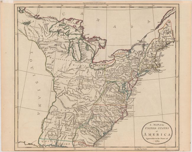
This early map depicts the young United States following the Treaty of Paris. The map shows New York and Pennsylvania both bordering Lake Ontario. In the far northeast the territory of Sagahadok is a large region above the barely mentioned Main. Lake Superior is unapologetically filled with fictitious islands. The region west of the Mississippi River is completely blank with no features, but good detail is provided along its east side including several named Indian villages. It is interesting that the map locates none of the Revolutionary War Bounty Land Grants. There is good detail east of the Appalachian mountains, but the region between the mountains, the Mississippi River and the Canadian border contain no named regions but it is filled with Indian lands, forts, small towns and villages, and gives good watershed detail. Curiously, Detroit is not located. The map just extends to the northern portion of Florida which is divided into east and west regions. Under the control of Spain, Florida had been ceded by England to the Spanish in gratitude for their neutrality during the American Revolutionary War. Engraved by Wm. Darton of Tottenham. Blank verso.
References: Shirley (BL Atlases) T.GUTH-6a #21; McCorkle (Geography Books) #183-21
Condition: A
A nice impression with contemporary outline color on a sheet with a fleur-de-lis watermark and a hint of offsetting at bottom left. Very narrow bottom margin due to being trimmed by bookbinder. There is minor toning along the edges of the sheet, entering the map border a bit a bottom. Remnants of hinge tape on recto and verso.