Filtered by Category:United States(Show All Categories)
Showing results for:Auction 168
Catalog Archive
203 lots
Page 1 of 5
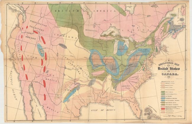
Auction 168, Lot 123
Subject: United States & Canada, World
Hitchcock, Edward
[Maps with Report] A Geological Map of the United States and Canada [and] Outline of the Geology of the Globe, 1856
Size: 5.5 x 8.7 inches (14 x 22.1 cm)
Estimate: $1,000 - $1,300
Includes Hitchcock's First Geological Map of the United States
Sold for: $750
Closed on 6/6/2018
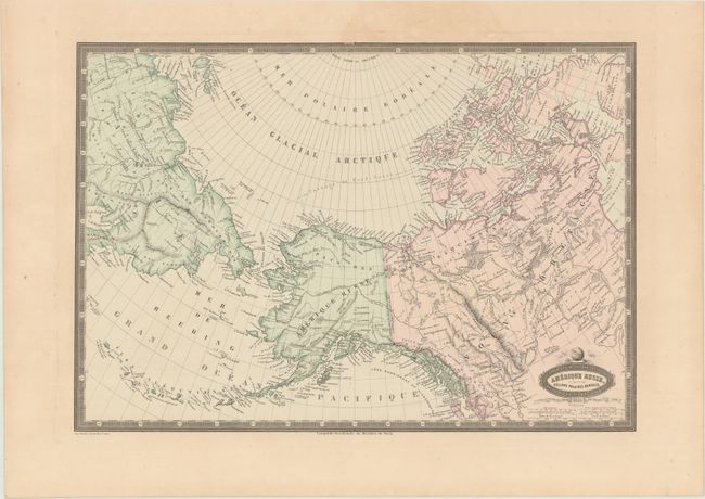
Auction 168, Lot 124
Subject: Northern United States & Canada, Alaska, Asia
Garnier, Francis Marie Joseph
Amerique Russe, et Partie des Regions Polaires Boreales, 1860
Size: 18.8 x 13 inches (47.8 x 33 cm)
Estimate: $140 - $170
Sold for: $90
Closed on 6/6/2018
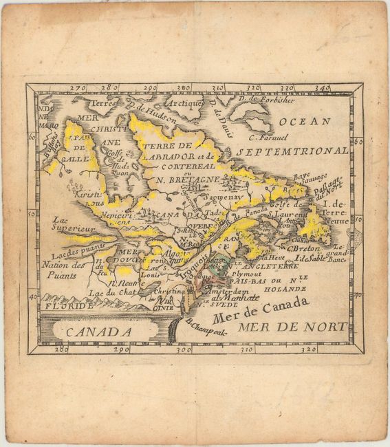
Auction 168, Lot 125
Subject: Colonial Northeastern United States & Canada
Duval, Pierre
Canada, 1682
Size: 4.8 x 3.8 inches (12.2 x 9.7 cm)
Estimate: $375 - $450
Sold for: $190
Closed on 6/6/2018
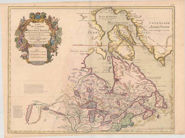
Auction 168, Lot 126
Subject: Colonial Northeastern United States & Canada, Great Lakes
Delisle, Guillaume
Carte du Canada ou de la Nouvelle France et des Decouvertes qui y ont ete faites…, 1718
Size: 25.5 x 19.7 inches (64.8 x 50 cm)
Estimate: $2,200 - $2,500
Delisle's Seminal Map of Canada and the Great Lakes
Sold for: $1,600
Closed on 6/6/2018
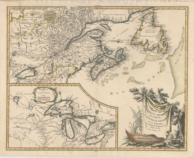
Auction 168, Lot 127
Subject: Colonial Northeastern United States & Canada, Great Lakes
Robert de Vaugondy, Didier
Partie de l'Amerique Septent? qui Comprend la Nouvelle France ou le Canada, 1755
Size: 23.5 x 18.6 inches (59.7 x 47.2 cm)
Estimate: $550 - $650
Sold for: $400
Closed on 6/6/2018
Auction 168, Lot 128
Subject: Central United States & Canada
U.S. Government
[17 Maps in Report] Boundary Between the United States and Great Britain. Message from the President of the United States..., 1838
Size: 5.5 x 8.8 inches (14 x 22.4 cm)
Estimate: $220 - $250
Sold for: $275
Closed on 6/6/2018
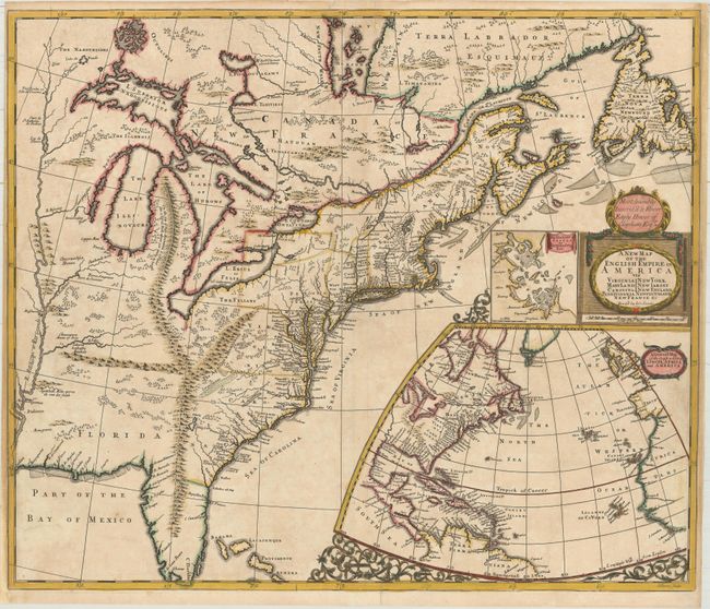
Auction 168, Lot 129
Subject: Colonial Eastern United States & Canada
Senex, John
A New Map of the English Empire in America viz Virginia New York Maryland New Iarsey Carolina New England Pennsylvania Newfoundland New France &c, 1719
Size: 23.6 x 19.9 inches (59.9 x 50.5 cm)
Estimate: $2,400 - $3,000
Important Map of the American Colonies
Sold for: $3,500
Closed on 6/6/2018
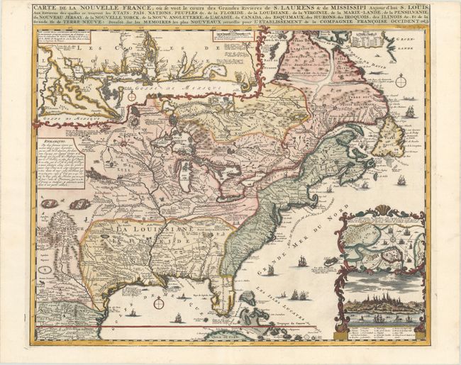
Auction 168, Lot 130
Subject: Colonial Eastern United States & Canada
Chatelain, Henry Abraham
Carte de la Nouvelle France, ou se Voit le Cours des Grandes Rivieres de S. Laurens & de Mississipi Aujour d'hui S. Louis, aux Environs des-quelles se Trouvent les Etats, Pais, Nations, Peuples &c..., 1720
Size: 19.4 x 16.6 inches (49.3 x 42.2 cm)
Estimate: $3,000 - $3,750
One of the Most Informative 18th Century Maps of the French Possessions in North America
Sold for: $2,200
Closed on 6/6/2018
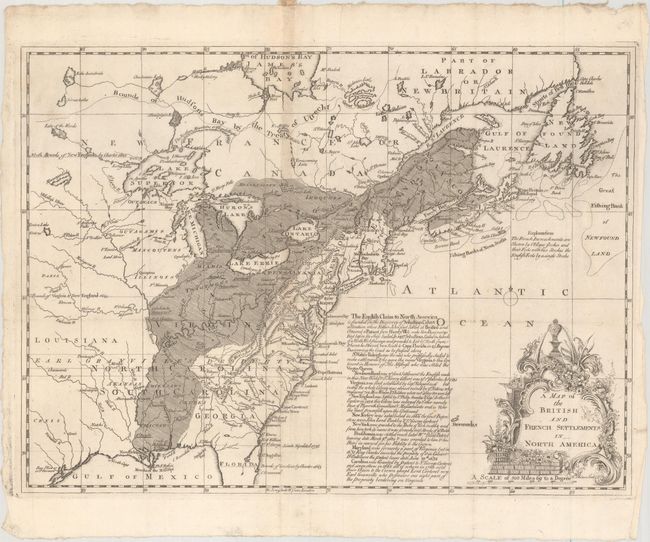
Auction 168, Lot 131
Subject: Colonial Eastern United States & Canada
Phinn, Thomas
A Map of the British and French Settlements in North America, 1755
Size: 15 x 10.9 inches (38.1 x 27.7 cm)
Estimate: $475 - $600
Sold for: $320
Closed on 6/6/2018
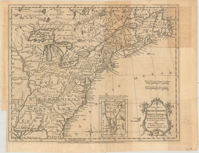
Auction 168, Lot 132
Subject: Colonial Eastern United States & Canada
Kitchin, Thomas
A New Map of the British Dominions in North America; with the Limits of the Governments Annexed Thereto by the Late Treaty of Peace, and Settled by Proclamation, October 7th, 1763, 1763
Size: 11.9 x 9.5 inches (30.2 x 24.1 cm)
Estimate: $325 - $400
Sold for: $240
Closed on 6/6/2018
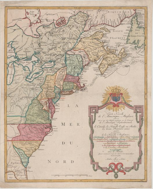
Auction 168, Lot 133
Subject: Colonial Eastern United States & Canada
Lotter, Mathias Albrecht
Carte Nouvelle de l'Amerique Angloise Contenant tout ce que les Anglois Possedent sur le Continent de l'Amerique Septentrionale Savoir le Canada, la Nouvelle Ecosse ou Acadie, les Treize Provinces Unies..., 1776
Size: 19.3 x 23.6 inches (49 x 59.9 cm)
Estimate: $1,100 - $1,400
Sold for: $1,100
Closed on 6/6/2018
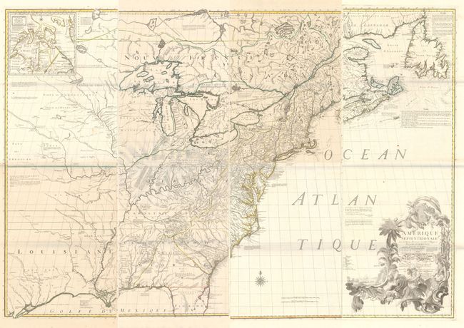
Auction 168, Lot 134
Subject: Colonial Eastern United States & Canada
Mitchell/Le Rouge
[On 8 Sheets] Amerique Septentrionale avec les Routes, Distances en Miles, Villages et Etablissements... / North America..., 1777
Size: 19 x 53 inches (48.3 x 134.6 cm)
Estimate: $10,000 - $13,000
Third French Edition of Mitchell's Monumental Map
Sold for: $7,500
Closed on 6/6/2018
Auction 168, Lot 135
Subject: Colonial Eastern United States & Canada
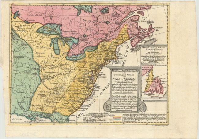
Sotzmann, Daniel Friedrich
Die Vereinigten Staaten von Nord-America. Nach der von Wm. Faden 1783 herausgegebenen Charte / Les Etats Unis de l'Amerique Septentrionale d'Apres la Carte de Wm. Faden Publiee a Londres en 1783..., 1785
Size: 10 x 7.6 inches (25.4 x 19.3 cm)
Estimate: $600 - $800
Rare, Multi-Lingual Reduced Version of Faden's Map of 1783
Unsold
Closed on 6/6/2018
Auction 168, Lot 136
Subject: Eastern United States & Canada
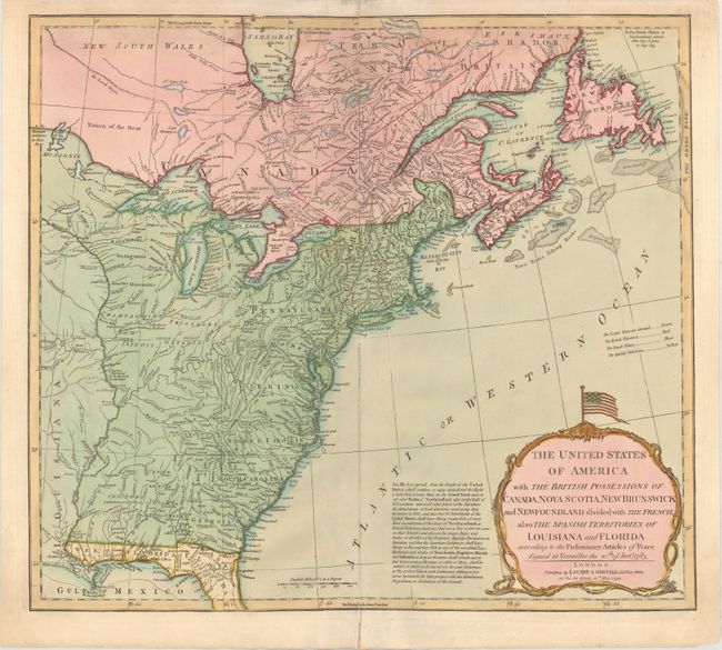
Laurie & Whittle
The United States of America with the British Possessions of Canada, Nova Scotia, New Brunswick and Newfoundland Divided with the French, Also the Spanish Territories of Louisiana and Florida..., 1794
Size: 19.9 x 17.8 inches (50.5 x 45.2 cm)
Estimate: $750 - $900
Sold for: $1,000
Closed on 6/6/2018
Auction 168, Lot 137
Subject: Eastern United States & Canada
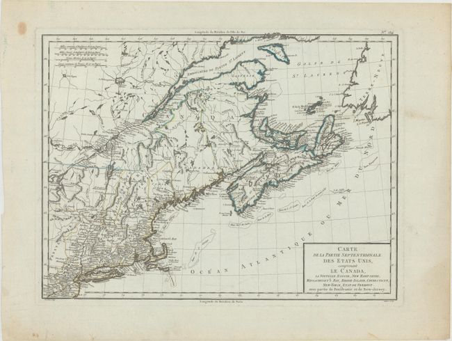
Tardieu, Pierre Francois
Carte de la Partie Septentrionale des Etats Unis, Comprenant le Canada, la Nouvelle Ecosse, New Hampshire, Massachuset's Bay, Rhode-Island, Connecticut, New-Yorck, Etat de Vermont..., 1797
Size: 16.8 x 12.6 inches (42.7 x 32 cm)
Estimate: $240 - $300
Sold for: $180
Closed on 6/6/2018
Auction 168, Lot 138
Subject: Eastern United States & Canada
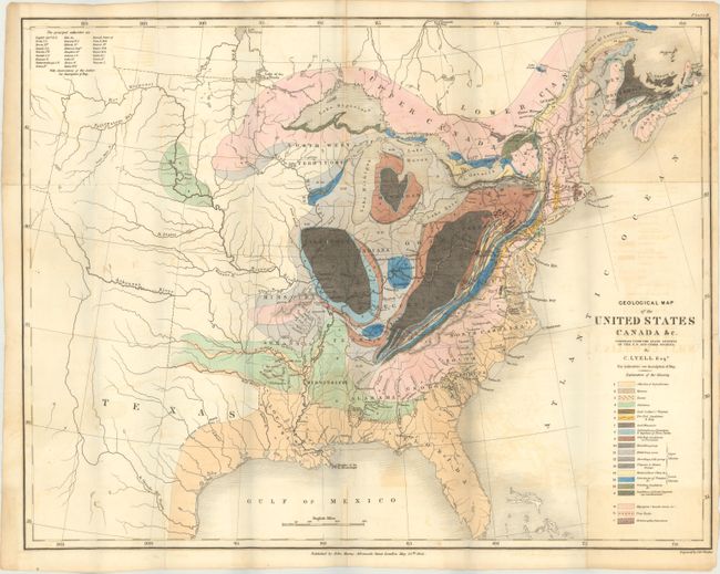
Lyell, Charles
Geological Map of the United States Canada &c. Compiled from the State Surveys of the U.S. and Other Sources [with] Travels in North America, in the Years 1841-2; with Geological Observations on the United States, Canada, and Nova Scotia, 1845
Size: 19.6 x 15.2 inches (49.8 x 38.6 cm)
Estimate: $750 - $900
First American Edition of Lyell's Important Account & Geological Map
Sold for: $750
Closed on 6/6/2018
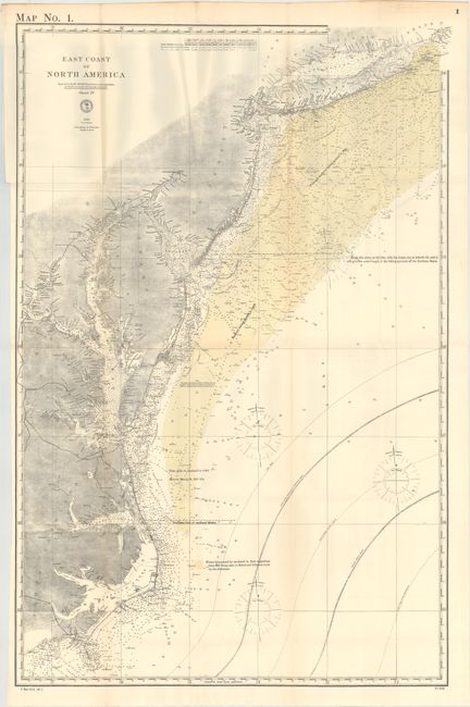
Auction 168, Lot 139
Subject: Eastern United States & Canada
U.S. Hydrographic Office
[Lot of 3] East Coast of North America [and] North East Coast of North America Sheet II [and] Sheet III [and] The River & Gulf of St. Lawrence, Newfoundland, Nova Scotia, and the Banks Adjacent, from the English Admiralty & French Marine Surveys, 1878
Size: See Description
Estimate: $250 - $325
Sold for: $100
Closed on 6/6/2018
Auction 168, Lot 140
Subject: Western United States & Canada
La Perouse, Comte Jean F. Galoup, de
Carte Generale d'une Partie de la Cote du Nord-Ouest de l'Amerique Reconnue par les Fregates Francaises la Boussole et l'Astrolabe, 1797
Size: 19.4 x 26.9 inches (49.3 x 68.3 cm)
Estimate: $275 - $350
Sold for: $190
Closed on 6/6/2018
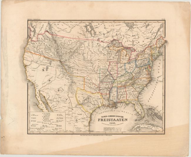
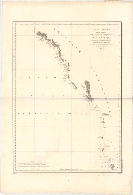
Auction 168, Lot 141
Subject: United States, Texas
Radefeld, Carl Christian Franz
Nord-Americanische Freistaaten, 1845
Size: 15.2 x 11.4 inches (38.6 x 29 cm)
Estimate: $200 - $230
Sold for: $150
Closed on 6/6/2018
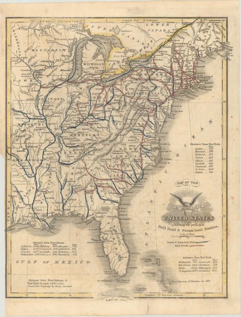
Auction 168, Lot 142
Subject: United States, Civil War
[Lot of 2] Map of the United States Exhibiting the Principal Rail Road & Steamboat Routes [and] United States, 1850-61
Size: See Description
Estimate: $250 - $325
Sold for: $180
Closed on 6/6/2018
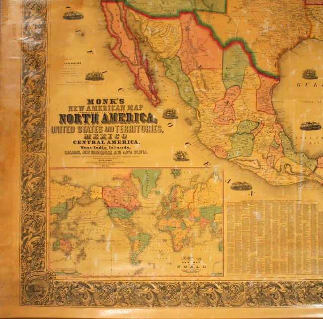
Auction 168, Lot 143
Subject: United States
Monk, Jacob
Monk's New American Map Exhibiting the Larger Portion of North America..., 1855
Size: 60 x 57 inches (152.4 x 144.8 cm)
Estimate: $800 - $950
Attractive Wall Map Featuring the Gold Region of California
Sold for: $600
Closed on 6/6/2018
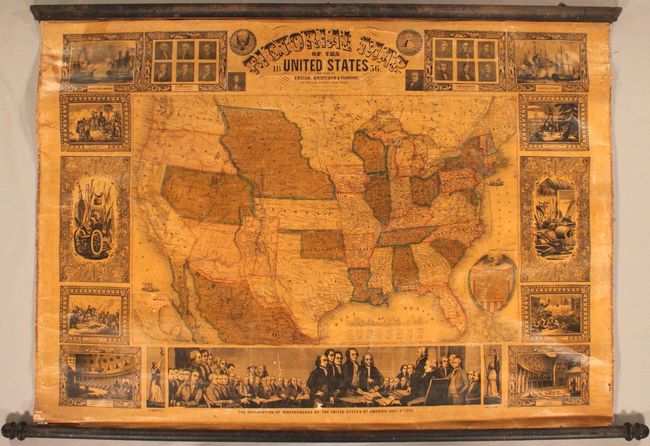
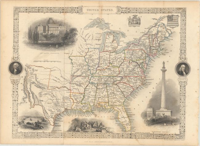
Auction 168, Lot 144
Subject: United States
Ensign, Bridgman & Fanning
Pictorial Map of the United States , 1856
Size: 39.9 x 28.9 inches (101.3 x 73.4 cm)
Estimate: $950 - $1,200
Sold for: $800
Closed on 6/6/2018
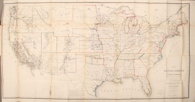
Auction 168, Lot 145
Subject: United States
General Land Office
Map of the United States and Territories Shewing the Extent of Public Surveys and Other Details... [bound in report], 1867
Size: 55.6 x 28 inches (141.2 x 71.1 cm)
Estimate: $250 - $325
Sold for: $150
Closed on 6/6/2018
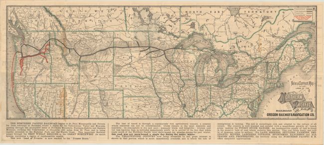
Auction 168, Lot 146
Subject: United States, Railroads
Rand McNally & Co.
[Lot of 2] New and Correct Map of the Lines of the Northern Pacific Railroad and Oregon Railway & Navigation Co. [and] Official Map of the Union Pacific Railway..., 1882-84
Size: See Description
Estimate: $250 - $325
Sold for: $275
Closed on 6/6/2018
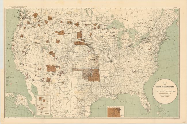
Auction 168, Lot 147
Subject: United States
U.S. Government
Map Showing Indian Reservations Within the Limits of the United States Compiled Under the Direction of the Hon. T.J. Morgan, 1894
Size: 33.4 x 21.1 inches (84.8 x 53.6 cm)
Estimate: $120 - $150
Sold for: $90
Closed on 6/6/2018
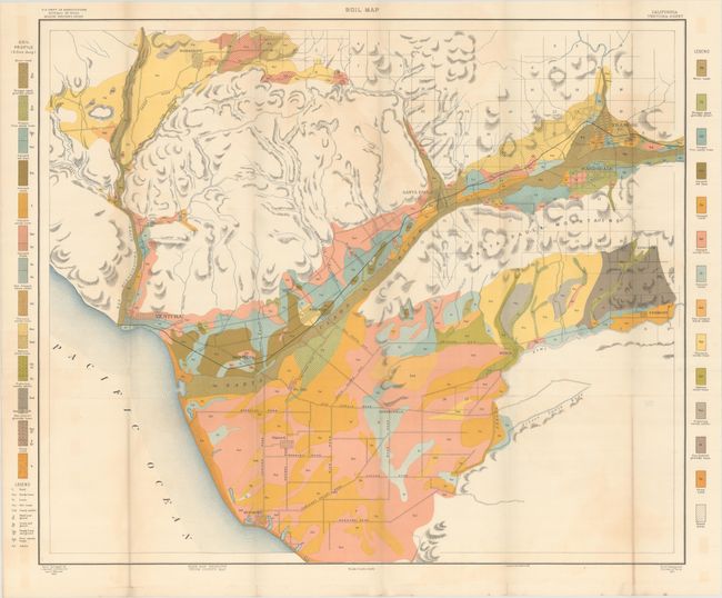
Auction 168, Lot 148
Subject: United States
U.S.D.A.
[Lot of 31 - U.S.D.A. Soil Maps], 1901
Size: 6 x 9.3 inches (15.2 x 23.6 cm)
Estimate: $240 - $300
Features A Number of Maps of Southern California
Unsold
Closed on 6/6/2018
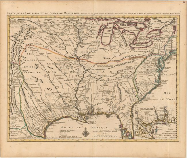
Auction 168, Lot 149
Subject: Colonial Eastern United States, Louisiana Territory
Delisle/Covens & Mortier
Carte de la Louisiane et du Cours du Mississipi Dressee sur un Grand Nombre de Memoires Entr'autres sur ceux de Mr. le Maire, 1733
Size: 23.5 x 17.2 inches (59.7 x 43.7 cm)
Estimate: $1,900 - $2,200
Delisle's Influential Map of the Louisiana Territory
Sold for: $1,400
Closed on 6/6/2018
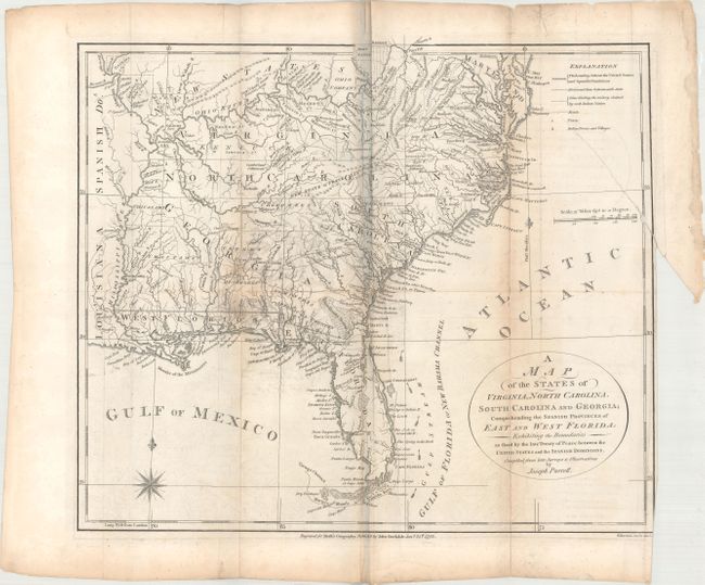
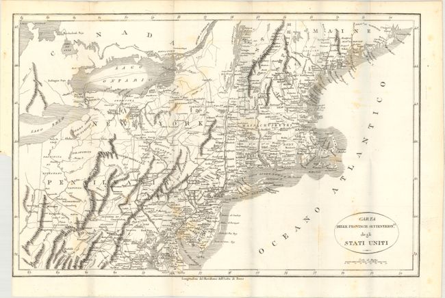
Auction 168, Lot 150
Subject: Eastern United States, Franklin
Morse, Jedidiah (Rev.)
[Lot of 3] A Map of the States of Virginia, North Carolina, South Carolina and Georgia; Comprehending the Spanish Provinces of East and West Florida... [and] A Map of the Northern and Middle States... [with] The American Geography..., 1792
Size: 14.6 x 12.6 inches (37.1 x 32 cm)
Estimate: $800 - $1,000
Includes Purcell's Map Locating the Proposed State of Franklin
Sold for: $650
Closed on 6/6/2018
Auction 168, Lot 151
Subject: Eastern United States
Tardieu, Antonie Francois
Carte Generale des Etats-Unis, 1806
Size: 18.8 x 15 inches (47.8 x 38.1 cm)
Estimate: $275 - $350
Sold for: $200
Closed on 6/6/2018
Auction 168, Lot 152
Subject: Eastern United States
Botta, Carlo
[Lot of 2] Carta delle Provincie Settentrionli. degli Stati Uniti [and] Carta delle Provincie Meridionali degli Stati-Uniti, 1819
Size: 19 x 12.4 inches (48.3 x 31.5 cm)
Estimate: $400 - $500
Sold for: $250
Closed on 6/6/2018
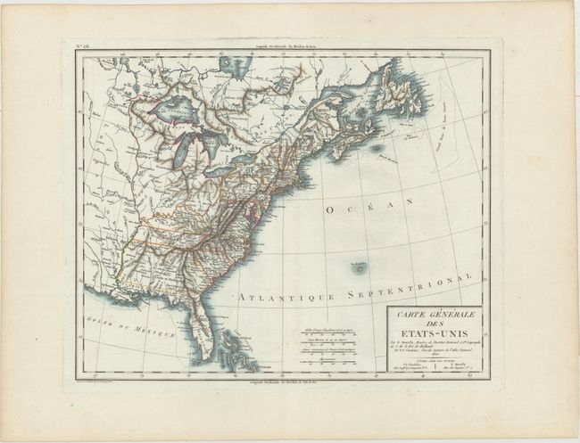
Auction 168, Lot 153
Subject: Eastern United States
United States, 1820
Size: 8.4 x 7.3 inches (21.3 x 18.5 cm)
Estimate: $350 - $425
Sold for: $250
Closed on 6/6/2018
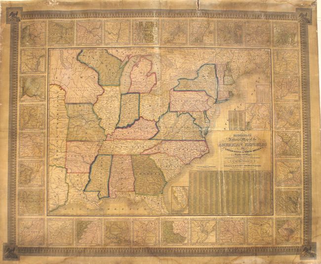
Auction 168, Lot 154
Subject: Eastern United States
Mitchell/Young
Mitchell's National Map of the American Republic or United States of North America. Together with Maps of the Vicinities of Thirty-Two of the Principal Cities and Towns in the Union, 1843
Size: 46.6 x 38.3 inches (118.4 x 97.3 cm)
Estimate: $800 - $1,000
Sold for: $400
Closed on 6/6/2018
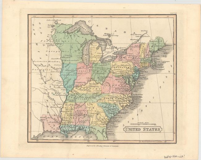
Auction 168, Lot 155
Subject: Eastern United States, Texas
Tallis, John
United States, 1850
Size: 13.4 x 9.7 inches (34 x 24.6 cm)
Estimate: $275 - $350
Sold for: $200
Closed on 6/6/2018
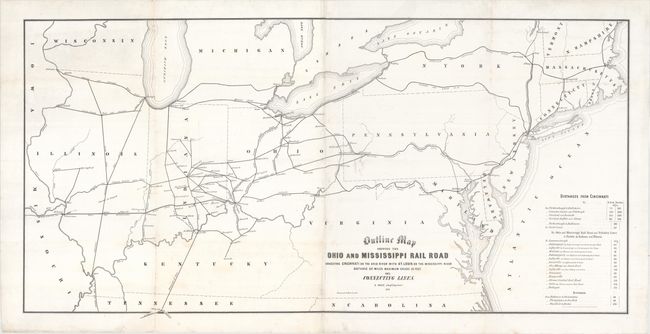
Auction 168, Lot 156
Subject: Eastern United States, Railroads
Railroad Companies, (Various)
Outline Map Shewing the Ohio and Mississippi Rail Road Connecting Cincinnati on the Ohio River with St. Louis on the Mississippi River..., 1851
Size: 38.9 x 19.3 inches (98.8 x 49 cm)
Estimate: $275 - $350
Sold for: $275
Closed on 6/6/2018
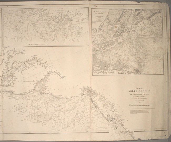
Auction 168, Lot 157
Subject: Eastern United States
Blunt, Edmund
Coast of North America, from Point Judith to Cape St. Antonio, (Island of Cuba) Including the Bahama Banks, 1853
Size: 132.7 x 30.7 inches (337.1 x 78 cm)
Estimate: $4,750 - $6,000
Impressive Blueback Chart of the Eastern Seaboard
Unsold
Closed on 6/6/2018
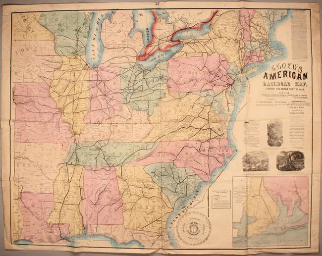
Auction 168, Lot 158
Subject: Eastern United States, Civil War
Lloyd, James T.
Lloyd's American Railroad Map, Showing the Whole Seat of War, 1861
Size: 47.6 x 37.3 inches (120.9 x 94.7 cm)
Estimate: $700 - $900
Rare Civil War Railroad Map
Sold for: $500
Closed on 6/6/2018
Auction 168, Lot 159
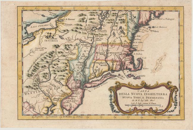
Subject: Colonial New England & Mid-Atlantic
Bellin, Jacques Nicolas
Carta della Nuova Inghilterra Nuova Yorc, e Pensilvania, 1781
Size: 11.6 x 7.9 inches (29.5 x 20.1 cm)
Estimate: $200 - $230
Sold for: $230
Closed on 6/6/2018
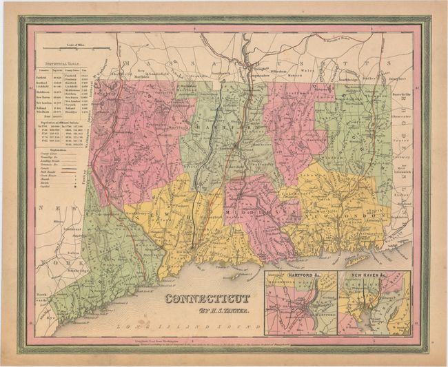
Auction 168, Lot 160
Subject: New England - United States
Tanner, Henry Schenck
[Lot of 4] Connecticut [and] Massachusetts and Rhode Island [and] New Hampshire & Vermont [and] A New Map of Maine, 1839-41
Size: See Description
Estimate: $300 - $375
Sold for: $100
Closed on 6/6/2018
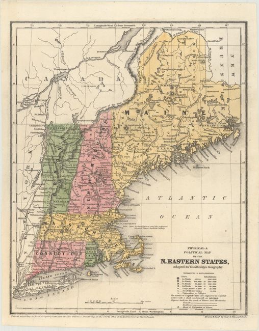
Auction 168, Lot 161
Subject: New England - United States
Woodbridge, William Channing
Physical & Political Map of the N. Eastern States, Adapted to Woodbridge's Geography, 1843
Size: 8.5 x 10.6 inches (21.6 x 26.9 cm)
Estimate: $70 - $90
NO RESERVE
Sold for: $16
Closed on 6/6/2018
Auction 168, Lot 162
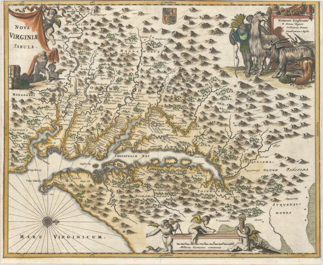
Subject: Colonial Mid-Atlantic United States
Hondius, Henricus
Nova Virginiae Tabula, 1645
Size: 19.6 x 15.1 inches (49.8 x 38.4 cm)
Estimate: $2,000 - $2,300
One of the Most Important 17th Century Maps of the Chesapeake Bay
Sold for: $1,200
Closed on 6/6/2018
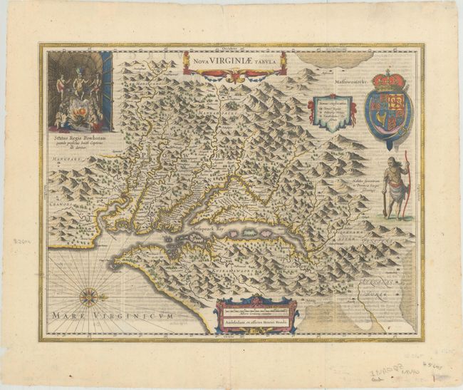
Auction 168, Lot 163
Subject: Colonial Mid-Atlantic United States
Montanus, Arnoldus
Nova Virginiae Tabula, 1671
Size: 14.1 x 11.5 inches (35.8 x 29.2 cm)
Estimate: $900 - $1,100
Sold for: $650
Closed on 6/6/2018
Auction 168, Lot 164
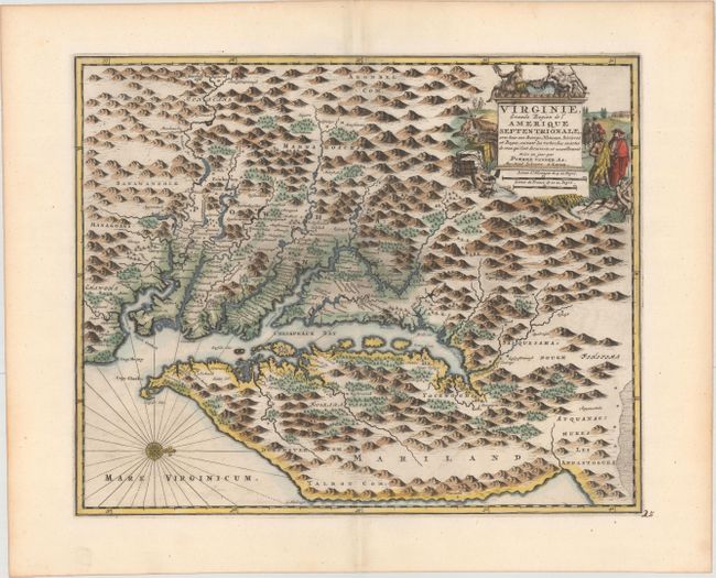
Subject: Colonial Mid-Atlantic United States
Aa, Pieter van der
Virginie, Grande Region de l'Amerique Septentrionale, avec tous Ses Bourgs, Hameaux, Rivieres et Bayes..., 1729
Size: 14.1 x 11.4 inches (35.8 x 29 cm)
Estimate: $1,600 - $1,900
Rare Derivative of John Smith's Map of the Chesapeake Bay
Sold for: $1,100
Closed on 6/6/2018
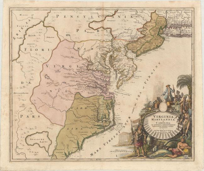
Auction 168, Lot 165
Subject: Colonial Mid-Atlantic United States
Homann, Johann Baptist
Virginia Marylandia et Carolina in America Septentrionali Britannorum Industria Excultae Repraesentatae, 1730
Size: 22.9 x 19.2 inches (58.2 x 48.8 cm)
Estimate: $1,600 - $2,000
Map Created to Promote German Immigration to the New World
Unsold
Closed on 6/6/2018
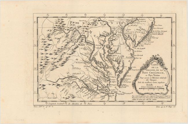
Auction 168, Lot 166
Subject: Colonial Mid-Atlantic United States
Bellin, Jacques Nicolas
Carte de la Virginie, de la Baye Chesapeack, et Pays Voisins pour Servir a l'Histoire Generale des Voyages..., 1757
Size: 11.3 x 7.3 inches (28.7 x 18.5 cm)
Estimate: $220 - $250
Sold for: $150
Closed on 6/6/2018
Auction 168, Lot 167
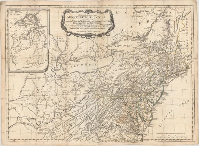
Subject: Colonial Mid-Atlantic United States
Sayer & Bennett
A General Map of the Middle British Colonies, in America. Containing Virginia, Maryland, the Delaware Counties, Pennsylvania and New Jersey. With the Addition of New York..., 1776
Size: 26.1 x 19.2 inches (66.3 x 48.8 cm)
Estimate: $4,000 - $4,750
Important British Map at the Outbreak of the American Revolution
Unsold
Closed on 6/6/2018
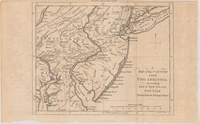
Auction 168, Lot 168
Subject: Colonial Mid-Atlantic United States, Revolutionary War
Lizars, Daniel
A Map of the Country Round Philadelphia Including Part of New Jersey New York Staten Island & Long Island, 1776
Size: 8.5 x 6.8 inches (21.6 x 17.3 cm)
Estimate: $200 - $230
Sold for: $170
Closed on 6/6/2018
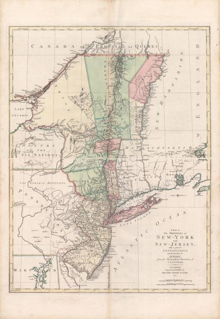
Auction 168, Lot 169
Subject: Colonial Mid-Atlantic United States
Lotter, Mathias Albrecht
[On 2 Sheets] A Map of the Provinces of New-York and New-Jersey, with a Part of Pennsylvania and the Province of Quebec. From the Topographical Observations of C.J. Sauthier, 1777
Size: 22.4 x 15 inches (56.9 x 38.1 cm)
Estimate: $2,200 - $2,500
Important Revolutionary War Map
Unsold
Closed on 6/6/2018
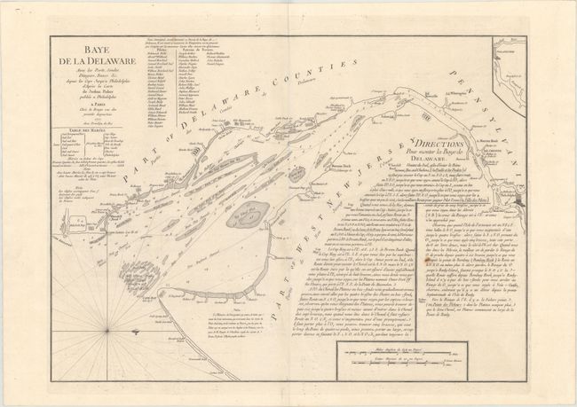
Auction 168, Lot 170
Subject: Colonial Mid-Atlantic United States, Delaware Bay
Le Rouge, George Louis
Baye de la Delaware avec les Ports, Sondes, Dangers, Bancs, &c. Depuis les Caps Jusqu'a Philadelphie..., 1777
Size: 25.1 x 18.4 inches (63.8 x 46.7 cm)
Estimate: $1,900 - $2,200
The Most Accurate Chart of Delaware Bay in the 18th Century
Unsold
Closed on 6/6/2018
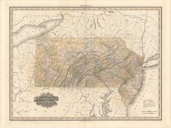
Auction 168, Lot 171
Subject: Pennsylvania, New Jersey
Tanner, Henry Schenck
Map of Pennsylvania and New Jersey, 1823
Size: 27.6 x 20.6 inches (70.1 x 52.3 cm)
Estimate: $475 - $600
Sold for: $275
Closed on 6/6/2018
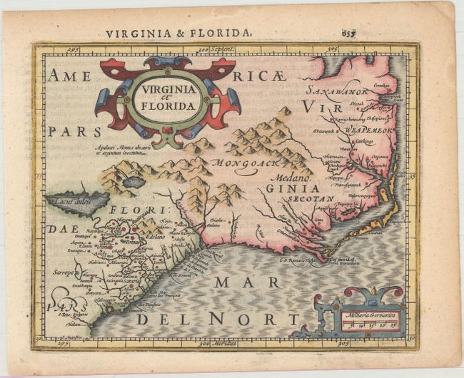
Auction 168, Lot 172
Subject: Colonial Southeastern United States
Mercator/Hondius
Virginia et Florida, 1610
Size: 7.3 x 5.8 inches (18.5 x 14.7 cm)
Estimate: $400 - $500
Sold for: $250
Closed on 6/6/2018
203 lots
Page 1 of 5